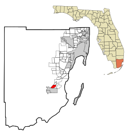
Leisure City, Florida

Last updated
Leisure City, Florida
Miami-Dade County Florida Incorporated and Unincorporated areas Leisure City Highlighted.svg
Location in Miami-Dade County and the state of Florida
Leisure City.gif
U.S. Census Bureau map showing CDP boundaries
Coordinates: 25°29′39″N80°26′10″W / 25.49417°N 80.43611°W / 25.49417; -80.43611 Coordinates: 25°29′39″N80°26′10″W / 25.49417°N 80.43611°W / 25.49417; -80.43611
CountryFlag of the United States.svg  United States
State Flag of Florida.svg  Florida
County   Miami-Dade
Area
[1]
  Total3.33 sq mi (8.62 km2)
  Land3.26 sq mi (8.45 km2)
  Water0.07 sq mi (0.17 km2)
Elevation
7 ft (2 m)
Population
 (2020) [2]
  Total26,324
  Density8,069.90/sq mi (3,115.59/km2)
Time zone UTC-5 (Eastern (EST))
  Summer (DST) UTC-4 (EDT)
ZIP code
33033 (Homestead)
Area code 305
FIPS code 12-39950 [3]
GNIS feature ID0285449 [4]

Leisure City is an unincorporated community and census-designated place (CDP) in Miami-Dade County, Florida, United States, that includes the smaller, older community of Modello in its northwestern section. The population was 26,324 at the 2020 census, [2] up from 22,655 in 2010. [5] It is most notable for the Coral Castle Museum, located in the Modello area.

Contents

Geography

Leisure City is located 27 miles (43 km) southwest of Miami at 25°29′39″N80°26′10″W / 25.49417°N 80.43611°W / 25.49417; -80.43611 (25.494037, -80.436229). [6] It is bordered to the south and east by the city of Homestead and to the north by unincorporated Naranja. Unincorporated Redland is to the northwest.

U.S. Route 1 runs along the northwest edge of the community, leading south into Homestead and northeast to Miami. The Homestead Extension of Florida's Turnpike runs along the Homestead city line at the southeast edge of the community, with access from Exit 2 (SW 157th Avenue) just south of Leisure City and from Exit 5 (SW 288th Street) at the community's eastern edge.

According to the United States Census Bureau, the CDP has a total area of 3.33 square miles (8.6 km2), of which 3.26 square miles (8.4 km2) are land and 0.07 square miles (0.18 km2), or 2.01%, are water. [1]

Demographics

Historical population
CensusPop.Note
1960 3,001
1980 17,905
1990 19,3798.2%
2000 22,15214.3%
2010 22,6552.3%
2020 26,32416.2%
source: [7]

2020 census

Leisure City racial composition
(Hispanics excluded from racial categories)
(NH = Non-Hispanic) [8]
RaceNumberPercentage
White (NH)1,5705.96%
Black or African American (NH)3,44113.07%
Native American or Alaska Native (NH)140.05%
Asian (NH)2130.81%
Some Other Race (NH)860.33%
Mixed/Multi-Racial (NH)2310.88%
Hispanic or Latino 20,76978.9%
Total26,324

As of the 2020 United States census, there were 26,324 people, 6,851 households, and 5,563 families residing in the CDP.

2000 census

At the 2000 census, [3] there were 22,152 people, 6,063 households and 5,044 families residing in the CDP. The population density was 6,490.0 inhabitants per square mile (2,505.8/km2). There were 6,615 housing units at an average density of 1,938.0 per square mile (748.3/km2). The racial makeup of the CDP was 65.03% White (15.2% were Non-Hispanic Whites,) [9] 18.00% African American, 0.20% Native American, 0.84% Asian, 0.03% Pacific Islander, 11.42% from other races, and 4.48% from two or more races. Hispanic or Latino of any race were 65.30% of the population.

There were 6,063 households, of which 50.1% had children under the age of 18 living with them, 54.7% were married couples living together, 21.0% had a female householder with no husband present, and 16.8% were non-families. 12.7% of all households were made up of individuals, and 4.3% had someone living alone who was 65 years of age or older. The average household size was 3.65 and the average family size was 3.94.

36.2% of the population were under the age of 18, 10.9% from 18 to 24, 30.1% from 25 to 44, 16.5% from 45 to 64, and 6.3% who were 65 years of age or older. The median age was 27 years. For every 100 females, there were 101.5 males. For every 100 females age 18 and over, there were 98.1 males.

The median household income was $29,091 and the median family income was $29,277. Males had a median income of $22,320 and females $18,619. The per capita income was $9,966. About 22.4% of families and 25.0% of the population were below the poverty line, including 33.3% of those under age 18 and 18.3% of those age 65 or over.

In 2000, speakers of Spanish as a first language accounted for 64.83% of residents, while English made up 31.02%, French Creole was at 4.01%, and Tagalog was the mother tongue of 0.12% of the population. [10]

Education

Leisure City is a part of the Miami-Dade County Public Schools system and has three schools: Leisure City K-8, Homestead High School and South Dade High School.

Climate

The Köppen Climate Classification sub-type for this climate is "Aw" (Tropical Savanna Climate). [11]

Climate data for Leisure City, Florida
MonthJanFebMarAprMayJunJulAugSepOctNovDecYear
Average high °C (°F)25
(77)
26
(78)
27
(81)
29
(84)
31
(87)
32
(89)
32
(90)
33
(91)
32
(89)
30
(86)
27
(81)
26
(78)
29
(84)
Average low °C (°F)12
(54)
12
(54)
14
(58)
16
(61)
19
(66)
21
(70)
22
(71)
22
(71)
22
(71)
19
(67)
16
(61)
13
(56)
17
(63)
Average precipitation mm (inches)43
(1.7)
48
(1.9)
56
(2.2)
84
(3.3)
160
(6.4)
230
(9.2)
200
(7.8)
210
(8.2)
250
(9.7)
200
(7.7)
66
(2.6)
33
(1.3)
1,600
(62)
Source: Weatherbase [12]

Related Research Articles

<span class="mw-page-title-main">Country Club, Florida</span> Census-designated place in Florida, United States

Country Club is a census-designated place and a suburban unincorporated community located in northwest Miami-Dade County, Florida, United States. It is named after the Country Club of Miami, which was established in 1961 in what was then an unpopulated and undeveloped section of the county. The population was 49,967 at the 2020 census, up from 3,408 in 1990.

<span class="mw-page-title-main">Gladeview, Florida</span> Census-designated place in Florida, United States

Gladeview is a census-designated place (CDP) in Miami-Dade County, Florida, United States. The population was 14,927 at the 2020 census, up from 11,535 in 2010.

<span class="mw-page-title-main">Glenvar Heights, Florida</span> Census-designated place in Florida, United States

Glenvar Heights is a census-designated place (CDP) and neighborhood in Miami-Dade County, Florida, United States. The population was 20,786 at the 2020 census, up from 16,898 in 2010. The community is served by the Miami ZIP codes 33143 and 33155.

<span class="mw-page-title-main">Golden Glades, Florida</span> Census-designated place in Florida, United States

Golden Glades is a census-designated place (CDP) in Miami-Dade County, Florida, United States. The population was 32,499 at the 2020 census.

<span class="mw-page-title-main">Goulds, Florida</span> Census-designated place in Florida, United States

Goulds is an unincorporated community and census-designated place (CDP) in Miami-Dade County, Florida, United States. The area was originally populated as the result of a stop on the Florida East Coast Railroad. The railroad depot was located near the current Southwest 224th Street. The community was named after its operator, Lyman Gould, who cut trees for railroad ties. As of the 2020 census, the population stood at 11,446, up from 10,103 in 2010.

<span class="mw-page-title-main">Homestead Base, Florida</span> Census-designated place in Florida, United States

Homestead Base is a census-designated place (CDP) in Miami-Dade County, Florida, United States. The population was 999 at the 2020 census. The CDP comprises the extent of Homestead Air Reserve Base plus some surrounding land.

<span class="mw-page-title-main">Kendall, Florida</span> Census-designated place in Florida, United States

Kendall is an unincorporated area and census-designated place in Miami-Dade County, Florida. At the 2020 census, the area had a population of 80,241.

<span class="mw-page-title-main">Kendall West, Florida</span> Census-designated place in Florida, United States

Kendall West is a census-designated place and unincorporated community in Miami-Dade County, Florida, west of the Florida Turnpike. The population was 36,536 at the 2020 census.

<span class="mw-page-title-main">Lakes by the Bay, Florida</span> Neighborhood in Miami-Dade, Florida, United States

Lakes by the Bay is a neighborhood and former census-designated place (CDP) in Miami-Dade County, Florida, United States. The population was 9,055 at the 2000 census. In 2005, the area of the CDP was included in the town of Cutler Bay.

<span class="mw-page-title-main">Naranja, Florida</span> Census-designated place in Florida, United States

Naranja is an unincorporated community and census-designated place (CDP) in Miami-Dade County, Florida, United States. Many orange groves were once located in this area, so the community name came from the Spanish word for orange, naranja, though the pronunciation among the local residents is "Na-Ran-Jah". Naranja was also a stop for the Florida East Coast Railroad that once ran through this area. The population was 13,509 at the 2020 census, up from 8,303 in 2010.

<span class="mw-page-title-main">Olympia Heights, Florida</span> Census-designated place in Florida, United States

Olympia Heights is a census-designated place in Miami-Dade County, Florida, United States. The population was 12,873 at the 2020 census.

<span class="mw-page-title-main">Palm Springs North, Florida</span> Census-designated place in Florida, United States

Palm Springs North is an unincorporated community and census-designated place (CDP) in Miami-Dade County, Florida, United States. The population was 5,030 at the 2020 census.

<span class="mw-page-title-main">Palmetto Estates, Florida</span> Census-designated place in Florida, United States

Palmetto Estates is an unincorporated area and census-designated place (CDP) in Miami-Dade County, Florida, United States. The population was 13,498 at the 2020 census.

<span class="mw-page-title-main">Pinewood, Florida</span> Census-designated place in Florida, United States

Pinewood is an unincorporated community and census-designated place (CDP) in Miami-Dade County, Florida, United States. The population was 17,246 at the 2020 census.

<span class="mw-page-title-main">Princeton, Florida</span> Census-designated place in Florida, United States

Princeton is a census-designated place (CDP) and unincorporated community in Miami-Dade County, Florida, United States. The population was 39,208 at the 2020 census, up from 22,038 at the 2010 census.

<span class="mw-page-title-main">Richmond Heights, Florida</span> Census-designated place in Florida, United States

Richmond Heights is a census-designated place (CDP) in Miami-Dade County, Florida, United States. The population was 8,944 at the 2020 census.

<span class="mw-page-title-main">The Hammocks, Florida</span> Census-designated place in Florida, United States

The Hammocks is a planned community and census-designated place in Miami-Dade County, Florida, United States. The population was 59,480 at the 2020 census, up from 51,003 in 2010.

<span class="mw-page-title-main">West Perrine, Florida</span> Census-designated place in Florida, United States

West Perrine is a census-designated place (CDP) in Miami-Dade County, Florida, United States. Prior to the 2000 census it was part of Perrine. The other part of Perrine became the East Perrine CDP for the 2000 census and is now part of the incorporated Village of Palmetto Bay. West Perrine is still an unincorporated area, although some residents have discussed the possibility of incorporating Perrine. The population was 10,602 at the 2020 census, up from 9,460 in 2010. The name derives from a land grant issued to the heirs of Henry Perrine, an agriculturist.

<span class="mw-page-title-main">Westwood Lakes, Florida</span> Census-designated place in Florida, United States

Westwood Lakes is a census-designated place and unincorporated part of Miami-Dade County, Florida, United States. The population was 11,373 at the 2020 census.

<span class="mw-page-title-main">South Miami Heights, Florida</span> Census-designated place in Florida, United States

South Miami Heights is a census-designated place (CDP), originally known as Eureka, in Miami-Dade County, within the U.S. state of Florida. The population was 36,770 as of the 2020 census.

References

  1. 1 2 "2022 U.S. Gazetteer Files: Florida". United States Census Bureau. Retrieved January 10, 2023.
  2. 1 2 "P1. Race – Leisure City CDP, Florida: 2020 DEC Redistricting Data (PL 94-171)". U.S. Census Bureau. Retrieved January 10, 2023.
  3. 1 2 "U.S. Census website". United States Census Bureau . Retrieved 2008-01-31.
  4. "US Board on Geographic Names". United States Geological Survey. October 25, 2007. Retrieved January 31, 2008.
  5. "P1. Race – Leisure City CDP, Florida: 2010 DEC Redistricting Data (PL 94-171)". U.S. Census Bureau. Retrieved January 10, 2023.
  6. "US Gazetteer files: 2010, 2000, and 1990". United States Census Bureau. February 12, 2011. Retrieved April 23, 2011.
  7. "CENSUS OF POPULATION AND HOUSING (1790-2000)". U.S. Census Bureau . Retrieved July 17, 2010.
    - Census of Population, 1960: Number of Inhabitants, General Population Counts. United States Census Bureau. Retrieved September 8, 2013.
    - Not returned separately by enumerators in 1970
  8. "Explore Census Data". data.census.gov. Retrieved 2022-02-09.
  9. "Demographics of Leisure City, FL". MuniNetGuide.com. Retrieved November 6, 2007.
  10. "MLA Data Center Results of Leisure City, FL". Modern Language Association . Retrieved November 6, 2007.
  11. Summary for Leisure City, Florida
  12. "Weatherbase.com". Weatherbase. 2013. Retrieved on August 2, 2013.