Tenmile Corner, Florida

Last updated

Tenmile Corner
Unincorporated Community
USA Florida location map.svg
Red pog.svg
Tenmile Corner
Coordinates: 25°36′57″N80°51′26″W / 25.61583°N 80.85722°W / 25.61583; -80.85722
CountryUnited States
StateFlag of Florida.svg  Florida
County Miami-Dade
Elevation
3 ft (0.9 m)

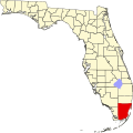
Tenmile Corner is an unincorporated community in western Miami-Dade County, Florida, located on the border between Big Cypress National Preserve and Everglades National Park. [1] [2] It is the site of an NPS weather station. [3]

Geography

Tenmile Corner is located at 25.6159407, −80.8572889 with an elevation of 1 meter (3 feet). [4]

Related Research Articles

<span class="mw-page-title-main">Collier County, Florida</span> County in Florida, United States

Collier County is a county in the U.S. state of Florida. As of the 2020 census, its population was 375,752; an increase of 16.9% since the 2010 United States Census. Its county seat is East Naples, where the county offices were moved from Everglades City in 1962.

<span class="mw-page-title-main">Monroe County, Florida</span> County in Florida, United States

Monroe County is the southernmost county of the state of Florida. As of the 2020 census, the population was 82,874. Its county seat is Key West. Monroe County includes the islands of the Florida Keys and comprises the Key West-Key Largo Micropolitan Statistical Area. Over 99.9% of the county's population lives on the Florida Keys. The mainland, which is part of the Everglades, comprises 87% of the county's land area and is virtually uninhabited with only 17 people recorded in the 2020 census.

<span class="mw-page-title-main">Doral, Florida</span> City in Florida

Doral is a city in Miami-Dade County, Florida, United States. One of 34 municipalities in the county, it is located 5 miles (8 km) west of Miami International Airport and 13 miles (21 km) west of Downtown Miami. Doral occupies 15 square miles (39 km2) bordered on the west by the Ronald Reagan Turnpike and the Florida Everglades, on the north by the town of Medley, on the east by the Palmetto Expressway and on the south by the Dolphin Expressway and the city of Sweetwater. The city is part of the Miami metropolitan area of South Florida. As of the 2020 census, Doral had a population of 75,874, up from 45,704 in 2010.

<span class="mw-page-title-main">Islandia, Florida</span> Unincorporated community in Florida, United States

Islandia is an unincorporated community and former city in Miami-Dade County, Florida, United States. It is located in the upper Florida Keys on the islands of Elliott Key and other nearby keys, such as Totten Key. It was the only municipality in the Florida Keys not located in neighboring Monroe County. The population was 18 at the 2010 Census. Most residents of the city were National Park Service employees.

<span class="mw-page-title-main">Sweetwater, Miami-Dade County, Florida</span> City in Florida

Sweetwater is a city in Miami-Dade County, Florida, United States. The city is part of the Miami metropolitan area of South Florida. As of the 2020 census, the population was 19,363, up from 13,499 in 2010.

<span class="mw-page-title-main">Westwood Lakes, Florida</span> Census-designated place in Florida

Westwood Lakes is a census-designated place and unincorporated community of Miami-Dade County, Florida, United States. It is part of the Miami metropolitan area of South Florida. The population was 11,373 at the 2020 census.

The Tamiami Trail is the southernmost 284 miles (457 km) of U.S. Highway 41 (US 41) from State Road 60 (SR 60) in Tampa to US 1 in Miami. A portion of the road also has the hidden designation of State Road 90 (SR 90).

<span class="mw-page-title-main">Big Cypress National Preserve</span> Over 729,000 acres in Florida (US) managed by the National Park Service

Big Cypress National Preserve is a United States National Preserve located in South Florida, about 45 miles west of Miami on the Atlantic coastal plain. The 720,000-acre (2,900 km2) Big Cypress, along with Big Thicket National Preserve in Texas, became the first national preserves in the United States National Park System when they were established on October 11, 1974. In 2008, Florida film producer Elam Stoltzfus featured the preserve in a PBS documentary.

<span class="mw-page-title-main">Palmetto Bay, Florida</span> Village in Florida

Palmetto Bay is a suburban incorporated village in Miami-Dade County, Florida, United States. Palmetto Bay includes two neighborhoods that were former census-designated places, Cutler and East Perrine. The village is part of the Miami metropolitan area of South Florida. The population was 24,439 as of the 2020 US census.

<span class="mw-page-title-main">Withlacoochee River (Florida)</span> River in Florida, United States

The Withlacoochee River or Crooked River is a river in central Florida, in the United States. It originates in the Green Swamp, east of Polk City, flowing west, then north, then northwest and finally west again before emptying into the Gulf of Mexico near Yankeetown. The river is 141 miles (227 km) long and has a drainage basin of 1,170 square miles (3,000 km2).

<span class="mw-page-title-main">Florida's 18th congressional district</span> U.S. House district for Florida

Florida's 18th congressional district is an electoral district for the U.S. Congress, located in the Florida Heartland. In the 2020 redistricting cycle, the district was redrawn to cover inland counties of DeSoto, Glades, Hardee, Hendry, Highlands, and Okeechobee, as well as most of Polk County and some of Immokalee in Collier County. It is essentially the successor to the old 15th district. The district is currently represented by Republican Scott Franklin.

<span class="mw-page-title-main">Miami-Dade Fire Rescue Department</span> Municipal fire brigade in the Miami-Dade County

The Miami-Dade Fire Rescue Department (MDFR) provides fire protection and emergency medical services to the unincorporated parts of Miami-Dade County, Florida, along with 30 municipalities located within the county. In all the department is responsible for 1,883 square miles (4,880 km2) of land.

Doctors Charter School of Miami Shores is a public charter school located on 5 acres (20,000 m2) at Barry University Campus in Miami Shores, in the U.S. state of Florida.

<span class="mw-page-title-main">Miccosukee Indian Reservation</span> Native American homeland in Florida, US

The Miccosukee Indian Reservation is the homeland of the Miccosukee tribe of Native Americans. It is divided into three sections in two counties of southern Florida, United States. Their total land area is 128.256 sq mi (332.18 km2). The Miccosukee Reservation have members living on and off the reservation.

<span class="mw-page-title-main">Dade-Collier Training and Transition Airport</span> Public airport in the Florida Everglades

Dade-Collier Training and Transition Airport is a public airport located within the Florida Everglades, 36 miles (58 km) west of the central business district of Miami, in Collier County, Florida, United States. It is owned by Miami-Dade County and operated by the Miami-Dade Aviation Department. The airport is on Tamiami Trail near the border between Dade and Collier counties in central South Florida.

Coopertown is a small unincorporated community in Miami-Dade County, Florida, United States. It is located about 20 miles (32 km) west of Miami on U.S. Route 41. Coopertown is most notable for housing Coopertown Airboat Rides, a tourist attraction founded in 1945.

<span class="mw-page-title-main">The Roads</span> Neighborhood of Miami in Miami-Dade County, Florida, United States

The Roads is a neighborhood of Miami in Miami-Dade County, Florida. It is a triangular area located south of SW 11th Street, between SW 12th Avenue and SW 15th Road, just west of Brickell.

<span class="mw-page-title-main">Miami-Dade County, Florida</span> County in Florida, United States

Miami-Dade County is a county located in the southeastern part of the U.S. state of Florida. The county had a population of 2,701,767 as of the 2020 census, making it the most populous county in Florida and the seventh-most-populous county in the United States. It is Florida's third largest county in terms of land area with 1,946 square miles (5,040 km2). The county seat is Miami, the core of the nation's ninth-largest and world's 65th-largest metropolitan area with a 2020 population of 6.138 million people, exceeding the population of 31 of the nation's 50 states as of 2022.

<span class="mw-page-title-main">Florida's 26th congressional district</span> U.S. House district for Florida

Florida's 26th congressional district is an electoral district for the U.S. Congress, which was first created in South Florida in 2013 as a result of Florida's population gain in the 2010 census. In the 2020 redistricting cycle, it was drawn as a successor to the previous 25th district and includes most of inland Collier County as well as the northwestern suburbs of Miami, including Doral, Hialeah, Miami Lakes, and some neighborhoods in Miami itself, such as Allapattah and Wynwood. The previous iteration of the 26th district, which included Monroe County and the southwestern suburbs of Miami, was instead renamed as the newly created 28th district.

<span class="mw-page-title-main">First Presbyterian Church (Miami, Florida)</span>

First Presbyterian Church is a historic church in Miami, Florida, USA. It is located at 609 Brickell Avenue in Greater Downtown Miami. Built in 1949, it was placed on the National Register of Historic Places in 1989, and designated historic by the City of Miami in 2003. The congregation dates back as far as the city of Miami, 1896, with the original building on another property being funded by Henry Flagler in 1900. The architect of the current building was Lester Geisler. The building represents a late example of the Mediterranean Revival architecture, popular in South Florida earlier in the century. The building sits on a three-acre property surrounded by high-rises. Built for a congregation of over 1,000, church membership dwindled from 1400 to less than 150 by the early aughts.

References

  1. "Tenmile Corner (Miami-Dade County, FL)". roadsidethoughts.com. Retrieved November 5, 2023.
  2. Big Cypress National Preserve Addition, General Management Plan/wilderness Study/off-road Vehicle Management Plan: Environmental Impact Statement. 2010.
  3. "Ten Mile Corner Florida". wrcc.dri.edu. Retrieved November 5, 2023.
  4. "Geographic Names Information System". edits.nationalmap.gov. Retrieved November 5, 2023.

25°36′57″N80°51′26″W / 25.6159407°N 80.8572889°W / 25.6159407; -80.8572889