Hengchun 恆春 Kōshun | |
|---|---|
| Hengchun Township · 恆春鎮 | |
 Beach in Kenting | |
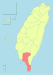
 Hengchun Township in Pingtung County | |
| Country | Taiwan |
| Region | Southern Taiwan |
| Government | |
| • Mayor | Lu Yu-tung (盧玉棟) |
| Area | |
• Total | 136.7630 km2 (52.8045 sq mi) |
| Population (February 2024) | |
• Total | 29,702 |
| • Density | 220/km2 (560/sq mi) |
| Households | 10568 |
| Divisions | 17 villages, 272 neighborhoods |
| Postal code | 946 |
| Website | www.hengchuen.gov.tw (in Chinese) |
| Hengchun | |||||||||||||||||||
|---|---|---|---|---|---|---|---|---|---|---|---|---|---|---|---|---|---|---|---|
| Chinese name | |||||||||||||||||||
| Traditional Chinese | 恆春 | ||||||||||||||||||
| Literal meaning | Eternal Spring | ||||||||||||||||||
| |||||||||||||||||||
This section needs additional citations for verification .(July 2021) |
Hengchun is the southernmost administrative division of the island. It is bordered to the northwest by Checheng Township and to the northeast by Manzhou Township.
Climate
| Hengchun (2009–2013) | ||||||||||||||||||||||||||||||||||||||||||||||||||||||||||||
|---|---|---|---|---|---|---|---|---|---|---|---|---|---|---|---|---|---|---|---|---|---|---|---|---|---|---|---|---|---|---|---|---|---|---|---|---|---|---|---|---|---|---|---|---|---|---|---|---|---|---|---|---|---|---|---|---|---|---|---|---|
| Climate chart (explanation) | ||||||||||||||||||||||||||||||||||||||||||||||||||||||||||||
| ||||||||||||||||||||||||||||||||||||||||||||||||||||||||||||
| ||||||||||||||||||||||||||||||||||||||||||||||||||||||||||||
Hengchun is well known for its tropical monsoon climate with warm temperatures year round, as befits its name. It usually has neither a cool winter nor an extremely hot summer, with average monthly mean temperatures ranging between 21 and 28 degrees Celsius. The climate is generally divided into two seasons, the cooler and drier season and the warmer and wetter season. During the cool and dry season from early December to late March of the following year, precipitation are relatively low with temperatures ranging from 18 to 26 degrees Celsius, occasional cold fronts can drop both the day and the night time temperatures by around 2–4 °C, while temperatures during a clear sunny day can reach as high as 28–30 °C. During the warm and wet season temperature range from 24 to 32 degrees Celsius with a relatively abundant rainfall especially from May–October, when Taiwan is affected by the Pacific typhoon season.
Hengchun's spring-like climate is very much dictated by its location surrounded by the ocean, resulting in a noticeably smaller difference between the day and night temperatures than most other townships of Pingtung. Hengchun is usually cooler than other townships in the county during daytime and warmer than others during the night, especially during the winter months, when daily lows usually hovers around 18–20 degrees Celsius at Hengchun and around 15–18 at Pingtung city, while daily highs usually hovers around 24–26 degrees Celsius at the township and 25–28 at Pingtung City. Temperatures dips below 15 degrees Celsius on average once every 3 years, mostly on early mornings of January when Taiwan is affected by a cold front.
The climate is also supportive of tropical rainforests (tropical monsoon rainforest) which occupied the entire Hengchun peninsula, while palm trees and other tropical vegetation grows on the coastlines, much like the rest of Pingtung.
The Hengchun Peninsula experiences strong katabatic winds. [14]
| Climate data for Hengchun (1991–2020 normals, extremes 1897–present) | |||||||||||||
|---|---|---|---|---|---|---|---|---|---|---|---|---|---|
| Month | Jan | Feb | Mar | Apr | May | Jun | Jul | Aug | Sep | Oct | Nov | Dec | Year |
| Record high °C (°F) | 32.2 (90.0) | 32.4 (90.3) | 34.2 (93.6) | 35.8 (96.4) | 37.1 (98.8) | 36.4 (97.5) | 35.6 (96.1) | 35.3 (95.5) | 36.0 (96.8) | 34.1 (93.4) | 33.8 (92.8) | 32.5 (90.5) | 37.1 (98.8) |
| Mean daily maximum °C (°F) | 24.4 (75.9) | 25.5 (77.9) | 27.3 (81.1) | 29.5 (85.1) | 31.2 (88.2) | 31.8 (89.2) | 32.1 (89.8) | 31.8 (89.2) | 31.3 (88.3) | 29.7 (85.5) | 27.8 (82.0) | 25.1 (77.2) | 29.0 (84.1) |
| Daily mean °C (°F) | 21.1 (70.0) | 21.7 (71.1) | 23.3 (73.9) | 25.4 (77.7) | 27.3 (81.1) | 28.4 (83.1) | 28.7 (83.7) | 28.3 (82.9) | 27.8 (82.0) | 26.5 (79.7) | 24.7 (76.5) | 22.2 (72.0) | 25.5 (77.8) |
| Mean daily minimum °C (°F) | 18.6 (65.5) | 19.0 (66.2) | 20.5 (68.9) | 22.6 (72.7) | 24.5 (76.1) | 25.8 (78.4) | 26.0 (78.8) | 25.6 (78.1) | 25.1 (77.2) | 24.1 (75.4) | 22.5 (72.5) | 20.0 (68.0) | 22.9 (73.1) |
| Record low °C (°F) | 8.4 (47.1) | 9.8 (49.6) | 10.4 (50.7) | 14.7 (58.5) | 17.1 (62.8) | 18.6 (65.5) | 19.4 (66.9) | 19.5 (67.1) | 18.7 (65.7) | 16.0 (60.8) | 12.7 (54.9) | 9.5 (49.1) | 8.4 (47.1) |
| Average precipitation mm (inches) | 21.8 (0.86) | 23.2 (0.91) | 16.0 (0.63) | 35.2 (1.39) | 146.6 (5.77) | 350.7 (13.81) | 391.3 (15.41) | 533.4 (21.00) | 320.3 (12.61) | 125.3 (4.93) | 58.3 (2.30) | 29 (1.1) | 2,051.1 (80.72) |
| Average precipitation days (≥ 0.1 mm) | 5.1 | 5.0 | 3.2 | 4.3 | 9.4 | 15.0 | 15.8 | 17.5 | 13.5 | 8.6 | 4.7 | 4.0 | 106.1 |
| Average relative humidity (%) | 70.8 | 72.0 | 71.8 | 73.4 | 76.1 | 81.1 | 80.5 | 82.2 | 77.4 | 71.4 | 70.5 | 69.2 | 74.7 |
| Mean monthly sunshine hours | 163.7 | 161.3 | 194.3 | 189.8 | 193.1 | 193.2 | 210.3 | 182.1 | 180.1 | 196.3 | 174.6 | 157.7 | 2,196.5 |
| Source: Central Weather Bureau [15] [16] [17] [18] [19] | |||||||||||||


