Top:Shuili Water Creek in Shuili Township, 2nd left:Mount Yu, 2nd right:Nantou County Museum of History in Nantou City, 3rd left:View of Sun Moon Lake, from Xuanzang Temple in Yuchi Township, 3rd right:Evergreen Glassland in Renci Township, Bottom left:Tou George Pond in Taiwan Educational University of Nature, Bottom right:Mount Hehuan
Nantou[I] is the second largest county of Taiwan by area. Located in the central part of the island,and containing its geographic center,it is the only non-coastal county in Taiwan. Its landscape is mountainous,with the east containing parts of the Central Mountain Range,including Taiwan's highest mountain,Yu Shan. The diverse landscape supports rare species such as the Taiwanese pangolin and leopard cat,and the county remains home to some of the Taiwanese Indigenous peoples.
What is now Nantou supported a number of indigenous groups that retained autonomy from central government during Qing rule of the island. Settlement was initially banned,but in the late 19th century it was encouraged. Many Hoklo and Hakka people moved in during this period. Under Japanese rule,the area was brought fully under government control,a sometimes violent process that shaped local ethnic identities. The region began to industralize,while also seeing increased agricultural production. Following the retrocession of Taiwan,Nantou County was separated from Taichung County. In the late 20th century,the area saw an increase in tourism,which has become a prominent part of the local economy. Famous sites include Sun Moon Lake,the largest lake in Taiwan.
The county is home to the Thao people,who live around Sun Moon Lake. Other indigenous groups with communities in the area include the Atayal,Bunun,Seediq,Tsou,and various Plains Indigenous peoples. Two of the county's townships are classified as indigenous townships. The total population of the county is around 470,000.
The county is led by a magistrate,who heads the Nantou County Government. The economy still includes extensive agricultural components in addition to tourism,and the region produces hydroelectric power. In modern times,the indigenous people are reflected in the education system,and retain their own cultural practices.
History
Early history
Before the arrival of Han Chinese to Nantou,the Atayal,Bunun and Tsou tribes were distributed throughout the northern and central Nantou. These groups pioneered the early development of mountain regions in Nantou.[1] The name derives from the HoanyaTaiwanese aboriginal word Ramtau.[2]
Qing administrative divisions in 1894,a few years after Taiwan was established as a separate province
What is now Nantou County was then part of different administrative divisions under Qing rule.[3]:2 However,actual control was limited,with indigenous populations in the area remaining largely isolated. In 1740,Qing authorities assigned the indigenous people the surname Pan. Contact between these people and Han Chinese settlers often resulted in violence. Stone border markers may have been in place as early as 1713.[3]:5–6 1723 saw the start of heavy logging in until then-Thao areas. Conflicts erupted in 1725,and in response to an incidence of headhunting by a Thao hunter,in 1726 the Qing governor launched an invasion of the area. The invasion brought an end to the Thao practice of headhunting.[4]:157–158
In 1744,Qing authorities banned Han land claims in indigenous land,and in 1752 set out formal border markers which Han Chinese were not allowed to pass. Detailed mapping in 1790 led to further demarcation.[3]:5–6 During the Lin Shuangwen rebellion in the late 1780s,the Thao people assisted the Qing governor,and became recognized as a "civilized" tribe.[4]:157–158 The first written record of Sun Moon Lake comes from a 1782 government report.[5]:10
The Puli basin became an important area for indigenous peoples. In 1814,a group of over 100 Han Chinese led by Guo Bainian massacred indigenous people living in the Puli basin.[3]:9 Guo Bainian was arrested in 1816,and the territory was returned to the Thao.[4]:158 More Thao people migrated to the area from the southwest in 1823.[3]:9 Around 30 Plains Indigenous peoples who had lost territory elsewhere also migrated to the basin,invited by the Thao. This event has been described as a mass migration.[6]:36[7] Around 3,000 settlement contracts are known from the Puli basin. From 1850 to 1874,there are three recorded official movements of Thao people from other areas to Sun Moon Lake,and new settlements were established.[4]:158 Some Thao became landlords,employers Han farmers. This introduced new agricultural techniques to the area,but also plagues.[4]:159 An alliance between the Thao and the Plains Indigenous peoples led to groups including the Atayal and Seediq being restricted to mountainous areas.[3]:9 The Seediq did have contact with the Qing government however,and were part of recognized chiefdoms. Some of these joined into larger confederations.[8]:87
In 1848,the local government began to more actively develop the area. Water infrastructure was developed to improve agriculture,and a small number of Han settlers began to enter the area. The ban on Han settlement was removed in 1874.[3]:6 This was part of an initiative to increase government access and control of Taiwan's mountainous areas,[4]:159 launched to counter Japanese claims that there was no effective sovereignty over the area.[8]:79 The government established schools for indigenous children in 1876. In 1877,what would later become Puli town was founded by the military as a base of operations in the area. A local police force was created in 1884,and the town continued to develop throughout the remainder of Qing rule.[3]:6 Former indigenous towns around Sun Moon Lake became majority Chinese.[4]:159 A Chinese school was built on the sacred Lalu Island (then a mountain),and plagues pushed Thao away from the lake while also reducing their numbers. In 1897,the number of Thao was recorded as 352,down from 861 in 1847.[4]:160 Settlement by Hoklo people and Hakka people occurred during this time.[3]:8
A pottery industry developed in the 19th century around the Maoluo River,and spread to other nearby towns. The region's 20 to 30 kilns included the largest in Taiwan.[5]:29
Following the Japanese annexation of Taiwan through the Treaty of Shimonoseki in April 1895, Japanese forces arrived at Puli on 28 July. A civilian government was set up shortly afterwards.[3]:6–7 In 1901, during Japanese rule, Nanto Chō (Japanese: 南投廳) was one of twenty local administrative offices established. In 1909, part of Toroku Chō (斗六廳) was merged into Nanto Cho. A major reorganization occurred in 1920, in which the area was administered under Taichū Prefecture together with modern-day Changhua County and Taichung City.
It was under Japanese rule that indigenous groups came under the control of the central government.[8]:79 Existing tribal confederations were broken up by Japanese attempts to divide and conquer.[8]:87 Indigenous languages and practices were banned under Japanese rules due to assimilation policies.[6]:37 Facial tattoos, formerly a sign of beauty for women in some groups, were banned. The removal of existing tattoos often left faces disfigured.[9] Those who were not given last names under Qing rule were given last names by the Japanese authorities.[8]:91 In establishing property laws, Japan declared that any land without explicit title was government land.[8]:81 While the western areas of what is now Nantou County were part of normal administrative districts, a mountain district containing what is now eastern Nantou County was considered fully state-owned, with no recognized land title.[4]:103–104 Around Sun Moon Lake, the Thao and Chinese settlers were relocated to enable the construction of the Mingtan Pumped Storage Hydro Power Plant. Sun Moon Lake was viewed by the government as a potential source of hydropower that could boost industrialization in the area.[4]:160 By 1934, the lake was 7 metres (23ft) deeper, with many formerly Thao areas thus flooded.[4]:161
It is likely that Seediq people from Nantou migrated east during the Japanese period. While some likely occurred autonomously, following the 1914 Truku War and the 1930 Musha Incident such resettlement was encouraged and sometimes forced by the government.[8]:84Following the 1914 war, Japan established schools, clinics, police stations, and Shinto shrines in indigenous areas in an attempt to pacify local tribes. The village of Musha[ja] in what is now Nantou County turned into a model village, focused on the harvesting of camphor. However, for reasons that are disputed, on 27 October 1930 more than 300 Tkedaya (Seediq) men from six communities led by Mona Rudao attacked 12 police stations, killing all Japanese staff. The Japanese staff were preparing to celebrate the 35th anniversary of Japan's annexation of Taiwan. At a planned celebration later that afternoon, a gathering of other Japanese officials and their families was attacked. In total, 134 Japanese were killed. Following the Japanese military response, including both Japanese forces and rival tribes, about half of those communities were either killed or committed suicide. More died during later events, and survivors were relocated.[8]:88 The various relocations under Japanese rule broke up kin groups and brought members of different groups, including hostile ones, into the same settlements.[8]:85 They also shifted people used to living in forests into plains, forcing them out of a hunter-gatherer lifestyle and into the cash economy.[9] Opposition to Japanese actions played a significant role in establishing the ethnic identities of today's indigenous groups.[8]:91 Some indigenous people also have overall fond memories of Japanese rule, especially contrasted with the subsequent rule of the KMT.[9]
The Japanese period also saw the development of a sugar industry driven by the Formosa Sugar Company. A railway was constructed in 1918 linking Nantou County with Taichung for sugar export.[10]:150 The construction of the Mingtan Pumped Storage Hydro Power Plant also saw the construction of the 29.7 kilometres (18.5mi)Jiji line. Finished in 1922, this line significant enhanced the capacity of goods transport between the interior and the coast. Economic growth occurred along the line.[11] The Jiji line and a sugar line both had a western terminus at Ershui railway station, and ran parallel until Zhuoshui railway station. From there, the sugar line went north towards Nantou City, while the Jiji line continued east into the interior.[12]:46 The Jiji line also boosted initial tourism activities, providing easy access to Sun Moon Lake.[5]:10
Natural resources extracted along the lines could be transferred to the Western Trunk line at Ershui.[13] The line terminated at its eastern end in natural basin around Checheng. Agricultural areas along the line began to produce bananas, which were often exported to Japan.[12]:45 Banana exporting peaked in 1930.[11] Other agricultural products included rice, camphor, sugar, and various fruits. The line also facilitated the export of wood from the interior Mount Xiluanda[zh] and Mount Danda.[14] This wood was also exported, with a torii at Tokyo's Meiji Shrine being built with wood from Danda. Checheng's forestry sector significantly expanded.[13]
Republic of China
After the handover of Taiwan from Japan to the Republic of China on 25 October 1945, the present day area of Nantou County was administered under Taichung County of Taiwan Province.[15] Settlements in what became the county were affected by the February 28 incident.[3]:7 On 16 August 1950, a law reorganizing Taiwan Province was passed by the Executive Yuan.[16]Nantou County was established by its separation from Taichung County, and Nantou Township was designed as the county seat. The Nantou County Government was created on 21 October, with the first elections taking place the next year.[17] Taichung continued to provide Prosecutors Office service, although this office opened a branch in Nantou County in 1982. An independent Nantou Prosecutors Office was only set up on 1 July 1994.[18]
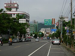
On 1 July 1957, the Zhongxing New Village in Nantou Township was designated as the capital of Taiwan Province, replacing the former capital Taipei. It remained the capital until the province was reorganized in 1997.[3]:1[17] Construction of Zhongxing New Village began in 1956, and it was intended to be a model of Chinese rule and represent a vision for the future.[10]:16 The location was chosen both for its centrality and for its relatively security from invasion, although it was a second choice after a location in Taichung County.[10]:115 The move of the government occurred before the new site was ready, leading many departments needing to find temporary accommodation. Many employees were unhappy with the move, as the new Nantou County location was seen as quiet and remote.[10]:117 The remoteness also created logistical issues, including there not being enough food to feed all the newly translocated government employees.[10]:121 In 1981, the county seat was upgraded from Nantou Township to Nantou City.
Under the Republic of China, some areas assigned to the Thao by Japanese authorities were retaken by the state.[4]:163 Indigenous people were assigned reserves, however these sometimes overlapped with otherwise restricted areas. For example, 758 hectares (1,870 acres) of the 1,169 hectares (2,890 acres) within Xinyi fell within the Yushan National Park.[4]:128–129 One Bunun village that fell within Yushan National Park had its traditional graves extracted to enhance the park.[4]:131 A land registration program in 1964 favored Chinese settlers, and many Thao who either did not know they needed to register or could not afford to ended up as tenants on state land. Other Thao land was appropriated for tourism purposes. A ring road built around Sun Moon Lake in 1969 increased immigration and tourism. The Sun Moon lake area was declared protected in 1970, however this policy did not provide land to the Thao people.[4]:163–165
In 1960 Sun Hai[zh] founded a logging company in Checheng, which quickly expanded and revitalized the town.[5]:29 However, the government banned logging in 1985. While the industry attempted to shift to processing imported wood, the forestry sector declined.[13]
In the 1970s road transport improvements included the opening of Provincial Highway 16. Rail transport decreased. The Jiji line was considered for closure in 1986, however it was reopened as a tourist railway. Tourism proved a success, and in the 1990s the line saw 1,000 tourists every weekend.[19] Railway tourists brought a new economic lease of life to the declining towns along the railway.[13]
The new authorities built more tourism sites at Sun Moon Lake, and in 1992 declared it a special 1,974 hectares (4,880 acres) development area.[5]:10 While the pottery industry had declined with the arrival of plastic products, some kilns such as the Shuili Snake Kiln were recontextualized as educational and entertainment facilities.[5]:29
After the provincial government of Taiwan Province was removed due to streamlining, Zhongxing New Village began to decay,[10]:16 although it remains the official administrative center.[10]:65
The 1999 Jiji earthquake struck the region at 1:47am on 21 September. Measuring 7.3 on the Richter scale, it caused substantial damage to infrastructure and loss of life.[17] 136 schools were rebuilt.[20] The Thao community organized to assist in reconstruction, and also pushed for reconstruction to be done in a way that restored their culture. In 2001, the Thao people were recognized as Taiwan's 10th indigenous group.[4]:173–174
Following the earthquake, the area around Sun Moon Lake was reorganized under the Tourism Bureau, with the Sun Moon Lake National Scenic Area created on 24 January 2000. This new body was tasked with both reconstruction and expanding tourism to the area.[5]:2
In 2001, Typhoon Toraji brought 650 millimetres (26in) of rainfall, causing landslides and flooding.[21]
Geography
Hehuanshan is one of the higher mountains in Nantou County.
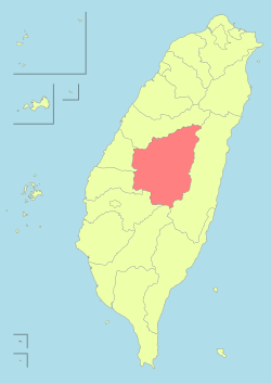
Nantou County has an area of 4,106.436km2 (1,585.504sqmi) with a width of 72km (45mi) and length of 95km (59mi). It is the second largest county in Taiwan after Hualien County.[22] Located at the middle of the island,[3]:2 its borders are about 25 kilometres (16mi) from the eastern and western coasts and 100 kilometres (62mi) from the north and south of the island. The geographic center of Taiwan is on Mount Hutou[zh], in the Puli township.[3]:4 It is the only landlocked county in Taiwan, bordering Taichung County on its north, Hualien County to the east, Chiayi County and Kaohsiung to the south, and Changhua County and Yunlin County to the west.[3]:1 Many of these borders follow natural features. The western border lies on the Bagua Plateau, while the eastern border lies along the Central Mountain Range. The north and south borders also follow watersheds.[3]:4
There are 41 mountains taller than 3,000 metres (9,800ft).[23] The tallest is Yu shan in Xinyi Township, the highest peak in Taiwan with a height of 3,952 metres (12,966ft).[24] Around 83% of Nantou County area is covered by hills and mountains.[23] Large areas of forest and wilderness remain in the mountains. Between some of the mountains lie the Puli Basins.[3]:4 These basins, while limited by surrounding mountains, are large areas of flat terrain that is conducive to agriculture.[3]:10
The mountainous geography of the county has created multiple climatic zones.[3]:2 The annual average temperature is 23°C (73°F) on level ground and 20°C (68°F) on mountains. The annual average rainfall is less than 1,750mm (68.9in) in non-mountainous areas and 2,800mm (110.2in) in mountainous areas. The rainy season lasts from April to September and the dry season lasts from October to March.[22] Historically water shortages have occurred in the spring and autumn, similar to the Chiayi–Tainan Plain. In 1925, Puli went 151 days without rain.[3]:4
Local government is led by the Magistrate of Nantou County, who is elected and limited to two four-year terms.[3]:18 Since the position was first filled on 1 June 1951, the majority of its officeholders have been members of the Kuomintang party.[3]:19–22 The incumbent is Hsu Shu-hua of the Kuomintang.[30]
Elections in Nantou County for representation in the Legislative Yuan and for county-wide offices are generally won by Kuomintang (KMT) candidates.[33] While there are no county-wide KMT factions, there is internal factional politics at the town and city level.[34]
The largest population of Atayal people is in Ren'ai. Many Bunun people live in Ren'ai and Xinyi. Xinyi also has a distinct Tsou population. The Yuchi and Shuili townships are home to the Thao people.[3]:5 The Thao were recognized as separate from the Tsou only in 2001, and less than 1,000 people are registered as Thao.[4]:54 The Seediq are divided into three dialect groups, the Truku,[a] Teuda, and Tkedaya, each with roughly equal populations. These were historically antagonistic groups, up until at least some time during the Japanese period. The Nantou Seediq have a mixed relationship with Seediq in neighboring Hualian County, with views stretching from viewing them as part of the same dialect groups to asserting that they should be viewed as a different ethnic group entirely.[8]:87
The population growth and decline is calculated by subtracting the population of the previous month from the current month's population. Negative values are represented by red letters, positive values are represented by blue letters, and no growth is represented by green letters.
The population density of each district is calculated by rounding 4 to 5 to 1 decimal place
Due to its landlocked nature, the county's economy depends mainly on agriculture.[18][39] Other important industries in the county include forestry, fishery, and animal husbandry. Tourism and manufacturing are also important.
As of 2016, there are 28,000 registered businesses and 5,205 registered companies in the county with a total capital of NT$5,609 million and NT$80,024 million respectively. There are 938 factories operating in the county as of 2015.[40]
Many areas along the Jiji line are still agricultural. While banana production has decreased from historical levels, other crops include dragon fruit and oranges.[12]:45 The Jiji line has also proved a significant tourism draw, going through picturesque countryside. A railway museum has been opened at its terminus.[19]Assam tea is cultivated around Sun Moon Lake. This tea was first introduced the area by the Japanese. Also grown around the lake are mushrooms and orchids. Plums are grown in Shuili, which also serve as a tourist attraction when they blossom in December. The plums are processed into various products, including dry fruit, vinegar, and wine.[5]:25Dong Ding tea is cultivated in Lugu. A unique variation, Gui Fei Oolong, was developed after the 1999 Jiji earthquake. It is created from tea leaves that secrete honey-flavored defences against Jacobiasca formosana insects.[41]
Sun Moon Lake also supports a small fishery, holding sharpbelly and predatory carp. Sharpbelly are a traditional part of the Thao diet. As the fish are small, it is common to salt or deep fry them. Predatory carp are larger, reaching 30 centimetres (12in). They became known as "President's Fish" as Chiang Kai-shek was known to eat them whenever visiting the lake.[5]:30
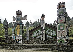
The Nantou government has sought to encourage international as well as domestic tourism. It has also sought to develop industrial parks in Zhongxing New Village,[40] and is developing similar industrial parks elsewhere.[37]:21 Events held by the government include a lantern festival, a Coffee and Chocolate Festival, a tea expo, and the Sun Moon Lake Swimming Carnival.[37]:3,17Huhuanshan was certified as a Dark-sky preserve by DarkSky International in 2019, the first Dark-sky preserve in Taiwan.[37]:1 A tourist shuttle bus network connects many key points within the county.[37]:23 Old logging buildings in Checheng have been preserved for tourists.[5]:29 The Formosan Aboriginal Culture Village is a joint amusement park and education center for all the Taiwanese indigenous peoples.[5]:30
As of 2007, there were 2 colleges, 13 senior high and vocational schools, 30 junior high schools, 149 elementary schools, 106 kindergartens, and 84 day care centers in the county.[42] This changed to 2 colleges, 15 high schools, 23 junior high school schools, 139 elementary schools, and 180 kindergartens in January 2024.[43] In preschools linked to elementary schools, there is a student-teacher ratio of 12:1.[37]:5 Since 2005, students from third grade up are required to take at least on English class each week. The county operates one community college, distributed through 10 branches.[20] Notable universities in the county are National Chi Nan University, National Chung Hsing University and Nan Kai University of Technology.
An Indigenous Community College has been established by the government to help create locally-generated curriculumns that reflect traditional cultures.[37]:11
The Taiwanese indigenous peoples in the county retain many distinct customs.[3]:5 In many cases these are retained from previous homelands, following migration to the Puli basin in the 19th century.[6]:37
Different Plains Indigenous peoples with communities in the Puli basin have different ceremonies as part of ancestor worship. The Papora people hold an annual ancestor worship ceremony at the start of the seventh month in the lunar calendar, called the "Alomai". This ceremony has never been open to those outside of the community. The Taokas people hold the "Chian Tien" ritual from the 15th day of the seventh month to the 15th day of the eighth month. For this, three large flags are created. On the final day, the flags are each assigned their own flag bearer and two guards for a ritual march, and a flag falling indicates misfortune. The Babuza people similarly celebrate "Chian Tien", but within their households rather than on a community basis. Arikun and Lloa communities celebrate on the 20th day of the seventh month. Their rituals take place in front of a sacred Bischofia javanica tree.[6]:38
The Pazeh and Kaxabu communities celebrate "Azem" on the 15th day of the 11th month.[6]:38
However, many groups share a common practice of offering rice cakes as part of ancestor worship, although different names are used by each group.[6]:37
1234567891011Scott Simon (2015). "Making Natives: Japan and the Creation of Indigenous Formosa". In Andrew D. Morris (ed.). Japanese Taiwan: Colonial Rule and its Contested Legacy. Bloomsbury Publishing. ISBN9781472576743.
↑1.7-鄉鎮市區戶口數[Population for Township and District]. Ministry of the Interior (in Chinese (Taiwan) and English). August 2020. Retrieved 21 September 2020. 南投縣 Nantou County南投市 Nantou City埔里鎮 Puli Township草屯鎮 Caotun Township竹山鎮 Jhushan Township集集鎮 Jiji Township名間鄉 Mingjian Township鹿谷鄉 Lugu Township中寮鄉 Jhongliao Township魚池鄉 Yuchih Township國姓鄉 Guosing Township水里鄉 Shueili Township信義鄉 Sinyi Township仁愛鄉 Renai Township
↑"Profile of Nantou County". Nantou County Government. 7 January 2015. Archived from the original on 19 November 2017. Retrieved 25 May 2019. Language: Mandarin is the official language; Taiwanese, Hakka, English and dialects of aborigines are also spoken.
1 Provinces are merely formal entities within the constitutional structure, and have no governing power after the dissolution of their administrative organs in 2018. Cities and counties are the de facto principal administrative divisions of Taiwan.
Sarah Shair-Rosenfield (November 2020). "Taiwan Combined"(PDF). University of North Carolina at Chapel Hill. Retrieved 29 May 2021.
This page is based on this Wikipedia article Text is available under the CC BY-SA 4.0 license; additional terms may apply. Images, videos and audio are available under their respective licenses.


![The 2023 Nantou County 2nd Constituency by-election [zh] saw the election of a Democratic Progressive Party legislator, rare in the county 2023 Nantou County Constituency 2 By-election Result Map.svg](http://upload.wikimedia.org/wikipedia/commons/thumb/3/3b/2023_Nantou_County_Constituency_2_By-election_Result_Map.svg/250px-2023_Nantou_County_Constituency_2_By-election_Result_Map.svg.png)