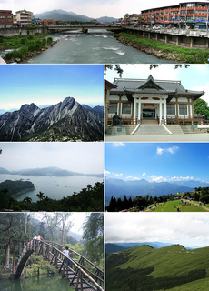
Nantou County is the second largest county of Taiwan, located in the central part of the country. It is also the only non-coastal county in Taiwan. Its name derives from the Hoanya Taiwanese aboriginal word Ramtau.

Xinyi District or Sinyi District is the seat of the Taipei City Government and Taipei City Council. The district includes Taipei 101, Taipei International Convention Center, Taipei World Trade Center, National Sun Yat-sen Memorial Hall and various shopping malls and entertainment venues, making it the most cosmopolitan district of Taipei. Xinyi District is also considered the financial district of Taipei.
Highways in Taiwan are classified into five types:
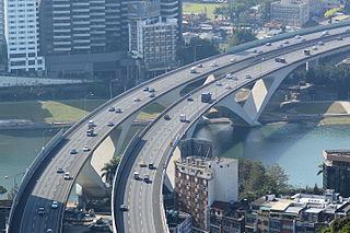
National Freeway 3, also known as Formosa Freeway, is a freeway in Taiwan. It is the second north–south freeway in Taiwan, beginning in Keelung City at Jijin Interchange on the provincial highway 2 and ending in Linbian, Pingtung on the provincial highway 17. It is the longest freeway in Taiwan with the total length of 430.5 km (267.5 mi). The freeway is also the only one in the national freeway system with a spur route, Freeway 3A.

Provincial Highway 64 is a 28.42-kilometre-long (17.66-mile) expressway in Taiwan entirely within the limits of New Taipei City. Also known as East-West Expressway, Bali-Xindian Line, the route begins in Port of Taipei in Bali District and ends near the west approach of Xiulang Bridge in Zhonghe District, linking many major population centers within New Taipei together, including Sanchong, Banqiao, and Zhonghe. It is one of the twelve east-west expressways of western Taiwan linking Freeways 1 and 3.

The Taitung Line, also known as the Hua-Tung line, is the southern section of the Eastern Line of the Taiwan Railways Administration. The line starts at the Hualien station and ends at the Taitung station. It is 161.5 km long, including the main segment of 155.7 km between Hualien and Taitung.

Alishan Forest Railway is an 86 km network of 2 ft 6 in narrow gauge railways running up to and throughout the popular mountain resort of Alishan in Chiayi County, Taiwan. The railway, originally constructed for logging, has become a tourist attraction with its unique Z-shaped switchbacks, and over 50 tunnels and 77 wooden bridges. Taiwan's Ministry of Culture has listed the forest railway as a potential World Heritage Site.
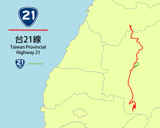
Taiwan Provincial Highway No. 21 is a Provincial Highway in Taiwan that begins Tianleng (天冷), Dongshi District, Taichung City, at the intersection with Provincial Highway No. 8, and ends at Tataka(塔塔加), where it is connected with Provincial Highway No. 18 in Yushan National Park. It is the primary highway to the Sun Moon Lake, a popular tourist destination. The total length is 145 km.

Fenglin Township, is an urban township in central Hualien County, Taiwan. It is located in Huatung Valley bordering Shoufeng Township on the north and Guangfu Township on the south. It has a population of around 11,237 inhabitants in 12 villages.

Taiwan Provincial Highway No. 18 is a highway between Taibao in Chiayi County to Provincial Highway No. 21 at Tatajia (Tataka) in Yushan National Park. It is also called the New Central Cross-Island Highway(新中橫公路) and Alishan Highway(阿里山公路). The highway connects Chiayi City and the rest of Western Taiwan to Alishan National Scenic Area and Yushan National Park. The overall length of the highway is 108.559 km.
Provincial Highway 1 is a 461.081 km (286.502 mi)-long Taiwanese provincial highway that starts in the north of the country near Taipei Main Station and ends in the south at Fangshan, Pingtung County. It intersects with Provincial Highway 9 and Provincial Highway 26. Before the freeway system was built in Taiwan, this was the primary north-south highway for the island. The highway connects most of the major cities in Taiwan. In most parts of Taiwan, the road is known as The North-South Highway (縱貫公路).

Provincial Highway No. 9 is an important highway across eastern Taiwan from Taipei City to Fangshan, Pingtung, Pingtung County. This provincial highway, at 476.1 km long, is the longest provincial highway in Taiwan and passes the regions of Taipei City, New Taipei City, Yilan County, Hualien County, Taitung County and Pingtung County.

Provincial Highway No. 2 (台2線) is an east-west, 167.674 km-long provincial Taiwanese highway that starts from the border of Taipei and Tamsui and ends in Su'ao, Yilan. Although designed as an east-west route, the highway actually goes in north-south direction in Yilan County and parts of New Taipei City. The highway serves as the primary road for the north coast cities in Taiwan.

Provincial Highway 3 is a 435.608 km-long Taiwanese highway that starts in Taipei and ends in Pingtung. Also known as Inner-Mountain Highway (內山公路), the road travels through the mountain towns in Western Taiwan and was the major route for the area until NH 3 was built.

Wanrong Township or Wanrung Township is a mountain indigenous township located in the west of Hualien County, Taiwan, and has a population of 6,530 inhabitants and 8 villages.

Provincial Highway 7 is a highway connecting Daxi, Taoyuan and Zhuangwei, Yilan. The highway is also known as Northern Cross-Country Highway, one of the three most important east–west highways in Taiwan.

Provincial Highway 14 is an east–west highway that connects Changhua City in Changhua County with Ren'ai, an aboriginal township in Nantou County. The highway is known as Zhongtan Highway (中潭公路) from Caotun to Puli, and Puwu Highway from Puli to Ren'ai. The total length is 99.0 kilometers.

The Lintianshan Forestry Culture Park is a former lumber town in Fenglin Township, Hualien County, Taiwan.

Batongguan Historic Trail is the name of two trails crossing the Central Mountain Range from Zhushan, Nantou to Yuli, Hualien in Taiwan. The first iteration of the trail was built in the Qing Dynasty and was abandoned; a second was built in the Japanese era. Both were built for the government to control the indigenous population living in the mountains. Though the two trails rarely overlap, they are often referred to by the same name.

