Taroko National Park is one of the nine national parks in Taiwan and was named after the Taroko Gorge, the landmark gorge of the park carved by the Liwu River. The park spans Taichung Municipality, Nantou County, and Hualien County and is located in Xiulin Township, Hualien County, Taiwan.

Hualien County is a county on the east coast of Taiwan. It is Taiwan's largest county by area, yet due to its mountainous terrain, has one of the lowest populations in the country. The county seat and largest city is Hualien City.

Taiwan railway Railways Administration (TRA) is a railway operator in Taiwan. It is an agency of the Ministry of Transportation and Communications, responsible for managing, maintaining, and running conventional passenger and freight railway services on 1,097 km (682 mi) of track in Taiwan.
Highways in Taiwan are classified into five types:
National Freeway 3, also known as Formosa Freeway, is a freeway in Taiwan. It is the second north–south freeway in Taiwan, beginning in Keelung City at Jijin Interchange on the provincial highway 2 and ending in Linbian, Pingtung on the provincial highway 17. It is the longest freeway in Taiwan with a total length of 431.5 km (268.1 mi). The freeway is also the only one in Taiwan to have a spur route, Freeway 3A.
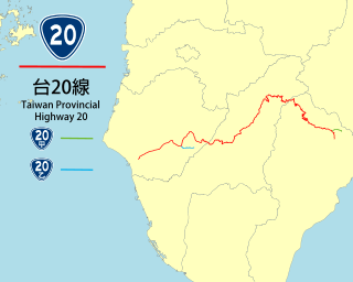
The Southern Cross-Island Highway, also known as Provincial Highway No. 20, links Tainan City on the west coast to Taitung City on the east coast, on the southern section of the island of Taiwan. The road is 209 kilometres (130 mi) long.

Mount Hehuan is a 3,416-metre-high (11,207 ft) mountain in Central Taiwan. The peak lies on the borders of Nantou and Hualien counties and is located within Taroko National Park. Hehuanshan is a popular destination in central Taiwan. The 3,421-metre east peak and 3,422-metre north peak of Hehuanshan are both higher than the main peak.

Heping District (Chinese: 和平區; pinyin: Hépíng Qū; Wade–Giles: Ho2-p'ing2 Ch'ü1) is a mountain indigenous district in eastern Taichung, Taiwan, and it is the largest district of Taichung City. It is also the largest district in Taiwan by area. It is the geographic center of Taiwan.

Provincial Highway 9 is an important highway across eastern Taiwan from Taipei City to Fangshan, Pingtung, Pingtung County. This provincial highway, at 453.851 km long, is the second-longest provincial highway in Taiwan and passes the regions of Taipei City, New Taipei City, Yilan County, Hualien County, Taitung County and Pingtung County.

Provincial Highway No. 2 (台2線) is an east-west, 167.674 km-long provincial Taiwanese highway that starts from the border of Taipei and Tamsui and ends in Su'ao, Yilan. Although designed as an east-west route, the highway actually goes in north-south direction in Yilan County and parts of New Taipei City. The highway serves as the primary road for the north coast cities in Taiwan.
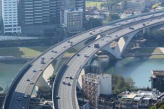
Taipei Bridge is a motor-vehicle bridge across the Tamsui River connecting Taipei with Sanchong District, New Taipei City in Taiwan. A central span carries automobile and some motorcycle traffic while narrower spans on either side carry most motorcycle traffic along with bicycle pedestrian traffic. The central bridge is 481.6 meters in length.
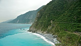
The Suhua Highway, also called the Suao-Hualien Highway, is a 118-kilometre (73 mi) section of the Provincial Highway 9 in Taiwan, starting at Su'ao Township, Yilan County and ending at Hualien City, Hualien County. With a portion built alongside very steep cliffs high above the Pacific Ocean, it is considered to be one of Taiwan's most dangerous but also most scenic drives. Famous stops along the way include the Qingshui Cliffs and Taroko Gorge, located at the southern end of the highway.

Guguan Hot Spring is a hot spring located in Heping District, Taichung, Taiwan. It is accessible from Provincial Highway 8. It was previously named Meiji Onsen.

Provincial Highway 7 is a highway connecting Daxi, Taoyuan and Zhuangwei, Yilan. The highway is also known as Northern Cross-Country Highway, one of the three most important east–west highways in Taiwan.

Provincial Highway 14 is an east–west highway that connects Changhua City in Changhua County with Ren'ai, an aboriginal township in Nantou County. The highway is known as Zhongtan Highway (中潭公路) from Caotun to Puli, and Puwu Highway from Puli to Ren'ai. The total length is 99.0 kilometers.

Wuling, formerly known as Sakuma Pass, is a mountain pass located in Ren'ai, Nantou, Taiwan, transversing the Central Mountain Range near the peak of Hehuanshan within Taroko National Park. It is the highest paved road in elevation in Taiwan.

Dayuling, formerly Hehuan Pass, is a mountain pass in Taiwan transversing the Central Mountain Range between Hehuanshan and Mt. Bilu (畢祿山), within Taroko National Park. Administratively, it is located in Xiulin, Hualien County near the border with Nantou County.

Yakou, also known as Guanshan Pass or Daguanshan Pass, is a mountain pass in Taiwan transversing the Central Mountain Range within Yushan National Park. The name Yakou literally means "mountain pass". At the peak, there is a short, one-way named the Daguanshan Tunnel, which is the highest tunnel in Taiwan. Administratively, it is located at the border of Taoyuan, Kaohsiung and Haiduan, Taitung.

Tri-Mountain National Scenic Area is a national scenic area located within central Taiwan, spanning Hsinchu County, Miaoli County, Taichung City, Changhua County, and Nantou County. The area is composed of three non-contiguous scenic areas, which are all named after mountains, hence the name.

Batongguan Historic Trail is the name of two trails crossing the Central Mountain Range from Zhushan, Nantou to Yuli, Hualien in Taiwan. The first iteration of the trail was built in the Qing dynasty and was abandoned; a second was built in the Japanese era. Both were built for the government to control the indigenous population living in the mountains. Though the two trails rarely overlap, they are often referred to by the same name.