
Xinyi District or Sinyi District is the seat of the Taipei City Government and Taipei City Council. The district includes Taipei 101, Taipei International Convention Center, Taipei World Trade Center, National Sun Yat-sen Memorial Hall and various shopping malls and entertainment venues, making it the most cosmopolitan district of Taipei. Xinyi District is also considered the financial district of Taipei.
Highways in Taiwan are classified into five types:
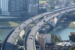
National Freeway 3, also known as Formosa Freeway, is a freeway in Taiwan. It is the second north–south freeway in Taiwan, beginning in Keelung City at Jijin Interchange on the provincial highway 2 and ending in Linbian, Pingtung on the provincial highway 17. It is the longest freeway in Taiwan with the total length of 430.5 km (267.5 mi). The freeway is also the only one in the national freeway system with a spur route, Freeway 3A.

Provincial Highway 64 is a 28.42-kilometre-long (17.66-mile) expressway in Taiwan entirely within the limits of New Taipei City. Also known as East-West Expressway, Bali-Xindian Line, the route begins in Port of Taipei in Bali District and ends near the west approach of Xiulang Bridge in Zhonghe District, linking many major population centers within New Taipei together, including Sanchong, Banqiao, and Zhonghe. It is one of the twelve east-west expressways of western Taiwan linking Freeways 1 and 3.

Provincial Highway No. 61 is usually known as West Coast Expressway (西部濱海快速公路). The highway runs along the west coast of Taiwan. Several sections of the highway are freeway standards with no at-grade intersections, while the rest are local highway standards. There are several sections open for the traffic. Others are still under construction.

The Civic Boulevard is a 4 to 6-lane highway located in Taipei, Taiwan. It was completed in 1997 as part of a multi-modal reconstruction project to improve transportation networks in congested central Taipei. The highway begins at the MacArthur Bridges in the east (connecting the Neihu district, and Keelung Road, heads west to an interchange with the Zhongxiao Bridge and the HuanHe Expressway, providing direct access to Taipei Main Station, which is just south of the Civic Blvd. Expressway in the Zhongzheng district. Since Civic Blvd. is elevated, there is also a surface-level frontage road system below the highway, connecting intersecting arterials with highway ramps. As part of the larger project, the elevated Civic Blvd. Expressway was constructed to provide a new, east–west highway through Taipei, moving the Taipei railway railroad tracks underground to reduce congestion at surface railroad crossings, and providing new underground parking options. Other additions to this project constructed new underground shopping malls in the vicinity of Taipei Main Station and provisions for utilities. In the future, tracks for the Taiwan High Speed Rail system will be added under existing tracks for the THSR's extension to Nangang in 2012.

Zhongxiao Road is a major arterial boulevard and part of provincial highway 5 in Taipei, Taiwan, connecting the Zhongzheng district in the west with the Daan, Songshan, Xinyi, and Nangang districts towards the east. Zhongxiao is known as a popular shopping and entertainment area, with many large department stores and shopping malls located along most of the entire stretch. About half of the Nangang Line of the Taipei Metro runs under the road, with stations located at major intersections along the road, which accounts for the significant pedestrian traffic along the road. The majority of the road is 8-10 lanes wide with a median dividing the road. At the intersection with Zhongshan Road, there is a two-lane underpass for traffic on Zhongxiao Road to bypass the intersection.

Keelung Road is a major arterial and highway in Taipei, Taiwan, connecting the Neihu district from the MacAuthur 1st Bridge in the east with the Songshan, Xinyi, and Daan districts towards the southwest, with a connection to Yonghe City via the Fuhe Bridge. Keelung is a very congested route because of its connections to and from Huandong Blvd., Tiding Blvd., Civic Blvd Expressway, Xinhai Road/National Freeway No. 3A, Shuiyuan Expressway, and the Fuhe Bridge, which are all major transportation corridors. There are a series of reversible lanes and bypasses along the corridor to provide traffic relieve within the small right-of-way.
Provincial Highway 1 is a 461.081 km (286.502 mi)-long Taiwanese provincial highway that starts in the north of the country near Taipei Main Station and ends in the south at Fangshan, Pingtung County. It intersects with Provincial Highway 9 and Provincial Highway 26. Before the freeway system was built in Taiwan, this was the primary north-south highway for the island. The highway connects most of the major cities in Taiwan. In most parts of Taiwan, the road is known as The North-South Highway (縱貫公路).

Xizhi is an inner city district in New Taipei City in northern Taiwan, and is located between Taipei City and Keelung City.

Provincial Highway No. 9 is an important highway across eastern Taiwan from Taipei City to Fangshan, Pingtung, Pingtung County. This provincial highway, at 476.1 km long, is the longest provincial highway in Taiwan and passes the regions of Taipei City, New Taipei City, Yilan County, Hualien County, Taitung County and Pingtung County.

Provincial Highway 11, also known as Hualien-Taitung Coastal Highway for its connection between Hualien County and Taitung County is located on the east coast of Taiwan. This highway, which is 178.229 km, begins in Hualien City and ends in Taitung City. It also has 3 branch lines. The East Coast National Scenic Area and Farglory Ocean Park are also located on this highway. It was called Tōkaidō during Japanese rule period.

Provincial Highway No. 2 (台2線) is an east-west, 167.674 km-long provincial Taiwanese highway that starts from the border of Taipei and Tamsui and ends in Su'ao, Yilan. Although designed as an east-west route, the highway actually goes in north-south direction in Yilan County and parts of New Taipei City. The highway serves as the primary road for the north coast cities in Taiwan.

Provincial Highway 3 is a 435.608 km-long Taiwanese highway that starts in Taipei and ends in Pingtung. Also known as Inner-Mountain Highway (內山公路), the road travels through the mountain towns in Western Taiwan and was the major route for the area until NH 3 was built.
Taiwan Ring Expressway is a proposed, hypothetical expressway encircling the island of Taiwan as part of the National Trunk Highway System of the People's Republic of China. It is not in existence and hypothetical due to the political status of Taiwan. The People's Republic of China claims control over Taiwan while it is administered and controlled by the Republic of China. Taiwan has its own highway system and does not recognize the designation by the People's Republic of China.
MacArthur Thruway, was the first controlled-access highway in Taiwan, linking Taipei to Keelung from 1964 to 1977. It was a predecessor to the Republic of China's National Highway System.

Provincial Highway 7 is a highway connecting Daxi, Taoyuan and Zhuangwei, Yilan. The highway is also known as Northern Cross-Country Highway, one of the three most important east–west highways in Taiwan.

Provincial Highway 15 is a north–south highway that connects Tamsui in New Taipei City with Hsinchu City. The highway is known as Xibin Highway (西濱公路) for the entire stretch. The highway runs along the coasts of northwestern Taiwan. The total length is 83.9 kilometres.
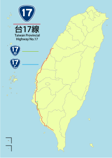
Provincial Highway 17 (PH 17), Chinese: 台17線) is a north–south highway from Qingshui in Taichung City to Fangliao in Pingtung County. The highway is known as Western Coastal Highway (西部濱海公路) since it runs parallel to the western coasts of Taiwan. Since the completion of PH 61 expressway, which parallels PH 17, the latter now mostly handles local traffic. The total length of the highway is 273.474 kilometres (169.929 mi).

Provincial Highway 19 is a north–south highway from Changhua City in Changhua County to Yongkang in Tainan City. The highway is known as Central Highway (中央公路). The highway lies between the coastal PH 17 and the inland PH 1 which serves many of the major cities in central and southern Taiwan. The total length of the highway is 140.195 kilometres (87.113 mi).


