Western Trunk line

Last updated • 2 min readFrom Wikipedia, The Free Encyclopedia
Western Trunk line
Taiwan Railway Route English.gif
Western Trunk line in blue
Overview
Native name西部幹線
Termini
Stations134
Service
TypeConventional railway
Operator(s) Taiwan Railway Corporation
History
Opened10 August 1902
Technical
Line length420.8 km (261.5 mi) [lower-alpha 1]
Number of tracks2 (predominantly)
Track gauge 3 ft 6 in (1,067 mm)
Electrification 25 kV/60 Hz catenary
Operating speed150 km/h (93mph)
Route map

Contents

Station
km
km
Station
BSicon KBHFa.svg
0.0
Keelung
BSicon HST.svg
1.3
Sankeng
BSicon ABZg+l.svg
BSicon CONTfq.svg
(Eastern Trunk line  Arrow Blue Right 001.svg)
BSicon BHF.svg
3.7
Badu
BSicon BHF.svg
6.0
Qidu
BSicon HST.svg
8.7
Baifu
BSicon HST.svg
11.7
Wudu
BSicon BHF.svg
13.1
Xizhi
BSicon HST.svg
14.6
Xike
BSicon tBHFag.svg
19.1
Nangang Taipei Metro Logo(Logo Only).svg
BSicon tBHF.svg
21.9
Songshan Taipei Metro Logo(Logo Only).svg
BSicon tBHF.svg
28.3
Taipei Taipei Metro Logo(Logo Only).svg Taoyuan Metro logo plain.svg Taiwan High Speed Rail Logo(Log Only).svg
BSicon tBHF.svg
31.1
Wanhua
BSicon tBHFef.svg
35.5
Banqiao Taipei Metro Logo(Logo Only).svg
BSicon HST.svg
38.0
Fuzhou
BSicon BHF.svg
40.9
Shulin
BSicon HST.svg
42.9
South Shulin
BSicon HST.svg
44.8
Shanjia
BSicon BHF.svg
49.2
Yingge
BSicon BHF.svg
57.4
Taoyuan
BSicon HST.svg
63.3
Neili
BSicon BHF.svg
67.3
Zhongli
BSicon HST.svg
73.1
Puxin
BSicon HST.svg
77.1
Yangmei
BSicon HST.svg
83.9
Fugang
BSicon HST.svg
85.6
Xinfu
BSicon HST.svg
87.1
Beihu
BSicon HST.svg
89.6
Hukou
BSicon HST.svg
95.8
Xinfeng
BSicon HST.svg
100.6
Zhubei
BSicon ABZg+l.svg
BSicon CONTfq.svg
(Neiwan line  Arrow Blue Right 001.svg)
BSicon HST.svg
105.0
North Hsinchu
BSicon BHF.svg
106.4
Hsinchu
BSicon HST.svg
111.2
Sanxingqiao
BSicon HST.svg
114.4
Xiangshan
BSicon HST.svg
120.8
Qiding
Zhunan
0.0
BSicon BHF.svg
125.4
Zhunan
BSicon bSHI2lr.svg
Tanwen
4.5
BSicon HST.svg
BSicon HST.svg
130.7
Zaoqiao
Dashan
11.2
BSicon HST.svg
BSicon HST.svg
136.6
Fengfu
Houlong
15.0
BSicon HST.svg
BSicon BHF.svg
140.6
Miaoli
Longgang
18.6
BSicon HST.svg
BSicon HST.svg
147.2
Nanshi
Baishatun
26.7
BSicon HST.svg
BSicon HST.svg
151.4
Tongluo
Xinpu
29.8
BSicon HST.svg
BSicon HST.svg
158.8
Sanyi
Tongxiao
35.6
BSicon HST.svg
BSicon HST.svg
169.7
Tai'an
Yuanli
41.7
BSicon HST.svg
BSicon HST.svg
172.3
Houli
Rinan
49.4
BSicon HST.svg
BSicon hBHFa.svg
179.1
Fengyuan
Dajia
54.0
BSicon HST.svg
BSicon hHST.svg
181.6
Lilin
Taichung Port
59.3
BSicon HST.svg
BSicon hHST.svg
184.1
Tanzi
BSicon STR.svg
BSicon hHST.svg
186.0
Toujiacuo
BSicon STR.svg
BSicon hHST.svg
187.7
Songzhu
BSicon STR.svg
BSicon hHST.svg
189.2
Taiyuan
Qingshui
65.3
BSicon HST.svg
BSicon hHST.svg
191.2
Jingwu
Shalu
68.5
BSicon HST.svg
BSicon hBHF.svg
193.3
Taichung
BSicon STR.svg
BSicon hHST.svg
195.3
Wuquan
Longjing
73.1
BSicon HST.svg
BSicon hBHFe.svg
197.5
Daqing
BSicon STR.svg
BSicon HST.svg
200.5
Wuri
Dadu
78.1
BSicon HST.svg
BSicon BHF.svg
201.3
Xinwuri Taiwan High Speed Rail Logo(Log Only).svg
Zhuifen
83.1
BSicon HST.svg
BSicon HST.svg
203.8
Chenggong
BSicon bvvWSLglr.svg
(Arrow Blue Left 001.svg Chengzhui line Arrow Blue Right 001.svg)
Changhua
90.2
BSicon BHF.svg
210.9
Changhua
BSicon HST.svg
217.5
Huatan
BSicon HST.svg
222.1
Dacun
BSicon hBHFae.svg
225.6
Yuanlin
BSicon HST.svg
229.1
Yongjing
BSicon HST.svg
232.8
Shetou
BSicon BHF.svg
237.1
Tianzhong
BSicon BHF.svg
242.9
Ershui
BSicon ABZgl.svg
BSicon CONTfq.svg
(Jiji line  Arrow Blue Right 001.svg)
BSicon HST.svg
251.0
Linnei
BSicon HST.svg
255.8
Shiliu
BSicon BHF.svg
260.6
Douliu
BSicon BHF.svg
268.2
Dounan
BSicon HST.svg
272.1
Shigui
BSicon HST.svg
276.7
Dalin
BSicon HST.svg
282.5
Minxiong
BSicon HST.svg
289.2
Jiabei
BSicon BHF.svg
291.8
Chiayi
BSicon HST.svg
298.4
Shuishang
BSicon HST.svg
301.0
Nanjing
BSicon HST.svg
307.0
Houbi
BSicon BHF.svg
314.7
Xinying
BSicon HST.svg
318.0
Liuying
BSicon HST.svg
321.9
Linfengying
BSicon BHF.svg
327.4
Longtian
BSicon HST.svg
329.6
Balin
BSicon BHF.svg
334.2
Shanhua
BSicon HST.svg
337.1
Nanke
BSicon HST.svg
341.8
Xinshi
BSicon BHF.svg
346.8
Yongkang
BSicon HST.svg
350.5
Daqiao
BSicon BHF.svg
353.2
Tainan
BSicon HST.svg
360.8
Bao'an
BSicon HST.svg
362.2
Rende
BSicon BHF.svg
364.8
Zhongzhou
BSicon ABZgl.svg
BSicon CONTfq.svg
(Shalun line  Arrow Blue Right 001.svg)
BSicon HST.svg
367.7
Dahu
BSicon HST.svg
370.6
Luzhu
BSicon BHF.svg
378.4
Gangshan Kaohsiung Mass Rapid Transit Logo(Logo Only).svg
BSicon HST.svg
382.0
Qiaotou Kaohsiung Mass Rapid Transit Logo(Logo Only).svg
BSicon BHF.svg
386.2
Nanzi
BSicon BHF.svg
391.3
Xinzuoying Kaohsiung Mass Rapid Transit Logo(Logo Only).svg Taiwan High Speed Rail Logo(Log Only).svg
BSicon tHSTag.svg
393.2
Zuoying
BSicon tHST.svg
394.4
Neiwei
BSicon tHST.svg
396.1
Museum of Fine Arts
BSicon tHST.svg
397.3
Gushan
BSicon tHST.svg
399.0
Sankuaicuo
BSicon tBHF.svg
399.8
Kaohsiung Kaohsiung Mass Rapid Transit Logo(Logo Only).svg
BSicon tHST.svg
401.2
Minzu
BSicon tHST.svg
402.2
Sci-tech Museum
BSicon tHST.svg
404.0
Zhengyi
BSicon tBHFef.svg
405.6
Fengshan
BSicon HST.svg
409.3
Houzhuang
BSicon HST.svg
413.6
Jiuqutang
BSicon HST.svg
418.6
Liukuaicuo
BSicon hBHFa.svg
420.8
Pingtung
BSicon hCONTf.svg
(Arrow Blue Down 001.svg  South-link line)

Western Trunk line (Chinese :縱貫線; pinyin :Zòngguàn xiàn; Pe̍h-ōe-jī :Chhiòng-koàn sòaⁿ) is a railway line of Taiwan Railway in western Taiwan. [1] [2] It is by far the busiest line, having served over 171 million passengers in 2016. The total length of the line is 404.5 km (251.3 mi).

The line is an official classification of physical tracks and does not correspond to particular services. It is connected to Taichung line (mountain line; 山線) at Zhunan and Changhua. Many services turn inland to take the Taichung route, then reconnect back to the main line (West Coast line). Train schedules and departure boards mark either mountain or coastal (海線) line to indicate the route taken.

History

The original railroad between Keelung and Twatutia was completed in 1891. The section between Twatutia and Hsinchu was finished in 1893. However, in the Japanese era, these sections were all rebuilt by the Government-General of Taiwan as part of its Taiwan Trunk Railway (縱貫鐵道, Jūkan Tetsudō) project. The Taiwan Trunk Railway was completed in 1908 with route from Kīrun (基隆, Keelung) through Taihoku (臺北, Taipei), Shinchiku (新竹, Hsinchu), Taichū (臺中, Taichung), Tainan (臺南, Tainan), to Takao (高雄, Kaohsiung).

The Taiwan Trunk Railway at that time went through all major cities in western Taiwan. However, the terrain around Taichū (Taichung) created a significant bottleneck for rail freight transport. To resolve this issue, the Government-General of Taiwan decided to build a Coastal Line (海岸線, Kaigan-sen) between Chikunan (竹南, Zhunan) and Shōka (彰化, Changhua) to relieve the congestion. The construction of the Coastal Line was started in 1919 and completed in 1922. The Coastal Line then became a part of the main West Coast Line, and the original railway through Taichū (Taichung) was named as a separate line (Taichung line).

Due to service patterns, the following lines are often collectively referred to as the Western main line (Chinese :西部幹線; Pe̍h-ōe-jī :Se-pō͘ Kàn-sòaⁿ)

NameChinese Taiwanese Hakka LengthTerminus
West Coast line縱貫線Chhiòng-koàn SòaⁿChiúng-kon Sien404.5 km (251.3 mi)from Keelung to Kaohsiung
Taichung line 臺中線Tâi-tiong SòaⁿThòi-chûng Sien85.5 km (53.1 mi)from Zhunan to Changhua (via Taichung)
Pingtung line 屏東線Pîn-tong SòaⁿPhìn-tûng Sien61.3 km (38.1 mi)from Kaohsiung to Fangliao

Stations

NameChinese Taiwanese Hakka Transfers and NotesLocation
Keelung 基隆Ke-lângKî-lùng Ren'ai Keelung
Sankeng 三坑Saⁿ-kheⁿSâm-hâng
Badu 八堵Peh-tó͘Pat-tú Taiwan Railways Administration Logo plain.svg Yilan line Nuannuan
Qidu 七堵Chhit-tó͘Chhit-tú Qidu
Baifu 百福Pah-hokPak-fuk
Wudu 五堵Gō͘-tó͘Ńg-tú Xizhi New Taipei
Xizhi 汐止Se̍k-chíSip-chṳ́
Xike 汐科Se̍k-khoSip-khô
Nangang 南港Lâm-kángNàm-kóng Taiwan High Speed Rail Logo(Log Only).svg Nangang
Taipei Metro Logo(Logo Only).svg Taipei Metro Line BL.svg Nangang
Nangang Taipei
Songshan 松山Siông-sanChhiùng-sân Taipei Metro Logo(Logo Only).svg Taipei Metro Line G.svg Songshan Songshan
Taipei 臺北Tâi-pakThòi-pet Taiwan High Speed Rail Logo(Log Only).svg Taipei
Taipei Metro Logo(Logo Only).svg Taipei Metro Line R.svg Taipei Metro Line BL.svg Taipei Main
Taoyuan Metro logo plain.svg Taoyuan Metro Line Airport.svg Taipei Main (200m)
Zhongzheng
Wanhua 萬華Bān-hôaVan-fà Taipei Metro Logo(Logo Only).svg Taipei Metro Line BL.svg Longshan Temple Wanhua
Banqiao 板橋Pang-kiôPán-khiâu Taiwan High Speed Rail Logo(Log Only).svg Banqiao
Taipei Metro Logo(Logo Only).svg Taipei Metro Line BL.svg Banqiao
Banqiao New Taipei
Fuzhou 浮洲Phû-chiuFeù-chû
Shulin 樹林Chhiū-nâSu-lìm Shulin
South Shulin 南樹林Lâm-chhiū-nâNàm Su-lìm
Shanjia 山佳Soaⁿ-á-khaSân-kâ
Yingge 鶯歌Eng-koYîn-kô Yingge
Taoyuan 桃園Thô-hn̂gThò-yèn Taoyuan Taoyuan
Neili 內壢Lāi-le̍kNui-la̍k Zhongli
Zhongli 中壢Tiong-le̍kChûng-la̍k AB-Kreuz.svg Taoyuan Metro Line Airport.svg Zhongli (u/c)
Puxin 埔心Po͘-simPu-sîm Yangmei
Yangmei 楊梅Iûⁿ-mûiYòng-mòi
Fugang 富岡Hù-kongFu-kông
Xinfu 新富Sin-hùSîn-fu
Beihu 北湖Pak-ô͘Pet-fù Hukou Hsinchu
County
Hukou 湖口Ô͘-kháuFù-khiéu
Xinfeng 新豐Sin-hongSîn-fûng Xinfeng
Zhubei 竹北Tek-pakChuk-pet Zhubei
North Hsinchu 北新竹Pak Sin-tekPet Sîn-chuk Taiwan Railways Administration Logo plain.svg Neiwan line East Hsinchu
Hsinchu 新竹Sin-tekSîn-chuk Taiwan Railways Administration Logo plain.svg Neiwan line
Sanxingqiao 三姓橋Saⁿ-sèⁿ-kiôSâm-siang-khiâu Xiangshan
Xiangshan 香山Hiong-sanHiông-sân
Qiding 崎頂Kiā-téngKhi-táng Zhunan Miaoli
County
Zhunan 竹南Tek-lâmChuk-nàm Taiwan Railways Administration Logo plain.svg Taichung line
Tanwen 談文Tâm-bûnThàm-vùn Zaoqiao
Dashan 大山Tōa-soaⁿThai-sân Houlong
Houlong 後龍Āu-lângHeu-liùng
Longgang 龍港Lêng-kángLiùng-kóng
Baishatun 白沙屯Pe̍h-soa-tūnPha̍k-sâ-thûn Tongxiao
Xinpu 新埔Sin-po͘Sîn-phû
Tongxiao 通霄Thong-siauThûng-siau
Yuanli 苑裡Oán-líYén-lî Yuanli
Rinan 日南Ji̍t-lâmNgit-nàm Dajia Taichung
Dajia 大甲Tāi-kahThai-kap
Taichung Port 臺中港Tâi-tiong-kángThòi-chûng-kóng Qingshui
Qingshui 清水Chheng-chúiChhîn-súi
Shalu 沙鹿Soa-lakSâ-lu̍k Shalu
Longjing 龍井Liông-chéⁿLiùng-chiáng Longjing
Dadu 大肚Tōa-tō͘Thai-tú Dadu
Zhuifen 追分Tui-hunTûi-fûn Taiwan Railways Administration Logo plain.svg Chengzhui line (to Taichung line)
Changhua 彰化Chiong-hoàChông-fa Taiwan Railways Administration Logo plain.svg Taichung line Changhua Changhua
County
Huatan 花壇Hoe-toâⁿFâ-thàn Huatan
Dacun 大村Tāi-chhoanThai-chhûn Dacun
Yuanlin 員林Oân-lîmYèn-lìm Yuanlin
Yongjing 永靖Éng-chēngYún-chhìn Yongjing
Shetou 社頭Siā-thâuSa-theù Shetou
Tianzhong 田中Tiân-tiongThièn-chûng Tianzhong
Ershui 二水Jī-chúiNgi-súi Taiwan Railways Administration Logo plain.svg Jiji line Ershui
Linnei 林內Nâ-lāiLìm-nui Linnei Yunlin
County
Shiliu 石榴Chio̍h-liûSa̍k-liû Douliu
Douliu 斗六Táu-la̍kTeú-liuk
Dounan 斗南Táu-lâmTeú-nàm Dounan
Shigui 石龜Chio̍h-kuSa̍k-kuî
Dalin 大林Tōa-nâThai-lìm Dalin Chiayi
County
Minxiong 民雄Bîn-hiôngMìn-hiùng Minxiong
Jiabei 嘉北Ka-pakKâ-pet East Chiayi
Chiayi 嘉義Ka-gīKâ-ngi AB-Kreuz.svg Taiwan Railways Administration Logo plain.svg Alishan Forest Railway West
Shuishang 水上Chúi-siōngSúi-sông Shuishang Chiayi
County
Nanjing 南靖Lâm-chēngNàm-chhìn
Houbi 後壁Āu-piahHeu-piak Houbi Tainan
Xinying 新營Sin-iâⁿSîn-yàng Xinying
Liuying 柳營Liú-iâⁿLiú-yàng Liouying
Linfengying 林鳳營Lîm-hōng-iâⁿLìm-fung-yàng Lioujia
Longtian 隆田Liông-tiânLùng-thièn Guantian
Balin 拔林Pa̍t-á-nâPha̍t-lìm
Shanhua 善化Siān-hòaSan-fa Shanhua
Nanke 南科Lâm-khoNàm-khô Xinshi
Xinshi 新市Sin-chhīSîn-sṳ
Yongkang 永康Éng-khongYún-không Yongkang
Daqiao 大橋Tōa-kiôThai-khiâu
Tainan 臺南Tâi-lâmThòi-nàm East
Bao'an 保安Pó-anPó-ôn Rende
Rende 仁德Jîn-tekYìn-tet
Zhongzhou 中洲Tiong-chiuChûng-chû Taiwan Railways Administration Logo plain.svg Shalun line
Dahu 大湖Tōa-ô͘Thai-fù Lujhu Kaohsiung
Luzhu 路竹Lō͘-tekLu-chuk
Gangshan 岡山Kong-sanKông-sân Gangshan
Qiaotou 橋頭Kiô-á-thâuKhiâu-thèu AB-Kreuz.svg Kaohsiung MRT Red Line.svg Ciaotou Ciaotou
Nanzi 楠梓Lâm-á-kheⁿNâm-chṳ́ Nanzi
Xinzuoying 新左營Sin-chó-iâⁿSîn-chó-yàng AB-Kreuz.svg Taiwan High Speed Rail Logo(Log Only).svg Zuoying
AB-Kreuz.svg Kaohsiung MRT Red Line.svg Zuoying/THSR
Zuoying
Zuoying–Jiucheng 左營·舊城Chó-iâⁿ (Kū-siâⁿ)Chó-yàng (Khiu-sàng)
Neiwei 內惟Lāi-ûiNui-vì Gushan
Museum of
Fine Arts
美術館Bí-su̍t-koánMî-su̍t-kón
Gushan 鼓山Kó͘-sanKú-sân
Sankuaicuo 三塊厝Saⁿ-tè-chhùSân-khoài-chhṳ̀ Sanmin
Kaohsiung 高雄Ko-hiôngKô-hiùng Taiwan Railways Administration Logo plain.svg Pingtung line
AB-Kreuz.svg Kaohsiung MRT Red Line.svg Kaohsiung Main

Notes

  1. Keelung to Pingtung via Taichung

Related Research Articles

<span class="mw-page-title-main">Taichung</span> Special municipality in Republic of China

Taichung, officially Taichung City, is a special municipality in central Taiwan. Taichung is Taiwan's second-largest city, with more than 2.85 million residents, making it the largest city in Central Taiwan. It serves as the core of the Taichung–Changhua metropolitan area, Taiwan's second-largest metropolitan area.

<span class="mw-page-title-main">Changhua County</span> County in Taiwan Province, Republic of China

Changhua County is the smallest county on the main island of Taiwan by area, and the fourth smallest in the country. With a total population of 1.24 million, Changhua County is the most populous county in the Republic of China. Its capital is Changhua City and it is part of the Taichung–Changhua metropolitan area.

<span class="mw-page-title-main">Miaoli County</span> County in Taiwan Province, Republic of China

Miaoli County is a county in western Taiwan. Miaoli is bordered by Hsinchu County and Hsinchu City to the north, Taichung to the south, and the Taiwan Strait to the west. Miaoli is classified as "central Taiwan" by the National Development Council and "northern Taiwan" by the Taiwan Central Weather Bureau. Miaoli City is the capital of the county, and is also known as "Mountain Town", owing to the number of mountains nearby, making it a destination for hiking.

Highways in Taiwan are classified into five types:

<span class="mw-page-title-main">Taichung line</span> Railway line in Taiwan

The Taichung line, also known as the Mountain line, is a line of the Taiwan Railway. It is one of two parallel lines in Central Taiwan, passing the inland area and Downtown Taichung. It has a total length of 85.5 km (53.1 mi), all of which is double track.

<span class="mw-page-title-main">National Freeway 3</span> Highway in Taiwan

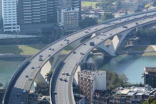
National Freeway 3, also known as Formosa Freeway, is a freeway in Taiwan. It is the second north–south freeway in Taiwan, beginning in Keelung City at Jijin Interchange on the provincial highway 2 and ending in Linbian, Pingtung on the provincial highway 17. It is the longest freeway in Taiwan with a total length of 431.5 km (268.1 mi). The freeway is also the only one in Taiwan to have a spur route, Freeway 3A.

<span class="mw-page-title-main">Provincial Highway 61 (Taiwan)</span> Road in Taiwan

Provincial Highway No. 61, usually known as the West Coast Expressway (西部濱海快速公路), is a highway that runs along the west coast of Taiwan. Several sections of the highway are freeway standards with no at-grade intersections, while the rest are local highway standards. There are several sections open for traffic. Others are still under construction.

<span class="mw-page-title-main">Jiji line</span> Railway line in Taiwan

The Jiji Line is a branch line of the Taiwan Railways Administration, located in Changhua and Nantou Counties in Taiwan. The length of the line is 29.7 km.

<span class="mw-page-title-main">Neiwan line</span> Railway line in Taiwan

The Neiwan line is a railway branch line in Taiwan operated by the Taiwan Railways Administration. It is located in Hsinchu County.

<span class="mw-page-title-main">Transportation in Taichung</span>

Taichung is located in central Taiwan and is the second largest city in the island country.

<span class="mw-page-title-main">Transportation in Taiwan</span>

The Ministry of Transportation and Communications governs transportation in Taiwan.

Provincial Highway 1 is a 461.081 km (286.502 mi)-long Taiwanese provincial highway that starts in the north of the country near Taipei Main Station and ends in the south at Fangshan, Pingtung County. It intersects with Provincial Highway 9 and Provincial Highway 26. Before the freeway system was built in Taiwan, this was the primary north-south highway for the island. The highway connects most of the major cities in Taiwan. In most parts of Taiwan, the road is known as The North-South Highway (縱貫公路).

<span class="mw-page-title-main">Shalu District</span> District

Shalu District is a suburban district in central Taichung City, Taiwan.

<span class="mw-page-title-main">Former Mountain line</span> Railway line in Taiwan

The Former Mountain line is a railway branch line in Taiwan operated by the Taiwan Railways Administration. The name literally means "old Mountain line" and can refer to any section of the Taichung line that ceased operations when it was replaced by a newer rail. However, the term is most widely used to refer to the segment between Sanyi and Houli stations.

<span class="mw-page-title-main">Shalun line</span> Railway line in Taiwan

The Shalun Line is a branch line of the Taiwan Railways Administration (TRA) West Coast line in Tainan, Taiwan. It was built to link the Western Line to the Taiwan High Speed Rail (THSR) Tainan Station, speeding up transit times between downtown Tainan and the THSR station, with services running from Nanke railway station or Tainan TRA station to Shalun Station, next to the THSR station. The line opened on January 2, 2011.

<span class="mw-page-title-main">Zhuluo County</span> Place in Fujian, Qing Empire

Zhuluo County was a political division in Taiwan from 1684 to 1787, during Qing Dynasty rule of the island. Initially encompassing the underdeveloped northern two-thirds of Taiwan, the county shrank in size as the population and economy of the northern and central western plains grew and new counties were created out of the developed areas; the Zhuluo county was eventually reduced to an under-developed area in south-western Taiwan. In 1787, the county underwent further restructuring and was renamed Chiayi County.

<span class="mw-page-title-main">Changhua</span> County-administered city in Taiwan Province, Taiwan

Changhua, officially known as Changhua City, is a county-administered city and the county seat of Changhua County in Taiwan. For many centuries the site was home to a settlement of Babuza people, a coastal tribe of Taiwanese aborigines. Changhua city is ranked first by population among county-administered cities. It is part of the Taichung–Changhua metropolitan area, which is the second largest in Taiwan.

<span class="mw-page-title-main">Shen'ao line</span> Railway branch line of the Taiwan Railways Administration

The Shen'ao line is a 4.6 km long, single-track railway branch line of the Taiwan Railways Administration. It runs through Ruifang in New Taipei and Zhongzheng in Keelung.

The architecture of Taiwan can be traced back to stilt housing of the aborigines in prehistoric times; to the building of fortresses and churches in the north and south used to colonize and convert the inhabitants during the Dutch and Spanish period; the Tungning period when Taiwan was a base of anti-Qing sentiment and Minnan-style architecture was introduced; in Qing dynasty period, a mix of Chinese and Western architecture appeared and artillery battery flourished during Qing's Self-Strengthening Movement; During the Japanese rule of Taiwan, the Minnan, Japanese and Western culture were main influencers in architectural designs and saw the introduction and use of reinforced concrete. Due to excessive Westernization as a colony, after the retrocession of Taiwan to the Republic of China in 1945 from Japan at the end of World War II, Chinese classical style became popular and entered into international mainstream as a postmodern design style. Today, Taiwanese architecture has undergone much diversification, every style of architecture can be seen.

References

  1. "About TRA". Taiwan Railways Administration.MOC. December 11, 2008. Retrieved 1 March 2017.
  2. "Statistics". 交通部臺灣鐵路管理局 (in Chinese). December 11, 2008. Retrieved 1 March 2017.