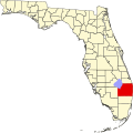
Kenwood Estates, Florida

Last updated
Kenwood Estates, Florida
USA Florida location map.svg
Red pog.svg
Kenwood Estates, Florida
Coordinates: 26°37′40″N80°06′53″W / 26.62778°N 80.11472°W / 26.62778; -80.11472 Coordinates: 26°37′40″N80°06′53″W / 26.62778°N 80.11472°W / 26.62778; -80.11472
Country United States
State Florida
County Palm Beach
Area
[1]
  Total0.17 sq mi (0.45 km2)
  Land0.17 sq mi (0.45 km2)
  Water0.00 sq mi (0.00 km2)
Elevation
16 ft (5 m)
Population
 (2020)
  Total1,435
  Density8,200.00/sq mi (3,173.61/km2)
Time zone UTC-5 (Eastern (EST))
  Summer (DST) UTC-4 (EDT)
Area code(s) 561
GNIS feature ID2628522 [2]

Kenwood Estates is a census-designated place (CDP) in Palm Beach County, Florida, United States. Its population was 1,435 as of the 2020 census. Kenwood Estates is located between Greenacres and Palm Springs; State Road 809 (Military Trail) passes through the community. More specifically, the CDP is defined from Attleboro Avenue westward to Haverhill Road, while the community's southern boundary is the L-11 Canal and the northern extent is generally along the southside of 10th Avenue North. [3]

As early as 1925, the Alfred H. Wagg Organization, inc. began advertising the Kenwood development along "the beautiful Pine Ridge of Military Trail" and noting that the area would eventually include a shopping center, apartment complexes, duplexes, and a number of single family homes. [4]

Kenwood Estates has been a priority focus area of the Countywide Community Revitalization Team (CCRT) since the early 2000s. CCRT, established by Board of County Commissioners in 1997, studies and coordinates efforts to improve certain communities in Palm Beach County. Between August 2003 and January 2010, the board approved more than $2.7 million in expenditures to improve Kenwood Estates. Projects undertaken included the addition of a neighborhood park, sidewalks, speed bumps, and streetlights, as well as improvements to drainage and pavement. A community policing deputy was also assigned to the community to restore a sense of security. [3]

Demographics

Historical population
CensusPop.
2020 1,435
U.S. Decennial Census [5]

Related Research Articles

Martin County, Florida County in Florida, United States

Martin County is a county located in the Treasure Coast region of the state of Florida, in the United States. As of the 2020 census, the population was 158,431. Its county seat is Stuart. Martin County is in the Port St. Lucie, FL Metropolitan Statistical Area.

Palm Beach County, Florida County in Florida, United States

Palm Beach County is a county located in the southeastern part of the State of Florida and lies directly north of Broward County and Miami-Dade County. According to a 2019 census report, the county had a population of 1,496,770, making it the third-most populous county in the state of Florida and the 25th-most populous county in the United States. The largest city and county seat is West Palm Beach. Named after one of its oldest settlements, Palm Beach, the county was established in 1909, after being split from Dade County. The county's modern-day boundaries were established in 1963.

Brandon, Florida Census-designated place in Florida, United States

Brandon is an unincorporated community and census-designated place (CDP) in Hillsborough County, Florida, United States. It is part of the Tampa–St. Petersburg–Clearwater Metropolitan Statistical Area. The population was 114,626 at the 2020 census, up from 103,483 at the 2010 census.

Gifford, Florida Census-designated place in Florida, United States

Gifford is an unincorporated community and census-designated place (CDP) in Indian River County, Florida, United States. It is part of the Sebastian–Vero Beach Metropolitan Statistical Area. The population was 5,511 at the 2020 census. Gifford has a rich African American history.

Hobe Sound, Florida CDP in Florida, United States

Hobe Sound is an unincorporated area and census-designated place (CDP) in Martin County, Florida, United States, located along Florida's Treasure Coast. The population was 13,163 at the 2020 census.

Kendall, Florida Census-designated place in Florida, United States

Kendall is a census-designated place in Miami-Dade County, Florida, United States. At the 2020 census, the area had a population of 80,241.

Pine Hills, Florida Census-designated place in Florida, United States

Pine Hills is a census-designated place (CDP) and unincorporated subdivision in Orange County, Florida, United States, west of Orlando. Per the 2020 U.S. Census, the population was 66,111. It is a part of the Orlando–Kissimmee–Sanford, Florida Metropolitan Statistical Area.

Canal Point, Florida CDP in Florida, United States

Canal Point is a census-designated place (CDP) in Palm Beach County, Florida, United States. Canal Point is located along the eastern shore of Lake Okeechobee, to the northeast of Pahokee and to the northwest of Bryant. The unincorporated community was originally inhabited by the Calusa tribe until almost 400 years ago. Whites began occupying the area in the 1900s decade, establishing an agrarian community. The completion of the West Palm Beach Canal in 1917 allowed crops to be shipped by boat to West Palm Beach and then to other areas of the country, while construction of Conners Highway in 1924 resulted in crops being transported by motor vehicle.

Gun Club Estates is a census-designated place (CDP) in Palm Beach County, Florida, United States. The population was 816 at the 2020 census. The CDP is located in an unincorporated area near the southwest corner of the Palm Beach International Airport (PBI) and is bounded by West Palm Beach Canal on the north, Kirk Road on the east, Gun Club Road on the south, and Military Trail on the west.

Palm Beach, Florida Town in Florida, United States

Palm Beach is an incorporated town in Palm Beach County, Florida, United States. Located on a barrier island in east-central Palm Beach County, the town is separated from several nearby cities including West Palm Beach and Lake Worth Beach by the Intracoastal Waterway to its west, though Palm Beach borders a small section of the latter and South Palm Beach at its southern boundaries. As of 2010 census, Palm Beach had a year-round population of 8,348 and an estimated population of 8,816 in 2019, increasing by around 25,000 people between November and April.

Palm Springs, Florida Village in Florida, United States

Palm Springs is a village in Palm Beach County, Florida, United States, situated approximately 61 mi (98 km) north of Miami. The village's name was likely derived from the resort city of Palm Springs, California. Located in the east-central part of the county, Palm Springs is situated north of Atlantis, east of Greenacres, west of Lake Clarke Shores and Lake Worth Beach, and southwest of West Palm Beach. The 2010 United States census recorded the village's population at 18,928, which increased to 26,890 in the 2020 census. Palm Springs is also located within the Miami metropolitan area, which had a population of approximately 6,138,333 people as of 2020.

Sandalfoot Cove, Florida Unincorporated place in Florida, United States

Sandalfoot Cove was a census-designated place (CDP) located in an unincorporated area near Boca Raton in Palm Beach County, Florida, United States. The population was 16,582 at the 2000 census. While it is not officially in the City of Boca Raton, the community is frequently classified under its umbrella term.

West Palm Beach, Florida City in Florida

West Palm Beach is a city in and the county seat of Palm Beach County, Florida, United States. It is located immediately to the west of the adjacent Palm Beach, which is situated on a barrier island across the Lake Worth Lagoon. The population was 117,415 at the 2020 census. West Palm Beach is a principal city of the Miami metropolitan area, which was home to 6,138,333 people in 2020. It is the oldest incorporated municipality in the South Florida area, incorporated as a city two years before Miami in November 1894. West Palm Beach is located approximately 68 miles (109 km) north of Downtown Miami.

Palm Harbor, Florida Census-designated place in Florida, United States

Palm Harbor is a census-designated place and unincorporated community in Pinellas County, Florida, United States. As of the 2016 American Community Survey, the CDP had a population of 60,236.

Highland City, Florida Census-designated place in Florida, United States

Highland City is a census-designated place (CDP) in Polk County, Florida, United States. The population was 2,051 at the 2000 census. It is part of the Lakeland–Winter Haven Metropolitan Statistical Area.

Druid Hills, Georgia CDP and neighborhood of Atlanta in DeKalb, Georgia, United States

Druid Hills is a community which includes both a census-designated place (CDP) in unincorporated DeKalb County, Georgia, United States, as well as a neighborhood of the city of Atlanta. The CDP's population was 14,568 at the 2010 census. The CDP formerly contained the main campus of Emory University and the Centers for Disease Control and Prevention (CDC); they were annexed by Atlanta in 2018. The Atlanta-city section of Druid Hills is one of Atlanta's most affluent neighborhoods with a mean household income in excess of $238,500.

Essex, Maryland Census-designated place in Maryland, United States

Essex is an unincorporated community and census-designated place in Baltimore County, Maryland, United States. The population was 39,262 at the 2010 census.

Lake Worth Corridor was an unincorporated census-designated place in Palm Beach County, Florida, United States, approximately 3 miles (4.8 km) west of the city of Lake Worth Beach. The population was 18,663 at the 2000 census. The CDP was not included in the 2010 census.

Suitland, Maryland Census-designated place in Maryland, United States

Suitland is an unincorporated community and census designated place (CDP) in Prince George's County, Maryland, United States, approximately one mile (1.6 km) southeast of Washington, D.C. As of the 2020 census, its population was 25,839. Prior to 2010, it was part of the Suitland-Silver Hill census-designated place.

Kenwood, California Census-designated place & unincorporated community in California, United States

Kenwood, California is an unincorporated community and census-designated place (CDP) in Sonoma County, California, located on Sonoma Highway between the cities of Santa Rosa and Sonoma. It lies east of Sonoma Creek in the upper part of Sonoma Valley, a region sometimes called the Valley of the Moon. Bennett Mountain lies west of the town, and Sugarloaf Ridge to the northeast. The population was 1,028 at the 2010 census.

References

  1. "2020 U.S. Gazetteer Files". United States Census Bureau. Retrieved October 31, 2021.
  2. "Kenwood Estates Census Designated Place". Geographic Names Information System . United States Geological Survey.
  3. 1 2 "Appendix D: Focus Areas Status Report". CCRT Area Reassessment Study (PDF) (Report). Office of Community Revitalization, Palm Beach County government. January 12, 2010. p. D-1. Retrieved October 30, 2021.
  4. "Announcing Kenwood On the Military Trail". The Palm Beach Post. December 5, 1925. p. 2. Retrieved October 30, 2021 via Newspapers.com. Lock-green.svg
  5. "Census of Population and Housing". Census.gov. Retrieved June 4, 2016.