Hypoluxo, Florida

Last updated

Hypoluxo, Florida
Town of Hypoluxo
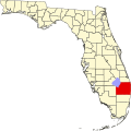
Map of Florida highlighting Hypoluxo.svg
Location of Hypoluxo, Florida
Coordinates: 26°33′46″N80°3′8″W / 26.56278°N 80.05222°W / 26.56278; -80.05222
Country Flag of the United States.svg  United States
State Flag of Florida.svg  Florida
County Flag of Palm Beach County, Florida.png Palm Beach
Incorporated 1955 [1]
Government
  Type Mayor-Council
   Mayor Michael C. Brown
   Vice Mayor Richard J. Roney
   Council Members Linda Allen,
Bradley R. Doyle,
Robert "Bob" Leupp, and
Christine Nagy
   Town Manager Mayor Michael C. Brown
   Deputy Clerk Dixie Gualtieri
Area
[2]
  Total0.81 sq mi (2.09 km2)
  Land0.57 sq mi (1.47 km2)
  Water0.24 sq mi (0.62 km2)
Elevation
7 ft (2 m)
Population
 (2020)
  Total2,687
  Density4,738.98/sq mi (1,828.83/km2)
Time zone UTC-5 (Eastern (EST))
  Summer (DST) UTC-4 (EDT)
ZIP code
33462
Area code(s) 561, 728
FIPS code 12-33150 [3]
GNIS feature ID0284449 [4]
Website www.hypoluxo.org
Hypoluxo, Florida

Hypoluxo is a town in Palm Beach County, Florida, United States. The town was incorporated in 1955 [1] and is part of the Miami metropolitan area of South Florida. It is home to the Hypoluxo Scrub Natural Area, which is a protected landscape. The population was 2,687 at the 2020 US Census.

Contents

Etymology

The origin of the name "Hypoluxo" is disputed. One theory analyzed the name as composed of the Greek root "hypo-" (under, below average) and the Latin "lux" (light). [5] Hannibel Pierce settled on Hypoluxo Island with his family in 1873. His son, Charlie W. Pierce reported that a Seminole woman told his mother that the Seminole name for Lake Worth was Hypoluxo, which he thought meant 'island', or as he put it using his marginal command of the English language: "water all around, no get out". [6] The name that the Pierces wrote as "Hypoluxo" was given as "Opoloccha" in a history posted by the Town of Hypluxo. [7] J. Clarence Simpson, citing William A. Read, states that the name is from the Creek-Seminole Hapo, meaning "mound" and Plotski, meaning "round", thus "round mound". [8] The name "Hypoluxo" appears on an 1841 War Department map. [9]

History

The area that is now the Town of Hypoluxo was first settled in 1884 by Andrew Walton Garnett, James Edward Hamilton and James William Porter. [10] Gannett and Hamilton carried the mail between the Lake Worth area and Miami as barefoot mailmen. In 1955, it was officially incorporated as a town. [1]

Geography

Hypoluxo is located at 26°33′46″N80°3′8″W / 26.56278°N 80.05222°W / 26.56278; -80.05222 (26.562897, –80.052339). [11] The town is on the mainland shore of Lake Worth and does not include any of Hypoluxo Island. [10]

According to the United States Census Bureau, the town has a total area of 0.8 square miles (2.1 km2), of which 0.6 square miles (1.6 km2) is land and 0.2 square miles (0.52 km2) (28.05%) is water.

Demographics

Historical population
CensusPop.Note
1960 114
1970 336194.7%
1980 57370.5%
1990 83044.9%
2000 2,015142.8%
2010 2,58828.4%
2020 2,6873.8%
U.S. Decennial Census [12]

2020 census

Hypoluxo racial composition
(Hispanics excluded from racial categories)
(NH = Non-Hispanic) [13]
RaceNumberPercentage
White (NH)1,98773.95%
Black or African American (NH)1706.33%
Native American or Alaska Native (NH)40.15%
Asian (NH)381.41%
Pacific Islander or Native Hawaiian (NH)10.04%
Some other race (NH)271.00%
Two or more races/Multiracial (NH)1154.28%
Hispanic or Latino (any race)34512.84%
Total2,687100.00%

As of the 2020 United States census, there were 2,687 people, 1,238 households, and 717 families residing in the town. [14]

2010 census

Hypoluxo Demographics
2010 Census HypoluxoPalm Beach CountyFlorida
Total population2,5881,320,13418,801,310
Population, percent change, 2000 to 2010+28.4%+16.7%+17.6%
Population density4,174.2/sq mi670.2/sq mi350.6/sq mi
White or Caucasian (including White Hispanic)87.9%73.5%75.0%
(Non-Hispanic White or Caucasian)83.1%60.1%57.9%
Black or African-American 6.7%17.3%16.0%
Hispanic or Latino (of any race) 6.8%19.0%22.5%
Asian 1.7%2.4%2.4%
Native American or Native Alaskan 0.0%0.5%0.4%
Pacific Islander or Native Hawaiian 0.0%0.1%0.1%
Two or more races (Multiracial) 0.6%2.3%2.5%
Some Other Race 1.5%3.9%3.6%

As of the 2010 United States census, there were 2,588 people, 1,189 households, and 641 families residing in the town. [15]

2000 census

As of the census [3] of 2000, there were 2,015 people, 1,112 households, and 549 families residing in the town. The population density was 3,389.2 inhabitants per square mile (1,308.6/km2). There were 1,606 housing units at an average density of 2,701.3 per square mile (1,043.0/km2). The racial makeup of the town was 90.62% White (87.8% were Non-Hispanic White), [16] 4.22% African American, 0.10% Native American, 1.74% Asian, 0.99% from other races, and 2.33% from two or more races. Hispanic or Latino of any race were 4.57% of the population.

In 2000, there were 1,112 households, out of which 9.8% had children under the age of 18 living with them, 41.7% were married couples living together, 5.7% had a female householder with no husband present, and 50.6% were non-families. 39.0% of all households were made up of individuals, and 11.5% had someone living alone who was 65 years of age or older. The average household size was 1.81 and the average family size was 2.33.

In 2000, in the town, the population was spread out, with 8.8% under the age of 18, 4.8% from 18 to 24, 30.3% from 25 to 44, 30.6% from 45 to 64, and 25.6% who were 65 years of age or older. The median age was 49 years. For every 100 females, there were 96.0 males. For every 100 females age 18 and over, there were 92.0 males.

In 2000, the median income for a household in the town was $50,284, and the median income for a family was $64,375. Males had a median income of $50,431 versus $32,647 for females. The per capita income for the town was $43,960. About 8.6% of families and 7.1% of the population were below the poverty line, including 10.5% of those under age 18 and 5.5% of those age 65 or over.

As of 2000, English as a first language accounted for 86.65% of all residents, while the mother tongues of French comprised 5.38%, Finnish consisted of 4.52%, Spanish was at 2.42%, and Italian made up 1.02% of the population. [17]

As of 2000, Hypoluxo had the twelfth highest percentage of Canadian residents in the US (tied with four other US areas,) which accounted 5.40% of all residents, [18] while it can be assumed that because of the percentage of Finnish speakers, Finns were around 4.52% of town's population. [19]

Controversies

The city government of Hypoluxo claims that certain streets, particularly in Hypoluxo Park, have a "public designation" but are not maintained by the city. As a result, some areas are maintained neither by the city nor any neighborhood association. For example, a seawall on the Intracoastal Waterway in Hypoluxo Park failed in 2019, leading to a dispute over whether the city would pay for repairs. [20]

Related Research Articles

<span class="mw-page-title-main">Hillsboro Beach, Florida</span> Town in the state of Florida, United States

Hillsboro Beach, officially the Town of Hillsboro Beach, is a town in Broward County, Florida, United States. The town is part of the Miami metropolitan area. Its population was 1,987 at the 2020 census.

<span class="mw-page-title-main">Pembroke Park, Florida</span> Town in the state of Florida, United States

Pembroke Park is a town in Broward County, Florida, United States. The town took its name from its location along Pembroke Road. It is part of the South Florida metropolitan area. Almost one-half of its residents live in mobile homes. As of the 2020 census, the population was 6,260.

<span class="mw-page-title-main">Golden Glades, Florida</span> Census-designated place in Florida

Golden Glades is a census-designated place (CDP) in Miami-Dade County, Florida, United States. It is part of the Miami metropolitan area of South Florida. The population was 32,499 at the 2020 US census.

<span class="mw-page-title-main">Goulds, Florida</span> Census-designated place in Florida

Goulds is an unincorporated community and census-designated place (CDP) in Miami-Dade County, Florida, United States. The area was originally populated as the result of a stop on the Florida East Coast Railroad. The railroad depot was located near the current Southwest 224th Street. The community was named after its operator, Lyman Gould, who cut trees for railroad ties. It is part of the Miami metropolitan area of South Florida. As of the 2020 US census, the population stood at 11,446, up from 10,103 in 2010 US census.

<span class="mw-page-title-main">Palm Springs North, Florida</span> Census-designated place in Florida

Palm Springs North is an unincorporated community and census-designated place (CDP) in Miami-Dade County, Florida, United States. It is part of the Miami metropolitan area of South Florida. The population was 5,030 at the 2020 census.

<span class="mw-page-title-main">Richmond West, Florida</span> Census-designated place in Florida

Richmond West is a census-designated place (CDP) in Miami-Dade County, Florida, United States. It is part of the Miami metropolitan area of South Florida. The population was 35,884 at the 2020 census, up from 31,973 at the 2010 census.

<span class="mw-page-title-main">Westwood Lakes, Florida</span> Census-designated place in Florida

Westwood Lakes is a census-designated place and unincorporated community of Miami-Dade County, Florida, United States. It is part of the Miami metropolitan area of South Florida. The population was 11,373 at the 2020 census.

<span class="mw-page-title-main">Atlantis, Florida</span> City in Florida, United States

Atlantis is a city in Palm Beach County, Florida, United States. It is part of the Miami metropolitan area of South Florida. As of the 2020 census, the city had a population of 2,142.

<span class="mw-page-title-main">Golf, Florida</span> Village in Florida, United States

The Village of Golf is a village in Palm Beach County, Florida, United States. It's also part of the Miami metropolitan area of South Florida. As of 2020, the population recorded by the U.S. Census Bureau was 255.

<span class="mw-page-title-main">Greenacres, Florida</span> City in Florida, United States

Greenacres is a city in Palm Beach County, Florida, United States. It is part of South Florida's Miami metropolitan area. As of the 2020 census, the city had a population of 43,990 residents.

<span class="mw-page-title-main">Haverhill, Florida</span> Town in the state of Florida, United States

Haverhill is a town in Palm Beach County, Florida, United States. It is a part of the Miami metropolitan area of South Florida. Haverhill became a town on May 3, 1950, and was named after the city of Haverhill, Massachusetts. The town is located in east-central Palm Beach County near the western periphery of the Palm Beach International Airport, and is also small geographically, encompassing just 0.63 square miles (1.6 km2). The population of the town was 2,187 as of the 2020 US Census.

<span class="mw-page-title-main">Highland Beach, Florida</span> Town in the state of Florida, United States

Highland Beach is a town in Palm Beach County, Florida, United States. It is part of the Miami metropolitan area of South Florida, and situated 50 miles north of Miami and 28 miles south of Palm Beach. As of the 2020 US census, the population was 4,295.

<span class="mw-page-title-main">Juno Beach, Florida</span> Town in the state of Florida, United States

Juno Beach is a town in Palm Beach County, Florida, United States. Juno Beach is home to the headquarters of Florida Power & Light, the Loggerhead Marinelife Center and the Seminole Golf Club. It was also the original county seat for the area that was then known as Dade County. Juno Beach is in the Miami metropolitan area of South Florida. The political climate in Juno Beach is leaning liberal. The property crime rate is around the US national average, with the violent crime rate well below average. The Town of Juno Beach was officially incorporated in 1953. As of 2020, the town's population recorded by the U.S. Census Bureau was 3,858.

<span class="mw-page-title-main">Lake Park, Florida</span> Town in the state of Florida, United States

Lake Park is a town in Palm Beach County, Florida, United States. Lake Park is part of the Miami Metropolitan Area of South Florida. The population was 9,047 at the 2020 US census.

<span class="mw-page-title-main">Lantana, Florida</span> Town in the state of Florida, United States

Lantana is a town in Palm Beach County, Florida, United States. It is 37 miles (60 km) north from Fort Lauderdale and 62 miles (100 km) north of Miami. This town is part of the Miami metropolitan area of South Florida. The population was 11,504 at the 2020 United States Census.

<span class="mw-page-title-main">Mangonia Park, Florida</span> Town in the state of Florida, United States

Mangonia Park is a town in Palm Beach County, Florida, United States. It is a part of the Miami metropolitan area of South Florida as well as Uptown West Palm, which includes the cities of Riviera Beach and West Palm Beach. As of 2020, the population recorded by the U.S. Census Bureau was 2,142.

<span class="mw-page-title-main">Ocean Ridge, Florida</span> Town in the state of Florida, United States

Ocean Ridge is a town in Palm Beach County, Florida, United States. The town is part of the Miami metropolitan area of South Florida. The population was 1,830 at the 2020 US census.

<span class="mw-page-title-main">Palm Beach Shores, Florida</span> Town in the state of Florida, United States

Palm Beach Shores is a town in Palm Beach County, Florida, United States. The town is part of the Miami metropolitan area of South Florida. The population was 1,330 at the 2020 US census.

<span class="mw-page-title-main">Royal Palm Beach, Florida</span> Village in Florida

Royal Palm Beach is a village in southeast Florida, located within Palm Beach County. Despite its name, the village is located approximately fifteen miles inland from the Atlantic Ocean. It is part of the Miami metropolitan area of South Florida. The population was at 38,932 residents in the 2020 US census.

<span class="mw-page-title-main">South Bay, Florida</span> City in Florida, United States

South Bay is a city in Palm Beach County, Florida, United States. It is the westernmost municipality in the South Florida metropolitan area. As of 2020, the population recorded by the U.S. Census Bureau was 4,860 residents. While the current estimates place South Bay's population in the incorporated city limits at more than 4,000 people, surrounding areas increase the population figures to 54,000 people in a 25-mile (40 km) radius and more than 1.4 million in a 50-mile (80 km) radius.

References

  1. 1 2 3 "Palm Beach County History Online: Timeline of Municipalities". www.pbchistoryonline.org via the Wayback Machine . Retrieved July 12, 2023.
  2. "2020 U.S. Gazetteer Files". United States Census Bureau. Retrieved October 31, 2021.
  3. 1 2 "U.S. Census website". United States Census Bureau . Retrieved January 31, 2008.
  4. "US Board on Geographic Names". United States Geological Survey. October 25, 2007. Retrieved January 31, 2008.
  5. Eliot Kleinberg (September 16, 1987). "What's in a name? Lots of history if it's a town". The Palm Beach Post. p. 7D. Retrieved March 9, 2021 via Newspapers.com. Lock-green.svg
  6. Pierce, Charles W. (1970). Pioneer Life in Southeast Florida. Coral Gables, Florida: University of Miami Press. p. 54. ISBN   0-87024-163-X.
  7. "Early Settlers". Town of Hypoluxo. Archived from the original on November 12, 2011.
  8. Simpson, J. Clarence (1956). Florida Place-Names of Indian Derivation. Tallahassee, Florida: State of Florida State Board of Conservation. p. 61.
  9. "Town of Hypoluxo". Archived from the original on December 29, 2003. Retrieved January 19, 2004.
  10. 1 2 "Hypoluxo". Palm Beach County History Online. 2009. Archived from the original on April 5, 2023. Retrieved October 17, 2023.
  11. "US Gazetteer files: 2010, 2000, and 1990". United States Census Bureau. February 12, 2011. Retrieved April 23, 2011.
  12. "Census of Population and Housing". Census.gov. Retrieved June 4, 2015.
  13. "Explore Census Data". data.census.gov. Retrieved February 11, 2022.
  14. "S1101 HOUSEHOLDS AND FAMILIES - 2020: Hypoluxo town, Florida". United States Census Bureau .
  15. "S1101 HOUSEHOLDS AND FAMILIES - 2010: Hypoluxo town, Florida". United States Census Bureau .
  16. "Demographics of Hypoluxo, FL". MuniNetGuide.com. Retrieved November 23, 2007.
  17. "MLA Data Center Results for Hypoluxo, Florida". Modern Language Association . Retrieved November 23, 2007.
  18. "Ancestry Map of Canadian Communities". Epodunk.com. Retrieved November 23, 2007.
  19. "Ancestry Map of Finnish Communities". Epodunk.com. Retrieved November 23, 2007.
  20. "No one claiming mangled Hypoluxo sea wall embankment".