Watergate, Florida

Last updated

Watergate, Florida
USA Florida location map.svg
Red pog.svg
Watergate, Florida
Coordinates: 26°20′09″N80°12′45″W / 26.33583°N 80.21250°W / 26.33583; -80.21250
Country Flag of the United States.svg  United States
State Flag of Florida.svg  Florida
County Flag of Palm Beach County, Florida.png Palm Beach
Area
[1]
  Total0.42 sq mi (1.08 km2)
  Land0.42 sq mi (1.08 km2)
  Water0.00 sq mi (0.00 km2)
Elevation
13 ft (4 m)
Population
 (2020)
  Total3,459
  Density8,314.90/sq mi (3,211.03/km2)
Time zone UTC-5 (Eastern (EST))
  Summer (DST) UTC-4 (EDT)
ZIP code
33428 [2]
Area code 561
GNIS feature ID2628537 [3]

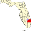
Watergate is a census-designated place in Palm Beach County, Florida, United States. It is part of the Miami metropolitan area of South Florida. The population was 3,459 as of the 2020 census.

Contents

Geography

Watergate is located at 26°20′09″N80°12′45″W / 26.33583°N 80.21250°W / 26.33583; -80.21250 , which is on the west side of U.S. Route 441, west of Boca Raton.

Demographics

Historical population
CensusPop.Note
2010 2,942
2020 3,45917.6%
U.S. Decennial Census [4]

2020 census

Watergate racial composition
(Hispanics excluded from racial categories)
(NH = Non-Hispanic) [5]
RaceNumberPercentage
White (NH)1,67948.54%
Black or African American (NH)1825.26%
Native American or Alaska Native (NH)80.23%
Asian (NH)1032.98%
Pacific Islander or Native Hawaiian (NH)00.00%
Some Other Race (NH)1614.65%
Mixed/Multiracial (NH)3108.96%
Hispanic or Latino 1,01629.37%
Total3,459

As of the 2020 United States census, there were 3,459 people, 1,137 households, and 716 families residing in the CDP. [6]

2010 census

Watergate racial composition
(Hispanics excluded from racial categories)
(NH = Non-Hispanic) [7]
RaceNumberPercentage
White (NH)2,06470.16%
Black or African American (NH)1414.79%
Native American or Alaska Native (NH)200.68%
Asian (NH)461.56%
Pacific Islander or Native Hawaiian (NH)00.00%
Some Other Race (NH)311.05%
Mixed/Multiracial (NH)481.63%
Hispanic or Latino 59220.12%
Total2,942

As of the 2010 United States census, there were 2,942 people, 967 households, and 584 families residing in the CDP. [8]

Related Research Articles

Boulevard Gardens is a census-designated place (CDP) in Broward County, Florida, United States. The population was 1,457 at the 2020 census.

Franklin Park is a census-designated place (CDP) in Broward County, Florida, United States. The population was 1,025 at the 2020 census.

Hillsboro Pines is a census-designated place (CDP) in Broward County, Florida, United States. The population was 496 at the 2020 census.

<span class="mw-page-title-main">Three Lakes, Florida</span> Census-designated place in Florida, United States

Three Lakes is a census-designated place (CDP) in Miami-Dade County, Florida, United States. The population was 16,540 at the 2020 census, up from 15,047 in 2010. Its name comes from the planned community of Three Lakes, which is located inside Three Lakes CDP boundaries.

Gun Club Estates is a census-designated place (CDP) in Palm Beach County, Florida, United States. It is part of the Miami metropolitan area of South Florida. The population was 816 at the 2020 US census.

Juno Ridge is a census-designated place (CDP) in Palm Beach County, Florida, United States. It is part of the Miami metropolitan area of South Florida. The population was 1,186 at the 2020 US census.

Lake Belvedere Estates is a census-designated place (CDP) in Palm Beach County, Florida, United States. It is part of the Miami metropolitan area of South Florida. The population was 2,091 at the 2020 US census.

Limestone Creek is a census-designated place (CDP) in Palm Beach County, Florida, United States. It is part of the Miami metropolitan area of South Florida. The population was 1,316 at the 2020 US census.

Plantation Mobile Home Park is a census-designated place (CDP) in Palm Beach County, Florida, United States. It is part of the Miami metropolitan area of South Florida. The population was 1,462 at the 2020 US census.

Royal Palm Estates is a census-designated place (CDP) in Palm Beach County, Florida, United States. It is part of the Miami metropolitan area of South Florida. The population was 1,974 at the 2020 census.

Schall Circle is a census-designated place (CDP) in Palm Beach County, Florida, United States. It is part of the Miami metropolitan area of South Florida. The population was 792 at the 2020 US census.

Seminole Manor is a census-designated place (CDP) in Palm Beach County, Florida, United States. The CDP was developed in the late 1950s, with the majority of houses built in 1958 and 1959. It is part of the Miami metropolitan area of South Florida. The population was 2,562 at the 2020 US census.

Stacy Street is a residential street and surrounding census-designated place (CDP) in Palm Beach County, Florida, United States. In the 2010 and 2020 US Census, the CDP is misspelled as Stacey Street. It is part of the Miami metropolitan area of South Florida. The population was 978 at the 2020 US census.

<span class="mw-page-title-main">Westgate, Florida</span> Census-designated place in Florida, United States

Westgate is an unincorporated census-designated place (CDP) in Palm Beach County, Florida, United States. Prior to the 2010 US census, the CDP was listed as Westgate-Belvedere Homes. It is part of the Miami metropolitan area of South Florida. The population was 8,435 at the 2020 census.

<span class="mw-page-title-main">Seth Ward, Texas</span> Census-designated place in Texas, United States

Seth Ward is an unincorporated community and census-designated place (CDP) in Hale County, Texas, United States. The population was 2,025 at the 2010 census.

Jupiter Farms is a census-designated place (CDP) and an agriculture residential community in Palm Beach County, Florida, United States. Locally known as "The Farms", it is located west of Florida's Turnpike on Indiantown Road, the major highway through the community. "The Farms" is composed of roughly 15 square miles (39 km2) of land, and is part of the Miami metropolitan area of South Florida. As of the 2020 US census, the CDP's population had 12,572 residents.

San Castle is a census-designated place in Palm Beach County, Florida, United States. It is part of the Miami metropolitan area of South Florida. The population was 3,755 as of the 2020 census.

Cabana Colony is a census-designated place (CDP) in Palm Beach County, Florida, United States. The CDP is part of the Miami metropolitan area of South Florida. Its population was 2,460 as of the 2020 census.

<span class="mw-page-title-main">Acacia Villas, Florida</span> CDP in Florida, United States

Acacia Villas is a census-designated place in Palm Beach County, Florida, United States. It is part of the Miami metropolitan area of South Florida. The population was 398 as of the 2020 census.

Pine Air is a census-designated place in Palm Beach County, Florida, United States. It is a part of the Miami metropolitan area of South Florida. The population was 2,190 as of the 2020 census.

References

  1. "2020 U.S. Gazetteer Files". United States Census Bureau. Retrieved December 2, 2021.
  2. "Watergate, FL ZIP Code". zipdatamaps.com. 2023. Retrieved February 17, 2023.
  3. "Watergate Census Designated Place". Geographic Names Information System . United States Geological Survey, United States Department of the Interior.
  4. "Census of Population and Housing". Census.gov. Retrieved June 4, 2016.
  5. "HISPANIC OR LATINO, AND NOT HISPANIC OR LATINO BY RACE: 2020". data.census.gov. Retrieved August 1, 2023.
  6. "HOUSEHOLDS AND FAMILIES: 2020". data.census.gov. Retrieved August 1, 2023.
  7. "HISPANIC OR LATINO, AND NOT HISPANIC OR LATINO BY RACE: 2010". data.census.gov. Retrieved August 1, 2023.
  8. "HOUSEHOLDS AND FAMILIES: 2010". data.census.gov. Retrieved August 1, 2023.