Acacia Villas, Florida

Last updated

Acacia Villas, Florida
CDP
Palm Beach County Florida Incorporated and Unincorporated areas Acacia Villas Highlighted 1200075.svg
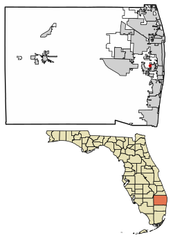
Location of Acacia Villas in Palm Beach County, Florida.
Coordinates: 26°38′45″N80°06′38″W / 26.64583°N 80.11056°W / 26.64583; -80.11056
Country Flag of the United States.svg  United States
State Flag of Florida.svg  Florida
County Flag of Palm Beach County, Florida.png Palm Beach
Area
[1]
  Total0.07 sq mi (0.18 km2)
  Land0.07 sq mi (0.18 km2)
  Water0.00 sq mi (0.00 km2)
Elevation
16 ft (5 m)
Population
 (2020)
  Total398
  Density5,685.71/sq mi (2,185.29/km2)
Time zone UTC-5 (Eastern (EST))
  Summer (DST) UTC-4 (EDT)
ZIP code
33406 [2]
Area code(s) 561, 728
GNIS feature ID2628517 [3]

Acacia Villas is a census-designated place (CDP) in Palm Beach County, Florida, United States. It is part of the Miami metropolitan area of South Florida. The population was 398 as of the 2020 census.

Contents

Geography

Acacia Villas is located on the east side of Military Trail; it borders Palm Springs on its north, east, and south sides.

Demographics

Historical population
CensusPop.Note
2010 427
2020 398−6.8%
U.S. Decennial Census [4]

2020 census

Acacia Villas racial composition
(Hispanics excluded from racial categories)
(NH = Non-Hispanic) [5]
RaceNumberPercentage
White (NH)8521.36%
Black or African American (NH)92.26%
Native American or Alaska Native (NH)00.00%
Asian (NH)82.01%
Pacific Islander or Native Hawaiian (NH)00.00%
Some Other Race (NH)20.50%
Mixed/Multiracial (NH)143.52%
Hispanic or Latino (any race)28070.35%
Total398100.00%

As of the 2020 United States census, there were 398 people, 149 households, and 107 families residing in the CDP. [6]

2010 census

Acacia Villas racial composition
(Hispanics excluded from racial categories)
(NH = Non-Hispanic) [7]
RaceNumberPercentage
White (NH)9923.18%
Black or African American (NH)378.67%
Native American or Alaska Native (NH)00.00%
Asian (NH)163.75%
Pacific Islander or Native Hawaiian (NH)00.00%
Some Other Race (NH)10.23%
Mixed/Multiracial (NH)40.94%
Hispanic or Latino (any race)27063.23%
Total427100.00%

As of the 2010 United States census, there were 427 people, 110 households, and 110 families residing in the CDP. [8]

Related Research Articles

<span class="mw-page-title-main">Country Club, Florida</span> Census-designated place in Florida

Country Club is a census-designated place and a suburban unincorporated community located in northwest Miami-Dade County, Florida, United States. It is located in the Miami metropolitan area of South Florida. The CDP is named after the Country Club of Miami, which was established in 1961 in what was then an unpopulated and undeveloped section of the county. The population was 49,967 at the 2020 census, up from 3,408 in 1990.

<span class="mw-page-title-main">Palm Springs North, Florida</span> Census-designated place in Florida

Palm Springs North is an unincorporated community and census-designated place (CDP) in Miami-Dade County, Florida, United States. It is part of the Miami metropolitan area of South Florida. The population was 5,030 at the 2020 census.

<span class="mw-page-title-main">West Perrine, Florida</span> Census-designated place in Florida

West Perrine is a census-designated place (CDP) in Miami-Dade County, Florida, United States. It is part of the Miami metropolitan area of South Florida. The population was 10,602 at the 2020 census, up from 9,460 in 2010.

<span class="mw-page-title-main">Westwood Lakes, Florida</span> Census-designated place in Florida

Westwood Lakes is a census-designated place and unincorporated community of Miami-Dade County, Florida, United States. It is part of the Miami metropolitan area of South Florida. The population was 11,373 at the 2020 census.

Gun Club Estates is a census-designated place (CDP) in Palm Beach County, Florida, United States. It is part of the Miami metropolitan area of South Florida. The population was 816 at the 2020 US census.

Juno Ridge is a census-designated place (CDP) in Palm Beach County, Florida, United States. It is part of the Miami metropolitan area of South Florida. The population was 1,186 at the 2020 US census.

Lake Belvedere Estates is a census-designated place (CDP) in Palm Beach County, Florida, United States. It is part of the Miami metropolitan area of South Florida. The population was 2,091 at the 2020 US census.

<span class="mw-page-title-main">Lake Harbor, Florida</span> CDP in Florida, United States

Lake Harbor is a census-designated place (CDP) in Palm Beach County, Florida, United States. It is part of the Miami metropolitan area of South Florida despite being physically and culturally closer to the Florida Heartland. The population was 49 at the 2020 US census.

Limestone Creek is a census-designated place (CDP) in Palm Beach County, Florida, United States. It is part of the Miami metropolitan area of South Florida. The population was 1,316 at the 2020 US census.

Plantation Mobile Home Park is a census-designated place (CDP) in Palm Beach County, Florida, United States. It is part of the Miami metropolitan area of South Florida. The population was 1,462 at the 2020 US census.

Royal Palm Estates is a census-designated place (CDP) in Palm Beach County, Florida, United States. It is part of the Miami metropolitan area of South Florida. The population was 1,974 at the 2020 census.

Schall Circle is a census-designated place (CDP) in Palm Beach County, Florida, United States. It is part of the Miami metropolitan area of South Florida. The population was 792 at the 2020 US census.

Seminole Manor is a census-designated place (CDP) in Palm Beach County, Florida, United States. The CDP was developed in the late 1950s, with the majority of houses built in 1958 and 1959. It is part of the Miami metropolitan area of South Florida. The population was 2,562 at the 2020 US census.

Stacy Street is a residential street and surrounding census-designated place (CDP) in Palm Beach County, Florida, United States. In the 2010 and 2020 US Census, the CDP is misspelled as Stacey Street. It is part of the Miami metropolitan area of South Florida. The population was 978 at the 2020 US census.

<span class="mw-page-title-main">Westgate, Florida</span> Census-designated place in Florida, United States

Westgate is an unincorporated census-designated place (CDP) in Palm Beach County, Florida, United States. Prior to the 2010 US census, the CDP was listed as Westgate-Belvedere Homes. It is part of the Miami metropolitan area of South Florida. The population was 8,435 at the 2020 census.

Jupiter Farms is a census-designated place (CDP) and an agriculture residential community in Palm Beach County, Florida, United States. Locally known as "The Farms", it is located west of Florida's Turnpike on Indiantown Road, the major highway through the community. "The Farms" is composed of roughly 15 square miles (39 km2) of land, and is part of the Miami metropolitan area of South Florida. As of the 2020 US census, the CDP's population had 12,572 residents.

San Castle is a census-designated place in Palm Beach County, Florida, United States. It is part of the Miami metropolitan area of South Florida. The population was 3,755 as of the 2020 census.

Watergate is a census-designated place in Palm Beach County, Florida, United States. It is part of the Miami metropolitan area of South Florida. The population was 3,459 as of the 2020 census.

Cabana Colony is a census-designated place (CDP) in Palm Beach County, Florida, United States. The CDP is part of the Miami metropolitan area of South Florida. Its population was 2,460 as of the 2020 census.

Pine Air is a census-designated place (CDP) in Palm Beach County, Florida, United States. It is a part of the Miami metropolitan area of South Florida. The population was 2,190 as of the 2020 census.

References

  1. "2020 U.S. Gazetteer Files". United States Census Bureau. Retrieved October 31, 2021.
  2. "Acacia Villas, FL ZIP Code". zipdatamaps.com. 2023. Retrieved February 19, 2023.
  3. "Acacia Villas Census Designated Place". Geographic Names Information System . United States Geological Survey, United States Department of the Interior.
  4. "Census of Population and Housing". Census.gov. Retrieved June 4, 2016.
  5. "HISPANIC OR LATINO, AND NOT HISPANIC OR LATINO BY RACE: 2020". data.census.gov. Retrieved July 17, 2023.
  6. "HOUSEHOLDS AND FAMILIES:2020". data.census.gov. Retrieved July 17, 2023.
  7. "HISPANIC OR LATINO, AND NOT HISPANIC OR LATINO BY RACE: 2010". data.census.gov. Retrieved July 17, 2023.
  8. "HOUSEHOLDS AND FAMILIES: 2010". data.census.gov. Retrieved July 17, 2023.