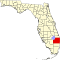
Limestone Creek, Florida

Last updated

Limestone Creek, Florida
CDP
Coordinates: 26°56′38″N80°8′25″W / 26.94389°N 80.14028°W / 26.94389; -80.14028
Country Flag of the United States.svg  United States
State Flag of Florida.svg  Florida
County Flag of Palm Beach County, Florida.png Palm Beach
Area
[1]
  Total0.39 sq mi (1.01 km2)
  Land0.39 sq mi (1.01 km2)
  Water0.00 sq mi (0.00 km2)
Elevation
10 ft (3 m)
Population
 (2020)
  Total1,316
  Density3,365.73/sq mi (1,299.27/km2)
Time zone UTC-5 (Eastern (EST))
  Summer (DST) UTC-4 (EDT)
ZIP code
33458 [2]
Area code(s) 561, 728
FIPS code 12-40562 [3]
GNIS feature ID1853267 [4]

Limestone Creek is a census-designated place (CDP) in Palm Beach County, Florida, United States. It is part of the Miami metropolitan area of South Florida. The population was 1,316 at the 2020 US census.

Contents

Geography

Limestone Creek is located at 26°56′38″N80°8′25″W / 26.94389°N 80.14028°W / 26.94389; -80.14028 (26.943809, -80.140330). [5]

It is a enclave community surrounded by Jupiter on all sides, and located near Indiantown Road and Interstate 95. [6]

According to the United States Census Bureau, the CDP has a total area of 1.01 km2 (0.39 mi2), all land.

Demographics

Historical population
CensusPop.Note
2000 569
2010 1,01478.2%
2020 1,31629.8%
U.S. Decennial Census [7]

2020 census

Limestone Creek, Florida – Racial and Ethnic Composition
(NH = Non-Hispanic)
Note: the US Census treats Hispanic/Latino as an ethnic category. This table excludes Latinos from the racial categories and assigns them to a separate category. Hispanics/Latinos may be of any race.
Race / EthnicityPop 2000 [8] Pop 2010 [9] Pop 2020 [10] % 2000% 20102020
White alone (NH)6116330810.72%16.07%23.40%
Black or African American alone (NH)43961443577.15%60.55%33.05%
Native American or Alaska Native alone (NH)17130.18%0.69%0.99%
Asian alone (NH)614641.05%1.38%4.86%
Pacific Islander alone (NH)0040.00%0.00%0.30%
Some Other Race alone (NH)02170.00%0.20%1.29%
Mixed Race or Multi-Racial (NH)827451.41%2.66%3.42%
Hispanic or Latino (any race)541874309.49%18.44%32.67%
Total5691,0141,316100.00%100.00%100.00%

As of the 2020 United States census, there were 1,316 people, 422 households, and 239 families residing in the CDP. [11]

2010 census

As of the 2010 United States census, there were 1,014 people, 273 households, and 166 families residing in the CDP. [12]

2000 census

As of the census [3] of 2000, there were 569 people, 157 households, and 124 families living in the CDP. The population density was 488.2/km2 (1,256.7/mi2). There were 166 housing units at an average density of 142.4/km2 (366.6/mi2). The racial makeup of the CDP was 17.22% White (10.7% were Non-Hispanic White), [13] 77.33% African American, 0.18% Native American, 1.05% Asian, 1.76% from other races, and 2.46% from two or more races. Hispanic or Latino of any race were 9.49% of the population.

In 2000, there were 157 households, out of which 45.2% had children under the age of 18 living with them, 42.0% were married couples living together, 31.2% had a female householder with no husband present, and 20.4% were non-families. 15.9% of all households were made up of individuals, and 3.8% had someone living alone who was 65 years of age or older. The average household size was 3.62 and the average family size was 4.02.

As of 2000, in the CDP, the population was spread out, with 38.8% under the age of 18, 7.7% from 18 to 24, 29.9% from 25 to 44, 16.3% from 45 to 64, and 7.2% who were 65 years of age or older. The median age was 28 years. For every 100 females, there were 96.2 males. For every 100 females age 18 and over, there were 81.3 males.

In 2000, the median income for a household in the CDP was $31,125, and the median income for a family was $30,875. Males had a median income of $33,239 versus $22,750 for females. The per capita income for the CDP was $12,195. About 7.0% of families and 8.5% of the population were below the poverty line, including 6.1% of those under age 18 and 34.5% of those age 65 or over.

As of 2000, 100% of the population spoke English as their first language. [14]

Related Research Articles

Boulevard Gardens is a census-designated place (CDP) in Broward County, Florida, United States. The population was 1,457 at the 2020 census.

Franklin Park is a census-designated place (CDP) in Broward County, Florida, United States. The population was 1,025 at the 2020 census.

Hillsboro Pines is a census-designated place (CDP) in Broward County, Florida, United States. The population was 496 at the 2020 census.

<span class="mw-page-title-main">Washington Park, Florida</span> CDP in Florida, United States

Washington Park is a census-designated place (CDP) in Broward County, Florida, United States. Its population was 1,948 at the 2020 census.

<span class="mw-page-title-main">Meadow Woods, Florida</span> Census-designated place in Florida, United States

Meadow Woods is a census-designated place (CDP) and an unincorporated suburban development area located in southern Orange County, Florida, United States, between Orlando International Airport and Kissimmee. It is part of the Orlando–Kissimmee–Sanford, Florida Metropolitan Statistical Area. As of 2020, the population was 43,790.

<span class="mw-page-title-main">South Apopka, Florida</span> Census-designated place in Florida, United States

South Apopka is a census-designated place and an unincorporated area in Orange County, Florida, United States. Per the 2020 census, the population was 6,803. It is part of the Orlando–Kissimmee Metropolitan Statistical Area.

<span class="mw-page-title-main">Union Park, Florida</span> Census-designated place in Florida, United States

Union Park is a census-designated place (CDP) in Orange County, Florida, United States. The population was 10,452 at the 2020 census. It is part of the Orlando–Kissimmee Metropolitan Statistical Area. The ZIP codes for Union Park are 32817 and 32825. The community is southwest of the University of Central Florida.

<span class="mw-page-title-main">Cypress Lakes, Florida</span> Unincorporated place in Florida, United States

Cypress Lakes was a former census-designated place (CDP) and current unincorporated place in Palm Beach County, Florida, United States. The population was 1,468 at the 2000 census.

Dunes Road is a former census-designated place (CDP) and current unincorporated place in Palm Beach County, Florida, United States. The population was 391 at the 2000 census.

Juno Ridge is a census-designated place (CDP) in Palm Beach County, Florida, United States. It is part of the Miami metropolitan area of South Florida. The population was 1,186 at the 2020 US census.

Lake Belvedere Estates is a census-designated place (CDP) in Palm Beach County, Florida, United States. It is part of the Miami metropolitan area of South Florida. The population was 2,091 at the 2020 US census.

Plantation Mobile Home Park is a census-designated place (CDP) in Palm Beach County, Florida, United States. It is part of the Miami metropolitan area of South Florida. The population was 1,462 at the 2020 US census.

Royal Palm Estates is a census-designated place (CDP) in Palm Beach County, Florida, United States. It is part of the Miami metropolitan area of South Florida. The population was 1,974 at the 2020 census.

Schall Circle is a census-designated place (CDP) in Palm Beach County, Florida, United States. It is part of the Miami metropolitan area of South Florida. The population was 792 at the 2020 US census.

Seminole Manor is a census-designated place (CDP) in Palm Beach County, Florida, United States. The CDP was developed in the late 1950s, with the majority of houses built in 1958 and 1959. It is part of the Miami metropolitan area of South Florida. The population was 2,562 at the 2020 US census.

Stacy Street is a residential street and surrounding census-designated place (CDP) in Palm Beach County, Florida, United States. In the 2010 and 2020 US Census, the CDP is misspelled as Stacey Street. It is part of the Miami metropolitan area of South Florida. The population was 978 at the 2020 US census.

<span class="mw-page-title-main">Westgate, Florida</span> CDP in Florida, United States

Westgate is an unincorporated census-designated place (CDP) in Palm Beach County, Florida, United States. Prior to the 2010 US census, the CDP was listed as Westgate-Belvedere Homes. It is part of the Miami metropolitan area of South Florida. The population was 8,435 at the 2020 census.

<span class="mw-page-title-main">Valley Falls, Rhode Island</span> Village and census-designated place in Rhode Island, US

Valley Falls is a village and census-designated place (CDP) in the town of Cumberland, Providence County, Rhode Island, United States. The population was 12,094 at the 2020 census.

<span class="mw-page-title-main">La Pryor, Texas</span> CDP in Texas, United States

La Pryor is a census-designated place (CDP) in Zavala County, Texas, United States. Its population was 1,643 at the 2010 census.

<span class="mw-page-title-main">Walpole (CDP), Massachusetts</span> Census-designated place in Massachusetts, United States

Walpole is a small census-designated place (CDP) located within the much larger town of Walpole in Norfolk County, Massachusetts, United States. Walpole Town as it is called by the US Census Bureau, also includes a much larger population. The population of the Census Designated Place was 5,918 at the 2010 census.

References

  1. "2020 U.S. Gazetteer Files". United States Census Bureau. Retrieved October 31, 2021.
  2. "Limestone Creek FL ZIP Code". zipdatamaps.com. 2023. Retrieved February 17, 2023.
  3. 1 2 "U.S. Census website". United States Census Bureau . Retrieved January 31, 2008.
  4. "US Board on Geographic Names". United States Geological Survey. October 25, 2007. Retrieved January 31, 2008.
  5. "US Gazetteer files: 2010, 2000, and 1990". United States Census Bureau. February 12, 2011. Retrieved April 23, 2011.
  6. "Roadway Atlas (Page 5)" (PDF). Palm Beach County Engineering and Public Works. Retrieved December 2, 2021.
  7. "Census of Population and Housing". Census.gov. Retrieved June 4, 2016.
  8. "P004 Hispanic or Latino, and Not Hispanic or Latino by Race – 2000: DEC Summary File 1 – Limestone Creek CDP, Florida". United States Census Bureau .
  9. "P2 Hispanic or Latino, and Not Hispanic or Latino by Race – 2010: DEC Redistricting Data (PL 94-171) – Limestone Creek CDP, Florida". United States Census Bureau .
  10. "P2 Hispanic or Latino, and Not Hispanic or Latino by Race – 2020: DEC Redistricting Data (PL 94-171) – Limestone Creek CDP, Florida". United States Census Bureau .
  11. "HOUSEHOLDS AND FAMILIES: 2020". data.census.gov. Retrieved July 25, 2023.
  12. "HOUSEHOLDS AND FAMILIES: 2010". data.census.gov. Retrieved July 25, 2023.
  13. "Demographics of Limestone Creek, FL". MuniNetGuide.com. Retrieved December 13, 2007.
  14. "MLA Data Center Results for Limestone Creek, Florida". Modern Language Association . Retrieved December 13, 2007.