Lake Harbor, Florida | |
---|---|
Coordinates: 26°41′13″N80°48′27″W / 26.68694°N 80.80750°W | |
Country | United States |
State | Florida |
County | Palm Beach |
Area | |
• Total | 1.32 sq mi (3.42 km2) |
• Land | 1.32 sq mi (3.42 km2) |
• Water | 0.00 sq mi (0.00 km2) |
Elevation | 13 ft (4 m) |
Population (2020) | |
• Total | 49 |
• Density | 37.09/sq mi (14.33/km2) |
Time zone | UTC-5 (Eastern (EST)) |
• Summer (DST) | UTC-4 (EDT) |
ZIP code | 33459 |
Area code(s) | 561, 728 |
FIPS code | 12-38000 [2] |
GNIS feature ID | 0285247 [3] |
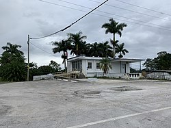
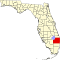
Lake Harbor is a census-designated place (CDP) in Palm Beach County, Florida, United States. It is part of the Miami metropolitan area of South Florida despite being physically and culturally closer to the Florida Heartland. The population was 49 at the 2020 US census.
Lake Harbor is located at 26°41′13″N80°48′27″W / 26.68694°N 80.80750°W (26.686985, -80.807613). [4]
According to the United States Census Bureau, the CDP has a total area of 3.4 km2 (1.3 sq mi), all land. The community is centered at the intersection of Mutt Thomas Road and U.S. Route 27 (which runs concurrently with Florida State Road 80).
It is located along the southern banks of Lake Okeechobee, at the beginning of the Miami Canal. John Stretch Park is also located alongside the north end of Lake Harbor and the Lake Okeechobee.
Census | Pop. | Note | %± |
---|---|---|---|
2000 | 195 | — | |
2010 | 45 | −76.9% | |
2020 | 49 | 8.9% | |
U.S. Decennial Census [5] |
Race | Number | Percentage |
---|---|---|
White (NH) | 22 | 44.90% |
Black or African American (NH) | 13 | 26.53% |
Native American or Alaska Native (NH) | 0 | 0.00% |
Asian (NH) | 0 | 0.00% |
Pacific Islander or Native Hawaiian (NH) | 0 | 0.00% |
Some Other Race (NH) | 0 | 0.00% |
Mixed/Multiracial (NH) | 0 | 0.00% |
Hispanic or Latino (any race) | 14 | 28.57% |
Total | 49 | 100.00% |
As of the 2020 United States census, there were 49 people, 15 households, and 15 families residing in the CDP. [7]
Race | Number | Percentage |
---|---|---|
White (NH) | 32 | 71.11% |
Black or African American (NH) | 4 | 8.89% |
Native American or Alaska Native (NH) | 0 | 0.00% |
Asian (NH) | 0 | 0.00% |
Pacific Islander or Native Hawaiian (NH) | 0 | 0.00% |
Some Other Race (NH) | 0 | 0.00% |
Mixed/Multiracial (NH) | 0 | 0.00% |
Hispanic or Latino (any race) | 9 | 20.00% |
Total | 45 | 100.00% |
As of the 2020 United States census, there were 45 people, 0 households, and 0 families residing in the CDP. [9]
As of the census [2] of 2000, there were 195 people, 65 households, and 44 families residing in the CDP. The population density was 57.5 people/km2 (149 people/sq mi). There were 118 housing units at an average density of 34.8 units/km2 (90 units/sq mi). The racial makeup of the CDP was 41.54% White (35.9% were Non-Hispanic White), [10] 42.56% African American, 3.08% Asian, 2.05% from other races, and 10.77% from two or more races. Hispanic or Latino of any race were 6.67% of the population.
In 2000, there were 65 households, out of which 32.3% had children under the age of 18 living with them, 50.8% were married couples living together, 12.3% had a female householder with no husband present, and 32.3% were non-families. 24.6% of all households were made up of individuals, and 4.6% had someone living alone who was 65 years of age or older. The average household size was 3.00 and the average family size was 3.55.
As of 2000, in the CDP, the population was spread out, with 29.2% under the age of 18, 5.1% from 18 to 24, 32.8% from 25 to 44, 22.6% from 45 to 64, and 10.3% who were 65 years of age or older. The median age was 39 years. For every 100 females, there were 105.3 males. For every 100 females age 18 and over, there were 106.0 males.
In 2000, the median income for a household in the CDP was $35,208, and the median income for a family was $31,250. Males had a median income of $36,458 versus $16,250 for females. The per capita income for the CDP was $12,977. None of the families and 9.7% of the population were living below the poverty line.
As of 2000, English was the first language for 100% of the population, however, only 25 people out of 195 residents answered the 2000 U.S. Census' language section. [11]
Lake Harbor Elementary was the only school in Lake Harbor; School District of Palm Beach County closed the school in 1972 the community is grouped within the School District of Palm Beach County, though the community is just over equidistant from the Henry County Schools' Clewiston High School compared to Palm Beach County's Glades Central High School. Numerous charter and private schools are also located in the area, the largest of which being Glades Day School, and through Belle Glade, Lake Harbor additionally is within driving distance of numerous satellite university campuses and specialty education centers.
Mt. Olive Missionary Baptist Church of Lake Harbor is a testament to resilience and determination in the face of adversity. The church was founded in 1924 by Pastor Riley on the west side of the Miami canal, along Miami Canal Road. It quickly became a pillar of the community, providing spiritual guidance and support to its African America members of Lake Harbor community and surround sugar and agriculture farms.
However, the young church faced a devastating setback in 1928 when the Okeechobee hurricane, also known as the San Felipe Segundo hurricane, struck the region. The hurricane's destructive force was overwhelming, and Mt. Olive Missionary Baptist Church was not spared. The church building was destroyed, leaving the congregation in a state of disarray and uncertainty.
In a remarkable act of generosity, Mutt Thomas, the owner and operator of C.A. Thomas Farms, donated both land and a new building for the church. The new location was on the east side of the Miami canal, along Mutt Thomas Road. With this gift, the church was able to rebuild and continue its mission.
Over the years, the church had several pastors, but one of the most prominent figures was Pastor Aaron Drayton. Under his leadership, the church experienced growth and expansion. Pastor Drayton also played a significant role in nurturing young ministers within the congregation. Among them were Pastor Willie C. Thornton, Pastor Freddie Lee Thornton, and Pastor John Holman, who were licensed under his guidance.
When Pastor Aaron Drayton retired, Pastor John Holman assumed the role of pastor and continued the church's growth trajectory. The congregation flourished under his leadership, fostering a strong sense of community and faith.
However, in October 2005, Hurricane Wilma struck the area, once again wreaking havoc on the church. The building was destroyed, and the congregation faced the challenge of rebuilding yet again. Undeterred, Pastor John Holman and the devoted members of Mt. Olive Missionary Baptist Church found alternative locations to continue their worship and community activities.
In September 2011, Pastor John Holman led the congregation in a significant milestone when they purchased a church building in Belle Glade, Florida. This new location provided a more permanent home for Mt. Olive Missionary Baptist Church, allowing them to rebuild and strengthen their presence in the community.
Lake Harbor has limited access to outside regions by road, and the primary road links Lake Harbor are U.S. Route 27 and Florida State Road 80. Lake Harbor, however, is directly on the Okeechobee Waterway, enabling connections to multiple other regions of Lake Okeechobee and its maritime links.
Commercial air transport to Lake Harbor is limited, and the closest airport with commercial service to Lake Harbor is Palm Beach International Airport at about 50 miles away. Residents can also elect to utilize Fort Lauderdale–Hollywood International Airport or Southwest Florida International Airport, both of which are less than 80 miles away from Lake Harbor. General aviation has a much closer link to Lake Harbor, as Belle Glade State Municipal Airport is located less than ten miles away from the town. [12]
Glades County is a county located in the Florida Heartland region of the U.S. state of Florida. As of the 2020 census, the population was 12,126, making it the fourth-least populous county in Florida. Its county seat is Moore Haven.
Hendry County is a county in the Florida Heartland region of the U.S. state of Florida. As of the 2020 census, the population was 39,619, a 1.2% increase from 39,140 at the 2010 census. Its county seat is LaBelle.
Okeechobee County is a county located in the Florida Heartland region of the state of Florida. As of the 2020 census, the population was 39,644. The county seat is Okeechobee.
Palm Beach County is a county in the southeastern part of Florida, located in the Miami metropolitan area. It is Florida's third-most populous county after Miami-Dade County and Broward County and the 26th-most populous in the United States, with 1,492,191 residents as of the 2020 census. Its county seat and largest city is West Palm Beach, which had a population of 117,415 as of 2020. Named after one of its oldest settlements, Palm Beach, the county was established in 1909, after being split from Miami-Dade County. The county's modern-day boundaries were established in 1963.
Pembroke Pines is a city in southern Broward County, Florida, United States. The city is located 22 miles (35 km) north of Miami. It is a suburb of and the fourth-most populous city in the Miami metropolitan area. The population of Pembroke Pines was 171,178 at the 2020 census.
Moore Haven is a city in, and the county seat of, Glades County, Florida, United States. It is part of the Florida Heartland region. The population was 1,566 at the 2020 census, down from 1,680 at the 2010 census. Moore Haven is located on the southwest shoreline of Lake Okeechobee. It is part of the Clewiston, Florida Micropolitan Statistical Area (μSA).
Country Club is a suburban census-designated place located in northwest Miami-Dade County, Florida, United States. It is located in the Miami metropolitan area of South Florida. The CDP is named after the Country Club of Miami, which was established in 1961 in what was then an unpopulated and undeveloped section of the county. The population was 49,967 at the 2020 census, up from 3,408 in 1990.
Country Walk is a census-designated place (CDP) in Miami-Dade County, Florida, United States. It is part of the Miami metropolitan area of South Florida. The population was 16,951 at the 2020 census, up from 15,997 at the 2010 census.
Biscayne Gardens is a census-designated place (CDP) in Miami-Dade County, Florida, United States. It is part of the Miami metropolitan area of South Florida. The population was 32,499 at the 2020 US census.
Kendale Lakes is a census-designated place (CDP) and a suburb of Miami in Miami-Dade County, Florida, United States. It is located in the Miami metropolitan area of South Florida. The population was 55,646 at the 2020 census.
Palm Springs North is an unincorporated community and census-designated place (CDP) in Miami-Dade County, Florida, United States. It is part of the Miami metropolitan area of South Florida. The population was 5,030 at the 2020 census.
Richmond West is a census-designated place (CDP) in Miami-Dade County, Florida, United States. It is part of the Miami metropolitan area of South Florida. The population was 35,884 at the 2020 census, up from 31,973 at the 2010 census.
Sunset is a census-designated place (CDP) in Miami-Dade County, Florida, United States. It is part of the Miami metropolitan area of South Florida. The population was 15,912 at the 2020 census. The U.S. Postal Service uses the ZIP Codes of 33173 and 33183 for Sunset.
Three Lakes is a census-designated place (CDP) and planned community in Miami-Dade County, Florida, United States. It is part of the Miami metropolitan area of South Florida. The population was 16,540 at the 2020 census, up from 15,047 in 2010.
Westwood Lakes is a census-designated place and unincorporated community of Miami-Dade County, Florida, United States. It is part of the Miami metropolitan area of South Florida. The population was 11,373 at the 2020 census.
Canal Point is a census-designated place (CDP) and unincorporated community in Palm Beach County, Florida, United States. It is part of the Miami metropolitan area of South Florida despite its local culture and location being way more similar to the Florida Heartland. Canal Point has a population of 344 people counted in the 2020 US census.
Gun Club Estates is a census-designated place (CDP) in Palm Beach County, Florida, United States. It is part of the Miami metropolitan area of South Florida. The population was 816 at the 2020 US census.
The Miami metropolitan area is a coastal metropolitan area in southeastern Florida. It is the ninth-largest metropolitan statistical area (MSA) in the United States, the fifth-largest metropolitan area in the Southern United States, and the largest metropolitan area in Florida. It is also known as South Florida, SoFlo, SoFla, the Gold Coast, Southeast Florida, the Tri-County Area, or Greater Miami, and officially as the Miami–Fort Lauderdale–West Palm Beach Metropolitan Statistical Area. With a population of 6.18 million, its population exceeds 31 of the nation's 50 states as of 2023. It comprises the three most populated counties in the state, Miami-Dade County, Broward County, and Palm Beach County, which rank as the first, second, and third-most populous counties in the state, respectively. Miami-Dade County, with 2,701,767 people in 2020, is the seventh-most populous county in the United States.
The Florida Heartland is a region of Florida located to the north and west of Lake Okeechobee, composed of six inland, predominantly rural counties—DeSoto, Glades, Hardee, Hendry, Highlands, and Okeechobee. In 2020, The US Census Bureau recorded the population of the Florida Heartland region at 251,927. The most populous county in the region is Highlands County. Highlands County also contains the region's two largest cities - Avon Park and Sebring. Unlike the coastal areas to the east and west, the rural nature of the Florida Heartland is culturally similar to that of the Florida panhandle and the Deep South in general rather than the rest of South Florida. The Florida Heartland region was originally settled and inhabited by Americans of predominantly English ancestry during the late nineteenth and early twentieth centuries. While located in Palm Beach County, the nearby rural cities of South Bay, Belle Glade and Pahokee as well as the census-designated place of Lake Harbor, located on the southeastern shore of Lake Okeechobee, are more associated with the Florida Heartland than the remainder of South Florida. The same could also apply to the Collier County communities of Immokalee, Ave Maria and Harker as well as to the Martin County community of Port Mayaca. Occasionally included are the southern Polk County communities of Fort Meade, Frostproof and River Ranch as well as Yeehaw Junction in Osceola County.
Jupiter Farms is a census-designated place (CDP) and an agriculture residential community in Palm Beach County, Florida, United States. Locally known as "The Farms", it is located west of Florida's Turnpike on Indiantown Road, the major highway through the community. "The Farms" is composed of roughly 15 square miles (39 km2) of land, and is part of the Miami metropolitan area of South Florida. As of the 2020 US census, the CDP's population had 12,572 residents.