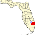
Lakewood Gardens, Florida

Last updated
Lakewood Gardens, Florida
USA Florida location map.svg
Red pog.svg
Lakewood Gardens, Florida
Coordinates: 26°37′18″N80°06′09″W / 26.62167°N 80.10250°W / 26.62167; -80.10250 Coordinates: 26°37′18″N80°06′09″W / 26.62167°N 80.10250°W / 26.62167; -80.10250
Country United States
State Florida
County Palm Beach
Area
[1]
  Total0.190 sq mi (0.49 km2)
  Land0.190 sq mi (0.49 km2)
  Water0 sq mi (0 km2)
Elevation
16 ft (5 m)
Population
 (2010) [2]
  Total1,273
  Density6,700/sq mi (2,600/km2)
Time zone UTC-5 (Eastern (EST))
  Summer (DST) UTC-4 (EDT)
Area code(s) 561
GNIS feature ID2628524 [3]

Lakewood Gardens was a census-designated place in Palm Beach County, Florida, United States. Its population was 1,273 as of the 2010 census. [2] In 2011, the area was annexed by the village of Palm Springs. [4]

Related Research Articles

Denver metropolitan area Metropolitan area in the United States

Denver is the central city of a conurbation region in the U.S. state of Colorado. The conurbation includes one continuous region consisting of the six central counties of Adams, Arapahoe, Broomfield, Denver, Douglas, and Jefferson. The Denver region is part of the Front Range Urban Corridor.

Flagler County, Florida County in Florida, United States

Flagler County is a county located on the northeastern coast of the U.S. state of Florida. As of the 2010 census, the population was 95,696. Its county seat is Bunnell. Created in 1917 from portions of Saint Johns and Volusia Counties, it was named for Henry Morrison Flagler, who built the Florida East Coast Railway.

June Park, Florida Census-designated place in Florida

June Park is a census-designated place (CDP) in Brevard County, Florida. The population was 4,094 at the 2010 United States Census. It is part of the Palm Bay–Melbourne–Titusville Metropolitan Statistical Area.

Palm River-Clair Mel, Florida Census-designated place in Florida, United States

Palm River-Clair Mel is a census-designated place (CDP) in Hillsborough County, Florida, United States. The population was 21,024 at the 2010 census, up from 17,589 at the 2000 census. The census area includes the unincorporated communities of Clair-Mel City and Palm River. The ZIP code for Palm River-Clair Mel is 33619.

Haverhill, Florida Town in Florida, United States

Haverhill is a town in Palm Beach County, Florida, United States. Haverhill became a town on May 3, 1950, and was named after the city of Haverhill, Massachusetts. The town has maintained a small population since its establishment. The 2010 census recorded a population of 1,873, while the population was estimated at 2,123 in 2018. Haverhill, located in east-central Palm Beach County near the western periphery of the Palm Beach International Airport, is also small geographically, encompassing just 0.63 square miles (1.6 km2).

East Lake, Pinellas County, Florida Census-designated place in Florida, United States

East Lake is a census-designated place (CDP) in Pinellas County, Florida, United States. The population was 30,962 at the 2010 census. It was one of the last areas in the densely populated county to develop. It is often confused with East Lake in neighboring Hillsborough County.

Lakewood, Washington City in Washington, United States

Lakewood is a city in Pierce County, Washington, United States. The population was 58,163 at the 2010 census.

A census-designated place (CDP) is a concentration of population defined by the United States Census Bureau for statistical purposes only. CDPs have been used in each decennial census since 1980 as the counterparts of incorporated places, such as self-governing cities, towns, and villages, for the purposes of gathering and correlating statistical data. CDPs are populated areas that generally include one officially designated but currently unincorporated community, for which the CDP is named, plus surrounding inhabited countryside of varying dimensions and, occasionally, other, smaller unincorporated communities as well. CDPs include small rural communities, colonias located along the Mexico–United States border, and unincorporated resort and retirement communities and their environs.

Aberdeen, Florida Census-designated place in Florida, United States

Aberdeen was a census-designated place (CDP) in Palm Beach County, Florida. The population was 2,672 at the 1990 census. It now serves as a neighborhood in the vast swathe of undifferentiated suburbia that is west of Boynton Beach, Florida. Although the Census Bureau no longer recognizes Aberdeen as a census-designated place, the neighborhood continues to exist and prosper.

Lakewood (CDP), New Jersey Census-designated place in New Jersey, United States

Lakewood is an unincorporated community and census-designated place (CDP) located within Lakewood Township, in Ocean County, New Jersey, United States. As of the 2010 United States Census, the CDP's population was 53,805.

Lakewood (CDP), Wisconsin Census-designated place in Wisconsin, United States

Lakewood is an unincorporated census-designated place located in the town of Lakewood, Oconto County, Wisconsin, United States. Lakewood is located on Wisconsin Highway 32 22 miles (35 km) north-northwest of Suring. Lakewood has a post office with ZIP code 54138. As of the 2010 census, its population was 323.

Dakota Ridge, Colorado Census-designated place in Colorado, United States

Dakota Ridge is a census-designated place (CDP) in Jefferson County, Colorado, United States. The population as of the 2010 census was 32,005.

Viera East is a census-designated place (CDP) in Brevard County, Florida, United States. The population was 10,757 at the 2010 census. It forms a part of the larger unincorporated community of Viera and is part of the Palm Bay–Melbourne–Titusville Metropolitan Statistical Area.

Viera West is a census-designated place (CDP) in Brevard County, Florida, United States. The population was 6,641 at the 2010 census. It forms a part of the larger unincorporated community of Viera and is part of the Palm Bay–Melbourne–Titusville Metropolitan Statistical Area.

San Castle, Florida Census-designated place in Florida, United States

San Castle is a census-designated place in Palm Beach County, Florida, United States. Its population was 3,428 as of the 2010 census. San Castle is located between Interstate 95 and the Intracoastal Waterway; it borders Lantana to the south, Hypoluxo to the west and Boynton Beach to the northeast.

Watergate, Florida Census-designated place in Florida, United States

Watergate is a census-designated place in Palm Beach County, Florida, United States. Its population was 2,942 as of the 2010 census. Watergate is located on the west side of U.S. Route 441, west of Boca Raton.

Cabana Colony, Florida Census-designated place in Florida, United States

Cabana Colony is a census-designated place in Palm Beach County, Florida, United States. Its population was 2,391 as of the 2010 census. Cabana Colony is located on the east side of State Road 811 and borders Palm Beach Gardens on three sides.

Acacia Villas, Florida Census-designated place in Florida, United States

Acacia Villas is a census-designated place in Palm Beach County, Florida, United States. Its population was 427 as of the 2010 census. Acacia Villas is located on the east side of State Road 809; it borders Palm Springs on its north, east, and south sides.

Kenwood Estates, Florida Census-designated place in Florida, United States

Kenwood Estates is a census-designated place in Palm Beach County, Florida, United States. Its population was 1,283 as of the 2010 census. Kenwood Estates is located between Greenacres and Palm Springs; State Road 809 passes through the community.

Pine Air, Florida Census-designated place in Florida, United States

Pine Air is a census-designated place in Palm Beach County, Florida, United States. Its population was 2,024 as of the 2010 census. Pine Air is bordered by State Road 809 to the west and the village of Palm Springs to the south.

References

  1. "2010 Census Gazetteer Files: Florida Places". U.S. Census Bureau. Archived from the original on March 5, 2014. Retrieved June 2, 2014.
  2. 1 2 "2010 Demographic Profile Data: Lakewood Gardens CDP, Florida". U.S. Census Bureau. Archived from the original on February 12, 2020. Retrieved June 2, 2014.
  3. "Lakewood Gardens Census Designated Place (historical)". Geographic Names Information System . United States Geological Survey.
  4. "Geographic Boundary Change Notes". U.S. Census Bureau . Retrieved June 2, 2014.