Kings Point, Florida

Last updated
Kings Point, Florida
FLMap-doton-KingsPoint.PNG
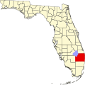
Location of Kings Point, Florida
Coordinates: 26°26′46″N80°8′23″W / 26.44611°N 80.13972°W / 26.44611; -80.13972 Coordinates: 26°26′46″N80°8′23″W / 26.44611°N 80.13972°W / 26.44611; -80.13972
Country Flag of the United States.svg  United States
State Flag of Florida.svg  Florida
County   Palm Beach
Area
  Total1.8 sq mi (4.7 km2)
  Land1.8 sq mi (4.7 km2)
  Water0.0 sq mi (0.0 km2)
Elevation
16 ft (5 m)
Population
 (2000)
  Total12,207
  Density6,698.5/sq mi (2,586.3/km2)
Time zone UTC-5 (Eastern (EST))
  Summer (DST) UTC-4 (EDT)
FIPS code 12-36812 [1]
GNIS feature ID1867160 [2]

Kings Point was a census-designated place (CDP) in Palm Beach County, Florida, United States, located west of Delray Beach. The population was 12,207 as of the 2000 census. The CDP consists primarily of a retirement community of the same name. The 2012 documentary Kings Point depicted the lives of some of the residents and was nominated for the Academy Award for Best Documentary (Short Subject). [3]

Contents

Geography

Kings Point is located at 26°26′46″N80°8′23″W / 26.44611°N 80.13972°W / 26.44611; -80.13972 (26.446044, -80.139715). [4]

According to the United States Census Bureau, the CDP has a total area of 4.7 km2 (1.8 mi2), all land.

Demographics

As of the census [1] of 2000, there were 12,207 people, 7,998 households, and 3,599 families living in the CDP. The population density was 2,589.6/km2 (6,698.5/mi2). There were 10,494 housing units at an average density of 2,226.2/km2 (5,758.5/mi2). The racial makeup of the CDP was 99.10% White (98.1% were non-Hispanic white), [5] 0.27% African American, 0.04% Native American, 0.18% Asian, 0.01% Pacific Islander, 0.08% from other races, and 0.32% from two or more races. Hispanic or Latino of any race were 1.13% of the population.

There were 7,998 households, out of which 0.1% had children under the age of 18 living with them, 42.0% were married couples living together, 2.2% had a female householder with no husband present, and 55.0% were non-families. 52.2% of all households were made up of individuals, and 47.6% had someone living alone who was 65 years of age or older. The average household size was 1.51 and the average family size was 2.05.

Of the residents, 0.2% were under the age of 18, 0.2% were 18 to 24, 1.8% were 25 to 44, 9.6% were 45 to 64, and 88.1% were 65 years of age or older. The median age was 78 years. For every 100 females age 18 and over, there were 67.0 males.

The median income for a household in the CDP was $25,010, and the median income for a family was $34,761. Males had a median income of $35,275 versus $25,714 for females. The per capita income for the CDP was $21,893. About 4.0% of families and 7.4% of the population were below the poverty line, including none of those under age 18 and 7.0% of those age 65 or over.

As of 2000, English was the first language for 87.54% of all residents, while Yiddish accounted for 7.06%, Italian 1.14%, Spanish 0.85%, German 0.69%, and Hungarian 0.53% of the population. [6]

Related Research Articles

<span class="mw-page-title-main">Carrick, California</span> Census-designated place in California

Carrick is a census-designated place (CDP) in Siskiyou County, California, United States. Its population is 143 as of the 2020 census, up from 131 from the 2010 census. Carrick is located just outside the town of Weed, uses Weed in its mailing addresses and is generally viewed by locals as a neighborhood of Weed, though located outside of the city proper. On September 15, 2014, Carrick was under mandatory evacuation order due to a forest fire.

Boulevard Gardens is a census-designated place (CDP) in Broward County, Florida, United States. The population was 1,274 at the 2010 census.

<span class="mw-page-title-main">Westview, Florida</span> CDP in Florida, United States

Westview is a census-designated place (CDP) in Miami-Dade County, Florida, United States. The population was 9,923 at the 2020 census.

Juno Ridge is a census-designated place (CDP) in Palm Beach County, Florida, United States. The population was 742 at the 2000 census.

<span class="mw-page-title-main">Fussels Corner, Florida</span> Census-designated place in Florida, United States

Fussels Corner is a census-designated place (CDP) in Polk County, Florida, United States. The population was 5,313 at time of the 2000 census. It is part of the Lakeland–Winter Haven Metropolitan Statistical Area.

<span class="mw-page-title-main">Putney, Georgia</span> Census–designated place and Unincorporated Community in Georgia, United States

Putney is a census-designated place (CDP) and unincorporated community in Dougherty County, Georgia, United States. The population was 2,898 at the 2010 census. It is part of the Albany, Georgia Metropolitan Statistical Area.

<span class="mw-page-title-main">Redland, Maryland</span> Census-designated place in Maryland, United States

Redland is a census-designated place and an unincorporated area in Montgomery County, Maryland, United States. It had a population of 18,592 as of the 2020 census.

<span class="mw-page-title-main">Kings Point, Montana</span> Census-designated place in Montana, United States

Kings Point is a census-designated place (CDP) in Lake County, Montana, United States. The population was 151 at the 2010 census, down from 169 in 2000.

<span class="mw-page-title-main">Pemberton Heights, New Jersey</span> Census-designated place in New Jersey, United States

Pemberton Heights is an unincorporated community and census-designated place (CDP) located within Pemberton Township, in Burlington County, New Jersey, United States. As of the 2010 United States Census, the CDP's population was 2,423.

<span class="mw-page-title-main">North New Hyde Park, New York</span> Hamlet and census-designated place in New York, United States

North New Hyde Park is a hamlet and census-designated place (CDP) in the Town of North Hempstead in Nassau County, on Long Island, in New York, United States. The population was 14,899 at the 2010 census.

<span class="mw-page-title-main">Kings Grant, North Carolina</span> CDP in North Carolina, United States

Kings Grant is a census-designated place (CDP) in New Hanover County, North Carolina, United States. The population was 8,113 at the 2010 census, up from 7,738 in 2000. It is part of the Wilmington Metropolitan Statistical Area.

<span class="mw-page-title-main">Atlantic, Pennsylvania</span> Census-designated place in Pennsylvania, United States

Atlantic is a census-designated place (CDP) in Crawford County, Pennsylvania, United States. The population was 77 at the 2010 census, up from 43 in 2000.

<span class="mw-page-title-main">Pymatuning Central, Pennsylvania</span> Census-designated place in Pennsylvania, United States

Pymatuning Central is a census-designated place (CDP) in Crawford County, Pennsylvania, United States. The population was 2,269 at the 2010 census.

<span class="mw-page-title-main">East Berwick, Pennsylvania</span> Census-designated place in Pennsylvania, United States

East Berwick is a census-designated place (CDP) in Salem Township, Luzerne County, Pennsylvania, United States. The population was 2,007 at the 2010 census.

<span class="mw-page-title-main">Cecil-Bishop, Pennsylvania</span> CDP in Pennsylvania, United States

Cecil-Bishop is a census-designated place (CDP) in Washington County, Pennsylvania, United States. The population was 2,476 at the 2010 census. The CDP is a merger of two unincorporated communities: larger Cecil in the east and smaller Bishop in the west.

<span class="mw-page-title-main">Gastonville, Pennsylvania</span> Census-designated place in Pennsylvania, United States

Gastonville is a census-designated place (CDP) in Washington County, Pennsylvania, United States. The population was 2,818 at the 2010 census.

<span class="mw-page-title-main">Wolfdale, Pennsylvania</span> Census-designated place in Pennsylvania, United States

Wolfdale is a census-designated place (CDP) in Washington County, Pennsylvania, United States. The population was 2,888 at the 2010 census.

<span class="mw-page-title-main">Fishersville, Virginia</span> CDP in Virginia, United States

Fishersville is a census-designated place (CDP) in Augusta County, Virginia, United States. The population was 7,462 at the 2010 census, an increase of nearly fifty percent from the 4,998 reported in 2000. It is part of the Staunton–Waynesboro Micropolitan Statistical Area. Fishersville is also home to Barren Ridge Vineyards, winner of the 2009 Best in Show wine at the Virginia State Fair.

<span class="mw-page-title-main">Sudley, Virginia</span> Census-designated place in Virginia, United States

Sudley is a census-designated place (CDP) in Prince William County, Virginia, United States. As of the 2010 census, Sudley comprises what in the 2000 census were the Sudley and West Gate CDPs. Sudley's population including West Gate was 16,203 at the 2010 census, and excluding West Gate was 7,719 at the 2000 census.

<span class="mw-page-title-main">McKinnon, Wyoming</span> Census-designated place in Sweetwater County, Wyoming, United States

McKinnon is a census-designated place (CDP) in Sweetwater County, Wyoming, United States. The population was 60 at the 2010 census.

References

  1. 1 2 "U.S. Census website". United States Census Bureau . Retrieved 2008-01-31.
  2. "US Board on Geographic Names". United States Geological Survey. 2007-10-25. Retrieved 2008-01-31.
  3. Winerip, Michael (March 9, 2013). "Kings Point, a Magic Kingdom for the Retirement Set". The New York Times . Retrieved 2021-08-26.
  4. "US Gazetteer files: 2010, 2000, and 1990". United States Census Bureau. 2011-02-12. Retrieved 2011-04-23.
  5. "Demographics of Kings Point, FL". MuniNetGuide.com. Archived from the original on 2008-05-25. Retrieved 2007-12-12.
  6. "MLA Data Center Results for Kings Point, Florida". Modern Language Association . Retrieved 2007-12-12.