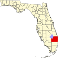
San Castle, Florida

Last updated

San Castle, Florida
USA Florida location map.svg
Red pog.svg
San Castle, Florida
Coordinates: 26°33′54″N80°03′40″W / 26.56500°N 80.06111°W / 26.56500; -80.06111
Country United States
State Florida
County Palm Beach
Area
[1]
  Total0.42 sq mi (1.09 km2)
  Land0.42 sq mi (1.09 km2)
  Water0.00 sq mi (0.00 km2)
Elevation
23 ft (7 m)
Population
 (2020)
  Total3,755
  Density8,940.48/sq mi (3,454.71/km2)
Time zone UTC-5 (Eastern (EST))
  Summer (DST) UTC-4 (EDT)
Area code 561
GNIS feature ID2628532 [2]

San Castle is an unincorporated community and census-designated place in Palm Beach County, Florida, United States. Its population was 3,755 as of the 2020 census. San Castle is located between Interstate 95 and the Intracoastal Waterway; it borders Lantana to the south, Hypoluxo to the west and Boynton Beach to the northeast. [3]

Contents

Demographics

Historical population
CensusPop.Note
2010 3,428
2020 3,7559.5%
U.S. Decennial Census [4]

As of 2016; San Castle, FL is home to a population of 4,358 people, from which 77.7% are citizens. The ethnic composition of the population of San Castle, FL is; Black or African American (49.3%), Hispanic or Latino (30.4%), White (19.5%), Asian (0.57%), Other (0.18%).

The most common foreign languages spoken in San Castle, FL are English at 50.4%, French Creole at 31%, Spanish at 18.3% and Chinese at 0.3%.

In 2015, the median household income of the 1,078 households in San Castle, FL grew to $49,107 from the previous year's value of $42,869. [5]

Crime

Despite its small size, the CDP has been notable for being home to the San Castle Soldiers, a set of the greater Top 6 gang; who was featured on the show Gangland, on the History Channel. The gang is notorious for being involved in the Christmas Eve shooting at the Boynton Beach Mall, which resulted in a death. [6] The gang was also involved in several other homicides. [7]

Related Research Articles

<span class="mw-page-title-main">St. Johns County, Florida</span> County in Florida, United States

St. Johns County is a county in the northeastern part of the U.S. state of Florida. As of the 2020 United States Census, its population was 273,425. The county seat and largest incorporated city is St. Augustine, although the largest community, St. Johns, is much larger. St. Johns County is part of the Jacksonville metropolitan area.

<span class="mw-page-title-main">Westmont, California</span> Place in California, United States

Westmont is an unincorporated community in Los Angeles County, California, a part of the South Los Angeles area, just east of Inglewood. The population was 33,913 at the 2020 census, up from 31,853 at the 2010 census. For statistical purposes, the United States Census Bureau has defined Westmont as a census-designated place (CDP).

<span class="mw-page-title-main">Moss Beach, California</span> Census designated place in California, United States

Moss Beach is a coastal census-designated place in San Mateo County, California, with a year 2020 census population of 3,214. Located in Moss Beach are the Fitzgerald Marine Reserve, a marine sanctuary; the Half Moon Bay Airport, the historic Moss Beach Distillery; and the Seal Cove Inn, a destination lodging property. Moss Beach is a cool coastal microclimate that gives one a sense of separation from the nearby metropolitan San Francisco Bay Area and assures that summer temperatures are generally mild.

<span class="mw-page-title-main">Melbourne Beach, Florida</span> Town in the state of Florida, United States

Melbourne Beach is a town in Brevard County, Florida. The population was 3,101 at the 2010 United States Census. It is part of the Palm Bay–Melbourne–Titusville Metropolitan Statistical Area.

<span class="mw-page-title-main">Deerfield Beach, Florida</span> City in Florida, United States

Deerfield Beach is a city in Broward County, Florida, United States, just south of the Palm Beach County line. The city is named for the numerous deer that once roamed the area. As of the 2020 census, the population was 86,859, making it the tenth-largest city in Broward County. It is a key suburb of the Miami metropolitan area, which was home to 6.14 million people in 2020.

<span class="mw-page-title-main">Boynton Beach, Florida</span> City in Florida, United States

Boynton Beach is a city in Palm Beach County, Florida, United States. It is situated about 57 miles (92 km) north of Miami. The 2020 census recorded a population of 80,380. Boynton Beach is a principal city of the Miami metropolitan area, which was home to 6,138,333 people at the 2020 census. The city is named after Nathan Boynton, a Civil War major and Michigan politician who became one of the first settlers in the area in 1895. Boynton Beach is located north of Delray Beach, south of Hypoluxo and Lantana, and east of Golf, while the municipalities of Briny Breezes, Gulf Stream, Manalapan, and Ocean Ridge are situated to the east across the Intracoastal Waterway.

<span class="mw-page-title-main">Canal Point, Florida</span> CDP in Florida, United States

Canal Point is a census-designated place (CDP) and unincorporated community in Palm Beach County, Florida, United States. Canal Point is located along the eastern shore of Lake Okeechobee, to the northeast of Pahokee and to the northwest of Bryant. The unincorporated community was originally inhabited by the Calusa tribe until almost 400 years ago. Whites began occupying the area in the 1900s decade, establishing an agrarian community. The completion of the West Palm Beach Canal in 1917 allowed crops to be shipped by boat to West Palm Beach and then to other areas of the country, while construction of Conners Highway in 1924 resulted in crops being transported by motor vehicle.

<span class="mw-page-title-main">Golf, Florida</span> Village in Florida, United States

The Village of Golf is a village in Palm Beach County, Florida, United States. As of 2020, the population recorded by the U.S. Census Bureau was 255. It's also part of South Florida's Miami metropolitan area.

Gun Club Estates is a census-designated place (CDP) in Palm Beach County, Florida, United States. The population was 816 at the 2020 census. The CDP is located in an unincorporated area near the southwest corner of the Palm Beach International Airport (PBI) and is bounded by West Palm Beach Canal on the north, Kirk Road on the east, Gun Club Road on the south, and Military Trail on the west.

<span class="mw-page-title-main">Lake Harbor, Florida</span> CDP in Florida, United States

Lake Harbor is a census-designated place (CDP) in Palm Beach County, Florida, United States. The population was 49 at the 2020 census. It located along the southern banks of Lake Okeechobee, at the beginning of the Miami Canal. John Stretch Park is also located alongside the north end of Lake Harbor and the lake.

Limestone Creek is a census-designated place (CDP) in Palm Beach County, Florida, United States. The population was 1,316 at the 2020 census.

<span class="mw-page-title-main">North Palm Beach, Florida</span> Village in Florida

North Palm Beach is an incorporated village in Palm Beach County, Florida, United States. It is part of the Miami Metropolitan Area. The population was 13,162 at the 2020 census. The village won an award from the National Association of Home Builders as best planned community of 1956. The North Palm Beach Country Club is home to a Jack Nicklaus Signature golf course.

<span class="mw-page-title-main">Ocean Ridge, Florida</span> Town in the state of Florida, United States

Ocean Ridge is a town in Palm Beach County, Florida, United States. The town is part of South Florida's Miami metropolitan area. The population was 1,830 at the 2020 US census.

Plantation Mobile Home Park is a census-designated place (CDP) in Palm Beach County, Florida, United States. The population was 1,462 at the 2020 census.

Schall Circle is a census-designated place (CDP) in Palm Beach County, Florida, United States. The population was 792 at the 2020 census.

<span class="mw-page-title-main">Nokomis, Florida</span> Census-designated place in Florida, United States

Nokomis is an unincorporated town in Sarasota County and a census-designated place (CDP) along the Gulf Coast of Florida, United States, located south of Osprey and just north of Venice. The town has access to the coast through Nokomis Public Beach and Casey Key. The town's population was 3,167 at the 2010 census. It is part of the Bradenton–Sarasota–Venice Metropolitan Statistical Area.

<span class="mw-page-title-main">Butler Beach, Florida</span> CDP in Florida, United States

Butler Beach is a census-designated place (CDP) in St. Johns County, Florida, United States. The population was 4,978 at the time of the 2020 United States Census.

<span class="mw-page-title-main">Crescent Beach, St. Johns County, Florida</span> CDP in Florida, United States

Crescent Beach is an unincorporated census-designated place in St. Johns County, Florida, United States. The population was 985 at the 2000 census.

<span class="mw-page-title-main">Vilano Beach, Florida</span> Census-designated place in Florida, United States

Vilano Beach is an unincorporated community in St. Johns County, Florida, United States. It was listed as the Villano Beach census-designated place (CDP) by the U.S. Census Bureau from 2010 to 1990; however, the name was corrected to Vilano Beach for the 2020 census. The population was 2,514 at the 2020 census.

<span class="mw-page-title-main">Miami metropolitan area</span> Metropolis in the U.S. state of Florida

The Miami metropolitan area, officially known as the Miami–Fort Lauderdale–Pompano Beach Metropolitan Statistical Area, is a coastal metropolitan area in the southeastern part of the state of Florida. It is the ninth-largest metropolitan statistical area in the United States, the fifth-largest in the Southern United States, and the largest in the state of Florida. With a population of 6.14 million, it has more people than 31 of the nation's 50 states as of 2022. It comprises the three most populated counties in the state: Miami-Dade County, Broward County, and Palm Beach County.

References

  1. "2020 U.S. Gazetteer Files". United States Census Bureau. Retrieved December 2, 2021.
  2. "San Castle Census Designated Place". Geographic Names Information System . United States Geological Survey, United States Department of the Interior.
  3. "Reference Maps". U.S. Census Bureau. Archived from the original on February 12, 2020. Retrieved June 3, 2014.
  4. "Census of Population and Housing". Census.gov. Retrieved June 4, 2016.
  5. "San Castle, FL". Data USA. Retrieved January 28, 2018.
  6. "Nights bring crime in San Castle". tribunedigital-sunsentinel. Retrieved January 28, 2018.
  7. "Gang-related homicides affiliated with the Top 6". tribunedigital-sunsentinel. Retrieved January 28, 2018.