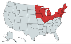
Northern United States

Last updated
Northern United States
Northern States in general.png
The states shown in red are each considered part of the Northern United States.
CountryUnited States
States Connecticut
Illinois
Indiana
Iowa
Maine
Massachusetts
Michigan
Minnesota
New Hampshire
New Jersey
New York
Ohio
Pennsylvania
Rhode Island
Vermont
Wisconsin
Subregions Northeastern United States
Midwestern United States
Area
[1]
  Total625,897.06 sq mi (1,621,065.9 km2)
  Land540,298.08 sq mi (1,399,365.6 km2)
Population
 (2019 est.) [2] [3]
  Total111,736,936
  Density180/sq mi (69/km2)
Demonym Northerner

The Northern United States, commonly referred to as the American North, the Northern States, or simply the North, is a geographical and historical region of the United States.

Contents

History

Early history

Before the 19th century westward expansion, the "Northern United States" corresponded to the present day New England region. By the 1830s it corresponded to the present day Northeast and Great Lakes region.

Before 1865, the North was distinguished from the South on the issue of slavery. In Southern states, slavery was legal until the ratification of the 13th Amendment in 1865. Northern states had all passed some form of legislation to abolish slavery by 1804. However, abolition did not mean freedom for some existing slaves. Due to gradual abolition laws, slaves would still appear in some Northern states as far as the 1840 United States Census. [4] New Jersey was the last Northern state to end slavery. Due to their states gradual abolition laws, slavery came to an end in New Jersey when the 13th Amendment was ratified in 1865. [5]

American Civil War

Map of the division of the states during the American Civil War (1861-1865); states in blue represent northern Union states, those in light blue representing five largely Union-supporting border southern states that permitted slavery, known as border states, and both Missouri and Kentucky, which had competing Confederate and Unionist governments, and states in red representing southern seceded states, known as the Confederate States of America prior to the end of the American Civil War US map 1864 Civil War divisions.svg
Map of the division of the states during the American Civil War (1861–1865); states in blue represent northern Union states, those in light blue representing five largely Union-supporting border southern states that permitted slavery, known as border states, and both Missouri and Kentucky, which had competing Confederate and Unionist governments, and states in red representing southern seceded states, known as the Confederate States of America prior to the end of the American Civil War

During the American Civil War (1861–1865), the Northern states comprised the U.S. states that supported the United States of America, referred to as the Union. In this context, "the North" is synonymous with the Union, while "the South" refers to the states that seceded from the U.S. in order to form the Confederate States of America.

There is, however, some historical disagreement as to exactly which states comprised the North in the context of the Civil War as five slave-holding states largely remained with the Union: the southern border states of Missouri, Kentucky, West Virginia, Maryland, and Delaware, along with the disputed Indian Territory, though Missouri and Kentucky had dual competing Confederate and Unionist governments with the Confederate government of Kentucky and the Confederate government of Missouri and the Confederacy controlled more than half of Kentucky and the southern portion of Missouri early in the war. The Confederacy largely lost control in both states after 1862; depending on the source, some of these states and territories may be included in either region. [6]

Geography

Geographically, the term includes the U.S. states and regions of the United States of America that are located across the northernmost part of the country. It includes states along the Canada–United States border.

Census Bureau

The United States Census Bureau divides some of the northernmost United States into the Midwest Region and the Northeast Region. [7] The U.S. Census Bureau also includes the northernmost states of the Northwest, that are within the West Region. [7]

Urban centers

Among the larger cities by population in the Northern United States are: New York City, Chicago, Philadelphia, Boston, Pittsburgh, Columbus, Indianapolis, Cleveland, Cincinnati, Minneapolis, St. Paul, Buffalo, Milwaukee, Detroit, and Des Moines.

The Northern United States also comprises most of the Northeast megalopolis, which is the most populated and urbanized megalopolis in the United States. The Great Lakes megalopolis is also located in the Northern United States, largely in the Great Lakes region and Midwest.

Climate

The Northern United States has a humid continental climate. Most of the Northern states have warm to hot summers and significant snowfall during the winter.

See also

Related Research Articles

<span class="mw-page-title-main">American Civil War</span> 1861–1865 conflict in the United States

The American Civil War was a civil war in the United States between the Union and the Confederacy, which had been formed by states that had seceded from the Union. The central cause of the war was the dispute over whether slavery would be permitted to expand into the western territories, leading to more slave states, or be prevented from doing so, which many believed would place slavery on a course of ultimate extinction.

<span class="mw-page-title-main">Confederate States of America</span> Unrecognized state in North America (1861–1865)

The Confederate States of America (CSA), commonly referred to as the Confederate States (C.S.), the Confederacy, or the South, was an unrecognized breakaway republic in the Southern United States that existed from February 8, 1861, to May 9, 1865. The Confederacy comprised eleven U.S. states that declared secession and warred against the United States during the American Civil War. The states are South Carolina, Mississippi, Florida, Alabama, Georgia, Louisiana, Texas, Virginia, Arkansas, Tennessee, and North Carolina.

<span class="mw-page-title-main">Emancipation Proclamation</span> 1862 executive order by U.S. President Abraham Lincoln freeing slaves in the South

The Emancipation Proclamation, officially Proclamation 95, was a presidential proclamation and executive order issued by United States President Abraham Lincoln on January 1, 1863, during the American Civil War. The Proclamation had the effect of changing the legal status of more than 3.5 million enslaved African Americans in the secessionist Confederate states from enslaved to free. As soon as slaves escaped the control of their enslavers, either by fleeing to Union lines or through the advance of federal troops, they were permanently free. In addition, the Proclamation allowed for former slaves to "be received into the armed service of the United States". The Emancipation Proclamation played a significant part in the end of slavery in the United States.

<span class="mw-page-title-main">1860 United States presidential election</span> 19th quadrennial U.S. presidential election

The 1860 United States presidential election was the 19th quadrennial presidential election, held on Tuesday, November 6, 1860. In a four-way contest, the Republican Party ticket of Abraham Lincoln and Hannibal Hamlin won a national popular plurality, a popular majority in the North where states already had abolished slavery, and a national electoral majority comprising only Northern electoral votes. Lincoln's election thus served as the main catalyst of the states that would become the Confederacy seceding from the Union. This marked the first time that a Republican was elected president. It was also the first presidential election in which both major party candidates were registered in the same home state; the others have been in 1904, 1920, 1940, 1944, and 2016.

<span class="mw-page-title-main">Southern United States</span> One of the four census regions of the US

The Southern United States is a geographic and cultural region of the United States of America. It is between the Atlantic Ocean and the Western United States, with the Midwestern and Northeastern United States to its north and the Gulf of Mexico and Mexico to its south.

<span class="mw-page-title-main">Slavery in the United States</span>

The legal institution of human chattel slavery, comprising the enslavement primarily of Africans and African Americans, was prevalent in the United States of America from its founding in 1776 until 1865, predominantly in the South. Slavery was established throughout European colonization in the Americas. From 1526, during the early colonial period, it was practiced in what became Britain's colonies, including the Thirteen Colonies that formed the United States. Under the law, an enslaved person was treated as property that could be bought, sold, or given away. Slavery lasted in about half of U.S. states until abolition in 1865, and issues concerning slavery seeped into every aspect of national politics, economics, and social custom. In the decades after the end of Reconstruction in 1877, many of slavery's economic and social functions were continued through segregation, sharecropping, and convict leasing.

<span class="mw-page-title-main">Confederate States Army</span> Southern army in the American Civil War

The Confederate States Army, also called the Confederate Army or the Southern Army, was the military land force of the Confederate States of America during the American Civil War (1861–1865), fighting against the United States forces to win the independence of the Southern states and uphold and expand the institution of slavery. On February 28, 1861, the Provisional Confederate Congress established a provisional volunteer army and gave control over military operations and authority for mustering state forces and volunteers to the newly chosen Confederate president, Jefferson Davis. Davis was a graduate of the U.S. Military Academy, and colonel of a volunteer regiment during the Mexican–American War. He had also been a United States senator from Mississippi and U.S. Secretary of War under President Franklin Pierce. On March 1, 1861, on behalf of the Confederate government, Davis assumed control of the military situation at Charleston, South Carolina, where South Carolina state militia besieged Fort Sumter in Charleston harbor, held by a small U.S. Army garrison. By March 1861, the Provisional Confederate Congress expanded the provisional forces and established a more permanent Confederate States Army.

<span class="mw-page-title-main">Border states (American Civil War)</span> Slave states that did not secede from the Union during the American Civil War

In the context of the American Civil War (1861–65), the border states were slave states that did not secede from the Union. They were Delaware, Maryland, Kentucky, and Missouri, and after 1863, the new state of West Virginia. To their north they bordered free states of the Union, and all but Delaware bordered slave states of the Confederacy to their south.

<span class="mw-page-title-main">Northeastern United States</span> One of the four census regions of the United States

The Northeastern United States, also referred to as the Northeast, the East Coast, or the American Northeast, is a geographic region of the United States located on the Atlantic coast of North America. It borders Canada to its north, the Southern United States to its south, the Midwestern United States to its west, and the Atlantic Ocean to its east.

<span class="mw-page-title-main">Slave states and free states</span> Historical division of United States in which slavery was legal or not

In the United States before 1865, a slave state was a state in which slavery and the internal or domestic slave trade were legal, while a free state was one in which they were prohibited. Between 1812 and 1850, it was considered by the slave states to be politically imperative that the number of free states not exceed the number of slave states, so new states were admitted in slave–free pairs. There were, nonetheless, some slaves in most free states up to the 1840 census, and the Fugitive Slave Clause of the U.S. Constitution, as implemented by the Fugitive Slave Act of 1793 and the Fugitive Slave Act of 1850, provided that a slave did not become free by entering a free state and must be returned to his or her owner.

<span class="mw-page-title-main">Solid South</span> 1877–1964 U.S. Democratic voting bloc

The Solid South or the Southern bloc was the electoral voting bloc of the states of the Southern United States for issues that were regarded as particularly important to the interests of Democrats in those states. The Southern bloc existed between the end of the Reconstruction era in 1877 and the passage of the Civil Rights Act of 1964. During this period, the Democratic Party overwhelmingly controlled southern state legislatures, and most local, state and federal officeholders in the South were Democrats. During the late 1800s and early 1900s, Southern Democrats disenfranchised blacks in all Southern states, along with a few non-Southern states doing the same as well. This resulted essentially in a one-party system, in which a candidate's victory in Democratic primary elections was tantamount to election to the office itself. White primaries were another means that the Democrats used to consolidate their political power, excluding blacks from voting in primaries.

<span class="mw-page-title-main">History of the United States (1849–1865)</span>

The history of the United States from 1849 to 1865 was dominated by the tensions that led to the American Civil War between North and South, and the bloody fighting in 1861-1865 that produced Northern victory in the war and ended slavery. At the same time industrialization and the transportation revolution changed the economics of the Northern United States and the Western United States. Heavy immigration from Western Europe shifted the center of population further to the North.

<span class="mw-page-title-main">History of the Southern United States</span>

The history of the Southern United States spans back thousands of years to the first evidence of human occupation. The Paleo-Indians were the first peoples to inhabit the Americas and what would become the Southern United States. By the time Europeans arrived in the 15th century, the region was inhabited by the Mississippian people, well known for their mound-building cultures, building some of the largest cities of the Pre-Columbian United States. European history in the region would begin with the earliest days of the exploration. Spain, France, and especially England explored and claimed parts of the region.

<span class="mw-page-title-main">Little Dixie (Missouri)</span> Region of Missouri

Little Dixie is a historic 13- to 17-county region along the Missouri River in central Missouri, United States. Its early Anglo-American settlers were largely migrants from the hemp and tobacco districts of Virginia, Kentucky, and Tennessee. They brought enslaved African Americans with them or purchased them as workers in the region. Because Southerners settled there first, the pre-Civil War culture of the region was similar to that of the Upper South. The area was also known as Boonslick country.

<span class="mw-page-title-main">Culture of the Southern United States</span> Culture and traditions in the southern United States

The culture of the Southern United States, Southern culture, or Southern heritage, is a subculture of the United States. From its many cultural influences, the South developed its own unique customs, dialects, arts, literature, cuisine, dance, and music. The combination of its unique history and the fact that many Southerners maintain—and even nurture—an identity separate from the rest of the country has led to it being one of the most studied and written-about regions of the United States.

<span class="mw-page-title-main">Missouri in the American Civil War</span> Events within the borders of the U.S. state between 1861 and 1865

During the American Civil War, Missouri was a hotly contested border state populated by both Union and Confederate sympathizers. It sent armies, generals, and supplies to both sides, maintained dual governments, and endured a bloody neighbor-against-neighbor intrastate war within the larger national war.

<span class="mw-page-title-main">Alabama in the American Civil War</span>

Alabama was central to the Civil War, with the secession convention at Montgomery, the birthplace of the Confederacy, inviting other slaveholding states to form a southern republic, during January–March 1861, and to develop new state constitutions. The 1861 Alabaman constitution granted citizenship to current U.S. residents, but prohibited import duties (tariffs) on foreign goods, limited a standing military, and as a final issue, opposed emancipation by any nation, but urged protection of African-American slaves with trials by jury, and reserved the power to regulate or prohibit the African slave trade. The secession convention invited all slaveholding states to secede, but only 7 Cotton States of the Lower South formed the Confederacy with Alabama, while the majority of slave states were in the Union. Congress had voted to protect the institution of slavery by passing the Corwin Amendment on March 4, 1861, but it was never ratified.

<span class="mw-page-title-main">Upland South</span> Geographic region in the Southern United States

The Upland South and Upper South are two overlapping cultural and geographic subregions in the inland part of the Southern United States. They differ from the Deep South and Atlantic coastal plain by terrain, history, economics, demographics, and settlement patterns.

The following outline is provided as an overview of and topical guide to the American Civil War:

<span class="mw-page-title-main">End of slavery in the United States</span> Review of the topic

From the late-18th to the mid-19th century, various states of the United States of America allowed the enslavement of human beings, most of whom had been transported from Africa during the Atlantic slave trade or were their descendants. The institution of chattel slavery was established in North America in the 16th century under Spanish colonization, British colonization, French colonization, and Dutch colonization.

References

  1. "United States Summary: 2010, Population and Housing Unit Counts, 2010 Census of Population and Housing" (PDF). United States Census Bureau. September 2012. pp. V–2, 1 & 41 (Tables 1 & 18). Retrieved February 7, 2014.
  2. "Annual Estimates of the Resident Population for the United States, Regions, States, District of Columbia, and Puerto Rico: April 1, 2020 to July 1, 2021" . Retrieved December 20, 2023.
  3. "Population, Population Change, and Estimated Components of Population Change: April 1, 2010 to July 1, 2019 (NST-EST2019-alldata)". Census.gov. United States Census Bureau. Archived from the original on January 26, 2020. Retrieved 8 February 2020.
  4. Klein, Christopher. (Feb 5, 2019). Deeper Roots of Northern Slavery Unearthed – HISTORY. Retrieved Jul 28, 2020.
  5. New Jersey, The Last Northern State to End Slavery – NJ.gov. nj.gov. Retrieved January 27, 2022.
  6. "the North (region, United States)". Encyclopædia Britannica Online. 2009. Retrieved 2009-10-27.
  7. 1 2 "Census Regions and Divisions of the United States" (PDF). United States Census Bureau. Archived from the original (PDF) on 2013-01-07. Retrieved 2009-10-27.