Historical regions of the United States

Last updated

National Atlas map of United States territorial acquisitions U.S. Territorial Acquisitions.png
National Atlas map of United States territorial acquisitions

The territory of the United States and its overseas possessions has evolved over time, from the colonial era to the present day. It includes formally organized territories, proposed and failed states, unrecognized breakaway states, international and interstate purchases, cessions, and land grants, and historical military departments and administrative districts. The last section lists informal regions from American vernacular geography known by popular nicknames and linked by geographical, cultural, or economic similarities, some of which are still in use today.

Contents

For a more complete list of regions and subdivisions of the United States used in modern times, see List of regions of the United States.

Map showing mid 17th century claims and land grant boundaries. Some colonies seen here are: Nova Scotia (NSc), Territory of Sagadahock (TS), First Province of Maine (Me), New Hampshire (NH), Plymouth (PC), Massachusetts Bay (MBC), New Netherland (NN), New Sweden (NSw), and Lord Baltimore's Land (Md; Maryland) Wpdms early grants 1621 1639.png
Map showing mid 17th century claims and land grant boundaries. Some colonies seen here are: Nova Scotia (NSc), Territory of Sagadahock (TS), First Province of Maine (Me), New Hampshire (NH), Plymouth (PC), Massachusetts Bay (MBC), New Netherland (NN), New Sweden (NSw), and Lord Baltimore's Land (Md; Maryland)
New World settlements of The Netherlands, collectively called New Netherland Nieuw Nederland.png
New World settlements of The Netherlands, collectively called New Netherland

Colonial era (before 1776)

The Massachusetts Bay Colony Masscolony.png
The Massachusetts Bay Colony
French settlements and forts in the so-called Illinois Country, 1763, which encompassed parts of the modern day states of Illinois, Missouri, Indiana and Kentucky) Wpdms illinois country settlements 1763.png
French settlements and forts in the so-called Illinois Country, 1763, which encompassed parts of the modern day states of Illinois, Missouri, Indiana and Kentucky)
A 1775 map of the German Coast, a historical region of present-day Louisiana located above New Orleans on the eastern bank of the Mississippi River Mapofgermancoast-1775.jpg
A 1775 map of the German Coast, a historical region of present-day Louisiana located above New Orleans on the eastern bank of the Mississippi River
Vandalia was the name of a proposed British colony located south of the Ohio River, primarily in what is now the U.S. states of West Virginia and eastern Kentucky Vandalia01.png
Vandalia was the name of a proposed British colony located south of the Ohio River, primarily in what is now the U.S. states of West Virginia and eastern Kentucky
A proposal for the creation of Westsylvania was largely deterred by the Revolutionary War Westsylvaniamap.png
A proposal for the creation of Westsylvania was largely deterred by the Revolutionary War

Thirteen Colonies

Pre-Revolutionary War regions

† - indicates failed legal entities

New England

Mid-Atlantic

Southern

Interior

Map showing North American territorial boundaries leading up to the American Revolution and the founding of the United States: British claims are indicated in red and pink, while Spanish claims are in orange and yellow. NorthAmerica1762-83.png
Map showing North American territorial boundaries leading up to the American Revolution and the founding of the United States: British claims are indicated in red and pink, while Spanish claims are in orange and yellow.

Far West

Unlike the land to the east, most of the land west of the Mississippi River was under French or Spanish rule until the first years of the 19th century.

Colonies settled but unrecognized

The Oregon Country. The dispute over Oregon, between Britain and the U.S., led to an uneasy, parallel governing of the territory for almost 30 years. Oregoncountry2.png
The Oregon Country. The dispute over Oregon, between Britain and the U.S., led to an uneasy, parallel governing of the territory for almost 30 years.
Seward's Folly. The controversial purchase of Alaska from Russia in 1867 turned out to be a great deal for the U.S. when the area proved to contain a treasure trove of natural resources. Map of USA AK full.png
Seward's Folly. The controversial purchase of Alaska from Russia in 1867 turned out to be a great deal for the U.S. when the area proved to contain a treasure trove of natural resources.
The Baton Rouge and Mobile Districts of Spanish West Florida, claimed by the United States, spanned parts of three later states. The Spanish province also included part of the present-day state of Florida. West Florida Map.png
The Baton Rouge and Mobile Districts of Spanish West Florida, claimed by the United States, spanned parts of three later states. The Spanish province also included part of the present-day state of Florida.

Colonies proposed but unrealized

Independent entities later joined to the Union

Regions purchased from foreign powers

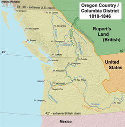
Regions annexed from or ceded by foreign powers

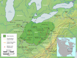
Ceded or purchased Native American regions

Progression of the two territorial governments, 1819-1836: Indian Territory is in teal; Arkansas is in dark green; western portion of Lovely's Purchase is in light green (to Indian Territory, 1828) Arkansasterritory.PNG
Progression of the two territorial governments, 1819–1836: Indian Territory is in teal; Arkansas is in dark green; western portion of Lovely's Purchase is in light green (to Indian Territory, 1828)
Indiana lands acquired through treaties Indiana Indian treaties.svg
Indiana lands acquired through treaties

Interstate, territorial, and federal cessions

The first state cessions. The 13 original states ceded their western claims to the federal government, allowing for the creation of the country's first western territories and states. United States land claims and cessions 1782-1802.png
The first state cessions. The 13 original states ceded their western claims to the federal government, allowing for the creation of the country's first western territories and states.

The following are state cessions made during the building of the U.S.

Former organized territories

The Northwest Territory was ceded by Great Britain to the United States at the end of the American Revolutionary War. Britain irrevocably ceded all claims to the territory in the 1814 Treaty of Ghent. Northwest Territory locator map (1787).svg
The Northwest Territory was ceded by Great Britain to the United States at the end of the American Revolutionary War. Britain irrevocably ceded all claims to the territory in the 1814 Treaty of Ghent.
United States territorial expansion since 1803, maps by William R. Shepherd (1923) USA Expansion since 1803.jpg
United States territorial expansion since 1803, maps by William R. Shepherd (1923)
Census Bureau map depicting territorial acquisitions and effective dates of statehood Territorial-acquisition-uscensus-bureau.jpg
Census Bureau map depicting territorial acquisitions and effective dates of statehood

The following is a list of the 31 U.S. territories that have become states, in the order of the date organized. (All were considered incorporated.)

Internal land grants, cessions, districts, departments, claims and settlements
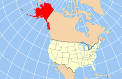
The Ohio Country, indicating battle sites between settlers and Native American Tribes, 1775-1794 Ohio Country en.png
The Ohio Country, indicating battle sites between settlers and Native American Tribes, 1775–1794

The following are land grants, cessions, defined districts (official or otherwise) or named settlements made within an area that was already part of a U.S. state or territory that did not involve international treaties or Native American cessions or land purchases.

Alaska

Colorado

Iowa

Nebraska

New York

Selected tract purchases of western New York State WNY5.PNG
Selected tract purchases of western New York State

Ohio

Map of the Ohio Lands Ohio Lands.svg
Map of the Ohio Lands

Oklahoma

Oklahoma Territory and Indian Territory, along with No Man's Land (also known as the Oklahoma Panhandle). The division of the two territories is shown with a heavy purple line. Together, these three areas would become the State of Oklahoma in 1907. Okterritory.png
Oklahoma Territory and Indian Territory, along with No Man's Land (also known as the Oklahoma Panhandle). The division of the two territories is shown with a heavy purple line. Together, these three areas would become the State of Oklahoma in 1907.

Indian reserves

Pennsylvania land purchases from Native Americans Pennsylvania land purchases.png
Pennsylvania land purchases from Native Americans

Pennsylvania

Federal military districts and departments

These entities were sometimes the only governmental authority in the listed areas, although they often co-existed with civil governments in scarcely populated states and territories. Civilian administered "military" tracts, districts, departments, etc., will be listed elsewhere.

Central United States

Pacific area

During the American Civil War, the Department of the Pacific had six subordinate military districts:

The Department of California (1858–1861) comprised the southern part of the Department of the Pacific: California, Nevada, and southern part of Oregon Territory; merged into the Department of the Pacific as the District of California.

The Department of Oregon (1858–1861) comprised the northern part of the Department of the Pacific: Washington Territory and Oregon Territory.

Post-Civil War military districts were set up to aid in the repatriation process of the southern states during Reconstruction. Reconstruction military districts.svg
Post-Civil War military districts were set up to aid in the repatriation process of the southern states during Reconstruction.

The south

The west

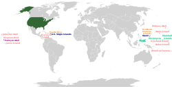
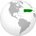
Retroceded possessions and overseas territories

The Panama Canal Zone was once a territory of the United States CanalZone.png
The Panama Canal Zone was once a territory of the United States

Functioning but non-sanctioned territories

The boundaries of the State of Deseret, as proposed in 1849 State of Deseret, vector image cropped - 2011.svg
The boundaries of the State of Deseret, as proposed in 1849

These "territories" had actual, functioning governments (recognized or not):

Animated map of secession and repatriation of the Confederacy, 1860-1870 United States 1860-1870.gif
Animated map of secession and repatriation of the Confederacy, 1860–1870

These are functioning governments created as a result of the attempted secession of the Confederacy during the American Civil War (1861–1865). Some were enclaves within enemy-held territories:

These were regions disassociated from neighboring areas due to opposing views:

Regional nicknames

Regions of the United States:
.mw-parser-output .legend{page-break-inside:avoid;break-inside:avoid-column}.mw-parser-output .legend-color{display:inline-block;min-width:1.25em;height:1.25em;line-height:1.25;margin:1px 0;text-align:center;border:1px solid black;background-color:transparent;color:black}.mw-parser-output .legend-text{}
New England
Mid-Atlantic
East North Central (Great Lakes, or Eastern Midwest)
West North Central (Western Midwest, or The Great Plains States)
South Atlantic
East South Central
West South Central
Mountain States
Pacific States US 9 regions.svg
Regions of the United States:
  New England
  Mid-Atlantic
  East North Central (Great Lakes, or Eastern Midwest)
  West North Central (Western Midwest, or The Great Plains States)
  South Atlantic
  East South Central
  West South Central
  Mountain States
  Pacific States

Belts

Belts are loosely defined sub-regions found throughout the United States that are named for a perceived commonality among the included areas, which is often related to the region's economy or climate.

See also

Related Research Articles

<span class="mw-page-title-main">Mexican Cession</span> Land the U.S. acquired from Mexico following the war in 1848

The Mexican Cession is the region in the modern-day western United States that Mexico previously controlled, then ceded to the United States in the Treaty of Guadalupe Hidalgo in 1848 after the Mexican–American War. This region had not been part of the areas east of the Rio Grande that had been claimed by the Republic of Texas, though the Texas annexation resolution two years earlier had not specified the southern and western boundary of the new state of Texas. At roughly 529,000 square miles (1,370,000 km2), not including any Texas lands, the Mexican Cession was the third-largest acquisition of territory in U.S. history, surpassed only by the 827,000-square-mile (2,140,000 km2) Louisiana Purchase and the 586,000-square-mile (1,520,000 km2) Alaska Purchase.

<span class="mw-page-title-main">Wyoming Territory</span> Former organized incorporated territory of the United States (1868–1890)

The Territory of Wyoming was an organized incorporated territory of the United States that existed from July 25, 1868, until July 10, 1890, when it was admitted to the Union as the State of Wyoming. Cheyenne was the territorial capital. The boundaries of the Wyoming Territory were identical to those of the modern State of Wyoming.

<span class="mw-page-title-main">Missouri Territory</span> Territory of the United States of America from 1812 to 1821

The Territory of Missouri was an organized incorporated territory of the United States that existed from June 4, 1812, until August 10, 1821. In 1819, the Territory of Arkansas was created from a portion of its southern area. In 1821, a southeastern portion of the territory was admitted to the Union as the State of Missouri, and the rest became unorganized territory for several years.

<span class="mw-page-title-main">United States National Register of Historic Places listings</span> Register for landmarks in the United States

The National Register of Historic Places in the United States is a register including buildings, sites, structures, districts, and objects. The Register automatically includes all National Historic Landmarks as well as all historic areas administered by the U.S. National Park Service. Since its introduction in 1966, more than 90,000 separate listings have been added to the register.

The trans-Mississippi theater of the American Civil War was the scene of the major military operations west of the Mississippi River. The area is often thought of as excluding the states and territories bordering the Pacific Ocean, which formed the Pacific coast theater of the American Civil War (1861–1865).

The Department of the West, later known as the Western Department, was a major command (Department) of the United States Army during the 19th century. It oversaw the military affairs in the country west of the Mississippi River to the borders of California and Oregon.

The timeline of Kansas details past events that happened in what is present day Kansas. Located on the eastern edge of the Great Plains, the U.S. state of Kansas was the home of sedentary agrarian and hunter-gatherer Native American societies, many of whom hunted American bison. The region first appears in western history in the 16th century at the time of the Spanish conquest of the Aztec Empire, when Spanish conquistadors explored the unknown land now known as Kansas. It was later explored by French fur trappers who traded with the Native Americans. It became part of the United States in the Louisiana Purchase of 1803. In the 19th century, the first American explorers designated the area as the "Great American Desert."

The following outline is provided as an overview of and a topical guide to the history of the United States.

<span class="mw-page-title-main">Outline of Iowa</span> Overview of and topical guide to Iowa

The following outline is provided as an overview of and topical guide to the U.S. state of Iowa.

<span class="mw-page-title-main">Outline of North Dakota</span> Overview of and topical guide to North Dakota

The following outline is provided as an overview of and topical guide to the U.S. state of North Dakota:

<span class="mw-page-title-main">Outline of Wyoming</span> Overview of and topical guide to Wyoming

The following outline is provided as an overview of and topical guide to the U.S. state of Wyoming:

<span class="mw-page-title-main">Outline of Wyoming territorial evolution</span>

The following outline traces the territorial evolution of the U.S. State of Wyoming.

<span class="mw-page-title-main">Territorial evolution of Montana</span>

The following chronology traces the territorial evolution of the U.S. State of Montana.

<span class="mw-page-title-main">Territorial evolution of North America since 1763</span> Timeline of notable events

The 1763 Treaty of Paris ended the major war known by Americans as the French and Indian War and by Canadians as the Seven Years' War / Guerre de Sept Ans, or by French-Canadians, La Guerre de la Conquête. It was signed by Great Britain, France and Spain, with Portugal in agreement. Preferring to keep Guadeloupe, France gave up Canada and all of its claims to territory east of the Mississippi River to Britain. With France out of North America this dramatically changed the European political scene on the continent.

There have been many United States historical military districts. Domestically, the United States Armed Forces has had military districts ranging from 1798 to 1881. They were reorganized several times: in 1800, in 1813, in 1815, in 1821, in 1837, in 1844, in 1848, in 1861, and in 1865. Internationally, military districts included Cuba, the Allied Military Government of Occupied Territories, South Korea, the Trust Territory of the Pacific Islands, and the Ryukyu Islands of Japan.

References

  1. "Luisiana". Artifacts.org. Retrieved 2012-09-17.
  2. Heidler, David Stephen; Heidler, Jeanne T.; Coles, David J.; Encyclopedia of the American Civil War: A Political, Social, and Military History; W. W. Norton & Company; New York; 2000; p. 590.