
Forest Hills is a city in Davidson County, Tennessee. The population was 5,038 at the 2010 census and 4,866 in a 2018 estimate.
The Pulteney Association was a small group of British investors who in 1792 purchased a large portion of the Western New York land tract known as the Phelps and Gorham Purchase. The Pulteney Associates were Sir William Pulteney, 5th Baronet (1729–1805), a Scottish lawyer who owned nine-twelfths; William Hornby, former Governor of Bombay, who owned two-twelfths; and Patrick Colquhoun, a Scottish merchant with a one-twelfth share. Some of their heirs owned land in western New York into the 1920s, with the last parcel of The Pulteney Association property, 10 acres, being sold in December 1926.
The Waldo Patent, a letters patent also known as the Muscongus Patent or the Lincolnshire Patent, was a document granting title to 36 square miles (9,300 ha) of land in what is now the U.S. state of Maine. It is named variously for businessman Samuel Waldo, who eventually gained control of the patent, and for the Muscongus River, one of the grant's boundaries.

The Holland Land Company was an unincorporated syndicate of thirteen Dutch investors from Amsterdam, headquartered in Philadelphia, who purchased large tracts of American land for development and speculation. Their primary purchase was that of the western two-thirds of the Phelps and Gorham Purchase in 1792 and 1793, an area that afterward was known as the Holland Purchase. Additional lands were purchased in northwest Pennsylvania. Aliens were forbidden from owning land within New York State, except by special acts of the New York State Legislature, so investors placed their funds in the hands of certain trustees who bought the land in central and western New York State. The syndicate hoped to sell the land rapidly at a great profit. Instead, for many years they were forced to make further investments in their purchase; surveying it, building roads, digging canals, to make it more attractive to settlers. They influenced state policy in New York to allow foreign ownership of the land, avoid new taxes, and promote the construction of the Erie Canal and government roads on the company lands. They supported Governor Dewitt Clinton's faction in the state government to achieve these goals. The company finished selling its New York lands in 1839 and its Pennsylvania lands in 1849, and the company was liquidated in 1858.

The Phelps and Gorham Purchase was the purchase in 1788 of 6,000,000 acres (24,000 km2) of land in what is now western New York State from the Commonwealth of Massachusetts for $1,000,000 (£300,000), to be paid in three annual installments, and the pre-emptive right to the title on the land from the Six Nations of the Iroquois Confederacy for $5000 (£12,500). A syndicate formed by Oliver Phelps and Nathaniel Gorham bought preemptive rights to the 9,600-square-mile (25,000 km2) parcel - larger than six present U.S. states: Vermont, New Hampshire, New Jersey, Connecticut, Delaware, and Rhode Island - in New York, west of Seneca Lake between Lake Ontario and the Pennsylvania border, from the Commonwealth of Massachusetts.

The Welsh Tract, also called the Welsh Barony, was a portion of the U.S. state of Pennsylvania settled largely by Welsh-speaking Quakers. It is located to the west of Philadelphia. The original settlers, led by John Roberts, negotiated with William Penn in 1684 to constitute the Tract as a separate county whose local government would use the Welsh language. The Barony was never formally created, but the many Welsh settlers gave their communities Welsh names that survive today. A more successful attempt at setting up a Gwladfa occurred two centuries later, in the Chubut Province of Patagonia, Argentina.

The Province of Pennsylvania, also known as the Pennsylvania Colony, was a British North American colony founded by William Penn, who received the land through a grant from Charles II of England in 1681. The name Pennsylvania was derived from "Penn's Woods", referring to William's father Admiral Sir William Penn.

The territory of the United States and its overseas possessions has evolved over time, from the colonial era to the present day. It includes formally organized territories, proposed and failed states, unrecognized breakaway states, international and interstate purchases, cessions, and land grants, and historical military departments and administrative districts. The last section lists informal regions from American vernacular geography known by popular nicknames and linked by geographical, cultural, or economic similarities, some of which are still in use today.

The Yazoo land scandal, Yazoo fraud, Yazoo land fraud, or Yazoo land controversy was a massive real-estate fraud perpetrated, in the mid-1790s, by Georgia governor George Mathews and the Georgia General Assembly. Georgia politicians sold large tracts of territory in the Yazoo lands, in what are now portions of the present-day states Alabama and Mississippi, to political insiders at very low prices in 1794. Although the law enabling the sales was overturned by reformers the following year, its ability to do so was challenged in the courts, eventually reaching the US Supreme Court. In the landmark decision in Fletcher v. Peck (1810), the Court ruled that the contracts were binding and the state could not retroactively invalidate the earlier land sales. It was one of the first times the Supreme Court had overturned a state law, and it justified many claims for those lands. Some of the land sold by the state in 1794 had been shortly thereafter resold to innocent third parties, greatly complicating the litigation. In 1802, because of the ongoing controversy, Georgia ceded all of its claims to lands west of its modern border to the U.S. government. In exchange the government paid cash and assumed the legal liabilities. Claims involving the land purchases were not fully resolved until legislation was passed in 1814 established a claims-resolution fund.

Six Nations is demographically the largest First Nations reserve in Canada. As of the end of 2017, it has a total of 27,276 members, 12,848 of whom live on the reserve. It is the only reserve in North America that has representatives of all six Haudenosaunee nations living together. These nations are the Mohawk, Cayuga, Onondaga, Oneida, Seneca and Tuscarora. Some Lenape also live in the territory.
William Bingham was an American statesman from Philadelphia. He was a delegate for Pennsylvania to the Continental Congress from 1786 to 1788 and served in the United States Senate from 1795 to 1801. Bingham was one of the wealthiest men in the United States during his lifetime, and was considered to be the richest person in the U.S. in 1780.

The Ohio Company of Associates, also known as the Ohio Company, was a land company whose members are today credited with becoming the first non-Native American group to permanently settle west of the Allegheny mountains. In 1788 they established Marietta, Ohio, as the first permanent settlement of the new United States in the newly organized Northwest Territory.

The Spanish and Mexican governments made many concessions and land grants in Alta California and Baja California from 1775 to 1846. The Spanish Concessions of land were made to retired soldiers as an inducement for them to remain in the frontier. These Concessions reverted to the Spanish crown upon the death of the recipient. The Mexican government later encouraged settlement by issuing much larger land grants to both native-born and naturalized Mexican citizens. The grants were usually two or more square leagues, or 35 square kilometres (14 sq mi) in size. Unlike Spanish Concessions, Mexican land grants provided permanent, unencumbered ownership rights. Most ranchos granted by Mexico were located along the California coast around San Francisco Bay, inland along the Sacramento River, and within the San Joaquin Valley.

New Barbadoes Neck is the name given in the colonial era for the peninsula in northeastern New Jersey, US between the lower Hackensack and Passaic Rivers, in what is now western Hudson County and southern Bergen County. The neck begins in the south at Kearny Point in the Newark Bay and is characterized by a ridge along the west and part of the New Jersey Meadowlands on the east.
A Half-Breed Tract was a segment of land designated in the western states by the United States government in the 19th century specifically for Métis of American Indian and European or European-American ancestry, at the time commonly known as half-breeds. The government set aside such tracts in several parts of the Midwestern prairie region, including in Iowa Territory, Nebraska Territory, Kansas Territory, Minnesota Territory, and Wisconsin Territory.
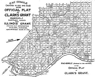
Clark's Grant was a tract of land granted in 1781 to George Rogers Clark and the soldiers who fought with him during the American Revolutionary War by the state of Virginia in honor of their service. The tract was 150,000 acres (610 km2) and located in present-day Clark County, Indiana, and parts of the surrounding counties.

The Congress Lands East of Scioto River was a land tract in southern Ohio that was established by the Congress late in the 18th century. It is located south of the United States Military District and Refugee Tract, west of the Old Seven Ranges, east of the Virginia Military District and north of the Ohio River, French Grant, and the Ohio Company of Associates.

The Equivalent Lands were several large tracts of land that the Province of Massachusetts Bay made available to settlers from the Connecticut Colony after April 1716. This was done as compensation for an equivalent area of territory that was under Connecticut's jurisdiction but had been inadvertently settled by citizens of Massachusetts. The problem had arisen due to errors and imprecise surveys made earlier in the seventeenth century. The Equivalent Lands were never mapped.

Bingham is a town in Somerset County, Maine, in the United States. The population was 866 at the 2020 census. Bingham is a historic town located beside the Kennebec River.