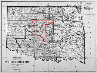
Big Pasture (Grazing Land Reservation No. 1) 1905.
The Big Pasture was 488,000 acres (1,975km2) of prairie land, in what is now southwestern Oklahoma. The land had been reserved for grazing use by the Kiowa, Comanche, and Apache tribes after their reserve was opened for settlement by a lottery conducted during June through August 1901. The tribes, however, leased most of the land out to large ranchers and it became known as Big Pasture. The Big Pasture was maintained for grazing until June 5, 1906, when Congress passed an act (Chapter 2580, 34 Stat. 213) requiring that it be disposed of by allotting 160 acres (0.6km2), in severalty, to each child born into the tribes after the act of 1900. The remaining land was sold by sealed bid in December 1906 and the proceeds placed in the U.S. Treasury for the tribes. This was the last large tract of land opened for settlement in Oklahoma Territory.
Oklahoma is a state in the South Central region of the United States, bordered by Kansas on the north, Missouri on the northeast, Arkansas on the east, Texas on the south, New Mexico on the west, and Colorado on the northwest. It is the 20th-most extensive and the 28th-most populous of the fifty United States. The state's name is derived from the Choctaw words okla and humma, meaning "red people". It is also known informally by its nickname, "The Sooner State", in reference to the non-Native settlers who staked their claims on land before the official opening date of lands in the western Oklahoma Territory or before the Indian Appropriations Act of 1889, which dramatically increased European-American settlement in the eastern Indian Territory. Oklahoma Territory and Indian Territory were merged into the State of Oklahoma when it became the 46th state to enter the union on November 16, 1907. Its residents are known as Oklahomans, and its capital and largest city is Oklahoma City.
Grazing is a method of feeding in which a herbivore feeds on plants such as grasses, or other multicellular organisms such as algae. In agriculture, grazing is one method used whereby domestic livestock are used to convert grass and other forage into meat, milk and other products.
Kiowa people are a Native American tribe and an indigenous people of the Great Plains. They migrated southward from western Montana into the Rocky Mountains in Colorado in the 17th and 18th centuries, and finally into the Southern Plains by the early 19th century. In 1867, the Kiowa were moved to a reservation in southwestern Oklahoma.
If newspaper accounts are to be believed, Coronado crossed the middle of the Big Pasture in his search for Quivira[1]
The Big Pasture was the scene of a well publicized wolf hunt by Theodore Roosevelt in 1905. He especially wanted to see John "Jack (Catch 'm Alive)" Abernathy from Frederick catch wolves with his bare hands. This hunt and his visit with Quanah Parker are often cited as reasons for his determination to create the nearby Wichita Mountain Wildlife Refuge and to return buffalo to the wild. The Wichita Mountains had previously been designated only as a Forest Preserve when first put under protection by William McKinley in 1901.
Theodore Roosevelt Jr. was an American statesman, sportsman, conservationist and writer who served as the 26th president of the United States from 1901 to 1909. He previously served as the 25th vice president of the United States from March to September 1901 and as the 33rd governor of New York from 1899 to 1900. As a leader of the Republican Party during this time, he became a driving force for the Progressive Era in the United States in the early 20th century. His face is depicted on Mount Rushmore, alongside those of George Washington, Thomas Jefferson, and Abraham Lincoln. In polls of historians and political scientists, Roosevelt is generally ranked as one of the five best presidents.
Frederick is a city and county seat of Tillman County, Oklahoma, United States. Once titled "The Friendly City", its charm and receptiveness leaves visitors feeling like locals. The population was 3,940 at the 2010 census. It is an agriculture-based community that primarily produces wheat, cotton, and cattle. Frederick is home to three dairies, a 1400-acre industrial park, and Frederick Regional Airport, which includes restored World War II hangars which house the World War II Airborne Demonstration Team.
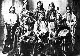
Quanah Parker was a war leader of the Quahadi ("Antelope") band of the Comanche Nation. He was born into the Nokoni ("Wanderers") band, the son of Comanche chief Peta Nocona and Cynthia Ann Parker, an Anglo-American, who had been kidnapped as a child and assimilated into the tribe. Following the apprehension of several Kiowa chiefs in 1871, Quanah emerged as a dominant figure in the Red River War, clashing repeatedly with Colonel Ranald S. Mackenzie. With European-Americans deliberately hunting American bison, the Comanches' primary sustenance, into extinction, Quanah eventually surrendered and peaceably led the Quahadi to the reservation at Fort Sill, Oklahoma.
Geography
The Big Pasture covered a strip of land 29 miles (47km) north and south and 36 miles (58km) east and west in what is now parts of Comanche, Cotton and Tillman counties. The towns of Randlett, Devol, Grandfield, Loveland, and Hollister (from east to west) are located in what was the Big Pasture. Randlett is home to Big Pasture Public Schools, a consolidated school system serving Devol, Cookietown, and Randlett.
Comanche County is a county located in the U.S. state of Oklahoma. As of the 2010 census, the population was 124,098, making it the fourth-most populous county in Oklahoma. Its county seat is Lawton. The county was created in 1901 as part of Oklahoma Territory. It was named for the Comanche tribe.
Cotton County is a county located in the U.S. state of Oklahoma. As of the 2010 census, the population was 6,193. Its county seat is Walters. When Oklahoma achieved statehood in 1907, the area which is now Cotton County fell within the boundaries of Comanche County. It was split off in 1912, becoming the last county created in Oklahoma; it was named for the county's primary crop.
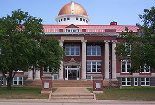
Tillman County is a county located in the southwestern part of Oklahoma. As of the 2010 census, the population was 7,992. The county seat is Frederick.
Before settlement, the Big Pasture was mostly plains cut by two timbered draws. Captain Randolph B. Marcy in his Red River expedition in 1852 noted that the timbered regions he found along Cache Creek were the last of any size until he reached the foothills of the Rockies.
Randolph Barnes Marcy was an officer in the United States Army, chiefly noted for his frontier guidebook, the Prairie Traveler (1859), based on his own extensive experience of pioneering in the west. This publication became a key handbook for the thousands of Americans wanting to cross the continent. In the Civil War, Marcy became chief of staff to his son-in-law George B. McClellan, and was later appointed Inspector General of the U.S. Army.
Footnotes
↑ Cooper, Chronicles of Oklahoma, 1957: "The Temple Tribune [Oklahoma], August 22, 1907, Eschiti, Oklahoma.—While excavating on a right-of-way near here a party of scraper drivers unearthed a historic tombstone that appears to have been set in a graveyard that once existed here. On the front of the marble slab is an inscription printed in undiscernable Spanish, above the inscription being the name, 'Don Juan Valerez El Padre, Madrid Senor de la Bonito Senorito.' Beneath the inscription is the date, '1542.'"
Bibliography
Cooper, Charles M. "The Big Pasture" Chronicles of Oklahoma 35:2 (April 1957) 138-146 (retrieved August 16, 2006).
This page is based on this Wikipedia article Text is available under the CC BY-SA 4.0 license; additional terms may apply. Images, videos and audio are available under their respective licenses.
Related Research Articles
As general terms, Indian Territory, the Indian Territories, or Indian country describe an evolving land area set aside by the United States Government for the relocation of Native Americans who held aboriginal title to their land. In general, the tribes ceded land they occupied in exchange for land grants in 1803. The concept of an Indian Territory was an outcome of the 18th- and 19th-century policy of Indian removal. After the Civil War (1861–1865), the policy of the government was one of assimilation.
Anadarko is a city in Caddo County, Oklahoma, United States. This city is fifty miles southwest of Oklahoma City. The population was 6,762 at the 2010 census, a 1.8 percent gain from 6,645 at the 2000 census. It is the county seat of Caddo County.
The city of Lawton is the county seat of Comanche County, in the State of Oklahoma. Located in southwestern Oklahoma, about 87 mi (140 km) southwest of Oklahoma City, it is the principal city of the Lawton, Oklahoma Metropolitan Statistical Area. According to the 2010 census, Lawton's population was 96,867, making it the fifth-largest city in the state.
Devol is a town in Cotton County, Oklahoma, United States. The population was 151 at the 2010 census, an increase of 0.7 percent from 150 at the 2000 census. The town is named for J. Fiske Devol, who owned the land on which it stands.
Randlett is a town in Cotton County, Oklahoma, United States. The population was 438 at the 2010 census, a decline of 14.3 percent from 511 at the 2000 census.
Grandfield is a city in Tillman County, Oklahoma, United States. The population was 1,038 at the 2010 census.
Land run usually refers to a historical event in which previously restricted land of the United States was opened to homestead on a first-arrival basis. Lands were opened and sold first-come or by bid, or won by lottery, or by means other than a run. The settlers, no matter how they acquired occupancy, purchased the land from the United States Land Office. For former Indian lands, the Land Office distributed the sales funds to the various tribal entities, according to previously negotiated terms. The Oklahoma Land Rush of 1889 was the most prominent of the land runs while the Land Run of 1893 was the largest. The opening of the former Kickapoo area in 1895 was the last use of a land run in the present area of Oklahoma.
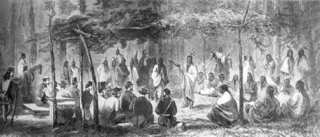
The Medicine Lodge Treaty is the overall name for three treaties signed between the Federal government of the United States and southern Plains Indian tribes in October 1867, intended to bring peace to the area by relocating the Native Americans to reservations in Indian Territory and away from European-American settlement. The treaty was negotiated after investigation by the Indian Peace Commission, which in its final report in 1868 concluded that the wars had been preventable. They determined that the United States government and its representatives, including the United States Congress, had contributed to the warfare on the Great Plains by failing to fulfill their legal obligations and to treat the Native Americans with honesty.
The Unassigned Lands in Oklahoma were in the center of the lands ceded to the United States by the Creek (Muskogee) and Seminole Indians following the Civil War and on which no other tribes had been settled. By 1883 it was bounded by the Cherokee Outlet on the north, several relocated Indian reservations on the east, the Chickasaw lands on the south, and the Cheyenne-Arapaho reserve on the west. The area amounted to 1,887,796.47 acres.
Fort Reno is a former United States Army cavalry post west of El Reno, Oklahoma. It is named for General Jesse L. Reno, who died at the Battle of South Mountain in the American Civil War.
Lone Wolf v. Hitchcock, 187 U.S. 553 (1903), was a United States Supreme Court case brought against the US government by the Kiowa chief Lone Wolf, who charged that Native American tribes under the Medicine Lodge Treaty had been defrauded of land by Congressional actions in violation of the treaty.
Indian removals in Indiana followed a series of the land cession treaties made between 1795 and 1846 that led to the removal of most of the native tribes from Indiana. Some of the removals occurred prior to 1830, but most took place between 1830 and 1846. The Lenape (Delaware), Piankashaw, Kickapoo, Wea, and Shawnee were removed in the 1820s and 1830s, but the Potawatomi and Miami removals in the 1830s and 1840s were more gradual and incomplete, and not all of Indiana’s Native Americans voluntarily left the state. The most well-known resistance effort in Indiana was the forced removal of Chief Menominee and his Yellow River band of Potawatomi in what became known as the Potawatomi Trail of Death in 1838, in which 859 Potawatomi were removed to Kansas and at least forty died on the journey west. The Miami were the last to be removed from Indiana, but tribal leaders delayed the process until 1846. Many of the Miami were permitted to remain on land allotments guaranteed to them under the Treaty of St. Mary's (1818) and subsequent treaties.
The Treaty of Fort Wayne was a treaty between the United States and several groups of Native Americans. The treaty was signed on June 7, 1803 and proclaimed December 26, 1803. It more precisely defined the boundaries of the Vincennes tract ceded to the United States by the Treaty of Greenville, 1795.
The History of Lawton, Oklahoma refers to the history of the southwestern Oklahoma city of Lawton, Oklahoma. Lawton's history starts with opening of American Indian reservation lands in the early 1900s and has seen population and economic growth throughout the 20th Century due to its proximity with Fort Sill.
The Tonkawa massacre occurred after an attack at the Confederate held Wichita Agency, located at Fort Sill near Anadarko in Oklahoma, when a force of pro-Union tribes attacked the agency, home to 300 members of the Tonkawa, a tribe sympathetic to the Confederacy. During the attack on the Confederate held agency, the Confederate Indian agent Matthew Leeper and several other whites were killed. In response to this attack the Tonkawa fled southward toward Confederate held Fort Arbuckle, before they could reach the safety of the fort they were caught on October 24. In the resulting massacre, the estimates of Tonkawa dead are 137 men, women and children among them Chief Ha-shu-ka-na, the Tonkawa were roasted alive and eaten by the ruthless Comanche. There are varying accounts of the tribes involved in the massacre with the Osage, Shawnee, Caddo, Comanche, Kiowa, Wichita and Seminole being named in some accounts.
The Cherokee Commission, was a three-person bi-partisan body created by President Benjamin Harrison to operate under the direction of the Secretary of the Interior, as empowered by Section 14 of the Indian Appropriations Act of March 2, 1889. Section 15 of the same Act empowered the President to open land for settlement. The Commission's purpose was to legally acquire land occupied by the Cherokee Nation and other tribes in the Oklahoma Territory for non-indigenous homestead acreage.