Cotton County, Oklahoma

Last updated

Cotton County
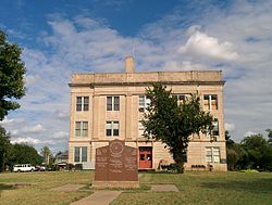
Cotton County Courthouse.jpg
Cotton County Courthouse in September 2014
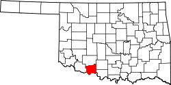
Map of Oklahoma highlighting Cotton County.svg
Location within the U.S. state of Oklahoma
Oklahoma in United States.svg
Oklahoma's location within the U.S.
Coordinates: 34°17′N98°22′W / 34.28°N 98.37°W / 34.28; -98.37
CountryFlag of the United States.svg United States
StateFlag of Oklahoma.svg  Oklahoma
Founded1912
Seat Walters
Largest cityWalters
Area
  Total642 sq mi (1,660 km2)
  Land633 sq mi (1,640 km2)
  Water9.3 sq mi (24 km2)  1.4%%
Population
 (2020)
  Total5,527
  Density8.6/sq mi (3.3/km2)
Time zone UTC−6 (Central)
  Summer (DST) UTC−5 (CDT)
Congressional district 4th

Cotton County is a county located in the U.S. state of Oklahoma. As of the 2020 census, the population was 5,527. [1] Its county seat is Walters. [2] When Oklahoma achieved statehood in 1907, the area which is now Cotton County fell within the boundaries of Comanche County. [3] It was split off in 1912, becoming the last county created in Oklahoma; it was named for the county's primary crop. [4]

Contents

Cotton County is included in the Lawton, Oklahoma metropolitan area.

History

The eastern part of what is now Cotton County was opened to settlement by non-Native Americans by the 1901 Kiowa-Comanche-Apache Opening, which distributed land by a lottery system. In 1906, the remainder of the present county, then known as the Big Pasture was opened through a sealed bid process. Most of this territory became part of Comanche County at statehood in 1907. [4]

In 1910, residents of the present Cotton County area tried to form a new county, named "Swanson County," but this effort failed in 1911. Another effort in 1912 succeeded. This time, residents elected to split from Comanche County and name the new county "Cotton County," for the primary crop in the region at the time. [4] Randlett, Oklahoma was assigned as a temporary county seat, until a November 4, 1912 election made Walters, Oklahoma the permanent location. [4]

Wheat became more prevalent than, and corn just as prevalent as, cotton as early as 1915. [4] In 1934, corn had dwindled and winter wheat, cotton and oats had become the primary crops. [4]

The county population has generally declined since 1920. In 1920, the population was 16,679. In 1930, it was 15,542. There was a brief increase in the late 1900s, but decline resumed in the 21st century. [4]

Geography

According to the U.S. Census Bureau, the county has a total area of 642 square miles (1,660 km2), of which 633 square miles (1,640 km2) is land and 9.3 square miles (24 km2) (1.4%) is water. [5]

The eastern portion of the county is in the Cross Timbers region. [4] Its creeks and streams drain to the southeast into the Red River, which borders the county on the south. [4]

Major highways

Adjacent counties

Demographics

Historical population
CensusPop.Note
1920 16,679
1930 15,442−7.4%
1940 12,884−16.6%
1950 10,180−21.0%
1960 8,031−21.1%
1970 6,832−14.9%
1980 7,3387.4%
1990 6,651−9.4%
2000 6,614−0.6%
2010 6,193−6.4%
2020 5,527−10.8%
U.S. Decennial Census [6]
1790-1960 [7] 1900-1990 [8]
1990-2000 [9] 2010 [10]
Age pyramid for Cotton County, Oklahoma, based on census 2000 data. USA Cotton County, Oklahoma age pyramid.svg
Age pyramid for Cotton County, Oklahoma, based on census 2000 data.

The county's population has generally declined since it stood at 16,679 in 1920. [4] As of the census [11] of 2000, there were 6,614 people, 2,614 households, and 1,840 families residing in the county. The population density was 10 people per square mile (4/km2). There were 3,085 housing units at an average density of 5 per square mile (2/km2). The racial makeup of the county was 84.70% White, 2.86% Black or African American, 7.42% Native American, 0.12% Asian, 0.03% Pacific Islander, 1.81% from other races, and 3.05% from two or more races. 4.85% of the population were Hispanic or Latino of any race.

There were 2,614 households, out of which 31.30% had children under the age of 18 living with them, 57.60% were married couples living together, 9.70% had a female householder with no husband present, and 29.60% were non-families. 27.30% of all households were made up of individuals, and 14.90% had someone living alone who was 65 years of age or older. The average household size was 2.46 and the average family size was 3.00.

In the county, the population was spread out, with 25.40% under the age of 18, 7.40% from 18 to 24, 26.70% from 25 to 44, 22.80% from 45 to 64, and 17.80% who were 65 years of age or older. The median age was 39 years. For every 100 females there were 98.60 males. For every 100 females age 18 and over, there were 94.60 males.

The median income for a household in the county was $27,210, and the median income for a family was $35,129. Males had a median income of $28,443 versus $19,101 for females. The per capita income for the county was $14,626. About 13.70% of families and 18.20% of the population were below the poverty line, including 24.40% of those under age 18 and 16.90% of those age 65 or over.
Politics

Voter Registration and Party Enrollment as of January 15, 2019 [12]
PartyNumber of VotersPercentage
Democratic 1,66945.56%
Republican 1,61043.95%
Others38410.48%
Total3,663100%
United States presidential election results for Cotton County, Oklahoma [13]
Year Republican Democratic Third party
No.%No.%No.%
2020 2,11782.31%39315.28%622.41%
2016 2,05478.94%42416.30%1244.77%
2012 1,79673.22%65726.78%00.00%
2008 1,79372.21%69027.79%00.00%
2004 1,74265.98%89834.02%00.00%
2000 1,38855.92%1,06843.03%261.05%
1996 1,04238.62%1,25846.63%39814.75%
1992 91029.44%1,31442.51%86728.05%
1988 1,26645.62%1,48253.41%270.97%
1984 1,79658.31%1,26441.04%200.65%
1980 1,70253.09%1,41043.98%942.93%
1976 1,12736.78%1,91162.37%260.85%
1972 2,05070.23%79827.34%712.43%
1968 1,01632.64%1,19238.29%90529.07%
1964 1,12333.63%2,21666.37%00.00%
1960 1,61949.77%1,63450.23%00.00%
1956 1,39842.53%1,88957.47%00.00%
1952 1,89747.26%2,11752.74%00.00%
1948 73822.02%2,61377.98%00.00%
1944 1,26631.70%2,71167.88%170.43%
1940 1,61633.95%3,12165.57%230.48%
1936 1,18123.43%3,84276.23%170.34%
1932 75814.62%4,42685.38%00.00%
1928 2,41959.76%1,60539.65%240.59%
1924 1,58142.67%1,82549.26%2998.07%
1920 1,82042.80%2,26053.15%1724.05%
1916 68526.81%1,50058.71%37014.48%
1912 58730.23%1,06354.74%29215.04%

Economy

The county's economy has long revolved around agriculture, specifically crops such as cotton and wheat and livestock such as cattle and poultry. [4] Beginning in the late 1910s, oil and gas grew as a strong industry, the county had 290 producing wells in 1920, 32 of which were gas. [4] The southern portion of the county had Devol refineries, pumping stations, and pipelines. [4] A large retail outlet, Temple's B & O Cash Store, shipped merchandise nationwide, before being bought by Sears and Roebuck in 1929 and later closed in 1954. [4]

In 1997 the county held 69,988 cattle and ranked eleventh in the state for poultry sold. [4]

Communities

Cotton County is the main setting for the Animal Planet documentary series Hillbilly Handfishin' .

See also

Related Research Articles

<span class="mw-page-title-main">Yoakum County, Texas</span> County in Texas, United States

Yoakum County is a county located in the far western portion of the U.S. state of Texas. As of the 2020 census, the population was 7,694. Its county seat is Plains. The county was created in 1876 and later organized in 1907. It is named for Henderson King Yoakum, a Texas historian.

<span class="mw-page-title-main">Tillman County, Oklahoma</span> County in Oklahoma, United States

Tillman County is a county located in the southwestern part of Oklahoma, United States. As of the 2010 census, the population was 7,992. The county seat is Frederick.

<span class="mw-page-title-main">Stephens County, Oklahoma</span> County in Oklahoma, United States

Stephens County is a county located in the U.S. state of Oklahoma. As of the 2010 census, the population was 45,048. Its county seat is Duncan. The county was created at statehood, partly from the Chickasaw Nation in Indian Territory and partly from Comanche County in Oklahoma Territory. It was named for Texas politician John Hall Stephens.

<span class="mw-page-title-main">Roger Mills County, Oklahoma</span> County in Oklahoma, United States

Roger Mills County is a county located in the western part of the U.S. state of Oklahoma. As of the 2010 census, the population was 3,647, making it the third-least populous county in Oklahoma. Its county seat is Cheyenne. The county was created in 1891.

<span class="mw-page-title-main">Payne County, Oklahoma</span> County in Oklahoma, United States

Payne County is located in the U.S. state of Oklahoma. As of the 2010 census, the population was 77,350. Its county seat is Stillwater. The county was created in 1890 as part of Oklahoma Territory and is named for Capt. David L. Payne, a leader of the "Boomers".

<span class="mw-page-title-main">Marshall County, Oklahoma</span> County in Oklahoma, United States

Marshall County is a county located on the south central border of Oklahoma. As of the 2010 census, the population was 15,840. Its county seat is Madill. The county was created at statehood in 1907 from the former Pickens County of the Chickasaw Nation. It was named to honor the maiden name of the mother of George Henshaw, a member of the 1906 Oklahoma Constitutional Convention. The county and its cities are part of the Texoma region.

<span class="mw-page-title-main">Kiowa County, Oklahoma</span> County in Oklahoma, United States

Kiowa County is a county located in the southwestern part of the U.S. state of Oklahoma. As of the 2010 census, the population was 9,446. Its county seat is Hobart. The county was created in 1901 as part of Oklahoma Territory. It was named for the Kiowa people.

<span class="mw-page-title-main">Jefferson County, Oklahoma</span> County in Oklahoma, United States

Jefferson County is a county located in the U.S. state of Oklahoma. As of the 2010 census, the population was 6,472. Its county seat is Waurika. The county was created at statehood and named in honor of President Thomas Jefferson.

<span class="mw-page-title-main">Jackson County, Oklahoma</span> County in Oklahoma, United States

Jackson County is a county located in the southwestern corner of the U.S. state of Oklahoma. As of the 2010 census, the population was 26,446. Its county seat is Altus. According to the Encyclopedia of Oklahoma History and Culture, the county was named for two historical figures: President Andrew Jackson and Confederate General Stonewall Jackson. One source states that the county was named only for the former President, while an earlier source states it was named only for General Stonewall Jackson.

<span class="mw-page-title-main">Harmon County, Oklahoma</span> County in Oklahoma, United States

Harmon County is a county in the southwest corner of the U.S. state of Oklahoma. As of the 2010 Census, the population was 2,922, making it the second-least populous county in Oklahoma, behind only Cimarron County. It has lost population in every census since 1930. The county seat is Hollis.

<span class="mw-page-title-main">Greer County, Oklahoma</span> County in Oklahoma, United States

Greer County is a county located along the southwest border of the U.S. state of Oklahoma. As of the 2010 census, the population was 6,239. Its county seat is Mangum. From 1860 to 1896, the state of Texas claimed an area known as Greer County, Texas, which included present-day Greer County along with neighboring areas. In 1896 it was designated as a county in Oklahoma Territory under a ruling by the US Supreme Court. The rural Greer County is home to Quartz Mountain State Park, near the community of Lone Wolf, Oklahoma. It is also home to the Oklahoma State Reformatory, located in Granite. Its population has declined since 1930 due to changes in agriculture and migration to cities for work.

<span class="mw-page-title-main">Grady County, Oklahoma</span> County in Oklahoma, United States

Grady County is a county located in the U.S. state of Oklahoma. As of the 2010 census, the population was 52,431. Its county seat is Chickasha. It was named for Henry W. Grady, an editor of the Atlanta Constitution and southern orator.

<span class="mw-page-title-main">Ellis County, Oklahoma</span> County in Oklahoma, United States

Ellis County is a county located on the western border of the U.S. state of Oklahoma. As of the 2020 census, the population was 3,749, making it the fifth-least populous county in Oklahoma. Its county seat is Arnett.

<span class="mw-page-title-main">Dewey County, Oklahoma</span> County in Oklahoma, United States

Dewey County is a county in the western part of the U.S. state of Oklahoma. As of the 2020 census, the population was 4,484. Its county seat is Taloga. The county was created in 1891 as "County D". In an 1898 election, county voters chose the name Dewey, honoring Admiral George Dewey.

<span class="mw-page-title-main">Caddo County, Oklahoma</span> County in Oklahoma, United States

Caddo County is a county located in the U.S. state of Oklahoma. As of the 2020 census, the population was 26,945. Its county seat is Anadarko. Created in 1901 as part of Oklahoma Territory, the county is named for the Caddo tribe who were settled here on a reservation in the 1870s. Caddo County is immediately west of the seven-county Greater Oklahoma City metro area, and although is not officially in the metro area, it has many economic ties in this region.

<span class="mw-page-title-main">Monroe County, Mississippi</span> County in Mississippi, United States

Monroe County is a county on the northeast border of the U.S. state of Mississippi next to Alabama. As of the 2020 census, the population was 34,180. Its county seat is Aberdeen.

<span class="mw-page-title-main">Comanche County, Kansas</span> County in Kansas, United States

Comanche County is a county located in the U.S. state of Kansas. As of the 2020 census, the county population was 1,689. Its county seat and most populous city is Coldwater. The county is named after the Comanche Native Americans.

<span class="mw-page-title-main">Devol, Oklahoma</span> Town in Oklahoma, United States

Devol is a town in Cotton County, Oklahoma, United States. The population was 151 at the 2010 census, an increase of 0.7 percent from 150 at the 2000 census. The town is named for J. Fiske Devol, who owned the land on which it stands.

<span class="mw-page-title-main">Randlett, Oklahoma</span> Town in Oklahoma, United States

Randlett is a town in Cotton County, Oklahoma, United States. The population was 438 at the 2010 census, a decline of 14.3 percent from 511 in 2000.

<span class="mw-page-title-main">Grandfield, Oklahoma</span> City in Oklahoma, United States

Grandfield is a city in Tillman County, Oklahoma, United States. The population was 1,038 at the 2010 census.

References

  1. "Cotton County, Oklahoma". United States Census Bureau . Retrieved May 11, 2023.
  2. "Find a County". National Association of Counties. Archived from the original on May 31, 2011. Retrieved June 7, 2011.
  3. State of Oklahoma (PDF) (Map) (1907 ed.). Department of the Interior, General Land Office. Archived (PDF) from the original on October 10, 2022. Retrieved September 14, 2008.
  4. 1 2 3 4 5 6 7 8 9 10 11 12 13 14 15 O'Dell, Larry, "Cotton County," Encyclopedia of Oklahoma History and Culture, 2009, Accessed March 28, 2015.
  5. "2010 Census Gazetteer Files". United States Census Bureau. August 22, 2012. Retrieved February 19, 2015.
  6. "U.S. Decennial Census". United States Census Bureau. Retrieved February 19, 2015.
  7. "Historical Census Browser". University of Virginia Library. Retrieved February 19, 2015.
  8. Forstall, Richard L., ed. (March 27, 1995). "Population of Counties by Decennial Census: 1900 to 1990". United States Census Bureau. Retrieved February 19, 2015.
  9. "Census 2000 PHC-T-4. Ranking Tables for Counties: 1990 and 2000" (PDF). United States Census Bureau. April 2, 2001. Archived (PDF) from the original on March 27, 2010. Retrieved February 19, 2015.
  10. "State & County QuickFacts". United States Census Bureau. Archived from the original on June 6, 2011. Retrieved November 8, 2013.
  11. "U.S. Census website". United States Census Bureau . Retrieved January 31, 2008.
  12. "Oklahoma Registration Statistics by County" (PDF). OK.gov. January 15, 2019. Retrieved February 27, 2019.
  13. Leip, David. "Dave Leip's Atlas of U.S. Presidential Elections". uselectionatlas.org. Retrieved March 28, 2018.

Coordinates: 34°17′N98°22′W / 34.28°N 98.37°W / 34.28; -98.37