Flint Hills

Last updated

Flint Hills
Flint hills kansas.jpg
Flint Hills tall grasslands map 2.svg
Map of the Flint Hills ecoregion
Location Manhattan, Kansas (largest), Great Plains, United States
Coordinates 37°17′00″N96°40′31″W / 37.28333°N 96.67528°W / 37.28333; -96.67528
Length157 mi (253 km)
Width93 mi (150 km)
Area9,936 sq mi (25,730 km2)
Elevation1,680 ft (512 m)
Website Flint Hills Website

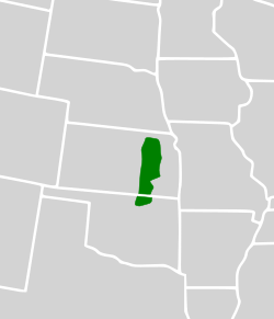
The Flint Hills, historically known as Bluestem Pastures or Blue Stem Hills, [1] are a region of hills and prairies that lie mostly in eastern Kansas. It is named for the abundant residual flint eroded from the bedrock that lies near or at the surface. It consists of a band of hills extending from Marshall and Washington Counties in the north to Cowley County, Kansas and Kay and Osage Counties in Oklahoma in the south, to Geary and Shawnee Counties west to east. [2] Oklahomans generally refer to the same geologic formation as the Osage Hills or "the Osage."

Contents

The Flint Hills Ecoregion is designated as a distinct region because it has the densest coverage of intact tallgrass prairie in North America. Due to its rocky soil, the early settlers were unable to plow the area, resulting in the prevalence of cattle ranches as opposed to the crop land more typical of the Great Plains. These ranches rely on annual controlled burns conducted by ranchers every spring to renew the prairie grasses for cattle to graze.

The Flint Hills Discovery Center, a science and history museum focusing on the Flint Hills, opened in Manhattan, Kansas, in April 2012.

Description

Konza Prairie Preserve, a tallgrass prairie in the Flint Hills Konza2.jpg
Konza Prairie Preserve, a tallgrass prairie in the Flint Hills
A walking trail in the Konza Prairie shows the height of the grasses in the fall. Konza Prairie Trail Fall 1.jpg
A walking trail in the Konza Prairie shows the height of the grasses in the fall.

Explorer Zebulon Pike first coined the name the Flint Hills in 1806 when he entered into his journal, "passed very ruff flint hills". The underlying bedrock of the hills is a flinty limestone. The largest town in the area is Manhattan, Kansas, and the hills can be accessed from the Flint Hills Scenic Byway, which passes through the region.

Geology

The rocks exposed in the Flint Hills were laid down about 250 million years ago during the Permian Period. During this time, much of the Midwest, including Kansas and Oklahoma, was covered with shallow seas. As a result, much of the Flint Hills is composed of limestone and shale, with plentiful fossils of prehistoric sea creatures. The most notable layer of chert-bearing limestone is the Florence Limestone Member, which is approximately 45-foot thick (14 m). Numerous roadcuts of the Florence Member are prominent along Interstate 70 in Riley County, Kansas. Unlike the Pennsylvanian limestones to the east, however, many of the limestones in the Flint Hills contain several bands of chert or flint. Because chert is much less soluble than the limestone surrounding it, the weathering of the limestone has left behind a clay soil with abundant chert gravel. Most of the hilltops in the region are capped with this chert gravel.

The highest point in the Flint Hills is Butler County High Point, with an elevation of 1680 ft (512 m). [3]

Environment

Due to shallow outcroppings of limestone and chert that lay just underneath the soil surface, corn and wheat farming were not practical over much of the area since plowing the land wasn't feasible. For this reason, cattle ranching became the main agricultural activity in the region.

Never having been ploughed over and sparsely developed, the Flint Hills represent the last expanse of intact tallgrass prairie in the nation. [4] They present the best opportunity for sustained preservation of this unique habitat that once covered the vast Great Plains. Most of the plains, such as the Central tall grasslands to the north, have better soil than the Flint Hills and a richer plant cover, but have almost entirely been converted to farmland. [2]

Landscape of Flint Hills Flint Hills - 51424666164.jpg
Landscape of Flint Hills

Tallgrass prairie is renewed by fire and grazing, which also keeps back the growth of trees and shrubs. Prominent grass species are big bluestem (Andropogon gerardi), switchgrass (Panicum virgatum), and Indian grass (Sorghastrum nutans).

Animals native to the Flint Hills include the American bison, which once grazed the area by the millions and were almost entirely exterminated, but have now been reintroduced. The elk that once roamed the region are gone.

The United States Environmental Protection Agency and the World Wildlife Fund have designated the Flint Hills as an ecoregion, distinct from other grasslands of the Great Plains. [5] [6]

Four tallgrass prairie preserves are located in the Flint Hills. The largest of these, the Tallgrass Prairie Preserve, in the Osage Hills near Pawhuska, Oklahoma boasts a large population of bison and is an important refuge for other wildlife such as the greater prairie chicken (Tympanuchus cupido). The other preserves in Kansas, are the 17-square-mile (44 km2) Tallgrass Prairie National Preserve in northern Chase County near Strong City, [7] [8] the Flint Hills Tallgrass Prairie Preserve east of Cassoday, "the Prairie Chicken Capital of the World", [9] and the Konza Prairie, which is managed as a tallgrass prairie biological research station by Kansas State University and is located near Manhattan.

See also

Related Research Articles

<span class="mw-page-title-main">Prairie</span> Ecosystems considered part of the temperate grasslands, savannas, and shrublands biome

Prairies are ecosystems considered part of the temperate grasslands, savannas, and shrublands biome by ecologists, based on similar temperate climates, moderate rainfall, and a composition of grasses, herbs, and shrubs, rather than trees, as the dominant vegetation type. Temperate grassland regions include the Pampas of Argentina, Brazil and Uruguay, and the steppe of Ukraine, Russia and Kazakhstan. Lands typically referred to as "prairie" tend to be in North America. The term encompasses the area referred to as the Interior Lowlands of Canada, the United States, and Mexico, which includes all of the Great Plains as well as the wetter, hillier land to the east.

<span class="mw-page-title-main">Tallgrass Prairie National Preserve</span> In the Flint Hills region of Kansas, US

Tallgrass Prairie National Preserve is a United States National Preserve located in the Flint Hills region of Kansas, north of Strong City. The preserve protects a nationally significant example of the once vast tallgrass prairie ecosystem. Of the 400,000 square miles (1,000,000 km2) of tallgrass prairie that once covered the North American continent, less than 5% remains, primarily in the Flint Hills. Since 2009, the preserve has been home to the Tallgrass Prairie bison herd.

<span class="mw-page-title-main">Tallgrass prairie</span> Ecosystem native to central North America

The tallgrass prairie is an ecosystem native to central North America. Historically, natural and anthropogenic fire, as well as grazing by large mammals provided periodic disturbances to these ecosystems, limiting the encroachment of trees, recycling soil nutrients, and facilitating seed dispersal and germination. Prior to widespread use of the steel plow, which enabled large scale conversion to agricultural land use, tallgrass prairies extended throughout the American Midwest and smaller portions of southern central Canada, from the transitional ecotones out of eastern North American forests, west to a climatic threshold based on precipitation and soils, to the southern reaches of the Flint Hills in Oklahoma, to a transition into forest in Manitoba.

<span class="mw-page-title-main">Sandhills (Nebraska)</span> Temperate grasslands, savannas, and shrublands ecoregion of Nebraska, United States

The Sandhills, often written Sand Hills, is a region of mixed-grass prairie on grass-stabilized sand dunes in north-central Nebraska, covering just over one quarter of the state. The dunes were designated a National Natural Landmark in 1984.

<span class="mw-page-title-main">Texas Blackland Prairies</span> Temperate grassland region of Texas, US

The Texas Blackland Prairies are a temperate grassland ecoregion located in Texas that runs roughly 300 miles (480 km) from the Red River in North Texas to San Antonio in the south. The prairie was named after its rich, dark soil. Less than 1% of the original Blackland prairie vegetation remains, scattered across Texas in parcels.

<span class="mw-page-title-main">Tallgrass Prairie Preserve</span> Largest tract of remaining tallgrass prairie in the world

The Joseph H. Williams Tallgrass Prairie Preserve, in Osage County, Oklahoma near Foraker, Oklahoma, is the largest protected tract of tallgrass prairie in the world. Managed by The Nature Conservancy, the preserve contains 39,650 acres (160 km2) owned by the Conservancy and another 6,000 acres (24 km2) leased in what was the original tallgrass region of the Great Plains that stretched from Texas to Manitoba.

<span class="mw-page-title-main">Western Gulf coastal grasslands</span> Subtropical grassland ecoregion of Mexico and the United States

The Western Gulf coastal grasslands are a subtropical grassland ecoregion of the southern United States and northeastern Mexico. It is known in Louisiana as the "Cajun Prairie", Texas as "Coastal Prairie," and as the Tamaulipan pastizal in Mexico.

<span class="mw-page-title-main">Osage Plains</span> Physiographic section extending through five U.S. states

The Osage Plains are a physiographic section of the larger Central Lowland province, which in turn is part of the larger Interior Plains physiographic division. The area is sometimes called the Lower Plains, North Central Plains,or Rolling Plains. The Osage Plains, covering west-central Missouri, the southeastern third of Kansas, most of central Oklahoma, and extending into north-central Texas, is the southernmost of three tallgrass prairie physiographic areas. It grades into savanna and woodland to the east and south, and into shorter, mixed-grass prairie to the west. The Osage Plains consist of three subregions. The Osage Plains proper occupy the northeast segment. Although sharply demarcated from the Ozark uplift, the plains are nonetheless a transitional area across which the boundary between prairie and woodland has shifted over time. In the central portion of the physiographic area lies the second subregion, the Flint Hills, commonly called "the Osage" in Oklahoma. This large remnant core of native tallgrass prairie is a rocky rolling terrain that runs from north to south across Kansas and extends into Oklahoma. To the west and south of these hills are the Blackland Prairies and Cross Timbers. This vegetatively complex region of intermixed prairie and scrubby juniper-mesquite woodland extends into north-central Texas. Bluestem prairies and oak-dominated savannas and woodlands characterize the natural vegetation in the Cross Timbers. Much of the area has been converted to agriculture, although expanses of oak forest and woodland are still scattered throughout the eastern portion of the subregion.

<span class="mw-page-title-main">Konza Prairie Biological Station</span>

The Konza Prairie Biological Station is a 8,616-acre (3,487 ha) protected area of native tallgrass prairie in the Flint Hills of northeastern Kansas. "Konza" is an alternative name for the Kansa or Kaw Indians who inhabited this area until the mid-19th century. The Konza Prairie is owned by The Nature Conservancy and Kansas State University.

<span class="mw-page-title-main">Goose Lake Prairie State Natural Area</span> State park in Illinois, USA

Goose Lake Prairie State Natural Area is a 2,537-acre (1,027 ha) state park and listed state nature preserve. More than half of the state park is a tallgrass prairie maintained as a natural area of Illinois. It is located in Grundy County near the town of Morris approximately 50 miles (80 km) southwest of Chicago.

<span class="mw-page-title-main">Shortgrass prairie</span> Ecosystem located on the North American Great Plains

The shortgrass prairie is an ecosystem located in the Great Plains of North America. The two most dominant grasses in the shortgrass prairie are blue grama and buffalograss, the two less dominant grasses in the prairie are greasegrass and sideoats grama. The prairie was formerly maintained by grazing pressure of American bison, which is the keystone species. Due to its semiarid climate, the shortgrass prairie receives on average less precipitation than that of the tall and mixed grass prairies to the east.

The North America Prairies is a large grassland floristic province within the North American Atlantic Region, a floristic region within the Holarctic Kingdom. It lies between the Appalachian Province and the Rocky Mountains and includes the prairies of the Great Plains. It is bounded by the Canadian coniferous forests on the north and the arid semideserts to the southwest. The province itself is occupied by temperate grasslands, savannas, and shrublands. Endemism is rather limited in this province, and its boundaries are vague. During the Pleistocene much of the province was glaciated.

<span class="mw-page-title-main">Ozark Highlands (ecoregion)</span>

The Ozark Highlands is a Level III ecoregion designated by the Environmental Protection Agency (EPA) in four U.S. states. Most of the region is within Missouri, with a part in Arkansas and small sections in Oklahoma and Kansas. It is the largest subdivision of the region known as the Ozark Mountains, less rugged in comparison to the Boston Mountains in Arkansas, the highest part of the Ozarks.

<span class="mw-page-title-main">Manitoba Tall Grass Prairie Preserve</span> Conservation area in Manitoba, Canada

The Manitoba Tall Grass Prairie Preserve is located in southeastern Manitoba near Gardenton and Vita, this is about 50 kilometres (31 mi) south of Steinbach, Manitoba. It is one of the last remaining stands of tallgrass prairie in Manitoba and is part of the Tallgrass Aspen Parkland conservation area in Manitoba and Minnesota. Several groups and organizations help in land preservation in the Manitoba Tall Grass Prairie such as the Nature Conservancy of Canada, Nature Manitoba, Environment Canada, Manitoba Conservation and the Manitoba Habitat Heritage Corporation.

<span class="mw-page-title-main">East Central Texas forests</span> Temperate broadleaf and mixed forests ecoregion of Oklahoma and Texas, United States

The East Central Texas forests or East Central Texas Plains (33) is a small temperate broadleaf and mixed forests ecoregion almost entirely within the state of Texas, United States. The northern forests perimeter is partially within the southeast Oklahoma border.

<span class="mw-page-title-main">Central forest–grasslands transition</span> Temperate grasslands, savannas, and shrublands ecoregion of the United States

The central forest–grasslands transition is a prairie ecoregion of the central United States, an ecotone between eastern forests and the North American Great Plains. It is a classification defined by the World Wildlife Fund.

<span class="mw-page-title-main">Central tall grasslands</span> Temperate grasslands, savannas, and shrublands ecoregion of the United States

The Central tall grasslands are a prairie ecoregion of the Midwestern United States, part of the North American Great Plains.

The ecology of the Great Plains is diverse, largely owing to their great size. Differences in rainfall, elevation, and latitude create a variety of habitats including short grass, mixed grass, and tall-grass prairies, and riparian ecosystems.

<span class="mw-page-title-main">Central Great Plains (ecoregion)</span> Temperate grasslands, savannas, and shrublands ecoregion of the United States

The Central Great Plains are a semiarid prairie ecoregion of the central United States, part of North American Great Plains. The region runs from west-central Texas through west-central Oklahoma, central Kansas, and south-central Nebraska.

References

  1. U.S. Geological Survey Geographic Names Information System: Flint Hills
  2. 1 2 Klinkenborg, Verlyn (April 2007). "Splendor of the Grass: The Prairie's Grip is Unbroken in the Flint Hills of Kansas". National Geographic. Archived from the original on February 26, 2018. Retrieved March 27, 2007.
  3. "Flint Hills". Peakbagger.com. November 1, 2004. Retrieved July 24, 2014.
  4. Berger, Joel; Beckmann, Jon (February 19, 2020). "Animals large and small once covered North America's prairies – and in some places, they could again". The Conversation. Retrieved December 16, 2020.
  5. "Ecoregion Maps and GIS Resources". United States Environmental Protection Agency . Retrieved April 10, 2008.
  6. "Flint Hills tall grasslands". Terrestrial Ecoregions. World Wildlife Fund. Retrieved April 17, 2007.
  7. "Tallgrass Prairie National Preserve". U.S. National Park Service. July 7, 2014. Retrieved July 24, 2014.
  8. "Kansas Nature Conservation, Environment Issues". The Nature Conservancy. April 11, 2014. Archived from the original on May 1, 2010. Retrieved July 24, 2014.
  9. "Kansas Nature Conservation, Environment Issues | The Nature Conservancy". Nature.org. April 11, 2014. Archived from the original on February 9, 2009. Retrieved July 24, 2014.
  10. Mathematics StackExchange Flint Hills series
  11. "On convergence of the Flint Hills series" by Max A. Alekseyev Alekseyev, Max A. (2011), On convergence of the Flint Hills series, arXiv: 1104.5100
Maps
Photos