Economic geography is the subfield of human geography that studies economic activity and factors affecting it. It can also be considered a subfield or method in economics.

In general, a rural area or a countryside is a geographic area that is located outside towns and cities. Typical rural areas have a low population density and small settlements. Agricultural areas and areas with forestry are typically described as rural, as well as other areas lacking substantial development. Different countries have varying definitions of rural for statistical and administrative purposes.
One of the major subfields of urban economics, economies of agglomeration, explains, in broad terms, how urban agglomeration occurs in locations where cost savings can naturally arise. This term is most often discussed in terms of economic firm productivity. However, agglomeration effects also explain some social phenomena, such as large proportions of the population being clustered in cities and major urban centers. Similar to economies of scale, the costs and benefits of agglomerating increase the larger the agglomerated urban cluster becomes. Several prominent examples of where agglomeration has brought together firms of a specific industry are: Silicon Valley and Los Angeles being hubs of technology and entertainment, respectively, in California, United States; and London, United Kingdom, being a hub of finance.

Urban sprawl is defined as "the spreading of urban developments on undeveloped land near a more or less densely populated city". Urban sprawl has been described as the unrestricted growth in many urban areas of housing, commercial development, and roads over large expanses of land, with little concern for very dense urban planning. Sometimes the urban areas described as the most "sprawling" are the most densely populated. In addition to describing a special form of urbanization, the term also relates to the social and environmental consequences associated with this development. In modern times some suburban areas described as "sprawl" have less detached housing and higher density than the nearby core city. Medieval suburbs suffered from the loss of protection of city walls, before the advent of industrial warfare. Modern disadvantages and costs include increased travel time, transport costs, pollution, and destruction of the countryside. The revenue for building and maintaining urban infrastructure in these areas are gained mostly through property and sales taxes. Most jobs in the US are now located in suburbs generating much of the revenue, although a lack of growth will require higher tax rates.

An urban area is a human settlement with a high population density and an infrastructure of built environment. This is the core of a metropolitan statistical area in the United States, if it contains a population of more than 50,000.

Central place theory is an urban geographical theory that seeks to explain the number, size and range of market services in a commercial system or human settlements in a residential system. It was introduced in 1933 to explain the spatial distribution of cities across the landscape. The theory was first analyzed by German geographer Walter Christaller, who asserted that settlements simply functioned as 'central places' providing economic services to surrounding areas. Christaller explained that a large number of small settlements will be situated relatively close to one another for efficiency, and because people don't want to travel far for everyday needs, like getting bread from a bakery. But people would travel further for more expensive and infrequent purchases or specialized goods and services which would be located in larger settlements that are farther apart.
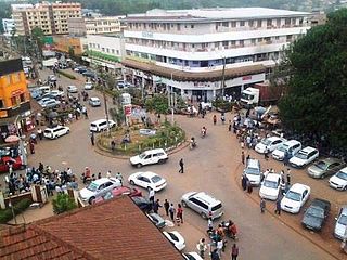
Kisii is a municipality and urban centre in south-western Kenya and the capital city of Kisii County. Kisii Town also serves as a major urban and commercial centre in the Gusii Highlands—Kisii and Nyamira counties—and the South Nyanza region and is the second largest town in formerly greater Nyanza after Kisumu City. Kisii municipality sits right at the centre of the western Kenya tourist circuit that includes the Tabaka Soapstone Carvings, Maasai Mara, Ruma National Park and part of the Lake Victoria Basin.

In geography, statistics and archaeology, a settlement, locality or populated place is a community of people living in a particular place. The complexity of a settlement can range from a minuscule number of dwellings grouped together to the largest of cities with surrounding urbanized areas. Settlements include hamlets, villages, towns and cities. A settlement may have known historical properties such as the date or era in which it was first settled, or first settled by particular people. The process of settlement involves human migration.
A business cluster is a geographic concentration of interconnected businesses, suppliers, and associated institutions in a particular field. Clusters are considered to increase the productivity with which companies can compete, nationally and globally. Accounting is a part of the business cluster. In urban studies, the term agglomeration is used. Clusters are also important aspects of strategic management.

Karnataka is one of the highest economic growth states in India with an expected GSDP growth of 9.5% in the 2021–22 fiscal year. The total expected GSDP of Karnataka in 2022–2023 is about $240 billion. Karnataka recorded the highest growth rates in terms of GDP and per capita GDP in the last decade compared to other states. In 2008–09, the tertiary sector contributed the most to GSDP, followed by the secondary sector, and the primary sector.

Transport geography or transportation geography is a branch of geography that investigates the movement and connections between people, goods and information on the Earth's surface.
Activity centre is a term used in urban planning and design for a mixed-use urban area where there is a concentration of commercial and other land uses. For example, the central business districts of cities (CBD) are also known as “Central Activities Districts” (CAD) (also known as Downtown in North America or "Central Activities Zone" in the United Kingdom, in recognition of the fact that commercial functions are not the only things that occur there. The term activity centre can also be used to designate an area for mixed-use development, whatever its current land use happens to be.
Urban density is a term used in urban planning and urban design to refer to the number of people inhabiting a given urbanized area. As such it is to be distinguished from other measures of population density. Urban density is considered an important factor in understanding how cities function. Research related to urban density occurs across diverse areas, including economics, health, innovation, psychology and geography as well as sustainability.
Spatial inequality refers to the unequal distribution of income and resources across geographical regions. Attributable to local differences in infrastructure, geographical features and economies of agglomeration, such inequality remains central to public policy discussions regarding economic inequality more broadly.
A settlement hierarchy is a way of arranging settlements into a hierarchy based upon their size. The term is used by landscape historians and in the National Curriculum for England. The term is also used in the planning system for the UK and for some other countries such as Ireland, India, and Switzerland. The term was used without comment by the geographer Brian Roberts in 1972.

Urbanization in China increased in speed following the initiation of the reform and opening policy. By the end of 2023, China had an urbanization rate of 66.2% and is expected to reach 75-80% by 2035.

The following outline is provided as an overview of and topical guide to geography:
The following outline is provided as an overview of and topical guide to social science:
Innovation districts are urban geographies of innovation where R&D strong institutions, companies, and other private actors develop integrated strategies and solutions to develop thriving innovation ecosystems–areas that attract entrepreneurs, startups, and business incubators. Unlike science parks, innovation districts are physically compact, leverage density and high levels of accessibility, and provide a “mash up” of activities including housing, office, and neighborhood-serving amenities. Districts signify the collapse back of innovation into cities and is increasingly used as a way to revitalize the economies of cities and their broader regions. As of 2019, there are more than 100 districts worldwide.