Plurality voting refers to electoral systems in which the candidates in an electoral district who poll more than any other are elected.
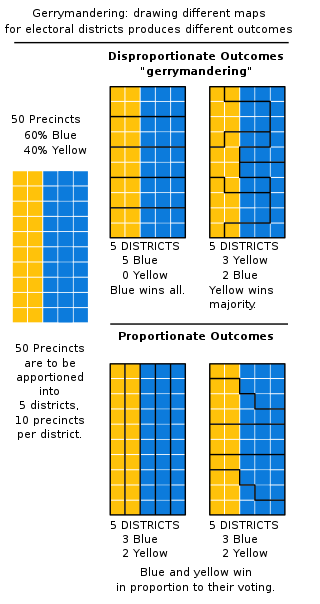
In representative electoral systems, gerrymandering is the political manipulation of electoral district boundaries with the intent to create undue advantage for a party, group, or socioeconomic class within the constituency. The manipulation may involve "cracking" or "packing". Gerrymandering can also be used to protect incumbents. Wayne Dawkins, a professor at Morgan State University, describes it as politicians picking their voters instead of voters picking their politicians.
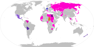
Proportional representation (PR) refers to any type of electoral system under which subgroups of an electorate are reflected proportionately in the elected body. The concept applies mainly to political divisions among voters. The essence of such systems is that all votes cast – or almost all votes cast – contribute to the result and are effectively used to help elect someone. Under other election systems, a bare plurality or a scant majority are all that are used to elect candidates. PR systems provide balanced representation to different factions, reflecting how votes are cast.

In the United States, politics functions within a framework of a constitutional federal republic. The three distinct branches share powers: the U.S. Congress which forms the legislative branch, a bicameral legislative body comprising the House of Representatives and the Senate; the executive branch, which is headed by the president of the United States, who serves as the country's head of state and government; and the judicial branch, composed of the Supreme Court and lower federal courts, and which exercises judicial power.
Single non-transferable vote or SNTV is an electoral system used to elect multiple winners. It is a semi-proportional variant of first-past-the-post voting, applied to multi-member districts where each voter casts just one vote. SNTV generally makes it unlikely that a single party will take all seats in a city, as generally happens with winner-take-all systems. SNTV can be considered a variant of dot voting where each voter has only one point to assign.
Voting refers to the process of choosing officials or policies by casting a ballot, a document used by people to formally express their preferences. Republics and representative democracies are governments where the population chooses representatives by voting.
An electoraldistrict, sometimes called a constituency, riding, or ward, is a subdivision of a larger state created to provide its population with representation in the larger state's legislature. That body, or the state's constitution or a body established for that purpose, determines each district's boundaries and whether each will be represented by a single member or multiple members. Generally, only voters (constituents) who reside within the district are permitted to vote in an election held there. District representatives may be elected by a first-past-the-post system, a proportional representative system, or another voting method. They may be selected by a direct election under universal suffrage, an indirect election, or another form of suffrage.

An electoral district in Canada is a geographical constituency upon which Canada's representative democracy is based. It is officially known in Canadian French as a circonscription but frequently called a comté (county). In Canadian English it is also colloquially and more commonly known as a riding or constituency.
Congressional districts, also known as electoral districts in other nations, are divisions of a larger administrative region that represent the population of a region in the larger congressional body. Countries with congressional districts include the United States, the Philippines, and Japan.
Apportionment is the process by which seats in a legislative body are distributed among administrative divisions, such as states or parties, entitled to representation. This page presents the general principles and issues related to apportionment. The page apportionment by country describes the specific practices used around the world. The page Mathematics of apportionment describes mathematical formulations and properties of apportionment rules.
A single-member district or constituency is an electoral district represented by a single officeholder. It contrasts with a multi-member district, which is represented by multiple officeholders.
There are a number of complications and issues surrounding the application and use of single transferable vote proportional representation that form the basis of discussions between its advocates and detractors.
Electoral districts go by different names depending on the country and the office being elected.
Electoral reform is a change in electoral systems which alters how public desires are expressed in election results.
Electoral boundary delimitation is the drawing of boundaries of electoral precincts and related divisions involved in elections, such as states, counties or other municipalities. It can also be called "redistribution" and is used to prevent unbalance of population across districts. In the United States, it is called redistricting. Unbalanced or discriminatory delimitation is called "gerrymandering." Though there are no internationally agreed processes that guarantee fair delimitation, several organizations, such as the Commonwealth Secretariat, the European Union and the International Foundation for Electoral Systems (IFES) have proposed guidelines for effective delimitation.
Semi-proportional representation characterizes multi-winner electoral systems which allow representation of minorities, but are not intended to reflect the strength of the competing political forces in close proportion to the votes they receive. Semi-proportional voting systems are generally used as a compromise between complex and expensive but more-proportional systems and simple winner-take-all systems. Examples of semi-proportional systems include the single non-transferable vote, limited voting, and parallel voting.
An electoral or voting system is a set of rules used to determine the results of an election. Electoral systems are used in politics to elect governments, while non-political elections may take place in business, non-profit organisations and informal organisations. These rules govern all aspects of the voting process: when elections occur, who is allowed to vote, who can stand as a candidate, how ballots are marked and cast, how the ballots are counted, how votes translate into the election outcome, limits on campaign spending, and other factors that can affect the result. Political electoral systems are defined by constitutions and electoral laws, are typically conducted by election commissions, and can use multiple types of elections for different offices.
A mixed electoral system is one that uses different electoral systems to elect different seats in a legislature. Most often, this involves a winner-take-all component combined with a proportional component. The results of the combination may be mixed-member proportional (MMP), where the overall results of the elections are proportional, or mixed-member majoritarian, in which case the overall results are semi-proportional, retaining disproportionalities from the majoritarian component. Systems that use multiple types of combinations are sometimes called supermixed.

The Italian electoral law of 2017, colloquially known by the nickname Rosatellum after Ettore Rosato, the Democratic Party (PD) leader in the Chamber of Deputies who first proposed the new law, is a parallel voting system, which acts as a mixed electoral system, with 37% of seats allocated using a first-past-the-post electoral system and 63% using a proportional method, with one round of voting. The Chamber and Senate of the Republic did not differ in the way they allocated the proportional seats, both using the largest remainder method of allocating seats.
Apportionment by country describes the practices used in various democratic countries around the world for partitioning seats in the parliament among districts or parties. See apportionment (politics) for the general principles and issues related to apportionment.