Marshall County, Kansas

Last updated

Marshall County
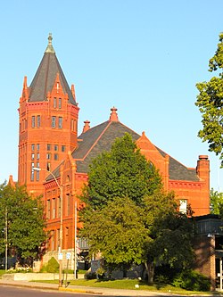
Marshall Co KS Courthouse.JPG
Former Marshall County Courthouse (left), current one-story courthouse (right) in Marysville (2010)
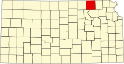
Map of Kansas highlighting Marshall County.svg
Location within the U.S. state of Kansas
Kansas in United States.svg
Kansas's location within the U.S.
Coordinates: 39°48′N96°33′W / 39.800°N 96.550°W / 39.800; -96.550
CountryFlag of the United States.svg United States
StateFlag of Kansas.svg  Kansas
FoundedAugust 25, 1855
Named for Frank J. Marshall
Seat Marysville
Largest cityMarysville
Area
  Total905 sq mi (2,340 km2)
  Land900 sq mi (2,000 km2)
  Water4.9 sq mi (13 km2)  0.20%
Population
 (2020) [1]
  Total10,038
  Estimate 
(2023) [2]
9,933 Decrease2.svg
  Density11.1/sq mi (4.3/km2)
Time zone UTC−6 (Central)
  Summer (DST) UTC−5 (CDT)
Area code 785
Congressional district 1st
Website ks-marshall.manatron.com

Marshall County is a county located in the U.S. state of Kansas. Its county seat and largest city is Marysville. [3] As of the 2020 census, the county population was 10,038. [1] The county was named after Frank J. Marshall, a state representative who operated the first ferry over the Big Blue River.

Contents

History

The Oregon Trail crosses Marshall County. The Infamous Donner Reed Party rested along the banks of the Big Blue river and lost one of its members, Sarah Keyes, who is still buried at Alcove Springs (located outside of Marysville). Many documented pioneer bodies are buried surrounding Alcove Spring.

In 1849 Francis James Marshall, from Weston, Missouri, came to Marshall County and established a ferry service on the Big Blue River at "Independence Crossing." A few years later Francis Marshall decided to stay on in Marshall County and make it his home. He moved his Ferry business to an upper crossing now known as Marysville (the city is named after Marshall's own wife Mary). [4]

On May 30, 1879, the "Irving, Kansas Tornado" passed through Marshall county. This tornado measured F4 on the Fujita scale and had a damage path 800 yards (730 m) wide and 100 miles (160 km) long. Eighteen people were killed and sixty were injured. [5]

The Marshall County Historical Society resides in the county's historic courthouse, which is now a museum and research library.

Geography

According to the U.S. Census Bureau, the county has a total area of 905 square miles (2,340 km2), of which 900 square miles (2,300 km2) is land and 4.9 square miles (13 km2) (0.5%) is water. [6]

Adjacent counties

Demographics

Historical population
CensusPop.Note
1860 74
1870 768937.8%
1880 12,4531,521.5%
1890 20,53964.9%
1900 24,35518.6%
1910 23,880−2.0%
1920 22,730−4.8%
1930 23,0561.4%
1940 20,986−9.0%
1950 17,926−14.6%
1960 15,598−13.0%
1970 13,139−15.8%
1980 12,787−2.7%
1990 11,705−8.5%
2000 10,965−6.3%
2010 10,117−7.7%
2020 10,038−0.8%
2023 (est.)9,933 [7] −1.0%
U.S. Decennial Census [8]
1790-1960 [9] 1900-1990 [10]
1990-2000 [11] 2010-2020 [1]

As of the census [12] of 2000, there were 10,965 people, 4,458 households, and 3,026 families residing in the county. The population density was 12 people per square mile (4.6 people/km2). There were 4,999 housing units at an average density of 6 per square mile (2.3/km2). The racial makeup of the county was 98.14% White, 0.23% Black or African American, 0.36% Native American, 0.19% Asian, 0.02% Pacific Islander, 0.26% from other races, and 0.80% from two or more races. 0.76% of the population were Hispanic or Latino of any race.

There were 4,458 households, out of which 30.20% had children under the age of 18 living with them, 59.70% were married couples living together, 5.40% had a female householder with no husband present, and 32.10% were non-families. 29.50% of all households were made up of individuals, and 17.00% had someone living alone who was 65 years of age or older. The average household size was 2.40 and the average family size was 2.98.

In the county, the population was spread out, with 25.00% under the age of 18, 6.60% from 18 to 24, 23.60% from 25 to 44, 22.80% from 45 to 64, and 22.00% who were 65 years of age or older. The median age was 42 years. For every 100 females there were 96.80 males. For every 100 females age 18 and over, there were 94.00 males.

The median income for a household in the county was $32,089, and the median income for a family was $39,705. Males had a median income of $28,361 versus $19,006 for females. The per capita income for the county was $17,090. About 6.40% of families and 9.20% of the population were below the poverty line, including 9.60% of those under age 18 and 9.10% of those age 65 or over.

Government

Presidential elections

Marshall County is a strongly Republican county. The county has not been carried by a Democratic candidate in a presidential election since 1932, & has only failed to back the Republican candidate in two other elections from 1888 on. The closest Democrats have came to winning the county since 1932 was in 1964 when Barry Goldwater only won it by 98 votes in the midst of a national landslide by Lyndon B. Johnson & 1992 when George H. W. Bush only won it by eight votes in conjunction with independent candidate Ross Perot winning a significant share of the vote.

Presidential election results
United States presidential election results for Marshall County, Kansas [13]
Year Republican Democratic Third party(ies)
No.%No.%No.%
2020 3,72972.92%1,25924.62%1262.46%
2016 3,30770.77%1,07222.94%2946.29%
2012 3,19566.94%1,46930.78%1092.28%
2008 3,15762.69%1,78435.42%951.89%
2004 3,26163.84%1,78935.02%581.14%
2000 3,06659.94%1,83135.80%2184.26%
1996 2,81151.11%1,93235.13%75713.76%
1992 2,03034.65%2,02234.52%1,80630.83%
1988 3,14054.23%2,56044.21%901.55%
1984 4,09868.49%1,81330.30%721.20%
1980 4,12767.69%1,55525.50%4156.81%
1976 6,18752.17%5,36645.24%3072.59%
1972 4,12767.68%1,82329.90%1482.43%
1968 3,83558.85%1,94929.91%73311.25%
1964 3,43250.31%3,33448.87%560.82%
1960 4,93262.50%2,93137.14%280.35%
1956 5,66469.25%2,48730.41%280.34%
1952 6,85175.35%2,21524.36%260.29%
1948 5,12261.50%3,14837.80%590.71%
1944 6,18469.59%2,68130.17%210.24%
1940 7,28666.65%3,58832.82%570.52%
1936 5,92952.98%5,23846.81%240.21%
1932 4,45542.25%5,97056.62%1191.13%
1928 6,91867.06%3,32932.27%690.67%
1924 5,80962.35%2,36925.43%1,13912.22%
1920 5,70671.47%2,02625.38%2523.16%
1916 4,58150.08%4,27546.74%2913.18%
1912 1,49226.98%2,27841.20%1,75931.81%
1908 3,29655.91%2,51442.65%851.44%
1904 3,53066.14%1,56429.30%2434.55%
1900 3,41355.63%2,66943.50%530.86%
1896 3,05251.75%2,77647.07%701.19%
1892 2,53145.32%00.00%3,05454.68%
1888 2,54748.33%1,81534.44%90817.23%

Laws

Marshall County was a prohibition, or "dry", county until the Kansas Constitution was amended in 1986 and voters approved the sale of alcoholic liquor by the individual drink with a 30 percent food sales requirement. [14]

Education

Unified school districts

Historical

Communities

2005 map of Marshall County (map legend) Map of Marshall Co, Ks, USA.png
2005 map of Marshall County (map legend)

List of townships / incorporated cities / unincorporated communities / extinct former communities within Marshall County. [16]

Cities

Unincorporated communities

† means a community is designated a Census-Designated Place (CDP) by the United States Census Bureau.

Ghost towns

Townships

Marshall County is divided into twenty-five townships. The city of Marysville is considered governmentally independent and is excluded from the census figures for the townships. In the following table, the population center is the largest city (or cities) included in that township's population total, if it is of a significant size.

Sources: 2000 U.S. Gazetteer from the U.S. Census Bureau.
Township FIPS Population
center
PopulationPopulation
density
/km2 (/sq mi)
Land area
km2 (sq mi)
Water area
km2 (sq mi)
Water %Geographic coordinates
Balderson038501061 (3)98 (38)0 (0)0.09% 39°57′39″N96°30′39″W / 39.96083°N 96.51083°W / 39.96083; -96.51083
Bigelow06725661 (2)97 (37)1 (0)0.96% 39°36′36″N96°31′56″W / 39.61000°N 96.53222°W / 39.61000; -96.53222
Blue Rapids07675 Blue Rapids 781 (2)93 (36)0 (0)0.23% 39°37′17″N96°37′28″W / 39.62139°N 96.62444°W / 39.62139; -96.62444
Blue Rapids City07700 Irving 1,20113 (34)92 (36)1 (0)0.98% 39°41′6″N96°39′19″W / 39.68500°N 96.65528°W / 39.68500; -96.65528
Center11850 Reedsville 1512 (4)98 (38)0 (0)0% 39°47′14″N96°30′51″W / 39.78722°N 96.51417°W / 39.78722; -96.51417
Clear Fork13875 Bigelow 541 (2)93 (36)0 (0)0.02% 39°36′58″N96°23′55″W / 39.61611°N 96.39861°W / 39.61611; -96.39861
Cleveland14100911 (3)92 (36)1 (0)1.02% 39°36′43″N96°17′47″W / 39.61194°N 96.29639°W / 39.61194; -96.29639
Cottage Hill15850 Cottage Hill 1432 (4)93 (36)0 (0)0.03% 39°36′10″N96°45′34″W / 39.60278°N 96.75944°W / 39.60278; -96.75944
Elm Creek20600 Schroyer 1782 (5)93 (36)0 (0)0.02% 39°46′57″N96°37′52″W / 39.78250°N 96.63111°W / 39.78250; -96.63111
Franklin24450 Home City 3373 (9)98 (38)0 (0)0.06% 39°51′47″N96°31′46″W / 39.86306°N 96.52944°W / 39.86306; -96.52944
Guittard29225 Beattie 4545 (13)93 (36)0 (0)0.03% 39°51′52″N96°24′53″W / 39.86444°N 96.41472°W / 39.86444; -96.41472
Herkimer314502343 (7)92 (36)0 (0)0.02% 39°57′44″N96°45′2″W / 39.96222°N 96.75056°W / 39.96222; -96.75056
Lincoln408501301 (4)92 (35)0 (0)0.36% 39°46′56″N96°17′27″W / 39.78222°N 96.29083°W / 39.78222; -96.29083
Logan41975 Bremen, Herkimer 3354 (9)93 (36)0 (0)0% 39°53′14″N96°45′8″W / 39.88722°N 96.75222°W / 39.88722; -96.75222
Marysville45075 Marysville 3835 (12)84 (32)0 (0)0% 39°51′36″N96°38′42″W / 39.86000°N 96.64500°W / 39.86000; -96.64500
Murray49275 Axtell 6407 (18)92 (36)0 (0)0.14% 39°52′28″N96°16′17″W / 39.87444°N 96.27139°W / 39.87444; -96.27139
Noble50850 Vermillion, Vliets 2172 (6)92 (35)1 (0)0.83% 39°42′45″N96°17′6″W / 39.71250°N 96.28500°W / 39.71250; -96.28500
Oketo52550 Marietta, Oketo 2513 (7)92 (35)0 (0)0% 39°57′11″N96°37′32″W / 39.95306°N 96.62556°W / 39.95306; -96.62556
Richland59450 Summerfield 2062 (6)93 (36)0 (0)0% 39°57′54″N96°23′55″W / 39.96500°N 96.39861°W / 39.96500; -96.39861
Rock 604251231 (3)93 (36)0 (0)0.09% 39°47′2″N96°24′45″W / 39.78389°N 96.41250°W / 39.78389; -96.41250
St. Bridget62100 Mina 2323 (7)92 (35)0 (0)0.05% 39°57′53″N96°19′28″W / 39.96472°N 96.32444°W / 39.96472; -96.32444
Vermillion73550 Barrett, Frankfort 1,01211 (28)93 (36)0 (0)0.07% 39°42′12″N96°24′48″W / 39.70333°N 96.41333°W / 39.70333; -96.41333
Walnut750251442 (4)93 (36)0 (0)0% 39°47′28″N96°44′45″W / 39.79111°N 96.74583°W / 39.79111; -96.74583
Waterville75975 Waterville 7979 (22)93 (36)0 (0)0.03% 39°41′44″N96°45′8″W / 39.69556°N 96.75222°W / 39.69556; -96.75222
Wells 765251311 (3)98 (38)0 (0)0% 39°41′13″N96°30′39″W / 39.68694°N 96.51083°W / 39.68694; -96.51083

[17]

Notable people

See also

The Irving stone marker southeast of Blue Rapids. Irving Marker.JPG
The Irving stone marker southeast of Blue Rapids.
Community information for Kansas

Related Research Articles

<span class="mw-page-title-main">Wilson County, Kansas</span> County in Kansas, United States

Wilson County is a county located in Southeast Kansas. Its county seat is Fredonia. As of the 2020 census, the county population was 8,624. The county was named after Hiero Wilson, a colonel in the American Civil War.

<span class="mw-page-title-main">Washington County, Kansas</span> County in Kansas, United States

Washington County is a county located in the U.S. state of Kansas. Its county seat and largest city is Washington. As of the 2020 census, the county population was 5,530. The county was named for George Washington, the 1st president of the United States.

<span class="mw-page-title-main">Sumner County, Kansas</span> County in Kansas, United States

Sumner County is a county located in the U.S. state of Kansas. Its county seat is Wellington. As of the 2020 census, the population was 22,382. The county is named after Charles Sumner, a U.S. Senator from Massachusetts who was a leader of Reconstruction politics.

<span class="mw-page-title-main">Riley County, Kansas</span> County in Kansas, United States

Riley County is a county located in the U.S. state of Kansas. Its county seat and largest city is Manhattan. As of the 2020 census, the population was 71,959. The county was named after Bennet Riley, the 7th governor of California, and a Mexican–American War hero. Riley County is home to Fort Riley and Kansas State University.

<span class="mw-page-title-main">Pottawatomie County, Kansas</span> County in Kansas, United States

Pottawatomie County is a county located in the U.S. state of Kansas. Its county seat is Westmoreland. As of the 2020 census, the county population was 25,348. The county was named for the Potawatomi tribe.

<span class="mw-page-title-main">Ness County, Kansas</span> County in Kansas, United States

Ness County is a county located in the U.S. state of Kansas. Its county seat and largest city is Ness City. As of the 2020 census, the county population was 2,687. The county was named for Noah Ness, a corporal of the 7th Kansas Cavalry.

<span class="mw-page-title-main">Neosho County, Kansas</span> County in Kansas, United States

Neosho County is a county located in Southeast Kansas. Its county seat is Erie. As of the 2020 census, the county population was 15,904. The county was named for the Neosho River, which passes through the county.

<span class="mw-page-title-main">Nemaha County, Kansas</span> County in Kansas, United States

Nemaha County is a county located in the northeastern part of the U.S. state of Kansas. Its county seat is Seneca. As of the 2020 census, the county population was 10,273. The county was named for the Nemaha River.

<span class="mw-page-title-main">Leavenworth County, Kansas</span> County in Kansas, United States

Leavenworth County is a county located in the U.S. state of Kansas and is part of the Kansas City metropolitan area. Its county seat and most populous city is Leavenworth. As of the 2020 census, the county population was 81,881. The county was named after Henry Leavenworth, a general in the Indian Wars who established Fort Leavenworth.

<span class="mw-page-title-main">Lane County, Kansas</span> County in Kansas, United States

Lane County is a county located in the U.S. state of Kansas. Its county seat is Dighton, the only incorporated city in the county. As of the 2020 census, the county population was 1,574, making it the third-least populous county in Kansas. The county was named after James Lane, a leader of the Jayhawker abolitionist movement and served as one of the first U.S. senators from Kansas.

<span class="mw-page-title-main">Labette County, Kansas</span> County in Kansas, United States

Labette County is a county located in Southeast Kansas. Its county seat is Oswego, and its most populous city is Parsons. As of the 2020 census, the county population was 20,184. The county was named after LaBette creek, the second-largest creek in the county, which runs roughly NNW-SSE from near Parsons to Chetopa. The creek in turn was named after French-Canadian fur trapper Pierre LaBette who had moved to the area, living along the Neosho River, and marrying into the Osage tribe in the 1830s and 1840s.

<span class="mw-page-title-main">Kiowa County, Kansas</span> County in Kansas, United States

Kiowa County is a county located in the U.S. state of Kansas. Its county seat and largest city is Greensburg. As of the 2020 census, the county population was 2,460. The county is named after the Kiowa tribe.

<span class="mw-page-title-main">Jackson County, Kansas</span> County in Kansas, United States

Jackson County is a county in the U.S. state of Kansas. Its county seat and most populous city is Holton. As of the 2020 census, the county population was 13,232. The county, first named Calhoun County for pro-slavery South Carolina Senator John C. Calhoun, was renamed in 1859 for President Andrew Jackson. The Prairie Band Potawatomi Indian Reservation, near the center of the county, comprises about 18.5% of the county's area.

<span class="mw-page-title-main">Harvey County, Kansas</span> County in Kansas, United States

Harvey County is a county located in the U.S. state of Kansas. Its county seat and most populous city is Newton. As of the 2020 census, the county population was 34,024. The county was named for James Harvey, a U.S. senator and 5th governor of Kansas.

<span class="mw-page-title-main">Greenwood County, Kansas</span> County in Kansas, United States

Greenwood County is a county located in the southeast portion of the U.S. state of Kansas. Its county seat and most populous city is Eureka. As of the 2020 census, the county population was 6,016. The county was named for Alfred Greenwood, a U.S. congressman from Arkansas that advocated Kansas statehood.

<span class="mw-page-title-main">Gray County, Kansas</span> County in Kansas, United States

Gray County is a county located in the U.S. state of Kansas. Its county seat and most populous city is Cimarron. As of the 2020 census, the county population was 5,653. The county was named after Alfred Gray, a 19th century Kansas politician.

<span class="mw-page-title-main">Coffey County, Kansas</span> County in Kansas, United States

Coffey County is a county located in Eastern Kansas. Its county seat and most populous city is Burlington. As of the 2020 census, the county population was 8,360. It was named after A.M. Coffey, a territorial legislator and Free-Stater during Bleeding Kansas era.

<span class="mw-page-title-main">Cherokee County, Kansas</span> County in Kansas, United States

Cherokee County is a U.S. county located in Southeast Kansas. Its county seat is Columbus, and its most populous city is Baxter Springs. As of the 2020 census, the county population was 19,362. The county was named for the Cherokee tribe.

<span class="mw-page-title-main">Brown County, Kansas</span> County in Kansas, United States

Brown County is a county located in the northeast portion of the U.S. state of Kansas. Its county seat and most populous city is Hiawatha. As of the 2020 census, the county population was 9,508. The county was named after Albert G. Brown, a U.S. Senator from Mississippi and Kansas statehood advocate. The Kickapoo Indian Reservation of Kansas, the majority of the Sac and Fox Reservation, and the majority of the Iowa Reservation of Kansas and Nebraska are located within the county.

<span class="mw-page-title-main">Anderson County, Kansas</span> County in Kansas, United States

Anderson County is a county located in East Central Kansas, in the Central United States. Its county seat and most populous city is Garnett. As of the 2020 census, the county population was 7,836. The county was named for Joseph C. Anderson, a Kansas territorial legislator and border ruffian during the "Bleeding Kansas" era.

References

  1. 1 2 3 "QuickFacts; Marshall County, Kansas; Population, Census, 2020 & 2010". United States Census Bureau. Archived from the original on August 18, 2021. Retrieved August 17, 2021.
  2. "Annual Estimates of the Resident Population for Counties: April 1, 2020 to July 1, 2023". United States Census Bureau. Retrieved March 24, 2024.
  3. "Find a County". National Association of Counties. Retrieved June 7, 2011.
  4. History of Kansas Vol. 2 By Andreas
  5. John Albert Sleicher (1883). Leslie's. F. Leslie.
  6. "US Gazetteer files: 2010, 2000, and 1990". United States Census Bureau. February 12, 2011. Retrieved April 23, 2011.
  7. "Annual Estimates of the Resident Population for Counties: April 1, 2020 to July 1, 2023". United States Census Bureau. Retrieved April 3, 2024.
  8. "U.S. Decennial Census". United States Census Bureau. Retrieved July 27, 2014.
  9. "Historical Census Browser". University of Virginia Library. Retrieved July 27, 2014.
  10. "Population of Counties by Decennial Census: 1900 to 1990". United States Census Bureau. Retrieved July 27, 2014.
  11. "Census 2000 PHC-T-4. Ranking Tables for Counties: 1990 and 2000" (PDF). United States Census Bureau. Archived (PDF) from the original on March 27, 2010. Retrieved July 27, 2014.
  12. "U.S. Census website". United States Census Bureau . Retrieved January 31, 2008.
  13. "Dave Leip's Atlas of U.S. Presidential Elections".
  14. "Map of Wet and Dry Counties". Alcoholic Beverage Control, Kansas Department of Revenue. November 2006. Archived from the original on October 8, 2007. Retrieved December 28, 2007.
  15. School consolidations in Kansas for past decade; Topeka-Capital Journal; July 24, 2011.
  16. 1 2 "General Highway Map of Marshall County, Kansas" (PDF). Kansas Department of Transportation (KDOT). December 2011. Archived (PDF) from the original on May 19, 2024.
  17. "Plat book of Marshall County, Kansas" 1904. https://www.kansasmemory.org/item/209410

Further reading

County
Historical
Tornados
Maps