Kearny County, Kansas

Last updated

Kearny County
Kearny County, Kansas courthouse from SE 1.JPG
Kearny County Courthouse in Lakin (2015)
Map of Kansas highlighting Kearny County.svg
Location within the U.S. state of Kansas
Kansas in United States.svg
Kansas's location within the U.S.
Coordinates: 38°00′29″N101°08′54″W / 38.0081°N 101.1483°W / 38.0081; -101.1483
CountryFlag of the United States.svg United States
StateFlag of Kansas.svg  Kansas
FoundedMarch 20, 1873
Named for Philip Kearny
Seat Lakin
Largest cityLakin
Area
  Total871 sq mi (2,260 km2)
  Land871 sq mi (2,260 km2)
  Water0.4 sq mi (1 km2)  0.05%
Population
 (2020) [1]
  Total3,983
  Density4.6/sq mi (1.8/km2)
Time zone UTC−6 (Central)
  Summer (DST) UTC−5 (CDT)
Congressional district 1st
Website KearnyCountyKansas.com
1893 map of Kansas showing Kearney County spelled with an extra "e" Base map of Kansas. LOC 2005625111.tif
1893 map of Kansas showing Kearney County spelled with an extra "e"

Kearny County is a county located in the U.S. state of Kansas. Its county seat and most populous city is Lakin. [2] As of the 2020 census, the county population was 3,983. [1] The county is named in honor of Philip Kearny, a general during the American Civil War that died during the Battle of Chantilly.

Contents

History

The original Kearney County was established on March 6, 1873, and was dissolved in 1883, with the land area being split between Hamilton and Finney counties. It was reestablished with its original borders in 1887, and organized on March 27, 1888. The county is named in honor of Philip Kearny, [3] a U.S. Army officer in the Mexican–American War and a Union army general in the American Civil War. In 1889, the name was corrected to Kearny County. [4]

Prior to settlement, Kearny County was unorganized territory that was entirely "cow country," undeveloped and with no agricultural activity except for cattlemen grazing their herds. The region was part of the vast open range found in the American West at that time. [5]

In the mid-1880s, homesteaders began pouring into the area, initiating conflicts with the existing cattle ranching industry as they claimed land and fenced off the open range. [5] [6] Towns like Leeser, established in 1885, and Pierceville, est. 1886, were built to service the cattle industry, but disappeared as homesteading displaced the great cattle herds. [6]

The arrival of homesteaders was seen as both an opportunity for development but also a threat to the cattle industry's way of life, with numerous allegations of ranchers trying to drive settlers out by destroying crops and setting prairie fires appearing in local newspapers. [5]

In the 1930s, the prosperity of the area was severely affected by its location within the Dust Bowl. This catastrophe intensified the economic impact of the Great Depression in the region.

Geography

According to the U.S. Census Bureau, the county has a total area of 871 square miles (2,260 km2), of which 871 square miles (2,260 km2) is land and 0.4 square miles (1.0 km2) (0.05%) is water. [7]

Major highways

Time zones

The west half of Kearny County observed Mountain Standard Time until October 28, 1990, when the Kansas Department of Transportation moved the entire county into the Central Time Zone, which 100 of the state's other 104 counties observe. Only four counties (Hamilton, Greeley, Wallace, and Sherman), all of which border Colorado, observe Mountain Time. [8]

Adjacent counties

Demographics

Population pyramid based on 2000 census age data USA Kearny County, Kansas age pyramid.svg
Population pyramid based on 2000 census age data
Historical population
CensusPop.Note
1880 159
1890 1,571888.1%
1900 1,107−29.5%
1910 3,206189.6%
1920 2,617−18.4%
1930 3,19622.1%
1940 2,525−21.0%
1950 3,49238.3%
1960 3,108−11.0%
1970 3,047−2.0%
1980 3,43512.7%
1990 4,02717.2%
2000 4,53112.5%
2010 3,977−12.2%
2020 3,9830.2%
2023 (est.)3,823 [9] −4.0%
U.S. Decennial Census [10]
1790-1960 [11] 1900-1990 [12]
1990-2000 [13] 2010-2020 [1]

Kearny County is included in the Garden City, KS Micropolitan Statistical Area.

As of the 2000 census, [14] there were 4,531 people, 1,542 households, and 1,199 families residing in the county. The population density was 5 people per square mile (1.9 people/km2). There were 1,657 housing units at an average density of 2 per square mile (0.77/km2). The racial makeup of the county was 80.34% White, 0.55% Black or African American, 0.86% Native American, 0.31% Asian, 0.09% Pacific Islander, 15.71% from other races, and 2.14% from two or more races. Hispanic or Latino of any race were 26.55% of the population.

There were 1,542 households, out of which 43.50% had children under the age of 18 living with them, 65.10% were married couples living together, 8.30% had a female householder with no husband present, and 22.20% were non-families. 20.20% of all households were made up of individuals, and 8.50% had someone living alone who was 65 years of age or older. The average household size was 2.91 and the average family size was 3.35.

In the county, the population was spread out, with 34.30% under the age of 18, 8.30% from 18 to 24, 27.10% from 25 to 44, 19.20% from 45 to 64, and 11.10% who were 65 years of age or older. The median age was 32 years. For every 100 females there were 104.70 males. For every 100 females age 18 and over, there were 98.50 males.

The median income for a household in the county was $40,149, and the median income for a family was $43,703. Males had a median income of $30,117 versus $20,179 for females. The per capita income for the county was $15,708. About 8.40% of families and 11.70% of the population were below the poverty line, including 15.90% of those under age 18 and 4.80% of those age 65 or over.

Government

Presidential elections

Presidential election results
United States presidential election results for Kearny County, Kansas [15]
Year Republican Democratic Third party
No.%No.%No.%
2020 1,16480.00%26718.35%241.65%
2016 1,07581.69%17413.22%675.09%
2012 1,09779.15%26819.34%211.52%
2008 1,15978.21%30920.85%140.94%
2004 1,17780.89%27218.69%60.41%
2000 1,08475.54%32022.30%312.16%
1996 1,04170.05%33522.54%1107.40%
1992 94355.18%38422.47%38222.35%
1988 1,07366.03%52432.25%281.72%
1984 1,21478.42%32120.74%130.84%
1980 92466.38%37526.94%936.68%
1976 67448.95%65847.79%453.27%
1972 87670.87%32526.29%352.83%
1968 72158.00%42334.03%997.96%
1964 56342.81%73756.05%151.14%
1960 84662.11%51337.67%30.22%
1956 85466.98%41832.78%30.24%
1952 1,01272.81%36226.04%161.15%
1948 67654.43%54143.56%252.01%
1944 61262.45%36537.24%30.31%
1940 72158.00%51941.75%30.24%
1936 58644.63%71654.53%110.84%
1932 52938.93%77156.73%594.34%
1928 85477.22%22920.71%232.08%
1924 63557.57%19918.04%26924.39%
1920 61763.74%26627.48%858.78%
1916 53845.29%49041.25%16013.47%
1912 11317.02%23635.54%31547.44%
1908 43556.64%30439.58%293.78%
1904 23470.69%9428.40%30.91%
1900 16453.77%13744.92%41.31%
1896 17249.43%17550.29%10.29%
1892 21960.83%00.00%14139.17%
1888 36759.39%24840.13%30.49%

Laws

Following amendment to the Kansas Constitution in 1986, the county remained a prohibition, or "dry", county until 1988, when voters approved the sale of alcoholic liquor by the individual drink with a 30 percent food sales requirement. [16]

Education

Unified school districts

Communities

2005 map of Kearny County (map legend) Map of Kearny Co, Ks, USA.png
2005 map of Kearny County (map legend)

List of townships / incorporated cities / unincorporated communities / extinct former communities within Kearny County. [17]

Cities

Townships

Area affected by 1930s Dust Bowl Map of states and counties affected by the Dust Bowl, sourced from US federal government dept. (NRCS SSRA-RAD).svg
Area affected by 1930s Dust Bowl

Kearny County is divided into seven townships. None of the cities within the county are considered governmentally independent, and all figures for the townships include those of the cities. In the following table, the population center is the largest city (or cities) included in that township's population total, if it is of a significant size.

Township FIPS Population
center
PopulationPopulation
density
/km2 (/sq mi)
Land area
km2 (sq mi)
Water area
km2 (sq mi)
Water %Geographic coordinates
Deerfield17250 Deerfield 1,1049 (24)120 (46)1 (0)0.66% 38°0′30″N101°8′55″W / 38.00833°N 101.14861°W / 38.00833; -101.14861
East Hibbard195501310 (1)403 (156)0 (0)0% 38°9′19″N101°12′14″W / 38.15528°N 101.20389°W / 38.15528; -101.20389
Hartland305001280 (1)388 (150)0 (0)0.03% 38°0′44″N101°24′49″W / 38.01222°N 101.41361°W / 38.01222; -101.41361
Kendall364501570 (1)494 (191)0 (0)0% 37°46′56″N101°18′32″W / 37.78222°N 101.30889°W / 37.78222; -101.30889
Lakin38200 Lakin 2,58716 (41)164 (63)0 (0)0.04% 37°57′16″N101°15′45″W / 37.95444°N 101.26250°W / 37.95444; -101.26250
Southside670253591 (3)286 (110)0 (0)0.06% 37°55′9″N101°12′12″W / 37.91917°N 101.20333°W / 37.91917; -101.20333
West Hibbard77050650 (0)402 (155)0 (0)0% 38°10′10″N101°25′23″W / 38.16944°N 101.42306°W / 38.16944; -101.42306
Sources: "Census 2000 U.S. Gazetteer Files". U.S. Census Bureau, Geography Division. Archived from the original on August 2, 2002.

See also

Community information for Kansas

Related Research Articles

<span class="mw-page-title-main">Wichita County, Kansas</span> County in Kansas, United States

Wichita County is a county located in the U.S. state of Kansas. Its county seat is Leoti. As of the 2020 census, the county population was 2,152. The county was named after the Wichita tribe.

<span class="mw-page-title-main">Trego County, Kansas</span> County in Kansas, United States

Trego County is a county located in the U.S. state of Kansas. Its county seat and largest city is WaKeeney. As of the 2020 census, the county population was 2,808. The county was named for Edgar Trego.

<span class="mw-page-title-main">Thomas County, Kansas</span> County in Kansas, United States

Thomas County is a county located in the U.S. state of Kansas. Its county seat is Colby. As of the 2020 census, the county population was 7,930. The county was named after George Thomas, a general during the American Civil War.

<span class="mw-page-title-main">Stanton County, Kansas</span> County in Kansas, United States

Stanton County is a county located in the U.S. state of Kansas. Its county seat is Johnson City. As of the 2020 census, the county population was 2,084. It was named for Edwin Stanton, the U.S. Secretary of War during most of the American Civil War.

<span class="mw-page-title-main">Sherman County, Kansas</span> County in Kansas, United States

Sherman County is a county located in the U.S. state of Kansas. Its county seat is Goodland. As of the 2020 census, the county population was 5,927. Sherman County was created by the Legislature of 1873, and named after general William Sherman, a general during the American Civil War.

<span class="mw-page-title-main">Scott County, Kansas</span> County in Kansas, United States

Scott County is a county located in the U.S. state of Kansas. Its county seat is Scott City, the only incorporated city in the county. As of the 2020 census, the county population was 5,151. The county was named after Winfield Scott, a general in the United States Army from 1814 to 1861.

<span class="mw-page-title-main">Rawlins County, Kansas</span> County in Kansas, United States

Rawlins County is a county located in the U.S. state of Kansas. Its county seat and largest city is Atwood. As of the 2020 census, the county population was 2,561. It was named after John Rawlins, a general in the American Civil War.

<span class="mw-page-title-main">Ness County, Kansas</span> County in Kansas, United States

Ness County is a county located in the U.S. state of Kansas. Its county seat and largest city is Ness City. As of the 2020 census, the county population was 2,687. The county was named for Noah Ness, a corporal of the 7th Kansas Cavalry.

<span class="mw-page-title-main">Meade County, Kansas</span> County in Kansas, United States

Meade County is a county located in the U.S. state of Kansas. Its county seat and largest city is Meade. As of the 2020 census, the county population was 4,055. The county was created in 1873 and named in honor of George Meade, a general during the American Civil War.

<span class="mw-page-title-main">Linn County, Kansas</span> County in Kansas, United States

Linn County is a county in the U.S. state of Kansas, located in along the eastern edge of Kansas, and is part of the Kansas City metropolitan area. Its county seat is Mound City, and its most populous city is Pleasanton. As of the 2020 census, the county population was 9,591. The county was named for Lewis Linn, a U.S. Senator from Missouri.

<span class="mw-page-title-main">Lane County, Kansas</span> County in Kansas, United States

Lane County is a county located in the U.S. state of Kansas. Its county seat is Dighton, the only incorporated city in the county. As of the 2020 census, the county population was 1,574, making it the third-least populous county in Kansas. The county was named after James Lane, a leader of the Jayhawker abolitionist movement and served as one of the first U.S. senators from Kansas.
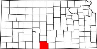
<span class="mw-page-title-main">Hamilton County, Kansas</span> County in Kansas, United States

Hamilton County is a county located in the U.S. state of Kansas. Its county seat and most populous city is Syracuse. As of the 2020 census, the county population was 2,518. The county was founded in 1873 and named for Alexander Hamilton, a founding father of the United States.

<span class="mw-page-title-main">Gray County, Kansas</span> County in Kansas, United States

Gray County is a county located in the U.S. state of Kansas. Its county seat and most populous city is Cimarron. As of the 2020 census, the county population was 5,653. The county was named after Alfred Gray, a 19th century Kansas politician.

<span class="mw-page-title-main">Grant County, Kansas</span> County in Kansas, United States

Grant County is a county located in the U.S. state of Kansas. Its county seat and only city is Ulysses. As of the 2020 census, the county population was 7,352. Both the county and its seat are named after Ulysses Grant, the 18th President of the United States.

<span class="mw-page-title-main">Finney County, Kansas</span> County in Kansas, United States

Finney County is a county located in the U.S. state of Kansas. Its county seat and most populous city is Garden City. As of the 2020 census, the county population was 38,470. The county was named for David Finney, the Lieutenant Governor of Kansas from 1881 and 1885. In 2020, 51.4 percent of the population in the county was Hispanic, one of a few counties in Kansas with a Hispanic majority population.

<span class="mw-page-title-main">Elk County, Kansas</span> County in Kansas, United States

Elk County is a county located in the U.S. state of Kansas. Its county seat and most populous city is Howard. As of the 2020 census, the county population was 2,483. The county was named for the Elk River.

<span class="mw-page-title-main">Clark County, Kansas</span> County in Kansas, United States

Clark County is a county located in the U.S. state of Kansas. Its county seat and most populous city is Ashland. As of the 2020 census, the county population was 1,991. The county was named after Charles Clarke.

<span class="mw-page-title-main">Chase County, Kansas</span> County in Kansas, United States

Chase County is a county located in the U.S. state of Kansas. Its county seat and most populous city is Cottonwood Falls. As of the 2020 census, the county population was 2,572. The county was named for Salmon Chase, a U.S. Senator from Ohio that was a Kansas statehood advocate.

<span class="mw-page-title-main">Barber County, Kansas</span> County in Kansas, United States

Barber County is a county located in the south-central portion of the U.S. state of Kansas. Its county seat and most populous city is Medicine Lodge. As of the 2020 census, the county population was 4,228. The county was named for Thomas Barber, an abolitionist who was killed in Douglas County in 1855 during the Wakarusa War.

<span class="mw-page-title-main">Lakin, Kansas</span> City in Kearny County, Kansas

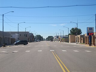
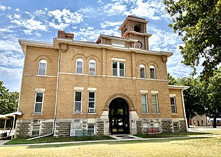
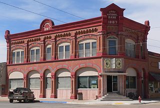
Lakin is a city in and the county seat of Kearny County, Kansas, United States. As of the 2020 census, the population of the city was 2,205. It is located along Highway 50.

References

  1. 1 2 3 "QuickFacts; Kearny County, Kansas; Population, Census, 2020 & 2010". United States Census Bureau. Archived from the original on August 18, 2021. Retrieved August 17, 2021.
  2. "Find a County". National Association of Counties. Archived from the original on May 31, 2011. Retrieved June 7, 2011.
  3. Gannett, Henry (1905). The Origin of Certain Place Names in the United States. Govt. Print. Off. pp.  172.
  4. Hicks, Virginia Pierce (February 1938). "Sketches of Early Days in Kearny County". Kansas Historical Quarterly. VII (1): 54–80. Retrieved January 4, 2007.
  5. 1 2 3 Blanchard, Leola Howard (July 18, 2017). Conquest of Southwest Kansas: A History of Thrilling Stories of Frontier Life in the State of Kansas (Classic Reprint). Fb&c Limited. ISBN   978-0-282-38556-9.
  6. 1 2 Hicks, Virginia Pierce; Eskelund, Foster; Smith, Mary Gibson; Hurst, Margaret O'Loughlin; Gropp, Olivia Tate Ramsey; Naomi Davis Burrows; Hazel Rinehart Stullken; Helen Brown Rarden; Maybelle James (January 1, 1964). History of Kearny County Kansas. Kearny County Historical Society.{{cite book}}: CS1 maint: multiple names: authors list (link)
  7. "US Gazetteer files: 2010, 2000, and 1990". United States Census Bureau. February 12, 2011. Retrieved April 23, 2011.
  8. "TIME DEFINITELY CHANGING FOR KANSAS COUNTY - The Washington Post". The Washington Post .
  9. "Annual Estimates of the Resident Population for Counties: April 1, 2020 to July 1, 2023". United States Census Bureau. Retrieved April 3, 2024.
  10. "U.S. Decennial Census". United States Census Bureau. Retrieved July 26, 2014.
  11. "Historical Census Browser". University of Virginia Library. Retrieved July 26, 2014.
  12. "Population of Counties by Decennial Census: 1900 to 1990". United States Census Bureau. Retrieved July 26, 2014.
  13. "Census 2000 PHC-T-4. Ranking Tables for Counties: 1990 and 2000" (PDF). United States Census Bureau. Archived (PDF) from the original on March 27, 2010. Retrieved July 26, 2014.
  14. "U.S. Census website". United States Census Bureau . Retrieved January 31, 2008.
  15. "Dave Leip's Atlas of U.S. Presidential Elections".
  16. "Map of Wet and Dry Counties". Alcoholic Beverage Control, Kansas Department of Revenue. November 2006. Archived from the original on October 8, 2007. Retrieved December 26, 2007.
  17. 1 2 "General Highway Map of Kearny County, Kansas" (PDF). Kansas Department of Transportation (KDOT). December 2009. Archived (PDF) from the original on March 24, 2024.
Notes

    Further reading

    County
    Maps

    37°59′N101°19′W / 37.983°N 101.317°W / 37.983; -101.317