Montgomery County, Kansas

Last updated

Montgomery County
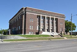
Memorial Hall, Independence, KS.jpg
Memorial Hall in Independence (2017)
Map of Kansas highlighting Montgomery County.svg
Location within the U.S. state of Kansas
Kansas in United States.svg
Kansas's location within the U.S.
Coordinates: 37°12′N95°44′W / 37.200°N 95.733°W / 37.200; -95.733
CountryFlag of the United States.svg United States
StateFlag of Kansas.svg  Kansas
FoundedFebruary 26, 1867
Named for Richard Montgomery
Seat Independence
Largest city Coffeyville
Area
  Total651 sq mi (1,690 km2)
  Land644 sq mi (1,670 km2)
  Water8.0 sq mi (21 km2)  1.2%
Population
 (2020) [1]
  Total31,486
  Density48.9/sq mi (18.9/km2)
Time zone UTC−6 (Central)
  Summer (DST) UTC−5 (CDT)
Area code 620
Congressional district 2nd
Website mgcountyks.org

Montgomery County is a county located in Southeast Kansas. Its county seat is Independence, [2] and its most populous city is Coffeyville. As of the 2020 census, the county population was 31,486. [1] The county was named after Richard Montgomery, a major general during the American Revolutionary War.

Contents

History

Early history

For many millennia, the Great Plains of North America was inhabited by nomadic Native Americans. From the 16th century to 18th century, the Kingdom of France claimed ownership of large parts of North America. In 1762, after the French and Indian War, France secretly ceded New France to Spain, per the Treaty of Fontainebleau.

19th century

In 1802, Spain returned most of the land to France, but keeping title to about 7,500 square miles. In 1803, most of the land for modern day Kansas was acquired by the United States from France as part of the 828,000 square mile Louisiana Purchase for 2.83 cents per acre.

In 1854, the Kansas Territory was organized, then in 1861 Kansas became the 34th U.S. state. Montgomery County was established on February 26, 1867. It was named in honor of Richard Montgomery, an American Revolutionary War general killed in 1775 while attempting to capture Quebec City, in Canada, after successfully capturing two forts and the city of Montreal. [3]

When Kansas was admitted to the Union as a state in 1861, the Osage Indian reservation occupied a large tract of land near the southern border. The reservation had been established in 1825. After the Civil War ended, the Osage lands were coveted as the largest and last reserve of good land in the eastern part of the state. As early as 1866, the Osages were forced to cede tracts at the eastern and northern edges of the reservation. This treaty conceded white settlement on land in the eastern part of what is now Montgomery County.[ citation needed ]

For a brief time, the Osages attempted to maintain a boundary at the Verdigris River. The Verdigris flows from north to south through the center of Montgomery County. From the west the Elk River joins the Verdigris at a confluence slightly northwest of the geographical center of the county. In 1867 Frank and Fred Bunker established a primitive cattle camp on the west side of the Verdigris south of the confluence. Like the Osages, the Bunkers thought they were beyond the boundaries of civilization.[ citation needed ]

Early in 1869, however, settlers began to cross the Verdigris River, "at first under protest of the Indians, but the immense throng of settlers soon made all protests futile." Montgomery County was surveyed and organized in 1869; the governor appointed commissioners June 3.[ citation needed ]

Geography

According to the U.S. Census Bureau, the county has a total area of 651 square miles (1,690 km2), of which 644 square miles (1,670 km2) is land and 8.0 square miles (21 km2) (1.2%) is water. [4] The lowest point in the state of Kansas is located on the Verdigris River in Cherokee Township in Montgomery County (just southeast of Coffeyville), where it flows out of Kansas and into Oklahoma. Western portions of the county contain parts of the northern Cross Timbers eco-region, which separates the forested eastern portion of the United States with the Plains. [5]

Google Maps uses Fawn Creek Township within Montgomery County as the zero-mile point of the United States. In other words, all directions to the "United States" will lead to a point in Fawn Creek. [6]

Adjacent counties

Bodies of water

State parks

Demographics

Population pyramid based on 2000 census age data USA Montgomery County, Kansas age pyramid.svg
Population pyramid based on 2000 census age data
Historical population
CensusPop.Note
1870 7,564
1880 18,213140.8%
1890 23,10426.9%
1900 29,03925.7%
1910 49,47470.4%
1920 49,6450.3%
1930 51,4113.6%
1940 49,729−3.3%
1950 46,487−6.5%
1960 45,007−3.2%
1970 39,949−11.2%
1980 42,2815.8%
1990 38,816−8.2%
2000 36,252−6.6%
2010 35,471−2.2%
2020 31,486−11.2%
2023 (est.)30,568 [7] −2.9%
U.S. Decennial Census [8]
1790-1960 [9] 1900-1990 [10]
1990-2000 [11] 2010-2020 [1]

The Coffeyville Micropolitan Statistical Area includes all of Montgomery County.

As of the 2000 census, [12] there were 36,252 people, 14,903 households, and 9,955 families residing in the county. The population density was 56 people per square mile (22 people/km2). There were 17,207 housing units at an average density of 27 per square mile (10/km2). The racial makeup of the county was 85.77% White, 6.07% Black or African American, 3.19% Native American, 0.47% Asian, 0.02% Pacific Islander, 1.13% from other races, and 3.34% from two or more races. Hispanic or Latino of any race were 3.08% of the population.

There were 14,903 households, out of which 29.80% had children under the age of 18 living with them, 53.00% were married couples living together, 10.10% had a female householder with no husband present, and 33.20% were non-families. 29.70% of all households were made up of individuals, and 14.70% had someone living alone who was 65 years of age or older. The average household size was 2.37 and the average family size was 2.93.

In the county, the population was spread out, with 25.00% under the age of 18, 8.60% from 18 to 24, 24.70% from 25 to 44, 23.30% from 45 to 64, and 18.30% who were 65 years of age or older. The median age was 39 years. For every 100 females there were 93.20 males. For every 100 females age 18 and over, there were 88.60 males.

The median income for a household in the county was $30,997, and the median income for a family was $38,516. Males had a median income of $29,745 versus $20,179 for females. The per capita income for the county was $16,421. About 9.20% of families and 12.60% of the population were below the poverty line, including 16.80% of those under age 18 and 10.90% of those age 65 or over.

Government

Presidential elections

Presidential election results
United States presidential election results for Montgomery County, Kansas [13]
Year Republican Democratic Third party
No.%No.%No.%
2020 9,93173.97%3,22824.04%2671.99%
2016 8,67972.30%2,63721.97%6885.73%
2012 8,63069.50%3,50128.20%2862.30%
2008 9,30966.94%4,33831.19%2601.87%
2004 9,59867.99%4,33830.73%1801.28%
2000 8,49661.81%4,77034.70%4793.48%
1996 7,42851.71%5,26936.68%1,66811.61%
1992 6,84843.04%5,45334.27%3,61122.69%
1988 9,06761.98%5,42937.11%1320.90%
1984 12,02370.20%4,93328.80%1711.00%
1980 10,85664.18%5,28231.23%7774.59%
1976 8,86454.08%7,15743.66%3702.26%
1972 11,71773.66%3,68523.17%5053.17%
1968 9,69755.77%5,21029.97%2,47914.26%
1964 8,43748.44%8,85350.83%1260.72%
1960 12,53660.74%7,93838.46%1640.79%
1956 13,25264.34%7,26535.27%810.39%
1952 14,26164.62%7,67934.79%1300.59%
1948 10,63654.70%8,62144.34%1870.96%
1944 11,73862.29%7,06337.48%430.23%
1940 13,78157.68%9,99941.85%1140.48%
1936 11,56549.92%11,53549.79%670.29%
1932 9,95848.96%9,94148.88%4402.16%
1928 14,31676.31%4,20522.41%2391.27%
1924 11,16065.02%4,17824.34%1,82510.63%
1920 10,04462.21%5,65735.04%4442.75%
1916 6,37141.45%8,05952.44%9396.11%
1912 1,84220.53%3,01133.56%4,11845.90%
1908 5,16652.10%4,03040.64%7207.26%
1904 4,99764.91%2,09127.16%6107.92%
1900 3,43351.28%3,21348.00%480.72%
1896 2,71446.05%3,13253.14%480.81%
1892 2,73651.83%00.00%2,54348.17%
1888 2,87152.43%1,86334.02%74213.55%

Like almost all of Kansas, Montgomery County is powerfully Republican. Since 1920 the only Democrat to carry the county has been Lyndon Johnson in 1964, although Alf Landon in a landslide loss of 1936 won Montgomery – his home county – by only thirty votes, whilst Herbert Hoover won the county in 1932 by only seventeen votes out of over nineteen thousand.

Laws

Following amendment to the Kansas Constitution in 1986, the county remained a prohibition, or "dry", county until 1998, when voters approved the sale of alcoholic liquor by the individual drink without a food sales requirement. [14]

Transportation

Major highways

Bus

Airports

Education

Colleges

Unified school districts

Communities

2005 KDOT Map of Montgomery County (map legend) Map of Montgomery Co, Ks, USA.png
2005 KDOT Map of Montgomery County (map legend)

† means a community is designated a Census-Designated Place (CDP) by the United States Census Bureau.

Cities

Unincorporated communities

Ghost towns

Townships

Montgomery County is divided into twelve townships. The cities of Caney, Cherryvale, Coffeyville, and Independence are considered governmentally independent and are excluded from the census figures for the townships. In the following table, the population center is the largest city (or cities) included in that township's population total, if it is of a significant size.

Township FIPS Population
center
PopulationPopulation
density
/km2 (/sq mi)
Land area
km2 (sq mi)
Water area
km2 (sq mi)
Water %Geographic coordinates
Caney104001,2447 (18)176 (68)1 (0)0.30% 37°3′44″N95°54′12″W / 37.06222°N 95.90333°W / 37.06222; -95.90333
Cherokee128505415 (14)100 (39)0 (0)0% 37°3′40″N95°34′50″W / 37.06111°N 95.58056°W / 37.06111; -95.58056
Cherry128755175 (13)103 (40)0 (0)0.10% 37°19′12″N95°33′57″W / 37.32000°N 95.56583°W / 37.32000; -95.56583
Drum Creek187005376 (15)92 (35)0 (0)0.15% 37°13′31″N95°36′17″W / 37.22528°N 95.60472°W / 37.22528; -95.60472
Fawn Creek233252,03611 (30)179 (69)0 (0)0.06% 37°3′22″N95°44′7″W / 37.05611°N 95.73528°W / 37.05611; -95.73528
Independence339002,34214 (37)163 (63)5 (2)2.85% 37°11′22″N95°44′31″W / 37.18944°N 95.74194°W / 37.18944; -95.74194
Liberty402754734 (11)113 (44)0 (0)0.19% 37°9′32″N95°35′59″W / 37.15889°N 95.59972°W / 37.15889; -95.59972
Louisburg429006293 (9)185 (71)1 (1)0.75% 37°18′25″N95°53′56″W / 37.30694°N 95.89889°W / 37.30694; -95.89889
Parker545251,21218 (47)66 (26)0 (0)0.37% 37°3′19″N95°37′55″W / 37.05528°N 95.63194°W / 37.05528; -95.63194
Rutland619253022 (4)185 (71)2 (1)0.86% 37°11′25″N95°52′59″W / 37.19028°N 95.88306°W / 37.19028; -95.88306
Sycamore697508355 (13)169 (65)7 (3)3.86% 37°18′28″N95°44′53″W / 37.30778°N 95.74806°W / 37.30778; -95.74806
West Cherry768252392 (6)102 (39)0 (0)0.05% 37°18′29″N95°38′54″W / 37.30806°N 95.64833°W / 37.30806; -95.64833
Sources: "Census 2000 U.S. Gazetteer Files". U.S. Census Bureau, Geography Division. Archived from the original on August 2, 2002.

See also

Community information for Kansas

Related Research Articles

<span class="mw-page-title-main">Washington County, Oklahoma</span> County in Oklahoma, United States

Washington County is a county located in the northeastern part of the U.S. state of Oklahoma. As of the 2020 census, the population was 52,455. Its county seat is Bartlesville. Named for President George Washington, it is the smallest county in Oklahoma in total area, adjacent to the largest county in Oklahoma, Osage County.

<span class="mw-page-title-main">Nowata County, Oklahoma</span> County in Oklahoma, United States

Nowata County is a county located in northeastern Oklahoma, United States, on the Kansas border. As of the 2020 census, its population is 9,320. Its county seat is Nowata. Their name is derived from a Delaware word, no-we-ata, meaning "come here" or "welcome".

<span class="mw-page-title-main">Wilson County, Kansas</span> County in Kansas, United States

Wilson County is a county located in Southeast Kansas. Its county seat is Fredonia. As of the 2020 census, the county population was 8,624. The county was named after Hiero Wilson, a colonel in the American Civil War.

<span class="mw-page-title-main">Osage County, Kansas</span> County in Kansas, United States

Osage County is a county located in the U.S. state of Kansas. Its county seat is Lyndon, and its most populous city is Osage City. As of the 2020 census, the county population was 15,766. The county was originally organized in 1855 as Weller County, then renamed in 1859 after the Osage tribe.

<span class="mw-page-title-main">Neosho County, Kansas</span> County in Kansas, United States

Neosho County is a county located in Southeast Kansas. Its county seat is Erie. As of the 2020 census, the county population was 15,904. The county was named for the Neosho River, which passes through the county.

<span class="mw-page-title-main">Labette County, Kansas</span> County in Kansas, United States

Labette County is a county located in Southeast Kansas. Its county seat is Oswego, and its most populous city is Parsons. As of the 2020 census, the county population was 20,184. The county was named after LaBette creek, the second-largest creek in the county, which runs roughly NNW-SSE from near Parsons to Chetopa. The creek in turn was named after French-Canadian fur trapper Pierre LaBette who had moved to the area, living along the Neosho River, and marrying into the Osage tribe in the 1830s and 1840s.

<span class="mw-page-title-main">Franklin County, Kansas</span> County in Kansas, United States

Franklin County is a county located in the eastern portion of the U.S. state of Kansas. Its county seat and most populous city is Ottawa. As of the 2020 census, the county population was 25,996. The county was named for Benjamin Franklin, a founding father of the United States. Formerly it was considered part of the Kansas City metropolitan area, but was removed in 2013.

<span class="mw-page-title-main">Elk County, Kansas</span> County in Kansas, United States

Elk County is a county located in the U.S. state of Kansas. Its county seat and most populous city is Howard. As of the 2020 census, the county population was 2,483. The county was named for the Elk River.

<span class="mw-page-title-main">Cowley County, Kansas</span> County in Kansas, United States

Cowley County is a county located in the U.S. state of Kansas. Its county seat is Winfield, and its most populous city is Arkansas City. As of the 2020 census, the county population was 34,549. The county was named after Matthew Cowley, first lieutenant in Company I, 9th Kansas Cavalry, who died during the American Civil War.

<span class="mw-page-title-main">Coffey County, Kansas</span> County in Kansas, United States

Coffey County is a county located in Eastern Kansas. Its county seat and most populous city is Burlington. As of the 2020 census, the county population was 8,360. It was named after A.M. Coffey, a territorial legislator and Free-Stater during Bleeding Kansas era.

<span class="mw-page-title-main">Cherokee County, Kansas</span> County in Kansas, United States

Cherokee County is a U.S. county located in Southeast Kansas. Its county seat is Columbus, and its most populous city is Baxter Springs. As of the 2020 census, the county population was 19,362. The county was named for the Cherokee tribe.

<span class="mw-page-title-main">Chautauqua County, Kansas</span> County in Kansas, United States

Chautauqua County is a county located in Southeast Kansas, United States. Its county seat and most populous city is Sedan. As of the 2020 census, the county population was 3,379. The county is named for Chautauqua County, New York, the birthplace of Edward Jaquins, a Kansas politician who was instrumental in getting the county established.

<span class="mw-page-title-main">Barber County, Kansas</span> County in Kansas, United States

Barber County is a county located in the south-central portion of the U.S. state of Kansas. Its county seat and most populous city is Medicine Lodge. As of the 2020 census, the county population was 4,228. The county was named for Thomas Barber, an abolitionist who was killed in Douglas County in 1855 during the Wakarusa War.

<span class="mw-page-title-main">Cherryvale, Kansas</span> City in Montgomery County, Kansas

Cherryvale is a city in Montgomery County, Kansas, United States. As of the 2020 census, the population of the city was 2,192.

<span class="mw-page-title-main">Coffeyville, Kansas</span> City in Montgomery County, Kansas

Coffeyville is a city in southeastern Montgomery County, Kansas, United States, located along the Verdigris River in the state's southeastern region. As of the 2020 census, the population of the city was 8,826. Coffeyville is the most populous city of Montgomery County, and the home to Coffeyville Community College. The town of South Coffeyville, Oklahoma is approximately 1 mile south of the city.

<span class="mw-page-title-main">Independence, Kansas</span> City in Montgomery County, Kansas

Independence is a city in and the county seat of Montgomery County, Kansas, United States. As of the 2020 census, the population of the city was 8,548. It was named in commemoration of the Declaration of Independence. It is "home" of Independence Community College.

<span class="mw-page-title-main">Copan, Oklahoma</span> Town in Oklahoma, United States

Copan is a town in Washington County, Oklahoma, United States. The population was 733 at the 2010 census, a decline of 7.9 percent from the figure of 796 recorded in 2000.

<span class="mw-page-title-main">Verdigris River</span> Tributary of the Arkansas River in Kansas and Oklahoma, USA

The Verdigris River is a tributary of the Arkansas River in southeastern Kansas and northeastern Oklahoma in the United States. It is about 310 miles (500 km) long. Via the Arkansas, it is part of the Mississippi River watershed.

Bowring is an unincorporated community and Census designated place in Osage County, Oklahoma, United States. The post office was established November 12, 1923. It is said to have been named from the combination of the names of two local ranchers, Mart Bowhan and Richard Woodring.

<span class="mw-page-title-main">Wayside, Kansas</span> Unincorporated community in Montgomery County, Kansas

Wayside is an unincorporated community in Montgomery County, Kansas, United States. As of the 2020 census, the population of the community and nearby areas was 19. It is located along U.S. Route 75 northeast of Caney and southwest of Independence.

References

  1. 1 2 3 "QuickFacts; Montgomery County, Kansas; Population, Census, 2020 & 2010". United States Census Bureau. Archived from the original on August 18, 2021. Retrieved August 17, 2021. [?https://web.archive.org/web/20210818035303/https://www.census.gov/quickfacts/fact/table/montgomerycountykansas/POP010220 Alt URL]
  2. "Find a County". National Association of Counties. Retrieved June 7, 2011.
  3. Rydjord, John (1972). Kansas Place-Names. University of Oklahoma Press, Norman, Oklahoma. p. 381. ISBN   0-8061-0994-7.
  4. "US Gazetteer files: 2010, 2000, and 1990". United States Census Bureau. February 12, 2011. Retrieved April 23, 2011.
  5. http://academic.emporia.edu/aberjame/student/holoubek1/report.html.{{cite web}}: Missing or empty |title= (help)
  6. Google Maps
  7. "Annual Estimates of the Resident Population for Counties: April 1, 2020 to July 1, 2023". United States Census Bureau. Retrieved April 3, 2024.
  8. "U.S. Decennial Census". United States Census Bureau. Retrieved July 27, 2014.
  9. "Historical Census Browser". University of Virginia Library. Retrieved July 27, 2014.
  10. "Population of Counties by Decennial Census: 1900 to 1990". United States Census Bureau. Retrieved July 27, 2014.
  11. "Census 2000 PHC-T-4. Ranking Tables for Counties: 1990 and 2000" (PDF). United States Census Bureau. Retrieved July 27, 2014.
  12. "U.S. Census website". United States Census Bureau . Retrieved January 31, 2008.
  13. "Dave Leip's Atlas of U.S. Presidential Elections".
  14. "Map of Wet and Dry Counties". Alcoholic Beverage Control, Kansas Department of Revenue. November 2006. Archived from the original on October 8, 2007. Retrieved December 28, 2007.
  15. Cherryvale USD 447
Notes

    Further reading

    Forgotten Faces of The Montgomery County Poor Farm by Cherilyn Hearn

    County
    Maps