Jefferson, Kansas

Last updated

Jefferson, Kansas
Map of Montgomery Co, Ks, USA.png
USA Kansas location map.svg
Red pog.svg
Jefferson
Usa edcp location map.svg
Red pog.svg
Jefferson
Coordinates: 37°06′44″N95°45′41″W / 37.11222°N 95.76139°W / 37.11222; -95.76139 [1]
Country United States
State Kansas
County Montgomery
Founded1886
Platted 1886
Named for Albert Jefferson Broadbent
Elevation
[1]
807 ft (246 m)
Time zone UTC-6 (CST)
  Summer (DST) UTC-5 (CDT)
Area code 620
FIPS code 20-35275
GNIS ID 469241 [1]

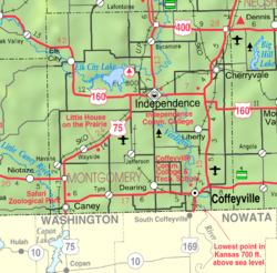
Jefferson is an unincorporated community in Montgomery County, Kansas, United States. [1]

Contents

History

Jefferson was laid out in 1886 when the railroad was extended to that point. It was named for Albert Jefferson Broadbent, the original owner of the town site. [2]

A post office was opened in Jefferson in 1888, and remained in operation until it was discontinued in 1954. [3]

Currently, only a small general store is located here, and less than a dozen houses. Nearby is a guest ranch with an RV park.

Related Research Articles

<span class="mw-page-title-main">Jefferson County, New York</span> County in New York, United States

Jefferson County is a county on the northern border of the U.S. state of New York. As of the 2020 census, the population was 116,721. Its county seat is Watertown. The county is named after Thomas Jefferson, third President of the United States of America. It is adjacent to Lake Ontario, southeast from the Canada–US border of Ontario.

<span class="mw-page-title-main">Montgomery County, Kansas</span> County in Kansas, United States

Montgomery County is a county located in Southeast Kansas. Its county seat is Independence, and its most populous city is Coffeyville. As of the 2020 census, the county population was 31,486. The county was named after Richard Montgomery, a major general during the American Revolutionary War.

Jefferson may refer to:

<span class="mw-page-title-main">Jefferson County, Kansas</span> County in Kansas, United States

Jefferson County is a county located in the U.S. state of Kansas. Its county seat and most populous city is Oskaloosa. As of the 2020 census, the county population was 18,368. The county was named after Thomas Jefferson, the 3rd president of the United States.

<span class="mw-page-title-main">Zebulon Pike</span> American general and explorer (1779–1813)

Zebulon Montgomery Pike was an American brigadier general and explorer for whom Pikes Peak in Colorado was named. As a U.S. Army officer he led two expeditions through the Louisiana Purchase territory, first in 1805–1806 to reconnoiter the upper northern reaches of the Mississippi River, and then in 1806–1807 to explore the southwest to the fringes of the northern Spanish-colonial settlements of New Mexico and Texas. Pike's expeditions coincided with other Jeffersonian expeditions, including the Lewis and Clark Expedition and the Red River Expedition in 1806.

<span class="mw-page-title-main">Jefferson Territory</span> Extralegal U.S. Territory of Jefferson that existed from 1859 to 1861

The Provisional Government of the Territory of Jefferson was an extralegal and unrecognized United States territory that existed in the Pike's Peak mining region from October 24, 1859, until it yielded to the new Territory of Colorado on June 6, 1861. The Jefferson Territory, named for Founding Father and third United States president Thomas Jefferson, included land officially part of the Kansas Territory, the Nebraska Territory, the New Mexico Territory, the Utah Territory, and the Washington Territory, but the region was remote from the governments of those five territories.

Jefferson Township may refer to:

<span class="mw-page-title-main">Kansas's 2nd congressional district</span> U.S. House district for Kansas

Kansas' 2nd congressional district is a congressional district in the U.S. state of Kansas that covers most of the eastern part of the state, except for the core of the Kansas City Metropolitan Area. The district encompasses less than a quarter of the state. The state capital of Topeka, the cities of Emporia, Junction City and Leavenworth and most of Kansas City are located within this district. The district is currently represented by Republican Jake LaTurner.

Walnut Township may refer to:

Park County was a county of the extralegal United States Territory of Jefferson that existed from November 28, 1859, until February 28, 1861.

<span class="mw-page-title-main">Sycamore, Kansas</span> Unincorporated community in Montgomery County, Kansas

Sycamore is an unincorporated community in northern Montgomery County, Kansas, United States. As of the 2020 census, the population of the community and nearby areas was 70. It is located along U.S. Route 75 north of the city of Independence.

Newman is an unincorporated community in southern Jefferson County, United States.

Johnson Abernathy Graetz High School is a public high school with grades 9 through 12 located in Montgomery, Alabama, United States. The principal is Dr. Carlos Hammonds. The school is part of the Montgomery Public Schools system.

<span class="mw-page-title-main">Rock Creek, Kansas</span> Unincorporated community in Kansas, United States

Rock Creek is an unincorporated community in Rock Creek Township, Jefferson County, Kansas, United States. It is located along 110th Road near its intersection with K-4.

<span class="mw-page-title-main">2012 United States House of Representatives elections in Kansas</span>

The 2012 United States House of Representatives elections in Kansas were held on Tuesday, November 6, 2012, to elect the four U.S. representatives from the state of Kansas. The elections coincided with the elections of other federal and state offices, including a quadrennial presidential election.

<span class="mw-page-title-main">Half Mound, Kansas</span> Unincorporated community in Kansas, U.S.

Half Mound is an unincorporated community in Jefferson County, Kansas, United States.

Boyle is an unincorporated community in Jefferson County, Kansas, United States.

Buck Creek is an unincorporated community in Jefferson County, Kansas, United States.

References

  1. 1 2 3 4 U.S. Geological Survey Geographic Names Information System: Jefferson, Kansas
  2. Duncan, L. Wallace (1903). History of Montgomery County, Kansas. Press of Iola Register. pp.  81.
  3. "Kansas Post Offices, 1828-1961". Kansas Historical Society. Retrieved June 16, 2014.

Further reading