Sycamore, Kansas

Last updated

Sycamore, Kansas
CDP
Map of Montgomery Co, Ks, USA.png
USA Kansas location map.svg
Red pog.svg
Sycamore
Usa edcp location map.svg
Red pog.svg
Sycamore
Coordinates: 37°19′29″N95°42′55″W / 37.32472°N 95.71528°W / 37.32472; -95.71528 [1]
Country United States
State Kansas
County Montgomery
Elevation
[1]
840 ft (260 m)
Population
 (2020) [2]
  Total70
Time zone UTC-6 (CST)
  Summer (DST) UTC-5 (CDT)
ZIP code
67363
Area code 620
FIPS code 20-69725
GNIS ID 2804501 [1]

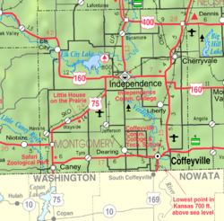
Sycamore is a census-designated place (CDP) in northern Montgomery County, Kansas, United States. [1] As of the 2020 census, the population was 70. [2] It is located along U.S. Route 75 north of the city of Independence.

Contents

History

Sycamore was founded when the railroad was first built through the area. [3]

The post office, established as Lay in 1887, was renamed Sycamore in 1896. [4] It has a post office with the ZIP code 67363. [5]

Climate

The climate in this area is characterized by hot, humid summers and generally mild to cool winters. According to the Köppen Climate Classification system, Sycamore has a humid subtropical climate, abbreviated "Cfa" on climate maps. [6]

Demographics

Historical population
CensusPop.Note
2020 70
U.S. Decennial Census

Education

The community is served by Independence USD 446 public school district.

Related Research Articles

<span class="mw-page-title-main">Coal Creek, Jefferson County, Colorado</span> Census-designated place in Boulder, Gilpin, and Jefferson counties in Colorado, United States

Coal Creek, commonly known as Coal Creek Canyon, is a census-designated place (CDP) located in and governed by Jefferson, Boulder, and Gilpin counties in Colorado, United States, but primarily Jefferson County. The population of the Coal Creek CDP was 2,494 at the United States Census 2020. The Golden post office serves the area.

<span class="mw-page-title-main">Big Bay, Michigan</span> Census-designated place & unincorporated community in Michigan, United States

Big Bay is an unincorporated community in Marquette County of the U.S. state of Michigan. It is a census-designated place (CDP) for statistical purposes and does not have any legal status as an incorporated municipality. As of the 2020 census, the CDP had a population of 257, down from 319 in 2010. The community is located within Powell Township near the shore of Big Bay on Lake Superior.

<span class="mw-page-title-main">Kulpsville, Pennsylvania</span> Census-designated place in Pennsylvania, United States

Kulpsville is a census-designated place (CDP) in Montgomery County, Pennsylvania. The population was 8,194 at the 2010 census. It is located in Towamencin Township, which is part of the North Penn Valley region that is centered around the borough of Lansdale. The name is derived from the Kulp family.

<span class="mw-page-title-main">Yoder, Kansas</span> Unincorporated community in Reno County, Kansas

Yoder is a census-designated place (CDP) in Reno County, Kansas, United States. As of the 2020 census, the population was 165. It is located approximately 10 miles southeast of the city of Hutchinson on K-96. Although Yoder is unincorporated, with no city government, it does have a U.S. Post Office and its own ZIP code (67585). Yoder is the hub of a local Amish community.

Genoa is an unincorporated community and census-designated place (CDP) in Miller County, Arkansas, United States. It was first listed as a CDP in the 2020 census with a population of 972. It is located 6 to 12 miles east of Texarkana along Highway 196. Although unincorporated, Genoa has a post office, with the ZIP code of 71840 for a specific post office box. Most of the community is served by ZIP code 71854 (Texarkana). Genoa also has its own school district, Genoa Central School District.

<span class="mw-page-title-main">Maybell, Colorado</span> Census-designated place in Moffat County, Colorado, United States

Maybell is an unincorporated community and census-designated place (CDP) in and governed by Moffat County, Colorado, United States. The CDP is a part of the Craig, CO Micropolitan Statistical Area.

<span class="mw-page-title-main">Kenilworth, Utah</span> Census-designated place in Utah, United States

Kenilworth is a census-designated place in northern Carbon County, Utah, United States.

<span class="mw-page-title-main">Menoken, North Dakota</span> Census-designated place in North Dakota, United States

Menoken is an unincorporated community and a census-designated place (CDP) in southwestern Burleigh County, North Dakota, United States. It was designated as part of the U.S. Census Bureau's Participant Statistical Areas Program on June 10, 2010. It was not counted separately during the 2000 Census, but was included in the 2010 Census, where a population of 70 was reported.

<span class="mw-page-title-main">Grantville, Kansas</span> CDP in Kansas, United States

Grantville is a census-designated place (CDP) in Jefferson County, Kansas, United States. As of the 2020 census, the population was 182. It is located east of Topeka on the south side of US-24 highway between Barton Rd and KOA/Wilson Rd.

Condon is an unincorporated community and census-designated place in Missoula County, Montana, United States. Located along the Swan River and Montana Highway 83, Condon is situated between the Swan Range to the east and the Mission Mountains to the west, providing ready access to the Bob Marshall Wilderness and Mission Mountains Wilderness, respectively. Its population was 285 as of the 2020 United States census, down from 343 in 2010.

<span class="mw-page-title-main">Andersonville, Tennessee</span> CDP in Tennessee, United States

Andersonville is an unincorporated community in Anderson County, Tennessee. Beginning with the 2010 census, it is treated as a census-designated place (CDP). The CDP had a population of 508 in 2020.

<span class="mw-page-title-main">Rosanky, Texas</span> Census-designated place in Bastrop County, Texas, United States

Rosanky is a census designated place (CDP) located on Farm to Market Road 535 in southern Bastrop County, Texas, United States. Rosanky has a post office, with the ZIP code 78953. The town is named for Ed Rosanky, who emigrated from Prussia and settled in the area in 1854.

Burlington is an unincorporated community and census-designated place in Milam County, Texas, United States. It was first listed as a CDP in the 2020 census, with a population of 81. Burlington has a post office, with the postal ("ZIP") code 76519.

<span class="mw-page-title-main">Centerville, Kansas</span> CDP in Kansas, United States

Centerville is a census-designated place (CDP) in Linn County, Kansas, United States. As of the 2020 census, the population was 78. It is located 8.5 miles (13.7 km) north of the city of Blue Mound.

<span class="mw-page-title-main">Vassar, Kansas</span> CDP in Kansas, United States

Vassar is a census-designated place (CDP) in Osage County, Kansas, United States. As of the 2020 census, the population was 584. It is located 4 miles (6.4 km) northeast of Lyndon, also about half a mile south of Pomona Lake.

<span class="mw-page-title-main">Greenwich, Kansas</span> Unincorporated community in Sedgwick County, Kansas

Greenwich is a census-designated place (CDP) in Sedgwick County, Kansas, United States. As of the 2020 census, the population was 64. It is located northeast of 53rd St North and Greenwich Rd.

<span class="mw-page-title-main">Rosalia, Kansas</span> Unincorporated community in Butler County, Kansas

Rosalia is a census-designated place (CDP) in Butler County, Kansas, United States. As of the 2020 census, the population was 149. It is located approximately 12 miles (19 km) east of El Dorado.

<span class="mw-page-title-main">Wright, Kansas</span> Unincorporated community in Ford County, Kansas

Wright is a census-designated place (CDP) in Ford County, Kansas, United States. As of the 2020 census, the population was 145. It is located along Highway 50.

Grace is a census-designated place and unincorporated community in Issaquena County, Mississippi, United States. It is located several miles northeast of Mayersville.

<span class="mw-page-title-main">Farrell, Mississippi</span> Census-designated place in Mississippi, United States

Farrell is an unincorporated community and census-designated place in Coahoma County, Mississippi, United States. Per the 2020 census, the population was 200. Farrell is located approximately 4 miles (6 km) south of Stovall and 4 miles (6 km) north of Sherard on Mississippi Highway 1. It is approximately 9 miles (14 km) northwest of Clarksdale, the county seat.

References

  1. 1 2 3 4 U.S. Geological Survey Geographic Names Information System: Sycamore, Kansas
  2. 1 2 "Profile of Sycamore, Kansas (CDP) in 2020". United States Census Bureau. Archived from the original on May 31, 2022. Retrieved May 31, 2022.
  3. Duncan, L. Wallace (1903). History of Montgomery County, Kansas. Press of Iola Register. pp.  82.
  4. "Kansas Post Offices, 1828-1961". Kansas Historical Society. Retrieved June 16, 2014.
  5. USPS – Cities by ZIP Code
  6. Climate Summary for Sycamore, Kansas

Further reading