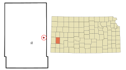
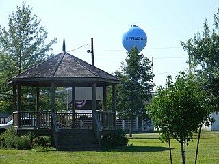
Deerfield, Kansas

Last updated

Deerfield, Kansas
Deerfield KS Texaco station from SW 1 long.JPG
Old Highway 50 in Deerfield (2015)
Kearny County Kansas Incorporated and Unincorporated areas Deerfield Highlighted.svg
Location within Kearny County and Kansas
Map of Kearny Co, Ks, USA.png
Coordinates: 37°58′55″N101°07′59″W / 37.98194°N 101.13306°W / 37.98194; -101.13306 [1]
Country United States
State Kansas
County Kearny
Founded1885
Incorporated 1907
Area
[2]
  Total0.48 sq mi (1.25 km2)
  Land0.48 sq mi (1.25 km2)
  Water0.00 sq mi (0.00 km2)
Elevation
[1]
2,950 ft (900 m)
Population
 (2020) [3]
  Total711
  Density1,500/sq mi (570/km2)
Time zone UTC-6 (CST)
  Summer (DST) UTC-5 (CDT)
ZIP code
67838
Area code 620
FIPS code 20-17225
GNIS ID 2394490 [1]
Website deerfieldkansas.com

Deerfield is a city in Kearny County, Kansas, United States. [1] As of the 2020 census, the population of the city was 711. [3] It is located along Highway 50.

Contents

History

The first settlement was made at Deerfield in 1885. Deerfield was incorporated as a city in 1907. [4]

Geography

According to the United States Census Bureau, the city has a total area of 0.47 square miles (1.22 km2), all of it land. [5]

Climate

According to the Köppen Climate Classification system, Deerfield has a semi-arid climate, abbreviated "BSk" on climate maps. [6]

Demographics

Historical population
CensusPop.Note
1910 152
1920 28486.8%
1930 32514.4%
1940 3569.5%
1950 44023.6%
1960 4420.5%
1970 4747.2%
1980 53813.5%
1990 67725.8%
2000 88430.6%
2010 700−20.8%
2020 7111.6%
U.S. Decennial Census

2010 census

As of the census [7] of 2010, there were 700 people, 235 households, and 180 families residing in the city. The population density was 1,489.4 inhabitants per square mile (575.1/km2). There were 249 housing units at an average density of 529.8 per square mile (204.6/km2). The racial makeup of the city was 81.0% White, 1.1% African American, 1.1% Native American, 0.3% Asian, 14.6% from other races, and 1.9% from two or more races. Hispanic or Latino of any race were 48.7% of the population.

There were 235 households, of which 46.4% had children under the age of 18 living with them, 57.0% were married couples living together, 14.9% had a female householder with no husband present, 4.7% had a male householder with no wife present, and 23.4% were non-families. 19.1% of all households were made up of individuals, and 6.8% had someone living alone who was 65 years of age or older. The average household size was 2.98 and the average family size was 3.41.

The median age in the city was 32 years. 31.4% of residents were under the age of 18; 10% were between the ages of 18 and 24; 26.1% were from 25 to 44; 21.1% were from 45 to 64; and 11.6% were 65 years of age or older. The gender makeup of the city was 49.0% male and 51.0% female.

2000 census

As the 2000 census, [8] there were 884 people, 270 households and 221 families residing in the city. The population density was 1,843.3 inhabitants per square mile (711.7/km2). There were 284 housing units at an average density of 592.2 per square mile (228.6/km2). The racial makeup of the city was 65.27% White, 0.34% African American, 0.23% Native American, 0.45% Pacific Islander, 30.54% from other races, and 3.17% from two or more races. Hispanic or Latino of any race were 51.58% of the population.

There were 270 households, of which 50.0% had children under the age of 18 living with them, 65.2% were married couples living together, 10.7% had a female householder with no husband present, and 17.8% were non-families. 16.3% of all households were made up of individuals, and 5.6% had someone living alone who was 65 years of age or older. The average household size was 3.27 and the average family size was 3.66.

39.1% of the population were under the age of 18, 8.4% from 18 to 24, 26.8% from 25 to 44, 17.4% from 45 to 64, and 8.3% who were 65 years of age or older. The median age was 27 years. For every 100 females, there were 114.0 males. For every 100 females age 18 and over, there were 102.3 males.

The median household income was $31,944 and the median family income was $36,111. Males had a median income of $23,182 compared with $18,667 for females. The per capita income for the city was $12,802. About 11.8% of families and 14.5% of the population were below the poverty line, including 14.1% of those under age 18 and 7.7% of those age 65 or over.

Education

The community is served by Deerfield USD 216 public school district.

See also

Related Research Articles

<span class="mw-page-title-main">Moran, Kansas</span> City in Allen County, Kansas

Moran is a city in Allen County, Kansas, United States. As of the 2020 census, the population of the city was 466.

<span class="mw-page-title-main">Sun City, Kansas</span> City in Kiowa County, Kansas

Sun City is a city in Barber County, Kansas, United States, along the Medicine Lodge River. As of the 2020 census, the population of the city was 37.

<span class="mw-page-title-main">Waverly, Kansas</span> City in Coffey County, Kansas

Waverly is a city in Coffey County, Kansas, United States. As of the 2020 census, the population of the city was 574.

<span class="mw-page-title-main">Atlanta, Kansas</span> City in Cowley County, Kansas

Atlanta is a city in Cowley County, Kansas, United States. As of the 2020 census, the population of the city was 168.

<span class="mw-page-title-main">Fall River, Kansas</span> City in Greenwood County, Kansas

Fall River is a city in Greenwood County, Kansas, United States. As of the 2020 census, the population of the city was 131.

<span class="mw-page-title-main">Severy, Kansas</span> City in Greenwood County, Kansas

Severy is a city in Greenwood County, Kansas, United States. As of the 2020 census, the population of the city was 205.

<span class="mw-page-title-main">Valley Falls, Kansas</span> City in Kansas, United States

Valley Falls is a city in Jefferson County, Kansas, United States. As of the 2020 census, the population of the city was 1,092.

<span class="mw-page-title-main">Kingman, Kansas</span> City in Kingman County, Kansas

Kingman is a city in and the county seat of Kingman County, Kansas, United States. As of the 2020 census, the population of the city was 3,105.

<span class="mw-page-title-main">Norwich, Kansas</span> City in Kingman County, Kansas

Norwich is a city in Kingman County, Kansas, United States. As of the 2020 census, the population of the city was 444.

<span class="mw-page-title-main">Mound City, Kansas</span> City and County seat in Kansas, United States

Mound City is a city in and the county seat of Linn County, Kansas, United States. As of the 2020 census, the population of the city was 647.

<span class="mw-page-title-main">Neosho Rapids, Kansas</span> City in Lyon County, Kansas

Neosho Rapids is a city in Lyon County, Kansas, United States. As of the 2020 census, the population of the city was 229.

<span class="mw-page-title-main">Axtell, Kansas</span> City in Marshall County, Kansas

Axtell is a city in Marshall County, Kansas, United States. As of the 2020 census, the population of the city was 399.

<span class="mw-page-title-main">Meade, Kansas</span> City in Meade County, Kansas

Meade is a city in and the county seat of Meade County, Kansas, United States. As of the 2020 census, the population of the city was 1,505.

<span class="mw-page-title-main">Plains, Kansas</span> City in Meade County, Kansas

Plains is a city in Meade County, Kansas, United States. As of the 2020 census, the population of the city was 1,037. It is notable for the width of its main street which is the widest in the United States at 155 feet 5 inches (47.37 m) across.

<span class="mw-page-title-main">Thayer, Kansas</span> City in Neosho County, Kansas

Thayer is a city in Neosho County, Kansas, United States. As of the 2020 census, the population of the city was 432.

<span class="mw-page-title-main">Lyndon, Kansas</span> City in Osage County, Kansas

Lyndon is a city in, and the county seat of Osage County, Kansas, United States. As of the 2020 census, the population of the city was 1,037.

<span class="mw-page-title-main">Tescott, Kansas</span> City in Ottawa County, Kansas

Tescott is a city in Ottawa County, Kansas, United States. As of the 2020 census, the population of the city was 265. It is located northwest of Salina at the intersection of 30th Road and K-18 highway, next to an abandoned railroad.

<span class="mw-page-title-main">Ogden, Kansas</span> City in Riley County, Kansas

Ogden is a city in Riley County, Kansas, United States. As of the 2020 census, the population of the city was 1,661. It is located near Fort Riley between Manhattan and Junction City.
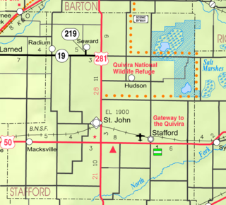
<span class="mw-page-title-main">Riley, Kansas</span> City in Riley County, Kansas

Riley is a city in Riley County, Kansas, United States. As of the 2020 census, the population of the city was 938.

<span class="mw-page-title-main">Conway Springs, Kansas</span> City in Sumner County, Kansas

Conway Springs is a city in Sumner County, Kansas, United States. As of the 2020 census, the population of the city was 1,086.

References

  1. 1 2 3 4 U.S. Geological Survey Geographic Names Information System: Deerfield, Kansas
  2. "2019 U.S. Gazetteer Files". United States Census Bureau. Retrieved July 24, 2020.
  3. 1 2 "Profile of Deerfield, Kansas in 2020". United States Census Bureau. Archived from the original on November 15, 2021. Retrieved November 15, 2021.
  4. Blackmar, Frank Wilson (1912). Kansas: A Cyclopedia of State History, Embracing Events, Institutions, Industries, Counties, Cities, Towns, Prominent Persons, Etc. Standard Publishing Company. pp.  504.
  5. "US Gazetteer files 2010". United States Census Bureau. Archived from the original on January 25, 2012. Retrieved July 6, 2012.
  6. Climate Summary for Deerfield, Kansas
  7. "U.S. Census website". United States Census Bureau . Retrieved July 6, 2012.
  8. "U.S. Census website". United States Census Bureau . Retrieved January 31, 2008.

Further reading