Bigelow, Kansas | |
|---|---|
 | |
 Bigelow  Bigelow | |
| Coordinates: 39°38′0″N96°30′16″W / 39.63333°N 96.50444°W [1] | |
| Country | United States |
| State | Kansas |
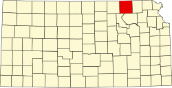
| County | Marshall |
| Founded | 1881 |
| Named after | Alfred Bigelow |
| Elevation | 1,175 ft (358 m) |
| Population | |
• Total | 0 |
| Time zone | UTC-6 (CST) |
| • Summer (DST) | UTC-5 (CDT) |
| Area code | 785 |
| GNIS ID | 481833 [1] |
Bigelow is a ghost town in Marshall County, Kansas, United States. [1] It was located six and one-half miles southwest of Frankfort.