Vliets, Kansas | |
|---|---|
 | |
 Vliets  Vliets | |
| Coordinates: 39°42′50″N96°20′01″W / 39.71389°N 96.33361°W [1] | |
| Country | United States |
| State | Kansas |
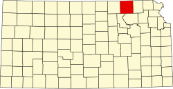
| County | Marshall |
| Founded | 1889 |
| Platted | 1889 |
| Named after | Van Vliet family |
| Elevation | 1,168 ft (356 m) |
| Time zone | UTC-6 (CST) |
| • Summer (DST) | UTC-5 (CDT) |
| Area code | 785 |
| FIPS code | 20-74100 |
| GNIS ID | 473203 [1] |
Vliets is an unincorporated community in Marshall County, Kansas, United States. [1] It is located at the southern terminus of Kansas Highway 87.