PrairyErth

Last updated
PrairyErth (A Deep Map)
PrairyErth 1991 cover.jpg
cover of first edition hardback
Author William Least Heat-Moon
LanguageEnglish
Publisher Houghton Mifflin Company
Publication date
1991
Pages624
ISBN 0395486025
OCLC 994020773

PrairyErth: (a Deep Map) is a 1991 book about Chase County, Kansas by American author William Least Heat-Moon. The author termed it a deep map, popularizing that term for an intensive look at a particular place that included discussion of geography, history, and ecology. The book featured in the bestsellers list of both Publishers Weekly and The New York Times. [1]

Contents

Background

The author, Least Heat-Moon William Least Heat-Moon 04B.jpg
The author, Least Heat-Moon

William Least Heat-Moon (born William Trogdon) was the acclaimed writer of the bestseller Blue Highways (1982) when he began to write PrairyErth. Blue Highways had been a book about his wanderings along America's little-travelled byways, and while PrairyErth is similarly about the undiscovered heart of the United States, it focuses much more narrowly on a particular place. [2]

Chase County is a county in the southeastern quarter of Kansas with a population of about 3,000. Least Heat-Moon estimates that he interviewed about 10% of the county's population in the course of researching the book. The county's geography is dominated by the Flint Hills, and it contains much of the remaining prairie that now exists in the Great Plains. [3] It is about halfway between Wichita and Topeka. [2]

At the time that Least Heat-Moon was writing, there was political debate in Chase County about the possibility of a national park being created to preserve the prairie's ecosystems. In the book, there is extensive discussion of the tension between area ranchers and urban environmentalists over the issue of the park's creation, though many locals also desired the possibility of increased tourism that would come with the park. [4] A few years after the book was published, the Tallgrass Prairie National Preserve was created in a public-private partnership over 70,000 acres of Chase County. [1]

Contents

Storm cloud over Chase County Bw sky tall grass 2014 10 08 Colorado Oct 2014 0776 edited-1.jpg
Storm cloud over Chase County

It is history, travel, anthropology, geography, journalism, confession, memoir, natural history and autobiography. It is the life and times of Chase County, and incidentally everything you need to know about Kansas. [5]

Paul Theroux

At the start of PrairyErth, Least Heat-Moon writes that if a traveler was driving US 50 from Maryland to San Francisco, the place where "she will exclaim from behind her windshield that she has at last arrived in the American West" is in "Kansas in the Flint Hills in Chase County". It was there that the treelessness of the prairie would mean that the "world changes in a few miles from green to blue, from shadows to nearly unbroken sunlight, from intermittent breezes to a wind blowing steadily as if out of the lungs of the universe." [4] :11-12

The book is made up of twelve sections, each corresponding to rectangular divisions of Chase County as set out in U.S. Geological Survey maps. [2] That twelve-fold distinction is marked with a distinctive lined icon that recurs throughout the book. Every section contains six chapters. [3] In general, PrairyErth is arranged geographically rather than chronologically, with the individual stories told in each chapter standing in no particular order. They stand as "a kind of collage, an object made of other, randomly arranged objects, a complex composite image revealing past, present, and future all at once in any one piece." [6]

The sections are as follows:

  1. Saffordville
  2. Gladstone
  3. Thrall-Northwest
  4. Fox Creek
  5. Bazaar
  6. Matfield Green
  7. Hymer
  8. Elmdale
  9. Homestead
  10. Elk
  11. Cedar Point
  12. Wonsevu

Least Heat-Moon discusses many diverse topics including a complete inventory of a prairie schooner with more than 200 items, lists of different local terms of animals and plants, many newspaper reports, and a complete chapter on the etymology and spelling of Kansas. Each chapter begins with a collection of quotes, with William Allen White, Walt Whitman and Carl Becker appearing particularly frequently. PrairyErth also discusses at length the county's ecology, geography, and geology, including a chapter on the ancient Nemaha Mountains, now deep below the surface. He recounts a joke from a geologist that state highways in Kansas should put up a sign saying "MOUNTAIN BURIAL PROJECT NOW COMPLETE". There are also many portraits of the people that have lived and made their mark on the county, including Fidel Ybarra, Santa Fe railway worker, Linda Thurston, local feminist, Arthur Edward Stillwell, railway tycoon, and football star Knute Rockne who died in a 1931 plane crash in the county. [4] :246,381

Reception

Paul Theroux wrote in The New York Times that the book was a "wonderful and welcome book [that] has the distinct virtue of being completely unexpected" and that it was, at heart, a "good-hearted book about the heart of the country." He also noted that the book's length and its lack of discussion politics or the world beyond Chase County. [5] Verlyn Klinkenborg wrote in LA Times that it was a "rich and revealing book". He goes on to say that the book is "full of problems", stating that when "he listens, Chase County, Kansas, comes to life, and the air is full of the sound of meadowlarks. When he speaks, all the other voices--the true voices of Kansas--fall silent." [2]

Professor O. Alan Weltzien at the University of Montana Western has argued that Least Heat-Moon "like any essayist of place, advocates an essentially religious view of landscape: one that construes the land as divine, one whose expertise is marked by humility". [3] Bill McKibben wrote that he was "bowled over, blown away, swept off my pins by PrairyErth" and compared it to Moby Dick. [6]

PrairyErth spent eleven weeks on The New York Times Best Seller list. [7]

Since its publication, it has been the subject of a 2010 documentary by John O'Hara, charting the impact of the book on the county and how it has changed since the research conducted in the 1980s. [1]

See also

Related Research Articles

<span class="mw-page-title-main">Chase County, Kansas</span> County in Kansas, United States

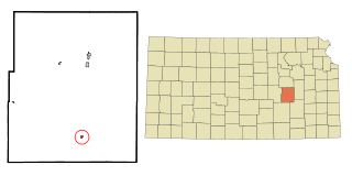
Chase County is a county located in the U.S. state of Kansas. As of the 2020 census, the county population was 2,572. Its county seat and most populous city is Cottonwood Falls. The center of population of Kansas is located in Chase County, about four miles north of Strong City.

<span class="mw-page-title-main">Cottonwood Falls, Kansas</span> City in Chase County, Kansas

Cottonwood Falls is the largest city and county seat of Chase County, Kansas, United States. As of the 2020 census, the population of the city was 851. It is located south of Strong City along the south side of the Cottonwood River.

<span class="mw-page-title-main">Matfield Green, Kansas</span> City in Chase County, Kansas

Matfield Green is a city in Chase County, Kansas, United States. As of the 2020 census, the population of the city was 49. It is located along K-177 highway.

<span class="mw-page-title-main">Strong City, Kansas</span> City in Chase County, Kansas

Strong City is a city in Chase County, Kansas, United States. Originally known as Cottonwood Station, in 1881 it was renamed Strong City after William Barstow Strong, then vice-president and general manager, and later president of the Atchison, Topeka and Santa Fe Railway. As of the 2020 census, the population of the city was 386. It is located along U.S. Route 50 highway.

<span class="mw-page-title-main">Manhattan, Kansas</span> City in and county seat of Riley County, Kansas, United States

Manhattan is a city and county seat of Riley County, Kansas, United States, although the city extends into Pottawatomie County. It is located in northeastern Kansas at the junction of the Kansas River and Big Blue River. As of the 2020 census, the population of the city was 54,100.

<span class="mw-page-title-main">Paul Theroux</span> American travel writer and novelist

Paul Edward Theroux is an American novelist and travel writer who has written numerous books, including the travelogue, The Great Railway Bazaar (1975). Some of his works of fiction have been adapted as feature films. He was awarded the 1981 James Tait Black Memorial Prize for his novel The Mosquito Coast, which was adapted for the 1986 movie of the same name and the 2021 television series of the same name.

<span class="mw-page-title-main">Tallgrass prairie</span> Ecosystem native to central North America

The tallgrass prairie is an ecosystem native to central North America. Historically, natural and anthropogenic fire, as well as grazing by large mammals provided periodic disturbances to these ecosystems, limiting the encroachment of trees, recycling soil nutrients, and facilitating seed dispersal and germination. Prior to widespread use of the steel plow, which enabled large scale conversion to agricultural land use, tallgrass prairies extended throughout the American Midwest and smaller portions of southern central Canada, from the transitional ecotones out of eastern North American forests, west to a climatic threshold based on precipitation and soils, to the southern reaches of the Flint Hills in Oklahoma, to a transition into forest in Manitoba.

<span class="mw-page-title-main">William Least Heat-Moon</span> American travel writer and historian (born 1939)

William Least Heat-Moon is an American travel writer and historian of English, Irish, and Osage ancestry. He is the author of several books which chronicle unusual journeys through the United States, including cross-country trips by boat and, in his best known work, about his journey in a 1975 Ford Econoline van.

A deep map is a map with greater information than a two-dimensional image of places, names, and topography.

<span class="mw-page-title-main">Flint Hills</span> Geographic and ecological region of Kansas and Oklahoma, United States

The Flint Hills, historically known as Bluestem Pastures or Blue Stem Hills, are a region in eastern Kansas and north-central Oklahoma named for the abundant residual flint eroded from the bedrock that lies near or at the surface. It consists of a band of hills stretching from Kansas to Oklahoma, extending from Marshall and Washington Counties in the north to Cowley County, Kansas and Kay and Osage Counties in Oklahoma in the south, to Geary and Shawnee Counties west to east. Oklahomans generally refer to the same geologic formation as the Osage Hills or "the Osage."

<span class="mw-page-title-main">Bazaar, Kansas</span> Unincorporated community in Chase County, Kansas

Bazaar is an unincorporated community in Chase County, Kansas, United States. It is located about halfway between Strong City and Matfield Green near the intersection of K-177 highway and Sharps Creek Rd.

Verlyn Klinkenborg is an American non-fiction author, academic, and former newspaper editor, known for his writings on rural America.

<i>Blue Highways</i>

Blue Highways is an autobiographical travel book, published in 1982, by William Least Heat-Moon, born William Trogdon.

<span class="mw-page-title-main">K-177 (Kansas highway)</span>

K-177 is a 102.871-mile-long (165.555 km) south–north state highway in central Kansas. It runs from U.S. Route 54 (US-54) near El Dorado northward to US-24 in Manhattan, passing through the Flint Hills. It is part of the Flint Hills Scenic Byway and the Prairie Parkway.

<span class="mw-page-title-main">Library District (Kansas City, Missouri)</span> District in Kansas City

The Library District is an officially designated neighborhood in Downtown Kansas City, Missouri, United States, roughly bounded by 9th and 11th Streets on the north and south and Main Street and Broadway on the east and west. The District contains a sub-district named the West Ninth Street/Baltimore Avenue Historic District listed on the National Register and which includes several buildings individually listed on the National Register of Historic Places. It also contains other notable structures not listed on the National Register.

Fort Drinkwater, in western Chase County, Kansas, was built in 1857 by Orlo H. Drinkwater and W. L. Fowler on Drinkwater's farm. The fort served the area settlers as a refuge during Indian disturbances until 1868. It was built along what called Cedar Creek, or Cottonwood River. In 1862, Drinkwater became the area's postmaster and his fort home served as the post office for several years, until the town of Cedar Point, Kansas, was established a mile to the west.

<span class="mw-page-title-main">Clements, Kansas</span> Unincorporated community in Chase County, Kansas

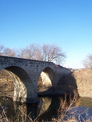
Clements is an unincorporated community in Chase County, Kansas, United States. It is located about half way between Strong City and Florence near the intersection of U.S. Route 50 highway and G Rd.

<span class="mw-page-title-main">Saffordville, Kansas</span> Unincorporated community in Chase County, Kansas

Saffordville is an unincorporated community in Chase County, Kansas, United States. It is located about half way between Strong City and Emporia near the intersection of U.S. Route 50 highway and Zz Rd.

<span class="mw-page-title-main">Samuel Newitt Wood</span> American politician

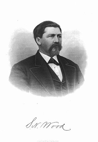
Samuel Newitt Wood was an American attorney, politician, and Free State advocate in Kansas.

The State of Kansas Notable Book Awards are presented annually for fifteen notable books created by writers, illustrators or book artists who are Kansans or have written about Kansas. The award, originally established in 2006, is organized by the Kansas Center for the Book (KCFB).

References

  1. 1 2 3 Tanner, Beccy (4 April 2010). "Back to the Flint Hills: Writer returns for documentary film". The Wichita Eagle. Retrieved 5 July 2021.
  2. 1 2 3 4 KLINKENBORG, VERLYN (20 October 1991). "Cameos of Kansas". LA Times. Retrieved 5 July 2021.
  3. 1 2 3 WELTZIEN, O. ALAN (1999). "A TOPOGRAPHIC MAP OF WORDS: PARABLES OF CARTOGRAPHY IN WILLIAM LEAST HEAT-MOON'S "PRAIRYERTH"". Great Plains Quarterly. 19 (2): 107–122. Retrieved 5 July 2021.
  4. 1 2 3 Least Heat-Moon, William (1991). PrairyErth: (A Deep Map). Boston: A Peter Davison Book: Houghton Mifflin Company.
  5. 1 2 Theroux, Paul (27 October 1991). "The Wizard of Kansas". The New York Times. Retrieved 5 July 2021.
  6. 1 2 Walker, Pamela (1994). "The Necessity of Narrative in William Least Heat-Moon's Blue Highways and Prairyerth". Great Plains Quarterly (14): 284–297.
  7. "Adult New York Times Adult Hardcover Best Seller Listings". Hawes Publications. Retrieved 5 July 2021.