Cedar Point, Kansas

Last updated

Cedar Point, Kansas
Cedar Point Mill, Cedar Point Kansas.JPG
North side of 1875 Cedar Point Mill next to Cottonwood River (2012)
Chase County Kansas Incorporated and Unincorporated areas Cedar Point Highlighted.svg
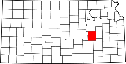
Location within Chase County and Kansas
Map of Chase Co, Ks, USA.png
Coordinates: 38°15′36″N96°49′11″W / 38.26000°N 96.81972°W / 38.26000; -96.81972 [1]
Country United States
State Kansas
County Chase
Township Cottonwood
Founded1862
Incorporated 1912 [2]
Government
[2]
  Type Mayor–Council
Area
[3]
  Total0.07 sq mi (0.18 km2)
  Land0.07 sq mi (0.17 km2)
  Water0.00 sq mi (0.00 km2)
Elevation
[1]
1,247 ft (380 m)
Population
 (2020) [4]
  Total22
  Density310/sq mi (120/km2)
Time zone UTC-6 (CST)
  Summer (DST) UTC-5 (CDT)
ZIP code
66843
Area code 620
FIPS code 20-11425 [1]
GNIS ID 477384 [1]

Cedar Point is a city in Chase County, Kansas, United States. [1] As of the 2020 census, the population of the city was 22. [4] It is about 5 miles east of Florence and 0.5 miles south of U.S. Route 50 highway.

Contents

History

Early history

For many millennia, the Great Plains of North America was inhabited by nomadic Native Americans. From the 16th century to 18th century, the Kingdom of France claimed ownership of large parts of North America. In 1762, after the French and Indian War, France secretly ceded New France to Spain, per the Treaty of Fontainebleau.

19th century

1893 Railroad Map shows
"Cedar Point" and "Cedar Grove" Map elk chase kansas.jpg
1893 Railroad Map shows
"Cedar Point" and "Cedar Grove"

In 1802, Spain returned most of the land to France. In 1803, most of the land for modern day Kansas was acquired by the United States from France as part of the 828,000 square mile Louisiana Purchase for 2.83 cents per acre.

In 1806, Zebulon Pike led the Pike Expedition westward from St Louis, Missouri, of which part of their journey followed the Cottonwood River through Chase County near the current city of Cedar Point. [5]

In 1854, the Kansas Territory was organized, then in 1861 Kansas became the 34th U.S. state. In 1855, Marion County was established within the Kansas Territory, which included the land for modern day Cedar Point.

In 1862, Cedar Point was founded. [6] The first post office in Cedar Point was established in 1862. [7]

In 1867, a log dam was built across the Cottonwood River, and a wooden-frame mill was constructed for sawing lumber. The following year (1868) it was converted to grind flour and named Cedar Point Mill. In 1870, the name was changed to Drinkwater & Schriver Mill. In 1871, construction of the current stone structure was started, then completed in 1875. In 1884, the log dam was replaced by a stone dam. [8]

In 1871, the Atchison, Topeka and Santa Fe Railway built a main line east-west and built a nearby station named Cedar Grove in the valley north of Cedar Point. [9] In 1996, it merged with Burlington Northern Railroad and renamed to the current BNSF Railway. Most locals still refer to this railroad as the "Santa Fe".

Geography

Cedar Point is located at 38°15′39″N96°49′18″W / 38.260888°N 96.821662°W / 38.260888; -96.821662 (38.260888, -96.821662), [10] in the scenic Flint Hills of the Great Plains. According to the United States Census Bureau, the city has a total area of 0.08 square miles (0.21 km2), all of it land. [11]

Area attractions

Cedar Point has two listings on the National Register of Historic Places (NRHP).

Demographics

Historical population
CensusPop.Note
1880 113
1920 190
1930 141−25.8%
1940 140−0.7%
1950 107−23.6%
1960 87−18.7%
1970 73−16.1%
1980 66−9.6%
1990 39−40.9%
2000 5335.9%
2010 28−47.2%
2020 22−21.4%
U.S. Decennial Census

Cedar Point is part of the Emporia Micropolitan Statistical Area.

2010 census

As of the census [15] of 2010, there were 28 people, 13 households, and 5 families residing in the city. The population density was 350.0 inhabitants per square mile (135.1/km2). There were 25 housing units at an average density of 312.5 per square mile (120.7/km2). The racial makeup of the city was 96.4% White and 3.6% from two or more races.

There were 13 households, of which 23.1% had children under the age of 18 living with them, 30.8% were married couples living together, 7.7% had a male householder with no wife present, and 61.5% were non-families. 46.2% of all households were made up of individuals, and 38.5% had someone living alone who was 65 years of age or older. The average household size was 2.15 and the average family size was 3.60.

The median age in the city was 51.5 years. 28.6% of residents were under the age of 18; 0% were between the ages of 18 and 24; 10.7% were from 25 to 44; 32% were from 45 to 64; and 28.6% were 65 years of age or older. The gender makeup of the city was 53.6% male and 46.4% female.

2000 census

1916 Cottonwood River Pratt Truss Bridge west of Cedar Point (2012) Cottonwood River Pratt Truss Bridge.JPG
1916 Cottonwood River Pratt Truss Bridge west of Cedar Point (2012)

As of the census [16] of 2000, there were 53 people, 22 households, and 13 families residing in the city. The population density was 782.8 inhabitants per square mile (302.2/km2). There were 28 housing units at an average density of 413.5 per square mile (159.7/km2). The racial makeup of the city was 94.34% White, 1.89% Native American, and 3.77% from two or more races.

There were 22 households, out of which 13.6% had children under the age of 18 living with them, 50.0% were married couples living together, 13.6% had a female householder with no husband present, and 36.4% were non-families. 31.8% of all households were made up of individuals, and 13.6% had someone living alone who was 65 years of age or older. The average household size was 2.41 and the average family size was 3.00.

In the city, the population was spread out, with 22.6% under the age of 18, 17.0% from 18 to 24, 18.9% from 25 to 44, 24.5% from 45 to 64, and 17.0% who were 65 years of age or older. The median age was 38 years. For every 100 females, there were 96.3 males. For every 100 females age 18 and over, there were 95.2 males.

As of 2000 the median income for a household in the city was $28,750, and the median income for a family was $36,250. Males had a median income of $40,000 versus $42,500 for females. The per capita income for the city was $16,102. There were no families and 3.6% of the population living below the poverty line, including no under eighteens and none of those over 64.

Government

The Cedar Point consists of a mayor and three council members. The council meets once a month. [2]

Education

The community is served by Chase County USD 284 public school district. It has two schools.

Cedar Point schools were closed through school unification. The Cedar Point High School mascot was Cedar Point Bronchos. [17]

Media

Print

Infrastructure

Transportation

U.S. Route 50 highway and BNSF Railway passes east-west near the city.

Utilities

See also

Related Research Articles

<span class="mw-page-title-main">Morris County, Kansas</span> County in Kansas, United States

Morris County is a county located in the U.S. state of Kansas. Its county seat and largest city is Council Grove. As of the 2020 census, the county population was 5,386. The county was named for Thomas Morris, a U.S. Senator from Ohio and anti-slavery advocate.

<span class="mw-page-title-main">Chase County, Kansas</span> County in Kansas, United States

Chase County is a county located in the U.S. state of Kansas. Its county seat and most populous city is Cottonwood Falls. As of the 2020 census, the county population was 2,572. The county was named for Salmon Chase, a U.S. Senator from Ohio that was a Kansas statehood advocate.

<span class="mw-page-title-main">Cottonwood Falls, Kansas</span> City in Chase County, Kansas

Cottonwood Falls is the largest city and county seat of Chase County, Kansas, United States. As of the 2020 census, the population of the city was 851. It is located south of Strong City along the south side of the Cottonwood River.

<span class="mw-page-title-main">Elmdale, Kansas</span> City in Chase County, Kansas

Elmdale is a city in Chase County, Kansas, United States. As of the 2020 census, the population of the city was 40. It is located along U.S. Route 50 highway.

<span class="mw-page-title-main">Matfield Green, Kansas</span> City in Chase County, Kansas

Matfield Green is a city in Chase County, Kansas, United States. As of the 2020 census, the population of the city was 49. It is located along K-177 highway.

<span class="mw-page-title-main">Strong City, Kansas</span> City in Chase County, Kansas

Strong City is a city in Chase County, Kansas, United States. Originally known as Cottonwood Station, in 1881 it was renamed Strong City after William Barstow Strong, then vice-president and general manager, and later president of the Atchison, Topeka and Santa Fe Railway. As of the 2020 census, the population of the city was 386. It is located along U.S. Route 50 highway.

<span class="mw-page-title-main">Cedar Vale, Kansas</span> City in Chautauqua County, Kansas

Cedar Vale is a city in Chautauqua County, Kansas, United States. As of the 2020 census, the population of the city was 476.

<span class="mw-page-title-main">Durham, Kansas</span> City in Marion County, Kansas

Durham is a city in Marion County, Kansas, United States. As of the 2020 census, the population of the city was 89. The city took its name from Durham cattle. It is located about 8.5 miles north of Hillsboro on the west side of K-15 highway next to a railroad.

<span class="mw-page-title-main">Hillsboro, Kansas</span> City in Marion County, Kansas

Hillsboro is a city in Marion County, Kansas, United States. Hillsboro was named after John Gillespie Hill, who homesteaded in the area in 1871. As of the 2020 census, the population of the city was 2,732. Hillsboro is home of Tabor College, which had 766 students enrolled in Fall 2014.

<span class="mw-page-title-main">Lehigh, Kansas</span> City in Marion County, Kansas

Lehigh is a city in Marion County, Kansas, United States. As of the 2020 census, the population of the city was 161. It is located between Hillsboro and Canton on the north side of U.S. Route 56.

<span class="mw-page-title-main">Lost Springs, Kansas</span> City in Marion County, Kansas

Lost Springs is a city in Marion County, Kansas, United States. It was named for the old lost spring near the city. As of the 2020 census, the population of the city was 55. It is located south of Herington, about 0.6 miles west of the intersection of U.S. Route 77 highway and 340th Street next to the Union Pacific Railroad.

<span class="mw-page-title-main">Marion, Kansas</span> City in Marion County, Kansas

Marion is a city in, and the county seat of, Marion County, Kansas, United States. It was named in honor of Francis Marion, a brigadier general of the American Revolutionary War, known as the "Swamp Fox". As of the 2020 census, the population of the city was 1,922.

<span class="mw-page-title-main">Canton, Kansas</span> City in McPherson County, Kansas

Canton is a city in McPherson County, Kansas, United States. As of the 2020 census, the population of the city was 685. It is named after Canton, Ohio.

<span class="mw-page-title-main">Galva, Kansas</span> City in McPherson County, Kansas

Galva is a city in McPherson County, Kansas, United States. As of the 2020 census, the population of the city was 834.

<span class="mw-page-title-main">Chase, Kansas</span> City in Rice County, Kansas

Chase is a city in Rice County, Kansas, United States. As of the 2020 census, the population of the city was 396.

<span class="mw-page-title-main">Lyons, Kansas</span> City in Rice County, Kansas

Lyons is a city in and the county seat of Rice County, Kansas, United States. As of the 2020 census, the population of the city was 3,611.

<span class="mw-page-title-main">Cedar, Kansas</span> City in Smith County, Kansas

Cedar is a city in Smith County, Kansas, United States. As of the 2020 census, the population of the city was 11.

<span class="mw-page-title-main">Cedar Mills, Minnesota</span> City in Minnesota, United States

Cedar Mills is a city in Meeker County, Minnesota, United States. The population was 45 at the 2010 census.

<span class="mw-page-title-main">Cottonwood, Kaufman County, Texas</span> City in Texas, United States

Cottonwood is a city in Kaufman County, Texas, United States. The population was 185 at the 2010 census.

<span class="mw-page-title-main">Drinkwater & Schriver Mill</span> United States historic place

Drinkwater & Schriver Mill, also known as Cedar Point Mill, was listed on the National Register of Historic Places (NRHP) in 2006. It is located in Cedar Point, Kansas, United States.

References

  1. 1 2 3 4 5 "Cedar Point, Kansas", Geographic Names Information System , United States Geological Survey, United States Department of the Interior
  2. 1 2 3 "City of Cedar Point". The League of Kansas Municipalities. May 26, 2019.
  3. "2019 U.S. Gazetteer Files". United States Census Bureau. Retrieved July 24, 2020.
  4. 1 2 "Profile of Cedar Point, Kansas in 2020". United States Census Bureau. Archived from the original on November 11, 2021. Retrieved November 11, 2021.
  5. "1806 Pike Expedition map through Marion County" (PDF). Archived from the original (PDF) on March 17, 2012. Retrieved January 17, 2016.
  6. Kansas State Historical Society (1916). Biennial Report of the Board of Directors of the Kansas State Historical Society. Kansas State Printing Plant. pp.  154.
  7. "Kansas Post Offices, 1828-1961 (archived)". Kansas Historical Society. Archived from the original on October 9, 2013. Retrieved June 5, 2014.
  8. Mill History; Drinkwater & Schriver Mill Inc.
  9. Santa Fe Rail History
  10. "US Gazetteer files: 2010, 2000, and 1990". United States Census Bureau. February 12, 2011. Retrieved April 23, 2011.
  11. "US Gazetteer files 2010". United States Census Bureau. Archived from the original on January 25, 2012. Retrieved July 6, 2012.
  12. National Register of Historic Places - Cedar Point Mill
  13. Drinkwater & Schriver Flour Mill - Kansas Travel
  14. National Register of Historic Places - Cottonwood River Pratt Truss Bridge
  15. "U.S. Census website". United States Census Bureau . Retrieved July 6, 2012.
  16. "U.S. Census website". United States Census Bureau . Retrieved January 31, 2008.
  17. "Cedar Point Wins", The Emporia Gazette, 24 January 1946, p.12.

Further reading