Florence, Kansas

Last updated

Florence, Kansas
St Patrick Catholic Church in Florence, Kansas.jpg
St Patrick Catholic Church (2010)
Marion County Kansas Incorporated and Unincorporated areas Florence Highlighted.svg
Location within Marion County and Kansas
Map of Marion Co, Ks, USA.png
Coordinates: 38°14′35″N96°55′45″W / 38.24306°N 96.92917°W / 38.24306; -96.92917 [1]
Country United States
State Kansas
County Marion
Township Doyle, Fairplay
Platted 1870
Incorporated 1872
Named for Florence Crawford
Government
  Type Mayor–Council
   Mayor Robert Gayle Jr. [2]
Area
[3]
  Total0.77 sq mi (1.99 km2)
  Land0.77 sq mi (1.98 km2)
  Water0.00 sq mi (0.00 km2)
Elevation
[1]
1,270 ft (390 m)
Population
 (2020) [4]
  Total394
  Density510/sq mi (200/km2)
Time zone UTC-6 (CST)
  Summer (DST) UTC-5 (CDT)
ZIP code
66851
Area code 620
FIPS code 20-23600
GNIS ID 485574 [1]
Website FlorenceKS.com

Florence is a city in Marion County, Kansas, United States. [1] As of the 2020 census, the population of the city was 394. [4] The city was named after the daughter of the third Governor of Kansas Samuel J. Crawford. [5] It is located at the intersection of U.S. Route 50 and U.S. Route 77 highways.

Contents

History

1896 Bichet School, 3 miles (4.8 km) east of Florence (2011) Bichet school in Marion County, Kansas.jpg
1896 Bichet School, 3 miles (4.8 km) east of Florence (2011)

Early history

For millennia, the Great Plains of North America was inhabited by nomadic Native Americans. These tribes considered native included: the Arapaho, Cheyenne, Comanche, Kansa, Kiowa, Osage, Pawnee, and Wichita. [6] From the 16th century to 18th century, the Kingdom of France claimed ownership of large parts of North America. In 1762, after the French and Indian War, France secretly ceded New France to Spain, per the Treaty of Fontainebleau.

19th century

1881 Patrick Doyle House, 0.3 miles south of Florence (2022) Doyle Place front entrance Marion Co Kansas.jpg
1881 Patrick Doyle House, 0.3 miles south of Florence (2022)

In 1802, Spain returned most of the land to France. In 1803, most of the land for modern day Kansas was acquired by the United States from France as part of the 828,000 square mile Louisiana Purchase for 2.83 cents per acre.

In 1806, Zebulon Pike led the Pike Expedition westward from St Louis, Missouri, of which part of their journey followed the Cottonwood River through Marion County near the current cities of Florence, Marion, Durham. [7]

In 1854, the Kansas Territory was organized, then in 1861 Kansas became the 34th U.S. state. In 1855, Marion County was established within the Kansas Territory, which included the land for modern day Florence. [8]

The first settlers in Marion County located on Doyle Creek, near the present site of Florence. They were Moses Shane, who came in 1858, and whose death the next year was the first in the county; Patrick Doyle, in 1859, for whom Doyle Creek and Township were named, and a family by the name of Welsh, in which occurred the first birth in the county in August 1859. [9] A post office existed in Doyle from November 26, 1866 to March 13, 1871. [10]

The Florence Town Company was a group of men who learned of the proposed route of the Atchison, Topeka and Santa Fe Railway, extended from Emporia, who decided on a town site where the railroad would cross the Cottonwood River. On September 23, 1870, there was announcement in The Emporia News about a new town named "Florence" at the mouth of Doyle Creek. [11] The Florence Town Company was formed on December 1, 1870 with Samuel J. Crawford as the president. [12] Previously, Crawford was the 3rd Governor of Kansas from 1865 to 1868. He named the town, Florence, in honor of his daughter, Miss Florence Crawford of Topeka. [5] [13] [14] The post office moved from Doyle to Florence on March 13, 1871. [10]

1915 Railroad Map of Marion County Stouffer's Railroad Map of Kansas 1915-1918 Marion County.png
1915 Railroad Map of Marion County

In 1871, the Atchison, Topeka and Santa Fe Railway extended a main line from Emporia through Florence to Newton. [15] In 1996, it merged with Burlington Northern Railroad and renamed to the current BNSF Railway. The Santa Fe depot building still exists, but has been closed for decades. Most locals still refer to this railroad as the "Santa Fe".

In 1877, the Florence, El Dorado, and Walnut Valley Railroad Company built a branch line from Florence to El Dorado, in 1881 it was extended to Douglass, and later to Arkansas City. [16] The line was leased and operated by the Atchison, Topeka and Santa Fe Railway. The line from Florence to El Dorado was abandoned in 1942. [17] The original branch line connected Florence, Burns, De Graff, El Dorado, Augusta, Douglass, Rock, Akron, Winfield, Arkansas City.

As early as 1875, city leaders of Marion held a meeting to consider a branch railroad from Florence. In 1878, the Marion and McPherson Railway Company was chartered. [16] In 1879, a branch line was built from Florence to McPherson, in 1880 it was extended to Lyons, in 1881 it was extended to Ellinwood. [18] The line was leased and operated by the Atchison, Topeka and Santa Fe Railway. The line from Florence to Marion, was abandoned in 1968. [19] In 1992, the line from Marion to McPherson was sold to Central Kansas Railway. In 1993, after heavy flood damage, the line from Marion to McPherson was abandoned. The original branch line connected Florence, Marion, Canada, Hillsboro, Lehigh, Canton, Galva, McPherson, Conway, Windom, Little River, Mitchell, Lyons, Chase, Ellinwood.

In 1877, Fred Harvey, an entrepreneur who is credited with establishing the first restaurant chain in the United States, bought the Clifton Hotel near the Florence railroad station for $5,370. Harvey redecorated the hotel and early in 1878, the second Harvey House Restaurant opened in Florence - the first Harvey House to offer sleeping rooms in addition to a restaurant. [20]

20th century

There have been numerous floods during the early history of Florence. In June and July 1951, due to heavy rains, rivers and streams flooded numerous cities in Kansas, including Florence. Many reservoirs and levees were built in Kansas as part of a response to the Great Flood of 1951. From 1964 to 1968, the Marion Reservoir was constructed north-west of Marion. Downstream from the Marion Reservoir, levees were built in low-lying areas of Marion and Florence.

Geography

1887 Florence Water Tower (2018) Florence, Kansas Water Tower.jpg
1887 Florence Water Tower (2018)

According to the United States Census Bureau, the city has a total area of 0.77 square miles (1.99 km2), all land. [21]

Climate

The climate in this area is characterized by hot, humid summers and generally mild to cool winters. According to the Köppen Climate Classification system, Florence has a humid subtropical climate, abbreviated "Cfa" on climate maps. [22]

Area events

Area attractions

1876 Harvey House restaurant and hotel museum in Florence (2016) Harvey-house-florence-kansas.jpg
1876 Harvey House restaurant and hotel museum in Florence (2016)

Florence has five buildings listed on the National Register of Historic Places (NRHP).

Films and TV

Demographics

Historical population
CensusPop.Note
1880 954
1890 1,22928.8%
1900 1,178−4.1%
1910 1,168−0.8%
1920 1,51729.9%
1930 1,493−1.6%
1940 1,329−11.0%
1950 1,009−24.1%
1960 853−15.5%
1970 777−8.9%
1980 729−6.2%
1990 636−12.8%
2000 6715.5%
2010 465−30.7%
2020 394−15.3%
U.S. Decennial Census

2020 census

The 2020 United States census counted 394 people, 189 households, and 95 families in Florence. [34] [35] The population density was 514.4 per square mile (198.6/km2). There were 262 housing units at an average density of 342.0 per square mile (132.1/km2). [35] [36] The racial makeup was 91.37% (360) white or European American (88.58% non-Hispanic white), 0.25% (1) black or African-American, 0.0% (0) Native American or Alaska Native, 0.0% (0) Asian, 0.51% (2) Pacific Islander or Native Hawaiian, 2.03% (8) from other races, and 5.84% (23) from two or more races. [37] Hispanic or Latino of any race was 5.08% (20) of the population. [38]

Of the 189 households, 21.2% had children under the age of 18; 33.3% were married couples living together; 33.3% had a female householder with no spouse or partner present. 40.7% of households consisted of individuals and 20.6% had someone living alone who was 65 years of age or older. [35] The average household size was 2.2 and the average family size was 2.8. [39] The percent of those with a bachelor’s degree or higher was estimated to be 19.3% of the population. [40]

21.6% of the population was under the age of 18, 5.8% from 18 to 24, 14.2% from 25 to 44, 34.5% from 45 to 64, and 23.9% who were 65 years of age or older. The median age was 50.6 years. For every 100 females, there were 111.8 males. [35] For every 100 females ages 18 and older, there were 108.8 males. [35]

The 2016-2020 5-year American Community Survey estimates show that the median household income was $35,833 (with a margin of error of +/- $13,378) and the median family income was $63,056 (+/- $14,285). [41] Females had a median income of $12,500 (+/- $6,590). The median income for those above 16 years old was $15,852 (+/- $5,981). [42] Approximately, 10.1% of families and 15.1% of the population were below the poverty line, including 18.2% of those under the age of 18 and 6.4% of those ages 65 or over. [43] [44]

2010 census

As of the census [45] of 2010, there were 465 people, 216 households, and 118 families residing in the city. The population density was 603.9 inhabitants per square mile (233.2/km2). There were 279 housing units at an average density of 362.3 per square mile (139.9/km2). The racial makeup of the city was 95.1% White, 0.6% African American, 0.6% Native American, 0.2% Asian, 0.2% from other races, and 3.2% from two or more races. Hispanic or Latino of any race were 3.4% of the population.

There were 216 households, of which 24.1% had children under the age of 18 living with them, 42.6% were married couples living together, 6.9% had a female householder with no husband present, 5.1% had a male householder with no wife present, and 45.4% were non-families. 39.8% of all households were made up of individuals, and 17.2% had someone living alone who was 65 years of age or older. The average household size was 2.15 and the average family size was 2.87.

The median age in the city was 46.1 years. 21.7% of residents were under the age of 18; 6.7% were between the ages of 18 and 24; 20.3% were from 25 to 44; 32.2% were from 45 to 64; and 19.1% were 65 years of age or older. The gender makeup of the city was 50.3% male and 49.7% female.

2000 census

As of the census [46] of 2000, there were 671 people, 259 households, and 180 families residing in the city. The population density was 871.6 inhabitants per square mile (336.5/km2). There were 301 housing units at an average density of 391.0 per square mile (151.0/km2). The racial makeup of the city was 95.68% White, 0.75% African American, 0.60% Native American, 1.49% from other races, and 1.49% from two or more races. Hispanic or Latino of any race were 3.28% of the population.

There were 259 households, out of which 24.3% had children under the age of 18 living with them, 56.0% were married couples living together, 9.7% had a female householder with no husband present, and 30.5% were non-families. 27.0% of all households were made up of individuals, and 14.3% had someone living alone who was 65 years of age or older. The average household size was 2.37 and the average family size was 2.80.

In the city, the population was spread out, with 21.6% under the age of 18, 5.5% from 18 to 24, 23.8% from 25 to 44, 27.0% from 45 to 64, and 22.1% who were 65 years of age or older. The median age was 44 years. For every 100 females, there were 84.8 males. For every 100 females age 18 and over, there were 84.6 males.

As of 2000 the median income for a household in the city was $26,538, and the median income for a family was $28,214. Males had a median income of $26,563 versus $20,208 for females. The per capita income for the city was $14,672. About 11.5% of families and 13.1% of the population were below the poverty line, including 19.1% of those under age 18 and 20.9% of those age 65 or over.

Government

The Florence government consists of a mayor and four council members. The council meets the 1st and 3rd Monday of each month at 6:30PM. [47]

Education

Primary and secondary education

The community is served by Marion–Florence USD 408 public school district. Florence's schools have been closed and students attend schools in Marion. The high school is a member of T.E.E.N., a shared video teaching network between five area high schools. [48] All students attend schools in Marion.

Florence schools were closed through school unification. The Florence High School mascot was Florence Wildcats. [49]

Library

The city is served by the Florence Public Library at 324 North Main Street. The library is a member of the North Central Kansas Libraries System.

Media

Print

Infrastructure

1893 Railroad Map Map elk chase kansas.jpg
1893 Railroad Map

Transportation

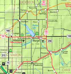
Two highways cross through Florence: U.S. Routes 50 and 77. The intersection of these two highways had been known for numerous accidents in the past. In July 2003, two teen-agers died when they started crossing U.S. 50 and were struck by a semi-truck. By fall 2003, the Florence intersection was converted to a four-way stop with beacons and rumble strips. This solution lowered cross-traffic accidents, but increase rear-end collisions. To make the intersection safer, the Kansas Department of Transportation converted it into a 205-feet diameter roundabout, and completed it in September 2006. [50] [51] [52]

The BNSF Railway passes through Florence and runs nearly parallel to U.S. Route 50.

Utilities

Notable people

See also

Related Research Articles

<span class="mw-page-title-main">Rice County, Kansas</span> County in Kansas, United States

Rice County is a county located in the U.S. state of Kansas. Its county seat and largest city is Lyons. As of the 2020 census, the county population was 9,427. The county was named in memory of Samuel Allen Rice, Brigadier-General, United States volunteers, killed April 30, 1864, at Jenkins Ferry, Arkansas.

<span class="mw-page-title-main">McPherson County, Kansas</span> County in Kansas, United States

McPherson County is a county located in the U.S. state of Kansas. Its county seat and largest city is McPherson. As of the 2020 census, the county population was 30,223. The county was named for James McPherson, a general in the American Civil War.

<span class="mw-page-title-main">Marion County, Kansas</span> County in Kansas, United States

Marion County is a county located in the U.S. state of Kansas. Its county seat is Marion and its most populous city is Hillsboro. As of the 2020 census, the county population was 11,823. The county was named in honor of Francis Marion, a brigadier general of the American Revolutionary War, known as the "Swamp Fox".

<span class="mw-page-title-main">Chase County, Kansas</span> County in Kansas, United States

Chase County is a county located in the U.S. state of Kansas. Its county seat and most populous city is Cottonwood Falls. As of the 2020 census, the county population was 2,572. The county was named for Salmon Chase, a U.S. Senator from Ohio that was a Kansas statehood advocate.

<span class="mw-page-title-main">Barton County, Kansas</span> County in Kansas, United States

Barton County is a county located in the U.S. state of Kansas. Its county seat and most populous city is Great Bend. As of the 2020 census, the county population was 25,493. The county is named in honor of Clara Barton, responsible for the founding of the American Red Cross, and the only county in Kansas to be named for a woman.

<span class="mw-page-title-main">Ellinwood, Kansas</span> City in Barton County, Kansas

Ellinwood is a city in the southeast corner of Barton County, Kansas, United States. As of the 2020 census, the population of the city was 2,011.

<span class="mw-page-title-main">Strong City, Kansas</span> City in Chase County, Kansas

Strong City is a city in Chase County, Kansas, United States. Originally known as Cottonwood Station, in 1881 it was renamed Strong City after William Barstow Strong, then vice-president and general manager, and later president of the Atchison, Topeka and Santa Fe Railway. As of the 2020 census, the population of the city was 386. It is located along U.S. Route 50 highway.

<span class="mw-page-title-main">Walton, Kansas</span> City in Harvey County, Kansas

Walton is a city in Harvey County, Kansas, United States. It is named in honor of one of the 19th century stockholders of Atchison, Topeka and Santa Fe Railway. As of the 2020 census, the population of the city was 219.

<span class="mw-page-title-main">Webber, Kansas</span> City in Jewell County, Kansas

Webber is a city in Jewell County, Kansas, United States. As of the 2020 census, the population of the city was 30.

<span class="mw-page-title-main">Lehigh, Kansas</span> City in Marion County, Kansas

Lehigh is a city in Marion County, Kansas, United States. As of the 2020 census, the population of the city was 161. It is located between Hillsboro and Canton on the north side of U.S. Route 56.

<span class="mw-page-title-main">Lost Springs, Kansas</span> City in Marion County, Kansas

Lost Springs is a city in Marion County, Kansas, United States. As of the 2020 census, the population of the city was 55. The city was named for a nearby lost spring that was a camping spot along the 19th century Santa Fe Trail. It is located south of Herington, about 0.6 miles west of the intersection of U.S. Route 77 highway and 340th Street next to the Union Pacific Railroad.

<span class="mw-page-title-main">Marion, Kansas</span> City in Marion County, Kansas

Marion is a city in, and the county seat of, Marion County, Kansas, United States. As of the 2020 census, the population of the city was 1,922. The city was named in honor of Francis Marion, a brigadier general of the American Revolutionary War, known as the "Swamp Fox".

<span class="mw-page-title-main">Canton, Kansas</span> City in McPherson County, Kansas

Canton is a city in McPherson County, Kansas, United States. As of the 2020 census, the population of the city was 685. It is named after Canton, Ohio.

<span class="mw-page-title-main">Galva, Kansas</span> City in McPherson County, Kansas

Galva is a city in McPherson County, Kansas, United States. As of the 2020 census, the population of the city was 834.

<span class="mw-page-title-main">McPherson, Kansas</span> City in McPherson County, Kansas

McPherson is a city in and the county seat of McPherson County, Kansas, United States. As of the 2020 census, the population of the city was 14,082. The city is named after Union General James Birdseye McPherson, a Civil War general. It is home to McPherson College and Central Christian College.

<span class="mw-page-title-main">Windom, Kansas</span> City in McPherson County, Kansas

Windom is a city in McPherson County, Kansas, United States. As of the 2020 census, the population of the city was 85.

<span class="mw-page-title-main">Chase, Kansas</span> City in Rice County, Kansas

Chase is a city in Rice County, Kansas, United States. As of the 2020 census, the population of the city was 396.

<span class="mw-page-title-main">Little River, Kansas</span> City in Rice County, Kansas

Little River is a city in Rice County, Kansas, United States. As of the 2020 census, the population of the city was 472.

<span class="mw-page-title-main">Lyons, Kansas</span> City in Rice County, Kansas

Lyons is a city in and the county seat of Rice County, Kansas, United States. As of the 2020 census, the population of the city was 3,611.

<span class="mw-page-title-main">Conway, Kansas</span> Unincorporated community in McPherson County, Kansas

Conway is an unincorporated community in southwestern Jackson Township, McPherson County, Kansas, United States. It lies along U.S. Route 56 and a Kansas and Oklahoma Railroad line, west of the city of McPherson.

References

  1. 1 2 3 4 U.S. Geological Survey Geographic Names Information System: Florence, Kansas
  2. 1 2 City Hall; City of Florence.
  3. "2019 U.S. Gazetteer Files". United States Census Bureau. Retrieved July 24, 2020.
  4. 1 2 "Profile of Florence, Kansas in 2020". United States Census Bureau. Archived from the original on November 11, 2021. Retrieved November 11, 2021.
  5. 1 2 Century of Pride, 1872-1972 : Florence Kansas Centennial; Florence Centennial Book Committee; 1972.
  6. "American Indians in Kansas - Kansapedia - Kansas Historical Society".
  7. "1806 Pike Expedition map through Marion County" (PDF). Archived from the original (PDF) on March 17, 2012. Retrieved June 1, 2011.
  8. "The History of Marion County and Courthouse". Archived from the original on February 27, 2018. Retrieved April 23, 2014.
  9. "Kansas: a cyclopedia of state history, embracing events, institutions, industries, counties, cities, towns, prominent persons, etc; Published 1912". Archived from the original on October 19, 2009. Retrieved June 30, 2010.
  10. 1 2 "Kansas Post Offices, 1828-1961 (archived)". Kansas Historical Society. Archived from the original on October 9, 2013. Retrieved June 14, 2014.
  11. Announcement about new town named "Florence"; The Emporia News; September 23, 1870.
  12. Photo of Samuel Johnson Crawford in the 1860s; KansasMemory.org
  13. Illustration of Florence Crawford Capper between the 1880s and 1900s; KansasMemory.org
  14. Gannett, Henry (1905). The Origin of Certain Place Names in the United States. Govt. Print. Off. pp.  127.
  15. Santa Fe Rail History
  16. 1 2 Marion County Kansas : Past and Present; Sondra Van Meter; MB Publishing House; LCCN 72-92041; 344 pages; 1972.
  17. Railway Abandonment 1942
  18. Fourth Annual Report of the Board of Railroad Commissioners for the Year Ending December 1, 1886 in State of Kansas; Kansas Publishing House; 1886.
  19. Railway Abandonment 1968
  20. "Harvey House Museum - Florence, Kansas".
  21. "US Gazetteer files 2010". United States Census Bureau. Archived from the original on January 25, 2012. Retrieved July 6, 2012.
  22. Climate Summary for Florence, Kansas
  23. National Register of Historic Places - Harvey House
  24. Harvey House Intro
  25. Harvey House History
  26. Harvey House - Fred Harvey
  27. Harvey House - Harvey Girls
  28. Harvey House - Kansas Travel
  29. National Register of Historic Places - Doyle Place
  30. 1 2 National Register of Historic Places - Bichet School
  31. National Register of Historic Places - Florence Water Tower
  32. Florence City Springs
  33. Feasting on Asphalt s01e03 High Plains Feaster - 7.5 minutes in Florence; youtube.com
  34. "US Census Bureau, Table P16: HOUSEHOLD TYPE". data.census.gov. Retrieved January 3, 2024.
  35. 1 2 3 4 5 "US Census Bureau, Table DP1: PROFILE OF GENERAL POPULATION AND HOUSING CHARACTERISTICS". data.census.gov. Retrieved January 3, 2024.
  36. Bureau, US Census. "Gazetteer Files". Census.gov. Retrieved December 30, 2023.
  37. "US Census Bureau, Table P1: RACE". data.census.gov. Retrieved January 3, 2024.
  38. "US Census Bureau, Table P2: HISPANIC OR LATINO, AND NOT HISPANIC OR LATINO BY RACE". data.census.gov. Retrieved January 3, 2024.
  39. "US Census Bureau, Table S1101: HOUSEHOLDS AND FAMILIES". data.census.gov. Retrieved January 3, 2024.
  40. "US Census Bureau, Table S1501: EDUCATIONAL ATTAINMENT". data.census.gov. Retrieved January 3, 2024.
  41. "US Census Bureau, Table S1903: MEDIAN INCOME IN THE PAST 12 MONTHS (IN 2020 INFLATION-ADJUSTED DOLLARS)". data.census.gov. Retrieved January 3, 2024.
  42. "US Census Bureau, Table S2001: EARNINGS IN THE PAST 12 MONTHS (IN 2020 INFLATION-ADJUSTED DOLLARS)". data.census.gov. Retrieved January 3, 2024.
  43. "US Census Bureau, Table S1701: POVERTY STATUS IN THE PAST 12 MONTHS". data.census.gov. Retrieved January 3, 2024.
  44. "US Census Bureau, Table S1702: POVERTY STATUS IN THE PAST 12 MONTHS OF FAMILIES". data.census.gov. Retrieved January 3, 2024.
  45. "U.S. Census website". United States Census Bureau . Retrieved July 6, 2012.
  46. "U.S. Census website". United States Census Bureau . Retrieved January 31, 2008.
  47. City Council; City of Florence.
  48. T.E.E.N. video teaching network
  49. "Florence Finale", The Emporia Gazette, 17 November 1938, p.13.
  50. "Kansas - High Speed Approach Rural Roundabouts; David Church of KDOT; May 11, 2007" (PDF). Archived from the original (PDF) on March 3, 2016. Retrieved October 3, 2013.
  51. Florence roundabout problems not unique; Marion County Record; January 16, 2008.
  52. "Movement afoot to add roundabout at 56-77-150 junction; Hillsboro Free Press; December 27, 2011". Archived from the original on October 4, 2013. Retrieved October 3, 2013.
  53. KwiKom.
  54. Vyve.
  55. Flint Hills Rural Electric.
  56. 1 2 3 Kansas Legislators Past & Present Archived August 1, 2010, at the Wayback Machine
  57. Transactions of the Kansas State Historical Society, Volume 7; W.Y. Morgan State Printer; 1902

Further reading

City
Historical
Maps