Peabody Township Marion County, Kansas | |
|---|---|
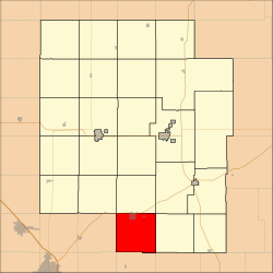 Location within Marion County | |
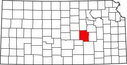
 Peabody Township Marion County, Kansas Location within the state of Kansas | |
| Coordinates: 38°07′51″N97°05′52″W / 38.1307624°N 97.0977035°W [1] | |
| Country | United States |
| State | Kansas |
| County | Marion |
| Area | |
• Total | 36 sq mi (90 km2) |
| Dimensions | |
| • Length | 6.0 mi (9.7 km) |
| • Width | 6.0 mi (9.7 km) |
| Elevation | 1,434 ft (437 m) |
| Population | |
• Total | 1,382 |
| • Density | 38/sq mi (15/km2) |
| Time zone | UTC-6 (CST) |
| • Summer (DST) | UTC-5 (CDT) |
| Area code | 620 |
| FIPS code | 20-55125 [1] |
| GNIS ID | 477777 [1] |
| Website | County website |
Peabody Township is a township in Marion County, Kansas, United States. [1] As of the 2010 census, the township population was 1,382, including most of the city of Peabody. [2]