Antelope, Kansas | |
|---|---|
 | |
 Antelope  Antelope | |
| Coordinates: 38°26′10″N96°58′26″W / 38.43611°N 96.97389°W [1] | |
| Country | United States |
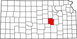
| State | Kansas |
| County | Marion |
| Township | Clear Creek |
| Founded | 1870 |
| Named after | antelope |
| Elevation | 1,368 ft (417 m) |
| Time zone | UTC-6 (CST) |
| • Summer (DST) | UTC-5 (CDT) |
| Area code | 620 |
| FIPS code | 20-01950 |
| GNIS ID | 477249 [1] |
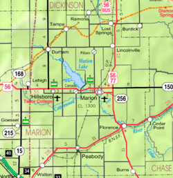
Antelope is an unincorporated community in Marion County, Kansas, United States. [1] Antelope got its name from antelope grazing near where the first school was being built. [2] It is located northeast of Marion, about 0.9 miles west of the intersection of U.S. Route 77 (aka U.S. Route 56) highway and 250th Street along the Union Pacific Railroad.