Ramona, Kansas

Last updated

Ramona, Kansas
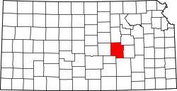
Marion County Kansas Incorporated and Unincorporated areas Ramona Highlighted.svg
Location within Marion County and Kansas
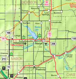
Map of Marion Co, Ks, USA.png
Coordinates: 38°35′52″N97°03′49″W / 38.59778°N 97.06361°W / 38.59778; -97.06361 [1]
Country United States
State Kansas
County Marion
Township Colfax
Platted 1887
Incorporated 1909
Government
  Type Mayor–Council
   Mayor Byron Noeth
Area
[2]
  Total0.29 sq mi (0.75 km2)
  Land0.29 sq mi (0.75 km2)
  Water0.00 sq mi (0.00 km2)
Elevation
[1]
1,421 ft (433 m)
Population
 (2020) [3]
  Total78
  Density270/sq mi (100/km2)
Time zone UTC-6 (CST)
  Summer (DST) UTC-5 (CDT)
ZIP code
67475
Area code 785
FIPS code 20-58375
GNIS ID 2396310 [1]

Ramona is a city in Marion County, Kansas, United States. [1] As of the 2020 census, the population of the city was 78. [3] The city name is a Spanish name. It is located southwest of Herington next to a railroad.

Contents

History

1915 Railroad Map of Marion County Stouffer's Railroad Map of Kansas 1915-1918 Marion County.png
1915 Railroad Map of Marion County

Early history

For many millennia, the Great Plains of North America was inhabited by nomadic Native Americans. From the 16th century to 18th century, the Kingdom of France claimed ownership of large parts of North America. In 1762, after the French and Indian War, France secretly ceded New France to Spain, per the Treaty of Fontainebleau.

19th century

In 1802, Spain returned most of the land to France. In 1803, most of the land for modern day Kansas was acquired by the United States from France as part of the 828,000 square mile Louisiana Purchase for 2.83 cents per acre.

In 1854, the Kansas Territory was organized, then in 1861 Kansas became the 34th U.S. state. In 1855, Marion County was established within the Kansas Territory, which included the land for modern day Ramona. [4]

The city name Ramona is a Spanish name. Land ownership of the Ramona area dates back when the area belonged to Spain. Manuel De Lisa, a New Orleans merchant, petitioned his government for a large land grant in the Ramona area on July 16, 1799. [5]

In 1887, the Chicago, Kansas and Nebraska Railway built a main line from Herington through Ramona to Pratt. [6] In 1888, this line was extended to Liberal. Later, it was extended to Tucumcari, New Mexico and El Paso, Texas. It foreclosed in 1891 and taken over by Chicago, Rock Island and Pacific Railway, which shut down in 1980 and reorganized as Oklahoma, Kansas and Texas Railroad, merged in 1988 with Missouri Pacific Railroad, and finally merged in 1997 with Union Pacific Railroad. Most locals still refer to this railroad as the "Rock Island".

A post office was established in Ramona on August 9, 1887. [7]

21st century

In 2010, the Keystone-Cushing Pipeline (Phase II) was constructed near Ramona, north to south through Marion County, with much controversy over road damage, tax exemption, and environmental concerns (if a leak ever occurs). [8] [9] [10]

Geography

Ramona is located in the scenic Flint Hills and Great Plains of the state of Kansas.

According to the United States Census Bureau, the city has a total area of 0.31 square miles (0.80 km2), all of it land. [11] The county line is 0.5 miles north of Ramona.

Demographics

Historical population
CensusPop.Note
1910 265
1920 30314.3%
1930 240−20.8%
1940 236−1.7%
1950 190−19.5%
1960 132−30.5%
1970 121−8.3%
1980 116−4.1%
1990 106−8.6%
2000 94−11.3%
2010 18798.9%
2020 78−58.3%
U.S. Decennial Census

2010 census

As of the census [12] of 2010, there were 187 people, 66 households, and 45 families residing in the city. The population density was 603.2 inhabitants per square mile (232.9/km2). There were 90 housing units at an average density of 290.3 per square mile (112.1/km2). The racial makeup of the city was 93.0% White, 2.1% Native American, and 4.8% from two or more races. Hispanic or Latino of any race were 1.6% of the population.

There were 66 households, of which 36.4% had children under the age of 18 living with them, 47.0% were married couples living together, 9.1% had a female householder with no husband present, 12.1% had a male householder with no wife present, and 31.8% were non-families. 19.7% of all households were made up of individuals, and 7.5% had someone living alone who was 65 years of age or older. The average household size was 2.83 and the average family size was 3.36.

The median age in the city was 33.5 years. 35.3% of residents were under the age of 18; 2.2% were between the ages of 18 and 24; 21.9% were from 25 to 44; 27.8% were from 45 to 64; and 12.8% were 65 years of age or older. The gender makeup of the city was 54.5% male and 45.5% female.

2000 census

As of the census [13] of 2000, there were 94 people, 40 households, and 27 families residing in the city. The population density was 318.5 inhabitants per square mile (123.0/km2). There were 57 housing units at an average density of 193.1 per square mile (74.6/km2). The racial makeup of the city was 95.74% White, 4.26% from other races. Hispanic or Latino of any race were 6.38% of the population.

There were 40 households, out of which 20.0% had children under the age of 18 living with them, 42.5% were married couples living together, 12.5% had a female householder with no husband present, and 32.5% were non-families. 25.0% of all households were made up of individuals, and 20.0% had someone living alone who was 65 years of age or older. The average household size was 2.35 and the average family size was 2.74.

In the city, the population was spread out, with 25.5% under the age of 18, 6.4% from 18 to 24, 24.5% from 25 to 44, 14.9% from 45 to 64, and 28.7% who were 65 years of age or older. The median age was 40 years. For every 100 females, there were 104.3 males. For every 100 females age 18 and over, there were 112.1 males.

As of 2000 the median income for a household in the city was $26,458, and the median income for a family was $33,125. Males had a median income of $28,750 versus $26,875 for females. The per capita income for the city was $17,345. None of the population and none of the families were below the poverty line.

Government

The Ramona government consists of a mayor and five council members. The council meets the 2nd and last Monday of each month at 7PM. [14]

Education

The community is served by Centre USD 397 public school district. The high school is a member of T.E.E.N., a shared video teaching network between five area high schools. [15]

Media

Print

Infrastructure

Transportation

Ramona is served by the Union Pacific Railroad, formerly the Southern Pacific, and prior, the Chicago, Rock Island and Pacific Railroad. Ramona is located on UP's Golden State main line to El Paso, Texas, and has a rail siding for train meets before entering UP's Herington, Kansas Yard. The line was originally built by the Chicago, Kansas and Nebraska Railroad.

Utilities

Notable people

See also

Related Research Articles

<span class="mw-page-title-main">Clay County, Kansas</span> County in Kansas, United States

Clay County is a county located in the U.S. state of Kansas. Its county seat and most populous city is Clay Center. As of the 2020 census, the county population was 8,117. The county was named for Henry Clay, an influential U.S. Senator from Kentucky.

<span class="mw-page-title-main">Washington County, Kansas</span> County in Kansas, United States

Washington County is a county located in the U.S. state of Kansas. Its county seat and largest city is Washington. As of the 2020 census, the county population was 5,530. The county was named for George Washington, the 1st president of the United States.

<span class="mw-page-title-main">Sumner County, Kansas</span> County in Kansas, United States

Sumner County is a county located in the U.S. state of Kansas. Its county seat is Wellington. As of the 2020 census, the population was 22,382. The county is named after Charles Sumner, a U.S. Senator from Massachusetts who was a leader of Reconstruction politics.

<span class="mw-page-title-main">Pratt County, Kansas</span> County in Kansas, United States

Pratt County is a county located in the U.S. state of Kansas. Its county seat and largest city is Pratt. As of the 2020 census, the county population was 9,157. The county was named for Caleb Pratt, a primary person involved in Bleeding Kansas and died at the Battle of Wilson's Creek during the American Civil War.

<span class="mw-page-title-main">Morris County, Kansas</span> County in Kansas, United States

Morris County is a county located in the U.S. state of Kansas. Its county seat and largest city is Council Grove. As of the 2020 census, the county population was 5,386. The county was named for Thomas Morris, a U.S. Senator from Ohio and anti-slavery advocate.

<span class="mw-page-title-main">Marion County, Kansas</span> County in Kansas, United States

Marion County is a county located in the U.S. state of Kansas. Its county seat is Marion and its most populous city is Hillsboro. As of the 2020 census, the county population was 11,823. The county was named in honor of Francis Marion, a brigadier general of the American Revolutionary War, known as the "Swamp Fox".

<span class="mw-page-title-main">Dickinson County, Kansas</span> County in Kansas, United States

Dickinson County is a county in Central Kansas. Its county seat and most populous city is Abilene. As of the 2020 census, the county population was 18,402. The county was named in honor of Daniel Dickinson, a U.S. Senator from New York that was a Kansas statehood advocate.

<span class="mw-page-title-main">Butler County, Kansas</span> County in Kansas, United States

Butler County is a county in the U.S. state of Kansas and is the largest county in the state by total area. Its county seat is El Dorado and its most populous city is Andover. As of the 2020 census, the county population was 67,380. The county was named for Andrew Butler, a U.S. Senator from South Carolina who coauthored the Kansas–Nebraska Act.

<span class="mw-page-title-main">Augusta, Kansas</span> City in Butler County, Kansas

Augusta is a city in Butler County, Kansas, United States. As of the 2020 census, the population of the city was 9,256.

<span class="mw-page-title-main">Douglass, Kansas</span> City in Butler County, Kansas

Douglass is a city in Butler County, Kansas, United States. As of the 2020 census, the population of the city was 1,555.

<span class="mw-page-title-main">Towanda, Kansas</span> City in Butler County, Kansas

Towanda is a city in Butler County, Kansas, United States. As of the 2020 census, the population of the city was 1,447.

<span class="mw-page-title-main">Burns, Kansas</span> City in Marion County, Kansas

Burns is a city in Marion County, Kansas, United States. As of the 2020 census, the population of the city was 234. The city name came from a nearby train station, which was named prior to the city being incorporated. It is located between El Dorado and Florence along the west side of U.S. Route 77 highway. The south edge of the city is the border of Marion and Butler counties.

<span class="mw-page-title-main">Durham, Kansas</span> City in Marion County, Kansas

Durham is a city in Marion County, Kansas, United States. As of the 2020 census, the population of the city was 89. The city took its name from Durham cattle. It is located about 8.5 miles (14 km) north of Hillsboro on the west side of K-15 highway next to a railroad.

<span class="mw-page-title-main">Lincolnville, Kansas</span> City in Marion County, Kansas

Lincolnville is a city in Marion County, Kansas, United States. As of the 2020 census, the population of the city was 168. The city was named after Abraham Lincoln, the 16th president of the United States. It is located northeast of Marion, west of the intersection of U.S. Route 77 highway and 290th Street next to the Union Pacific Railroad.

<span class="mw-page-title-main">Lost Springs, Kansas</span> City in Marion County, Kansas

Lost Springs is a city in Marion County, Kansas, United States. As of the 2020 census, the population of the city was 55. The city was named for a nearby lost spring that was a camping spot along the 19th century Santa Fe Trail. It is located south of Herington, about 0.6 miles west of the intersection of U.S. Route 77 highway and 340th Street next to the Union Pacific Railroad.

<span class="mw-page-title-main">Tampa, Kansas</span> City in Marion County, Kansas

Tampa is a city in Marion County, Kansas, United States. As of the 2020 census the population of the city was 105. It is located between Durham and Ramona and is next to a railroad.

<span class="mw-page-title-main">Canton, Kansas</span> City in McPherson County, Kansas

Canton is a city in McPherson County, Kansas, United States. As of the 2020 census, the population of the city was 685. It is named after Canton, Ohio.

<span class="mw-page-title-main">Galva, Kansas</span> City in McPherson County, Kansas

Galva is a city in McPherson County, Kansas, United States. As of the 2020 census, the population of the city was 834.

<span class="mw-page-title-main">Turon, Kansas</span> City in Reno County, Kansas

Turon is a city in Reno County, Kansas, United States. As of the 2020 census, the population of the city was 309.

<span class="mw-page-title-main">Herington, Kansas</span> City in Dickinson and Morris Counties of Kansas

Herington is a city in Dickinson and Morris counties in the U.S. state of Kansas. As of the 2020 census, the population of the city was 2,109.

References

  1. 1 2 3 4 U.S. Geological Survey Geographic Names Information System: Ramona, Kansas
  2. "2019 U.S. Gazetteer Files". United States Census Bureau. Retrieved July 24, 2020.
  3. 1 2 "Profile of Ramona, Kansas in 2020". United States Census Bureau. Archived from the original on November 11, 2021. Retrieved November 11, 2021.
  4. The History of Marion County and Courthouse
  5. Marion County Kansas, Past and Present; Sondra Van Meter; 1972.
  6. Rock Island Rail History
  7. "Kansas Post Offices, 1828-1961 (archived)". Kansas Historical Society. Archived from the original on October 9, 2013. Retrieved June 14, 2014.
  8. Keystone Pipeline - Marion County Commission calls out Legislative Leadership on Pipeline Deal; April 18, 2010. Archived October 22, 2011, at the Wayback Machine
  9. Keystone Pipeline - TransCanada inspecting pipeline; December 10, 2010.
  10. Keystone Pipeline - County ask TransCanada for pipeline emergency plan; Hillsboro Free Press; February 15, 2011.
  11. "US Gazetteer files 2010". United States Census Bureau. Archived from the original on January 25, 2012. Retrieved July 6, 2012.
  12. "U.S. Census website". United States Census Bureau . Retrieved July 6, 2012.
  13. "U.S. Census website". United States Census Bureau . Retrieved January 31, 2008.
  14. Ramona - Directory of Public Officials
  15. T.E.E.N. video teaching network
  16. Kansas Legislators Past & Present

Further reading

City
Historical
Maps