Fairplay Township, Marion County, Kansas

Last updated

Fairplay Township
Marion County, Kansas
Map highlighting Fairplay Township, Marion County, Kansas.svg
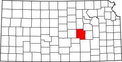
Location within Marion County
USA Kansas location map.svg
Red pog.svg
Fairplay Township
Marion County, Kansas
Location within the state of Kansas
Coordinates: 38°14′03″N96°59′23″W / 38.2340855°N 96.9898118°W / 38.2340855; -96.9898118 [1]
CountryUnited States
State Kansas
County Marion
Area
  Total
45 sq mi (120 km2)
Dimensions
  Length8.0 mi (12.9 km)
  Width6.0 mi (9.7 km)
Elevation
[1]
1,371 ft (418 m)
Population
 (2010) [2]
  Total
50
  Density1.1/sq mi (0.43/km2)
Time zone UTC-6 (CST)
  Summer (DST) UTC-5 (CDT)
Area code 620
FIPS code 20-22350 [1]
GNIS ID 477371 [1]
Website County website

Fairplay Township is a township in Marion County, Kansas, United States. [1] As of the 2010 census, the township population was 107, not including the city of Florence. [2]

Contents

Geography

Fairplay Township covers an area of 45 square miles (116.5 km2).

Communities

The township contains the following settlements:

Cemeteries

The township contains the following cemeteries:

Transportation

U.S. Route 50 and U.S. Route 77 pass through the township. [4]

References

  1. 1 2 3 4 5 "Fairplay Township, Marion County, Kansas", Geographic Names Information System , United States Geological Survey, United States Department of the Interior
  2. 1 2 "2010 Total Population - Township of Fairplay". U.S. Census Bureau. Archived from the original on February 12, 2020. Retrieved November 16, 2013.
  3. 1 2 Marion County Cemetery List. Archived May 9, 2013, at the Wayback Machine
  4. "Marion County Highway Map; KSDOT" (PDF). Archived from the original (PDF) on October 2, 2021. Retrieved November 16, 2013.

Further reading