In 1801 to 1802, Spain returned most of the land to France, keeping title to about 7,500 square miles. In 1803, most of the land for modern day Kansas was acquired by the United States from France as part of the 828,000 square mile Louisiana Purchase.
In 1864, the first settler in the Peabody area was W.C. Coble, from North Carolina, who set up ranch headquarters about 2+ miles east of the current city of Peabody (now section 36 of Catlin Township).[10] The first settlement made in the area was in September 1870, by a colony of settlers from Wisconsin. In October, more settlers arrived. During the first month, the colony officers laid out a town on the north-half of section 4 township 22 and surveyed it into lots. The town was named Coneburg after the town company president John Cone. The town site was located between the current 9th Street and Division Avenue. During the winter of 1870, some of the settlers returned east to get supplies and bring out their families. In 1871, while the other settlers were gone, dissatisfaction arose in the community and it began to break up. Claim jumping of the Coneburg town site and nearby land started to occur, thus causing a legal mess.[book 2]
In 1870, T.M. Potter homesteaded the south-half of the same section of land. In spring of 1871, he and five other men started the Peabody town company. Since the land title for the Peabody town site had no legal disputes, businesses immediately moved from Coneburg.[book 2] In June 1871, the town of Peabody was platted, and it included the land where the railroad was built on June 9.[11]
A post office was established in Coneburg on January 25, 1871 then moved to Peabody on October 30, 1871.[12]
In April 1872 during legal disputes, Coneburg became North Peabody. A revised plat of Peabody was made in July 1875 and a supplemental plat of North Peabody was made in April 1878. Because of the disputes, the street that ran down the middle of the border between the two towns was called "Division Avenue." The two towns merged into the city of Peabody in 1879.[book 2]
The town of Peabody was named in 1871 after F.H. Peabody, of Boston, formerly vice-president of the Atchison, Topeka and Santa Fe Railway company.[book 1][book 3] In May 1874, Mr. Peabody visited the new town, at which time he announced he would donate money for a library building, furniture, books, periodicals and landscaping if the Peabody township would secure four town lots for the site. The contract for construction was awarded in spring of 1875 and was opened to the public in June 1875, and the following February 1876 the state legislature authorized the township to levy a tax to support the library. The structure housed the library facilities until 1914 when a new Peabody Township Carnegie Library was constructed on the old location.[book 2][13]
In 1871, the Atchison, Topeka and Santa Fe Railway extended a main line from Emporia through Peabody to Newton.[14] In 1996 it merged with Burlington Northern Railroad and renamed to the current BNSF Railway. Most locals still refer to this railroad as the "Santa Fe". The first depot was built south of the tracks. Later a train wreck destroyed it and a second depot was built on the north side of the tracks.[10] In 1873, three westbound trains (9:05am, 1:00pm, 8:30pm) and three eastbound trains (4:42am, 6:50pm, 8:30pm) stopped at the Peabody depot.[15] Rail service was still very strong five decades later. In 1925, three westbound and four eastbound trains made stops at Peabody.[10] The second depot was demolished in the 1970s after passenger transportation ended, then its land was converted into the Santa Fe Park, which is located at the south end of Walnut Street. Currently Amtrak's Southwest Chief passenger train currently passes through Peabody twice each day, but stops at nearby Newton.
In 1875, Peabody held its first agricultural "county fair" and continued to hold them annually for many years.[21] In September 1885, the Kansas State Fair was held at Peabody during the first four days of the month. An outstanding feature of the state fair was "the First Monument to General Grant", who died shortly before the fair. The temporary monument was an obelisk about 40 feet (12m) tall, and built from forty bushels of ears of corn. The fair had a grandstand, which could hold 2000 people, to view horse races. The race track was used for a variety of events, including horse walking teams in harness, trotting, running, pacing, mule racing, and daily chariot races. A dining hall was built that was capable of feeding 10,000 people each day. In 1900, the Marion County Agricultural Society sold the fair grounds to the city, which renamed it the Peabody City Park, and its entrance is located at the corner of Locust and 2nd Streets.[10][22]
Peabody was the home of famous race horses around the turn of the century. Three of the more famous horses were world champions. Joe Young (known as the "iron horse") sold for $10,000 by C.E. Westbrook, the first horse west of the Mississippi River to sell for such a high price. Joe Young sired Joe Patchen in 1889,[23] who earned his owner $40,000 in race purses and then was sold for $44,000. Joe Patchen sired Dan Patch in 1896, a horse that sold in 1907 for $60,000. Other famous local racing horses included trotters McKinney, and Silver Sign. Silverthorne toured Austria where he competed for three years against the best race horses in Europe.[24][25]
20th century
1914 Peabody Township "Carnegie" Library (2010)1974 Mennonite Centennial Memorial Monument in Santa Fe Park A threshing stone was cut and placed on 4 sides of this monument. In the foreground is a brick street; streets in Peabody are typically brick (2010).Cross sections of a threshing stone on a Mennonite monument (2010)
Peabody became an important supply point for one of the state's cattle feeding districts. By 1911, approximately 20,000 head of cattle were imported from other states and fed within 20 miles (32km) of Peabody at 50 farms. Because of the cattle industry, local farmers grew more corn, alfalfa, and other feed crops during the 1900s and 1910s.[26]
Peabody and Watchorn areas experienced an oil boom from 1918 to 1920 in the oil fields of the Mid-Continent oil province. The influence of the petroleum industry remained strong in Peabody, and resulted in the greatest change upon the community in the shortest time. More than 100 residences were constructed in October and November 1919. From 1918 to 1919, the population increased by 75% or more, but later decreased as oil booms in other Kansas areas needed the workers. Currently Watchorn is a ghost town consisting of oil wells but no remaining historical structures.
The New Santa Fe Trail road was routed through Peabody in the late 1910s. The road entered the north-east side of the city on Old Mill Rd, and exited on the south-west side on 60th Street (known as the Old Trail).[27][28] The trail became U.S. Route 50 in the late 1930s when the new highway was routed east to west on 9th Street. In 1998, the highway was moved about 1.5 blocks north so it could go over a new railroad overpass.[29]
In 1943, German and Italian prisoners of World War II were brought to Kansas and other midwest states as a means of solving the labor shortage caused by American men serving in the war effort. Large prisoner-of-war camps camps were established in Kansas at Camp Concordia, Camp Funston (at Fort Riley), and Camp Phillips (at Salina under Fort Riley). Fort Riley established 12 smaller branch camps, including Peabody and El Dorado.[30][31] Up to 150 prisoners were quartered at the Peabody branch camp.[10] Farmers were to have first priority over other industries in requesting prisoner labor. County agents were responsible for processing the application of local residents seeking the use of the prisoners who were to be available only as group laborers. No fewer than four prisoners could be assigned to a farm, and a guard accompanied each group, but later it was common for no guards to accompany the prisoners. The prisoners were not allowed to operate any powered farm equipment. The farmer collected the workers at the camp and returned them at the end of each day. The Peabody branch camp #101 was located in the Eyestone building, now occupied by Heckendorn Equipment Company, and located at 122 West 2nd Street.[10] The prisoner yard was located in the north-east corner of the property and still exists as a storage area. The camp was closed in December 1945, after Germany surrendered.[10]
There have been numerous floods during the history of Peabody. In June and July 1951, due to heavy rains, rivers and streams flooded numerous cities in Kansas, including Peabody. Many reservoirs and levees were built in Kansas as part of a response to the Great Flood of 1951.
The community gradually increased in size as a commuter town to support aircraft industries in Wichita during World War II and Soviet UnionCold War years.[citation needed] Over time the aircraft industry worker requirement has shrank, thus has their influence on numerous commuter towns. Another gradual impact on the community has been the decrease in the size of farm families. Over time as farm equipment has increased in size, so has it decreased the number of family farms in the area, because fewer people are required to farm larger amounts of land.[citation needed] Fewer farms families has led to a gradual decrease in children at local schools. Peabody, like most rural towns, has seen a gradual loss of population due to rural flight to larger cities.
The community has long had great pride in celebrating and promoting its past. Three centennials, the Kansas centennial in 1961, the Peabody centennial in 1971, and the United States Bicentennial in 1976 caused surges of historic pride. It led to the creation of the Peabody Main Street Association (PMSA) in 1989 and the Peabody Community Foundation (PCF).[32] The Peabody Main Street Association has won numerous awards since it was founded.[33]
Truck hauling 36-Inch pipe to build Keystone-Cushing Pipeline (Phase II) south-east of Peabody at corner of Timber Rd and 20th St in Marion County. (Whitewater Center Church in background) (2010)
In 2010, the Peabody Main Street Association received 5 state awards.[33] In the same year, the Keystone-Cushing Pipeline (Phase II) was constructed 4.5 miles (7.2km) east of Peabody, north to south through Marion County. There was quite a bit of controversy over road damage, tax exemption, and environmental concerns (if a leak ever occurs).[34][35][36]
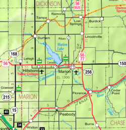
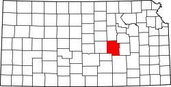
According to the United States Census Bureau, the city has a total area of 1.34 square miles (3.47km2), all land[38] except Doyle Creek and Spring Creek. It is approximately 15mi (24km) north-east of Newton, 42mi (68km) north of Wichita, 164mi (264km) south-west of Kansas City. The north-eastern corner of Harvey County is 2.0 miles (3.2km) west of Peabody.
Climate
On average in Peabody, January is the coolest month with an average low of 19°F (-7°C), July is the warmest month with an average high of 92°F (33°C), and May is the wettest month with an average precipitation of 4.64 in. The hottest temperature recorded in Peabody was 115°F (43°C) in 1954; the coldest temperature recorded was -22°F (-31°C) in 1989.[39]
Of the 397 households, 24.7% had children under the age of 18; 42.8% were married couples living together; 31.5% had a female householder with no spouse or partner present. 35.0% of households consisted of individuals and 18.6% had someone living alone who was 65 years of age or older.[41] The average household size was 2.4 and the average family size was 3.0.[45] The percent of those with a bachelor’s degree or higher was estimated to be 10.9% of the population.[46]
20.1% of the population was under the age of 18, 5.7% from 18 to 24, 19.2% from 25 to 44, 30.8% from 45 to 64, and 24.2% who were 65 years of age or older. The median age was 48.8 years. For every 100 females, there were 103.7 males.[41] For every 100 females ages 18 and older, there were 108.6 males.[41]
The 2016-2020 5-year American Community Survey estimates show that the median household income was $43,924 (with a margin of error of +/- $2,762) and the median family income was $47,500 (+/- $2,725).[47] Males had a median income of $23,611 (+/- $10,367) versus $25,227 (+/- $14,309) for females. The median income for those above 16 years old was $23,750 (+/- $6,810).[48] Approximately, 3.0% of families and 12.5% of the population were below the poverty line, including 2.9% of those under the age of 18 and 16.6% of those ages 65 or over.[49][50]
2010 census
As of the census[51] of 2010, there were 1,210 people, 478 households, and 299 families residing in the city. The population density was 903.0 inhabitants per square mile (348.7/km2). There were 566 housing units at an average density of 422.4 per square mile (163.1/km2). The racial makeup of the city was 93.2% White, 1.6% African American, 1.2% Native American, 0.2% Asian, 0.1% Pacific Islander, 0.8% from other races, and 2.8% from two or more races. Hispanic or Latino of any race were 3.3% of the population.
There were 478 households, of which 27.8% had children under the age of 18 living with them, 50.4% were married couples living together, 7.7% had a female householder with no husband present, 4.4% had a male householder with no wife present, and 37.4% were non-families. 32.8% of all households were made up of individuals, and 15.3% had someone living alone who was 65 years of age or older. The average household size was 2.33 and the average family size was 2.94.
The median age in the city was 45.8 years. 22.2% of residents were under the age of 18; 6.2% were between the ages of 18 and 24; 20.1% were from 25 to 44; 29.5% were from 45 to 64; and 21.8% were 65 years of age or older. The gender makeup of the city was 50.3% male and 49.7% female.
Economy
The largest employer in Peabody is Peabody–Burns USD 398, which has two schools in the city.
Arts and culture
Area events
July 4 Celebration,[52][53][54] 100th annual in 2021, fireworks are displayed in the historic Peabody City Park (near Locust and 2nd streets)[22] The fireworks are famous for the display at the end which is called the Battle of New Orleans; over a million individual items are expoded in the display.[55] In the 1960s and 1970s, up to 30,000 or more people attended the event, including a carnival of rides.[7][56]
Doyle Valley Farmers Market,[57] Santa Fe Park (near Walnut and 1st streets), Memorial Day to Labor Day, 8am to noon
Area attractions
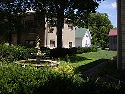
Fountain next to W.H. Morgan House (immediate right), W.H. Morgan Barn (back right with red roof), Carnegie Library (left with brown brick), and museum (back middle with green roof) Looking north-east (2010)
1880s Peabody Downtown Historic District (NRHP).[58] The Downtown Business District of Peabody boasts of 42 contributing buildings in the district. The significant period for the district began in 1874 with the construction of the first free public library and ended in 1922 with the decline in oil production. Peabody is the second community in the State of Kansas to have its entire downtown district on the National Register of Historic Places.[59]
1884 J.S. Schroeder Building (NRHP),[60] 111 North Walnut Street. Many types of businesses were on the first floor, but most older locals remember it as the McMillen grocery store. For the past couple of decades, the first floor has been occupied by the Mayesville Mercantile.
1919 Eyestone building, previously a POW camp during World War II, 122 West 2nd Street, private business.[10]
Peabody Museum Historical Complex,[62] Memorial Day to Labor Day.
1874 Peabody Historical Library Museum (NRHP),[13] 106 East Division Avenue (east of Carnegie Library). After the new Carnegie library was built in 1914, the first library was moved and used for club meetings and stood idle for a number of years. In 1960, while planning for the 1961 Kansas centennial celebration, local citizens organized to move the structure to a lot near its original location. The old library building was converted and dedicated as a museum on July 3, 1961.
1881 W.H. Morgan House (NRHP),[63] 212 North Walnut Street. A two-story Queen Anne Cottage built by W.H. Morgan, first editor of the Peabody Gazette newspaper.[59][64]
1904 W.H. Morgan Barn, east of House. Will contain larger items that can't fit in the museum, not yet open to public.[needs update?]
1920 Peabody Printing Museum,[65] 210 North Walnut Street. The Peabody Printing Museum has a collection of hot type equipment dating from 1870 to 1920.
1881 Fair Floral Exhibition Hall,[56] west of the football field at the top of the hill in the park. The building is unique because of its octagon walls. It is the only remaining fair building and not open to the public.[22]
1887 T.B. Townsend Barn, several miles east near U.S. Route 50. It is a three-story, 80 feet by 140 feet, limestone barn, and can easily be seen on the north side of the highway, not open to public.[66][67][68][book 4]
1927 Indian Guide Monument,[10] several miles east near U.S. Route 50. Can be seen from a bluff overlooking the south side of the highway, not open to public.
1974 Mennonite Centennial Memorial Monument, south-east corner of Walnut and 1st Streets in the Santa Fe Park. A threshing stone was cut and placed on four sides of this monument.[17]
Marion Reservoir, approximately 13 miles (21km) north of Peabody.
Government
The Peabody government consists of a mayor and five council members. The council meets twice a month.[3][2]
City Hall, 300 North Walnut Street
Fire Department, 103 North Sycamore Street
Police Department and City Shop, 107 East 9th Street.
Peabody-Burns Junior/Senior High School (looking north-east in 2010)Football Stadium at Peabody City Park (looking south-west in 2010) The limestone bleachers as well as the west and north walls were built in 1938 by the WPA in addition to other park items.
Primary and secondary
The community is served by Peabody–Burns USD 398 public school district. The school district includes Peabody, Burns, Wonsevu, and nearby rural areas of Marion / Chase / Harvey / Butler Counties. There are two schools in the district in Peabody:
The high school band is well known in regional competitions and parades.[citation needed] The high school is a member of T.E.E.N., a shared video teaching network which was started in 1993, between five area high schools.[71]
Sports
The Peabody-Burns High School mascot is the Warrior. All high school athletic and non-athletic competition is overseen by the Kansas State High School Activities Association. For the 2010/2011 seasons, the football team competes as Class 8 Man - Division I in the Wheat State league.[72]
1963, 1st Place, Class B, High School Boys Basketball, head coach Cal Reimer[76][77]
History
The first school in Peabody was organized in 1871. The first school building, two stone rooms, was built in 1872. The first high school classes were taught in 1879, and the first graduation class in 1881 consisted of 2 students.[10] In 1923, a new high school was built at 900 North Walnut Street.[10] In 1946–1947, the School Reorganization Act consolidated many one-room rural schools into the Peabody school district.[10] In 1953, the Brown Building was built to house a larger gymnasium, band / lunch room, and vocational agriculture rooms.[10] In 1965, the Burns and Summit school districts were unified with Peabody to form Unified School District 398.[10] The Summit school and Burns High School were closed. In 1996–1997, the current high school was built (and attached) to the south side the existing Brown Building at 810 North Sycamore Street. Soon afterward, the former 1923 high school across the street was demolished and converted into a football practice field. The Burns Grade School, which included a junior high, was closed.[10] Currently all students in USD 398 attend schools in Peabody.
Library
Each USD 398 school has a library for student access.
The city is served by the Peabody Township Carnegie Library at 214 North Walnut Street. The library was established in 1874, a Carnegie library since 1914, was the first free tax-supported library in Kansas.[13][61] As of 2018, the library has a 50 Mbps fiber optic internet connection; patrons are able to access it with five library computers or free Wi-Fi access using their own device. The library is a member of the North Central Kansas Libraries System, which provides an inter-library book loan service from across the State of Kansas. The library is home to the 1919 "Peabody Roll of Honor" painting that depicts the names of all men from the Peabody Township who served in World War I.[78] It also has a significant meeting room downstairs with a kitchen and is handicap accessible.
Small Town, USA, a feature documentary[81] which is currently in pre-production,[82] examines the challenges faced by communities, employers, and individuals as they work to develop cultural and economic models that will ensure survival. IMG Pictures filmed in many small towns in rural Kansas, including Peabody.[83] The Peabody downtown is being used for the promotional picture.[84]
Infrastructure
Transportation
Rails
Currently two railroads pass through Peabody, BNSF Railway and Union Pacific Railroad. The two railroads cross each other as a Level junction in southwest Peabody, and a rarely used connection between the two railroads allows eastbound BNSF trains to turn onto the northbound Union Pacific railroad.
The BNSF Railway (previously Santa Fe) runs east–west through the city and has a spur for grain cars at the east Mid Kansas Co-Op.[85] Its former depot was located on the north side of the tracks on the east side of Walnut and south of 1st Street was demolished in the 1970s, then its land was converted into the Santa Fe Park.[10] Currently, two AmtrakSouthwest Chief passenger trains (east bound & west bound) pass through Peabody during late night hours, but stops at the depot in Newton.[86]
The Oklahoma Kansas Texas (OKT)[87] line of the Union Pacific Railroad (previously Rock Island) runs north–south through the city and has a spur for grain cars at the west Mid Kansas Co-Op.[88] The Kansas City Rocket provided passenger rail service through Peabody on their Mid-Continent Route until at least 1963.[89] Its former depot was located on the east side of the tracks between 1st and 2nd street was demolished in the early 1960s.[10]
Roads
Currently U.S. Highway 50 passes through the northern edge of the city and follows roughly parallel to the BNSF Railway.[90]
In the early years of the highway before U.S. Route 50 was finalized in the 1930s, the highway was known as the New Santa Fe Trail, which entered the north side of the city on Newell Road (later on Old Mill Road), and exited on the south-western side on 60th Street (known as the Old Trail).[27][28] In fall 1933, an underpass on 9th street (50S) was constructed to go under the Rock Island Railroad as part of the New Deal highway program during the Great Depression.[91][92] Until the late 1950s, U.S. Route 50 was split into two routes through central Kansas. The routes were called 50N and 50S, and the highway through Peabody was 50S. From the 1930s to 1998, the highway was routed east to west through Peabody on 9th Street, then a bypass and overpass were built approximately 1.5 blocks north to avoid a dangerous underpass which went under the Union Pacific Railroad.[29]
C. M. Arbuthnot (1852–1920), physician, founder of Arbuthnot Drug Company, Principal at public school in Peabody for two years.[96][97]
Warren Bechtel (1872–1933), founder of Bechtel engineering and construction company, graduated from Peabody High School in 1891. In 1925, Warren, his three sons, and his brother Arthur (from Peabody) joined together to form the W.A. Bechtel Company, then later became Bechtel Corporation (second largest construction company in USA, as of 2022) (eighth largest private company in USA by revenue, as of 2017).
George Fox (1880-1963), amateur archaeologist, historian, curator, author; was born in Peabody.
Dennis Franchione (born 1951), head football coach at various colleges, last at Texas State University. Head football coach of Peabody High School from 1976 to 1977 of which his fall 1977 football team placed 2nd in 2A state playoffs.[100]
Frederic Remington (1861–1909), American Old West artist, sheep rancher.[10][102] Many texts describe the location of his ranch near Peabody. In actuality, it was closer to Plum Grove, which didn't have a railroad. He spent free time in both communities.
Light Up The Sky: Peabody at 150: 1871-2021; Donald E. Skinner; Mennonite Press; 375 pages; 2021; LCCN 2021906326.
The Women of Peabody; Peabody Historical Society; Mennonite Press; 250 pages; 2010; LCCN 2010928692.
The Germans We Trusted: Stories Which Had To Be Told...; Pamela Taylor; Lutterworth Press; 192 pages; 2003; ISBN978-0-7188-3034-2. (World War II POW camp history)
History of the Peabody United Methodist Church, 125 Years, 1871–1996; Kris Carswell and Muriel Wolfersperger.
Townsend Ranch History, 1870–1987; Carl F. and Helen Hansen; 1990.
This page is based on this Wikipedia article Text is available under the CC BY-SA 4.0 license; additional terms may apply. Images, videos and audio are available under their respective licenses.


