National Register of Historic Places listings in Chase County, Kansas

Last updated

Location of Chase County in Kansas Map of Kansas highlighting Chase County.svg
Location of Chase County in Kansas

This is a list of the National Register of Historic Places listings in Chase County, Kansas.

Contents

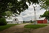
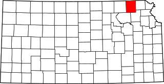
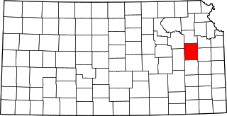
This is intended to be a complete list of the properties and districts on the National Register of Historic Places in Chase County, Kansas, United States. The locations of National Register properties and districts for which the latitude and longitude coordinates are included below, may be seen in a map. [1]

There are 19 properties and districts listed on the National Register in the county.


    This National Park Service list is complete through NPS recent listings posted May 20, 2022. [2]

Map all coordinates using: OpenStreetMap  
Download coordinates as: KML

Current listings

[3] Name on the Register [4] ImageDate listed [5] Location City or townDescription
1 Cartter Building
Cartter Building Cartter Building.JPG
Cartter Building
November 23, 1977
(#77000573)
303 Broadway
38°22′19″N96°32′30″W / 38.371944°N 96.541667°W / 38.371944; -96.541667 (Cartter Building)
Cottonwood Falls Built in 1888 for Dr. William H. Cartter, the ground floor contained the Smith and Cartter grocery store.
2 Cedar Point Mill
Cedar Point Mill Cedar Point Mill, Cedar Point Kansas.JPG
Cedar Point Mill
December 20, 2006
(#06001166)
Junction of Main and 1st Sts.
38°15′42″N96°49′10″W / 38.261667°N 96.819444°W / 38.261667; -96.819444 (Cedar Point Mill)
Cedar Point Built from 1871 to 1875, replacing a wooden structure.
3 Chase County Courthouse
Chase County Courthouse ChaseCounty(KS)Courthouse.JPG
Chase County Courthouse
February 24, 1971
(#71000304)
On the square at the southern end of Broadway
38°22′21″N96°32′30″W / 38.3725°N 96.541667°W / 38.3725; -96.541667 (Chase County Courthouse)
Cottonwood Falls Built in 1873, it is the oldest operating courthouse in Kansas.
4 Chase County National Bank
Chase County National Bank Chase County National Bank.JPG
Chase County National Bank
November 9, 1977
(#77000572)
301 Broadway
38°22′19″N96°32′30″W / 38.371944°N 96.541667°W / 38.371944; -96.541667 (Chase County National Bank)
Cottonwood Falls Built in 1882 from nearby limestone.
5 Clements Stone Arch Bridge
Clements Stone Arch Bridge US-KS-ClementsStoneArchBridge-001.jpg
Clements Stone Arch Bridge
December 12, 1976
(#76000816)
½ mile southeast of Clements over the Cottonwood River
38°17′42″N96°44′05″W / 38.295°N 96.734722°W / 38.295; -96.734722 (Clements Stone Arch Bridge)
Clements Built between 1886 and 1888.
6 Clover Cliff Ranch House
Clover Cliff Ranch House Clover Cliff Ranch House.JPG
Clover Cliff Ranch House
November 9, 1977
(#77000574)
4 miles southwest of Elmdale off U.S. Route 50
38°19′55″N96°41′47″W / 38.331944°N 96.696389°W / 38.331944; -96.696389 (Clover Cliff Ranch House)
Elmdale 
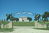
In 1867, J.R. Blackshere returned to Chase County, Kansas with his wife and four children to make his home on what would become the Clover Cliff Ranch. The stone house was completed by 1883.
7 Cottonwood Falls Grade School
Cottonwood Falls Grade School Cottonwood Falls Grade School Kansas front view.jpg
Cottonwood Falls Grade School
June 28, 2021
(#100006682)
401 Maple St.
38°21′57″N96°32′37″W / 38.3659°N 96.5435°W / 38.3659; -96.5435 (Cottonwood Falls Grade School)
Cottonwood Falls
8 Cottonwood River Bridge
Cottonwood River Bridge Cottonwood River Bridge.JPG
Cottonwood River Bridge
July 2, 1985
(#85001422)
K-177, northern edge of Cottonwood Falls
38°22′30″N96°32′26″W / 38.375°N 96.540556°W / 38.375; -96.540556 (Cottonwood River Bridge)
Cottonwood Falls Built in 1914 by the Missouri Valley Bridge Company of Leavenworth, Kansas.
9 Cottonwood River Pratt Truss Bridge
Cottonwood River Pratt Truss Bridge Cottonwood River Pratt Truss Bridge.JPG
Cottonwood River Pratt Truss Bridge
May 9, 2003
(#03000376)
Main St., 0.8 miles west of intersection with 1st St.
38°15′36″N96°50′02″W / 38.26°N 96.833889°W / 38.26; -96.833889 (Cottonwood River Pratt Truss Bridge)
Cedar Point Built in 1916, the Pratt Truss Bridge has a single span that measures 142 feet in length and 17 feet in width.
10 Crocker Ranch
Crocker Ranch Crocker Ranch.JPG
Crocker Ranch
November 17, 1977
(#77000575)
1.5 miles north of Matfield Green on K-177
38°10′55″N96°34′05″W / 38.181944°N 96.568056°W / 38.181944; -96.568056 (Crocker Ranch)
Matfield Green The Crocker Ranch, with its extensive cattle and farming operations, was begun in 1866 by Captain Erastus Bryant Crocker, a Civil War veteran. The house and various buildings were built by Erastus Crocker's son Edward Grey Crocker in the 1880s.
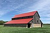
11 Fox Creek Stone Arch Bridge
Fox Creek Stone Arch Bridge Fox Creek Stone Arch Bridge.JPG
Fox Creek Stone Arch Bridge
December 27, 2006
(#06001164)
½ mile north and ¾ mile west of junction of U.S. Route 50 and Cottonwood St.
38°24′08″N96°32′54″W / 38.402222°N 96.548333°W / 38.402222; -96.548333 (Fox Creek Stone Arch Bridge)
Strong City Construction of the native limestone bridge was begun in 1897 and completed in 1898.
12 Lower Fox Creek School
Lower Fox Creek School Lower Fox Creek School 04.JPG
Lower Fox Creek School
September 6, 1974
(#74000822)
Northwest of Strong City on K-177
38°26′43″N96°33′30″W / 38.445278°N 96.558333°W / 38.445278; -96.558333 (Lower Fox Creek School)
Strong City Stephen F. Jones donated the land and a local stonemason built the schoolhouse in 1882 with limestone from nearby quarries.
13 McNee Barns
McNee Barns McNee Barns horse barn Chase County Kansas.jpg
McNee Barns
June 25, 2013
(#13000431)
3 miles southwest of Elmdale on U.S. Highway 50 (SS T20S R7E)
38°20′15″N96°40′47″W / 38.33760°N 96.6798°W / 38.33760; -96.6798 (McNee Barns)
Elmdale The structures include: a circa 1920 horse barn, a 1948 boxcar barn, a dry-laid stone fence, and an Aermotor windmill.
14 Pioneer Bluffs Ranch Historic District
Pioneer Bluffs Ranch Historic District Pioneer Bluffs Historic District.jpg
Pioneer Bluffs Ranch Historic District
September 13, 1990
(#90001441)
K-177 1 mile north of Matfield Green
38°10′33″N96°33′50″W / 38.175833°N 96.563889°W / 38.175833; -96.563889 (Pioneer Bluffs Ranch Historic District)
Matfield Green The ranch is part of the 160 acres (65 ha) farm, settled by Charles Rogler in 1859. The original log cabin does not exist, but the now standing old house and old barn were constructed in 1872.
15 William C. & Jane Shaft House
William C. & Jane Shaft House William C. & Jane Shaft House Chase County Kansas front view.jpg
William C. & Jane Shaft House
July 8, 2010
(#10000449)
1682 FP Rd.
38°18′53″N96°43′58″W / 38.314722°N 96.732778°W / 38.314722; -96.732778 (William C. & Jane Shaft House)
Clements The land was settled by William and Jane Shaft in 1854. In 1857, a small stone house was built; and, in 1868, the two story limestone house was added to the south side of the original structure. Jane Shaft's name is inscribed within the east facing gable.
16 Spring Hill Farm and Stock Ranch House
Spring Hill Farm and Stock Ranch House SPRING HILL FARM AND STOCK RANCH HOUSE.jpg
Spring Hill Farm and Stock Ranch House
April 16, 1971
(#71000305)
3 miles north of Strong City on K-177
38°26′03″N96°33′27″W / 38.434167°N 96.5575°W / 38.434167; -96.5575 (Spring Hill Farm and Stock Ranch House)
Strong City Now part of Tallgrass Prairie National Preserve
17 Strong City Atchison, Topeka, & Santa Fe Depot
Strong City Atchison, Topeka, & Santa Fe Depot StrongCityDepot.JPG
Strong City Atchison, Topeka, & Santa Fe Depot
June 27, 2007
(#07000607)
102 W. Topeka Ave.
38°23′42″N96°32′24″W / 38.395°N 96.54°W / 38.395; -96.54 (Strong City Atchison, Topeka, & Santa Fe Depot)
Strong City Built in 1913 at a cost of $20,000, the Atchison, Topeka, and Santa Fe Railroad Depot operated until 1938. It included two passenger waiting rooms, a ticket office, telegraph desk, main office, and baggage room. The depot's west end was the freight office.
18 Whitney Ranch Historic District
Whitney Ranch Historic District Whitney Ranch Chase Co KS Main House front view.jpg
Whitney Ranch Historic District
May 11, 1995
(#95000589)
Southeast of Hymer off unnamed road
38°28′46″N96°40′45″W / 38.479444°N 96.679167°W / 38.479444; -96.679167 (Whitney Ranch Historic District)
Hymer
19 Wood House
Wood House Wood House (Cottonwood Falls).JPG
Wood House
March 17, 1974
(#74000821)
East of Cottonwood Falls
38°22′14″N96°31′10″W / 38.370556°N 96.519444°W / 38.370556; -96.519444 (Wood House)
Cottonwood Falls

See also

Related Research Articles

National Register of Historic Places listings in Doniphan County, Kansas

This is a list of the National Register of Historic Places listings in Doniphan County, Kansas.

National Register of Historic Places listings in Harvey County, Kansas

This is a list of the National Register of Historic Places listings in Harvey County, Kansas.

National Register of Historic Places listings in Douglas County, Kansas

This is a list of the National Register of Historic Places listings in Douglas County, Kansas.

National Register of Historic Places listings in Riley County, Kansas

This is a list of the National Register of Historic Places listings in Riley County, Kansas.

National Register of Historic Places listings in Morris County, Kansas

This is a list of the National Register of Historic Places listings in Morris County, Kansas.

National Register of Historic Places listings in Sedgwick County, Kansas

This is a list of the National Register of Historic Places listings in Sedgwick County, Kansas.

National Register of Historic Places listings in Franklin County, Kansas

This is a list of the National Register of Historic Places listings in Franklin County, Kansas.

National Register of Historic Places listings in Johnson County, Kansas

This is a list of the National Register of Historic Places listings in Johnson County, Kansas.

National Register of Historic Places listings in Reno County, Kansas

This is a list of the National Register of Historic Places listings in Reno County, Kansas.

National Register of Historic Places listings in Saline County, Kansas

This is a list of the National Register of Historic Places listings in Saline County, Kansas.

National Register of Historic Places listings in Crawford County, Kansas

This is a list of the National Register of Historic Places listings in Crawford County, Kansas.

National Register of Historic Places listings in Labette County, Kansas

This is a list of the National Register of Historic Places listings in Labette County, Kansas.

National Register of Historic Places listings in Bourbon County, Kansas

This is a list of the National Register of Historic Places listings in Bourbon County, Kansas.

National Register of Historic Places listings in Cloud County, Kansas

This is a list of the National Register of Historic Places listings in Cloud County, Kansas.

National Register of Historic Places listings in Miami County, Kansas

This is a list of the National Register of Historic Places listings in Miami County, Kansas.

National Register of Historic Places listings in Mitchell County, Kansas

This is a list of the National Register of Historic Places listings in Mitchell County, Kansas.

National Register of Historic Places listings in Finney County, Kansas

This is a list of the National Register of Historic Places listings in Finney County, Kansas.

National Register of Historic Places listings in Cherokee County, Kansas

This is a list of the National Register of Historic Places listings in Cherokee County, Kansas.

National Register of Historic Places listings in Republic County, Kansas

This is a list of the National Register of Historic Places listings in Republic County, Kansas.

National Register of Historic Places listings in Jackson County, Missouri

This is a list of the National Register of Historic Places listings in Jackson County, Missouri.

References

  1. The latitude and longitude information provided in this table was derived originally from the National Register Information System, which has been found to be fairly accurate for about 99% of listings. Some locations in this table may have been corrected to current GPS standards.
  2. National Park Service, United States Department of the Interior, "National Register of Historic Places: Weekly List Actions", retrieved May 20, 2022.
  3. Numbers represent an alphabetical ordering by significant words. Various colorings, defined here, differentiate National Historic Landmarks and historic districts from other NRHP buildings, structures, sites or objects.
  4. "National Register Information System". National Register of Historic Places . National Park Service. March 13, 2009.
  5. The eight-digit number below each date is the number assigned to each location in the National Register Information System database, which can be viewed by clicking the number.