National Register of Historic Places listings in Osborne County, Kansas

Last updated

Location of Osborne County in Kansas Map of Kansas highlighting Osborne County.svg
Location of Osborne County in Kansas

This is a list of the National Register of Historic Places listings in Osborne County, Kansas.

Contents

This is intended to be a complete list of the properties on the National Register of Historic Places in Osborne County, Kansas, United States. The locations of National Register properties for which the latitude and longitude coordinates are included below, may be seen in a map. [1]

There are 7 properties listed on the National Register in the county.


    This National Park Service list is complete through NPS recent listings posted August 18, 2023. [2]

Map all coordinates using: OpenStreetMap

Current listings

[3] Name on the Register [4] ImageDate listed [5] Location City or townDescription
1 Downs Carnegie Library
Downs Carnegie Library Downs, Kansas Carnegie library from E 1.JPG
Downs Carnegie Library
June 25, 1987
(#87000966)
504 Morgan [6]
39°30′01″N98°32′41″W / 39.500291°N 98.544829°W / 39.500291; -98.544829 (Downs Carnegie Library)
Downs
2 Downs Missouri Pacific Depot
Downs Missouri Pacific Depot Downs, Kansas MoPac station from SW 1.JPG
Downs Missouri Pacific Depot
October 11, 2001
(#01001093)
710 Railroad St.
39°30′09″N98°32′36″W / 39.502582°N 98.543375°W / 39.502582; -98.543375 (Downs Missouri Pacific Depot)
Downs
3 East Fork Wolf Creek Pratt Truss Bridge
East Fork Wolf Creek Pratt Truss Bridge E Fork Wolf Creek bridge, 290 Dr, from SW 2.jpg
East Fork Wolf Creek Pratt Truss Bridge
May 9, 2003
(#03000361)
W 290th Dr., 0.8 miles (1.3 km) east of its junction with S. 50th Ave., 2 miles (3.2 km) south and 4 miles (6.4 km) east of Cheyenne
39°08′52″N98°34′07″W / 39.147815°N 98.568488°W / 39.147815; -98.568488 (East Fork Wolf Creek Pratt Truss Bridge)
Delhi
4 Geodetic Center of the United States
Geodetic Center of the United States North America geodetic center - replica plaque 1.JPG
Geodetic Center of the United States
October 9, 1973
(#73000772)
17 miles (27 km) southeast of Osborne off U.S. Route 281 on Meade's Ranch
39°13′27″N98°32′31″W / 39.224167°N 98.541944°W / 39.224167; -98.541944 (Geodetic Center of the United States)
Osborne
5 Natoma Presbyterian Church
Natoma Presbyterian Church Presbyterian Church (Natoma KS) from SW 2.JPG
Natoma Presbyterian Church
November 21, 2006
(#06001052)
408 N. 3rd St.
39°11′24″N99°01′17″W / 39.1899°N 99.021479°W / 39.1899; -99.021479 (Natoma Presbyterian Church)
Natoma
6 Osborne County Courthouse
Osborne County Courthouse Osborne County Courthouse, Osborne, KS.JPG
Osborne County Courthouse
April 26, 2002
(#02000392)
423 W. Main St.
39°26′16″N98°42′04″W / 39.437778°N 98.701111°W / 39.437778; -98.701111 (Osborne County Courthouse)
Osborne
7 Osborne Public Carnegie Library
Osborne Public Carnegie Library Osborne, Kansas Carnegie library from NE 1.JPG
Osborne Public Carnegie Library
June 25, 1987
(#87000967)
307 W. Main [7]
39°26′16″N98°41′56″W / 39.437883°N 98.69893°W / 39.437883; -98.69893 (Osborne Public Carnegie Library)
Osborne Now operated by the Osborne County Genealogical and Historical Society [8]

Former listings

[3] Name on the RegisterImageDate listedDate removedLocationCity or townDescription
1 IOOF Lodge May 16, 2002
(#02000491)
February 24, 2012Junction of Nicholas and Mill Sts.
39°27′21″N98°56′53″W / 39.455833°N 98.948056°W / 39.455833; -98.948056 (IOOF Lodge)
Alton Collapsed on April 11, 2010.

See also

Related Research Articles

<span class="mw-page-title-main">National Register of Historic Places listings in Doniphan County, Kansas</span>

This is a list of the National Register of Historic Places listings in Doniphan County, Kansas.

<span class="mw-page-title-main">National Register of Historic Places listings in Harvey County, Kansas</span>

This is a list of the National Register of Historic Places listings in Harvey County, Kansas.

<span class="mw-page-title-main">National Register of Historic Places listings in Douglas County, Kansas</span>

This is a list of the National Register of Historic Places listings in Douglas County, Kansas.

<span class="mw-page-title-main">National Register of Historic Places listings in Morris County, Kansas</span>

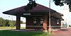
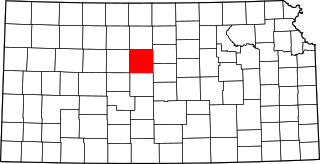
This is a list of the National Register of Historic Places listings in Morris County, Kansas.

<span class="mw-page-title-main">National Register of Historic Places listings in Sedgwick County, Kansas</span>

This is a list of the National Register of Historic Places listings in Sedgwick County, Kansas.

<span class="mw-page-title-main">National Register of Historic Places listings in Barton County, Kansas</span>

This is a list of the National Register of Historic Places listings in Barton County, Kansas.

<span class="mw-page-title-main">National Register of Historic Places listings in Johnson County, Kansas</span>

This is a list of the National Register of Historic Places listings in Johnson County, Kansas.

<span class="mw-page-title-main">National Register of Historic Places listings in Russell County, Kansas</span>

This is a list of the National Register of Historic Places listings in Russell County, Kansas.

<span class="mw-page-title-main">National Register of Historic Places listings in Nemaha County, Kansas</span>

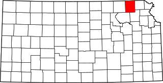
This is a list of the National Register of Historic Places listings in Nemaha County, Kansas.

<span class="mw-page-title-main">National Register of Historic Places listings in Butler County, Kansas</span>

This is a list of the National Register of Historic Places listings in Butler County, Kansas.

<span class="mw-page-title-main">National Register of Historic Places listings in Labette County, Kansas</span>

This is a list of the National Register of Historic Places listings in Labette County, Kansas.

<span class="mw-page-title-main">National Register of Historic Places listings in Cloud County, Kansas</span>

This is a list of the National Register of Historic Places listings in Cloud County, Kansas.

<span class="mw-page-title-main">National Register of Historic Places listings in Lincoln County, Kansas</span>

This is a list of the National Register of Historic Places listings in Lincoln County, Kansas.

<span class="mw-page-title-main">National Register of Historic Places listings in Greenwood County, Kansas</span>

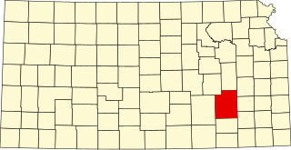
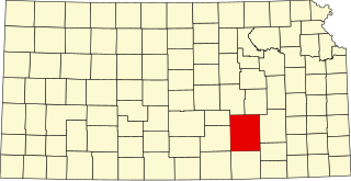
This is a list of the National Register of Historic Places listings in Greenwood County, Kansas.

<span class="mw-page-title-main">National Register of Historic Places listings in Grant County, South Dakota</span>

This is a list of the National Register of Historic Places listings in Grant County, South Dakota.

<span class="mw-page-title-main">National Register of Historic Places listings in Robeson County, North Carolina</span>

This list includes properties and districts listed on the National Register of Historic Places in Robeson County, North Carolina. Click the "Map of all coordinates" link to the right to view a Google map of all properties and districts with latitude and longitude coordinates in the table below.

<span class="mw-page-title-main">National Register of Historic Places listings in Mitchell County, Kansas</span>

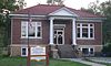
This is a list of the National Register of Historic Places listings in Mitchell County, Kansas.

<span class="mw-page-title-main">National Register of Historic Places listings in Finney County, Kansas</span>

This is a list of the National Register of Historic Places listings in Finney County, Kansas.

<span class="mw-page-title-main">National Register of Historic Places listings in Ford County, Kansas</span>

This is a list of the National Register of Historic Places listings in Ford County, Kansas.

<span class="mw-page-title-main">National Register of Historic Places listings in Rochester, New York</span>

This is intended to be a complete list of properties and districts listed on the National Register of Historic Places in Rochester, New York, United States. The locations of National Register properties and districts may be seen in an online map by clicking on "Map of all coordinates".

References

  1. The latitude and longitude information provided in this table was derived originally from the National Register Information System, which has been found to be fairly accurate for about 99% of listings. Some locations in this table may have been corrected to current GPS standards.
  2. National Park Service, United States Department of the Interior, "National Register of Historic Places: Weekly List Actions", retrieved August 18, 2023.
  3. 1 2 Numbers represent an alphabetical ordering by significant words. Various colorings, defined here, differentiate National Historic Landmarks and historic districts from other NRHP buildings, structures, sites or objects.
  4. "National Register Information System". National Register of Historic Places . National Park Service. March 13, 2009.
  5. The eight-digit number below each date is the number assigned to each location in the National Register Information System database, which can be viewed by clicking the number.
  6. "Library Locations". Solomon Valley Highway 24 Heritage Alliance. Retrieved 2014-11-04.
  7. See address in photo
  8. See photo showing sign