National Register of Historic Places listings in Reno County, Kansas

Last updated

Location of Reno County in Kansas Map of Kansas highlighting Reno County.svg
Location of Reno County in Kansas

This is a list of the National Register of Historic Places listings in Reno County, Kansas.

Contents

This is intended to be a complete list of the properties and districts on the National Register of Historic Places in Reno County, Kansas, United States. The locations of National Register properties and districts for which the latitude and longitude coordinates are included below, may be seen in a map. [1]

There are 20 properties and districts listed on the National Register in the county, and two former listings.


    This National Park Service list is complete through NPS recent listings posted July 28, 2023. [2]

Map all coordinates using: OpenStreetMap

Current listings

[3] Name on the Register [4] ImageDate listed [5] Location City or townDescription
1 Downtown Core North Historic District
Downtown Core North Historic District Downtown Core North Historic District, Hutchinson, Kansas.jpg
Downtown Core North Historic District
November 18, 2004
(#04000739)
Generally bounded by BNSF Railway tracks, 1st Ave., west side of N. Main and Poplar St.
38°03′22″N97°55′50″W / 38.056111°N 97.930556°W / 38.056111; -97.930556 (Downtown Core North Historic District)
Hutchinson Commercial and Industrial Resources of Hutchinson MPS
2 Downtown Core South Historic District
Downtown Core South Historic District Downtown Core South Historic District, Hutchinson, Kansas.jpg
Downtown Core South Historic District
November 18, 2004
(#04000737)
Generally bounded by C Ave., the alley south of Sherman, and Washington and Poplar Sts.
38°03′07″N97°55′52″W / 38.051944°N 97.931111°W / 38.051944; -97.931111 (Downtown Core South Historic District)
Hutchinson Commercial and Industrial Resources of Hutchinson MPS
3 Fox Theater
Fox Theater Fox Theater, Hutchinson, Kansas at night.3.JPG
Fox Theater
September 7, 1989
(#89001391)
18 E. First
38°03′16″N97°55′48″W / 38.054444°N 97.93°W / 38.054444; -97.93 (Fox Theater)
Hutchinson
4 John P.O. Graber House
John P.O. Graber House Graber House.jpg
John P.O. Graber House
January 27, 1994
(#93001518)
208 E. 6th St.
38°04′53″N97°55′37″W / 38.081389°N 97.926944°W / 38.081389; -97.926944 (John P.O. Graber House)
Hutchinson
5 Hamlin Block
Hamlin Block Hamlin Block.jpg
Hamlin Block
July 2, 2008
(#08000613)
304-306 S. Main St.
38°02′54″N97°55′55″W / 38.048333°N 97.931944°W / 38.048333; -97.931944 (Hamlin Block)
Hutchinson Commercial and Industrial Resources of Hutchinson MPS
6 Hoke Building
Hoke Building September 2013 145 6 7 tonemapped.jpg
Hoke Building
August 4, 2011
(#11000506)
25 E. 1st Ave.
38°03′11″N97°55′49″W / 38.053056°N 97.930278°W / 38.053056; -97.930278 (Hoke Building)
Hutchinson Commercial and Industrial Resources of Hutchinson MPS
7 Houston Whiteside Historic District November 26, 2004
(#04000738)
Roughly bounded by BNSF Railway, Pershing, Ave. B and Ave. A, and Plum and Elm Sts.
38°03′15″N97°55′11″W / 38.054167°N 97.919722°W / 38.054167; -97.919722 (Houston Whiteside Historic District)
Hutchinson
8 Hutchinson Public Carnegie Library
Hutchinson Public Carnegie Library September 2013 117 8 9 tonemapped.jpg
Hutchinson Public Carnegie Library
June 25, 1987
(#87000968)
427 N. Main
38°03′35″N97°55′51″W / 38.059722°N 97.930833°W / 38.059722; -97.930833 (Hutchinson Public Carnegie Library)
Hutchinson
9 Kelly Mills
Kelly Mills Kelly Mills.jpg
Kelly Mills
April 16, 2008
(#08000304)
400-414 S. Main St.
38°02′49″N97°55′55″W / 38.046944°N 97.931944°W / 38.046944; -97.931944 (Kelly Mills)
Hutchinson Commercial and Industrial Resources of Hutchinson MPS
10 G.W. Norris House November 4, 2009
(#09000876)
301 E. 12th Ave.
38°03′57″N97°55′35″W / 38.0659°N 97.9265°W / 38.0659; -97.9265 (G.W. Norris House)
Hutchinson
11 Ranson Hotel November 20, 2008
(#08001067)
4918 E. Main St.
38°08′54″N97°50′52″W / 38.148333°N 97.847778°W / 38.148333; -97.847778 (Ranson Hotel)
Medora
12 Reno County Courthouse
Reno County Courthouse Reno County Courthouse.jpg
Reno County Courthouse
April 13, 1987
(#86003530)
206 W. 1st
38°03′17″N97°56′04″W / 38.054722°N 97.934444°W / 38.054722; -97.934444 (Reno County Courthouse)
Hutchinson
13 Anna Richardson-Brown House July 26, 2023
(#100009182)
311 North Peabody St.
38°09′01″N98°04′49″W / 38.1502°N 98.0802°W / 38.1502; -98.0802 (Anna Richardson-Brown House)
Nickerson
14 St. Teresa's Catholic Church
St. Teresa's Catholic Church St. Teresa's Catholic Church.jpg
St. Teresa's Catholic Church
April 29, 1994
(#94000390)
211 E. 5th Ave.
38°03′33″N97°55′38″W / 38.059167°N 97.927222°W / 38.059167; -97.927222 (St. Teresa's Catholic Church)
Hutchinson
15 Soldiers and Sailors Memorial
Soldiers and Sailors Memorial Soldiers and Sailors Memorial.jpg
Soldiers and Sailors Memorial
May 24, 2002
(#02000557)
First Ave. and Walnut St.
38°03′12″N97°55′47″W / 38.053333°N 97.929722°W / 38.053333; -97.929722 (Soldiers and Sailors Memorial)
Hutchinson
16 Sylvia Rural High School November 17, 2005
(#05001247)
203 Old K-50
37°57′25″N98°24′33″W / 37.956944°N 98.409167°W / 37.956944; -98.409167 (Sylvia Rural High School)
Sylvia
17 Terminal Station
Terminal Station September 2013 132 3 4 tonemapped.jpg
Terminal Station
October 13, 1983
(#83003601)
111 2nd Ave., E.
38°03′16″N97°55′45″W / 38.054444°N 97.929167°W / 38.054444; -97.929167 (Terminal Station)
Hutchinson
18 US Post Office-Hutchinson
US Post Office-Hutchinson US Post Office Hutchinson Kansas.jpg
US Post Office-Hutchinson
October 17, 1989
(#89001644)
128 E. First St.
38°03′15″N97°55′38″W / 38.054167°N 97.927222°W / 38.054167; -97.927222 (US Post Office-Hutchinson)
Hutchinson
19 Wall-Ratzlaff House
Wall-Ratzlaff House 8S6FPODuR-O8t8CuUmOf3w.jpg
Wall-Ratzlaff House
April 30, 1992
(#92000443)
103 N. Maple
38°08′05″N97°46′09″W / 38.134722°N 97.769167°W / 38.134722; -97.769167 (Wall-Ratzlaff House)
Buhler
20 Frank D. Wolcott House
Frank D. Wolcott House September 2013 095 6 7 tonemapped.jpg
Frank D. Wolcott House
May 6, 1994
(#94000408)
100 W. 20th Ave.
38°04′33″N97°56′00″W / 38.075833°N 97.933333°W / 38.075833; -97.933333 (Frank D. Wolcott House)
Hutchinson

Former listings

[3] Name on the RegisterImageDate listedDate removedLocationCity or townDescription
1 Kansas Sugar Refining Company Mill
Kansas Sugar Refining Company Mill Hutchinson Sugar Mill.jpg
Kansas Sugar Refining Company Mill
January 3, 1985
(#85000013)
March 18, 2020600 E. 1st St.
38°03′14″N97°55′04″W / 38.053889°N 97.917778°W / 38.053889; -97.917778 (Kansas Sugar Refining Company Mill)
Hutchinson Partially collapsed in 2019. Subsequently demolished.
2 Plevna General Store December 22, 1988
(#88002968)
February 25, 20043rd and Main
Plevna Destroyed by fire on January 3, 1997. [6]

See also

Related Research Articles

<span class="mw-page-title-main">National Register of Historic Places listings in Atchison County, Kansas</span>

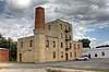
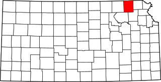
This is a list of the National Register of Historic Places listings in Atchison County, Kansas.

<span class="mw-page-title-main">National Register of Historic Places listings in Doniphan County, Kansas</span>

This is a list of the National Register of Historic Places listings in Doniphan County, Kansas.

<span class="mw-page-title-main">National Register of Historic Places listings in Harvey County, Kansas</span>

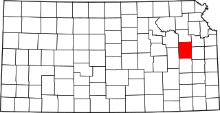
This is a list of the National Register of Historic Places listings in Harvey County, Kansas.

<span class="mw-page-title-main">National Register of Historic Places listings in Douglas County, Kansas</span>

This is a list of the National Register of Historic Places listings in Douglas County, Kansas.

<span class="mw-page-title-main">National Register of Historic Places listings in Morris County, Kansas</span>

This is a list of the National Register of Historic Places listings in Morris County, Kansas.

<span class="mw-page-title-main">National Register of Historic Places listings in Sedgwick County, Kansas</span>

This is a list of the National Register of Historic Places listings in Sedgwick County, Kansas.

<span class="mw-page-title-main">National Register of Historic Places listings in Johnson County, Kansas</span>

This is a list of the National Register of Historic Places listings in Johnson County, Kansas.

<span class="mw-page-title-main">National Register of Historic Places listings in Nemaha County, Kansas</span>

This is a list of the National Register of Historic Places listings in Nemaha County, Kansas.

<span class="mw-page-title-main">National Register of Historic Places listings in Crawford County, Kansas</span>

This is a list of the National Register of Historic Places listings in Crawford County, Kansas.

<span class="mw-page-title-main">National Register of Historic Places listings in Labette County, Kansas</span>

This is a list of the National Register of Historic Places listings in Labette County, Kansas.

<span class="mw-page-title-main">National Register of Historic Places listings in Cloud County, Kansas</span>

This is a list of the National Register of Historic Places listings in Cloud County, Kansas.

<span class="mw-page-title-main">National Register of Historic Places listings in Miami County, Kansas</span>

This is a list of the National Register of Historic Places listings in Miami County, Kansas.

<span class="mw-page-title-main">National Register of Historic Places listings in Osage County, Kansas</span>

This is a list of the National Register of Historic Places listings in Osage County, Kansas.

<span class="mw-page-title-main">National Register of Historic Places listings in Mitchell County, Kansas</span>

This is a list of the National Register of Historic Places listings in Mitchell County, Kansas.

<span class="mw-page-title-main">National Register of Historic Places listings in Finney County, Kansas</span>

This is a list of the National Register of Historic Places listings in Finney County, Kansas.

<span class="mw-page-title-main">National Register of Historic Places listings in Ford County, Kansas</span>

This is a list of the National Register of Historic Places listings in Ford County, Kansas.

<span class="mw-page-title-main">National Register of Historic Places listings in Brown County, Kansas</span>

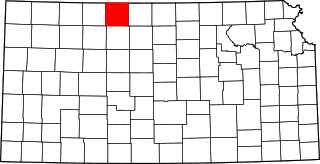
This is a list of the National Register of Historic Places listings in Brown County, Kansas.

<span class="mw-page-title-main">National Register of Historic Places listings in Wabaunsee County, Kansas</span>

This is a list of the National Register of Historic Places listings in Wabaunsee County, Kansas.

<span class="mw-page-title-main">National Register of Historic Places listings in Jackson County, Missouri</span>

This is a list of the National Register of Historic Places listings in Jackson County, Missouri.

<span class="mw-page-title-main">National Register of Historic Places listings in Phillips County, Kansas</span>

This is a list of the National Register of Historic Places listings in Phillips County, Kansas.

References

  1. The latitude and longitude information provided in this table was derived originally from the National Register Information System, which has been found to be fairly accurate for about 99% of listings. Some locations in this table may have been corrected to current GPS standards.
  2. National Park Service, United States Department of the Interior, "National Register of Historic Places: Weekly List Actions", retrieved July 28, 2023.
  3. 1 2 Numbers represent an alphabetical ordering by significant words. Various colorings, defined here, differentiate National Historic Landmarks and historic districts from other NRHP buildings, structures, sites or objects.
  4. "National Register Information System". National Register of Historic Places . National Park Service. March 13, 2009.
  5. The eight-digit number below each date is the number assigned to each location in the National Register Information System database, which can be viewed by clicking the number.
  6. "Fire destroys general store". The Wichita Eagle . January 8, 1997. p. 7B. Retrieved July 4, 2022 via Newspapers.com.