Turon, Kansas

Last updated
Turon, Kansas
Reno County Kansas Incorporated and Unincorporated areas Turon Highlighted.svg
Location within Reno County and Kansas
Map of Reno Co, Ks, USA.png
Coordinates: 37°48′27″N98°25′37″W / 37.80750°N 98.42694°W / 37.80750; -98.42694 Coordinates: 37°48′27″N98°25′37″W / 37.80750°N 98.42694°W / 37.80750; -98.42694 [1]
Country United States
State Kansas
County Reno
Founded1886
Incorporated 1905
Area
[2]
  Total0.45 sq mi (1.15 km2)
  Land0.45 sq mi (1.15 km2)
  Water0.00 sq mi (0.00 km2)
Elevation
[1]
1,762 ft (537 m)
Population
 (2020) [3]
  Total309
  Density690/sq mi (270/km2)
Time zone UTC-6 (CST)
  Summer (DST) UTC-5 (CDT)
ZIP code
67583
Area code 620
FIPS code 20-71800 [1]
GNIS ID 473772 [1]

Turon is a city in Reno County, Kansas, United States. [1] As of the 2020 census, the population of the city was 309. [3]

Contents

History

1915 railroad map of Reno County Stouffer's Railroad Map of Kansas 1915-1918 Reno County.png
1915 railroad map of Reno County

Turon was founded in 1886. It was incorporated as a city in 1905. [4]

In 1887, the Chicago, Kansas and Nebraska Railway built a main line from Herington through Turon to Pratt. [5] In 1888, this line was extended to Liberal. Later, it was extended to Tucumcari, New Mexico and El Paso, Texas. It foreclosed in 1891 and taken over by Chicago, Rock Island and Pacific Railway, which shut down in 1980 and reorganized as Oklahoma, Kansas and Texas Railroad, merged in 1988 with Missouri Pacific Railroad, merged in 1997 with Union Pacific Railroad. Most locals still refer to this railroad as the "Rock Island".

Geography

Turon is located at 37°48′27″N98°25′37″W / 37.80750°N 98.42694°W / 37.80750; -98.42694 (37.807415, -98.427061). [6] According to the United States Census Bureau, the city has a total area of 0.46 square miles (1.19 km2), all of it land. [7]

Climate

The climate in this area is characterized by hot, humid summers and generally mild to cool winters. According to the Köppen Climate Classification system, Turon has a humid subtropical climate, abbreviated "Cfa" on climate maps. [8]

Demographics

Historical population
CensusPop.
1910 572
1920 63110.3%
1930 576−8.7%
1940 5943.1%
1950 6326.4%
1960 559−11.6%
1970 430−23.1%
1980 48111.9%
1990 393−18.3%
2000 43610.9%
2010 387−11.2%
2020 309−20.2%
U.S. Decennial Census

2010 census

As of the census [9] of 2010, there were 387 people, 159 households, and 98 families residing in the city. The population density was 841.3 inhabitants per square mile (324.8/km2). There were 210 housing units at an average density of 456.5 per square mile (176.3/km2). The racial makeup of the city was 84.5% White, 4.1% Native American, 7.5% from other races, and 3.9% from two or more races. Hispanic or Latino people of any race were 12.4% of the population.

There were 159 households, of which 31.4% had children under the age of 18 living with them, 48.4% were married couples living together, 11.3% had a female householder with no husband present, 1.9% had a male householder with no wife present, and 38.4% were non-families. 34.6% of all households were made up of individuals, and 18.2% had someone living alone who was 65 years of age or older. The average household size was 2.43 and the average family size was 3.11.

The median age in the city was 39.6 years. 26.1% of residents were under the age of 18; 10.1% were between the ages of 18 and 24; 20% were from 25 to 44; 26.1% were from 45 to 64; and 17.8% were 65 years of age or older. The gender makeup of the city was 46.3% male and 53.7% female.

2000 census

As of the census [10] of 2000, there were 436 people, 177 households, and 115 families residing in the city. The population density was 950.4 inhabitants per square mile (367.0/km2). There were 218 housing units at an average density of 475.2 per square mile (183.5/km2). The racial makeup of the city was 92.43% White, 0.46% African American, 0.69% Native American, 4.36% from other races, and 2.06% from two or more races. Hispanic or Latino people of any race were 7.34% of the population.

There were 177 households, out of which 30.5% had children under the age of 18 living with them, 54.8% were married couples living together, 9.0% had a female householder with no husband present, and 34.5% were non-families. 30.5% of all households were made up of individuals, and 18.6% had someone living alone who was 65 years of age or older. The average household size was 2.46 and the average family size was 3.11.

In the city, the population was spread out, with 28.7% under the age of 18, 7.8% from 18 to 24, 22.2% from 25 to 44, 20.6% from 45 to 64, and 20.6% who were 65 years of age or older. The median age was 38 years. For every 100 females, there were 92.9 males. For every 100 females age 18 and over, there were 85.1 males.

The median income for a household in the city was $21,429, and the median income for a family was $26,000. Males had a median income of $21,750 versus $19,500 for females. The per capita income for the city was $11,197. About 14.7% of families and 19.3% of the population were below the poverty line, including 30.2% of those under age 18 and 9.2% of those age 65 or over.

Education

The community is served by Fairfield USD 310 public school district. Before the creation of USD 310, the old Turon High School mascot was the Eagles.

Related Research Articles

<span class="mw-page-title-main">Colony, Kansas</span> City in Anderson County, Kansas

Colony is a city in Anderson County, Kansas, United States. As of the 2020 census, the population of the city was 381.

<span class="mw-page-title-main">Garnett, Kansas</span> City in Anderson County, Kansas

Garnett is a city in and the county seat of Anderson County, Kansas, United States. As of the 2020 census, the population of the city was 3,242.

<span class="mw-page-title-main">Hardtner, Kansas</span> City in Kiowa County, Kansas

Hardtner is a city in Barber County, Kansas, United States. As of the 2020 census, the population of the city was 167. It is located 1 mile north of the Kansas / Oklahoma state border.

<span class="mw-page-title-main">Ellinwood, Kansas</span> City in Barton County, Kansas

Ellinwood is a city in the southeast corner of Barton County, Kansas, United States. As of the 2020 census, the population of the city was 2,011.

<span class="mw-page-title-main">Glasco, Kansas</span> City in Cloud County, Kansas

Glasco is a city in Cloud County, Kansas, United States. As of the 2020 census, the population of the city was 441.

<span class="mw-page-title-main">Miltonvale, Kansas</span> City in Cloud County, Kansas

Miltonvale is a city in Cloud County, Kansas, United States. As of the 2020 census, the population of the city was 440.

<span class="mw-page-title-main">Cambridge, Kansas</span> City in Cowley County, Kansas

Cambridge is a city in Cowley County, Kansas, United States. As of the 2020 census, the population of the city was 92.

<span class="mw-page-title-main">Walnut, Kansas</span> City in Crawford County, Kansas

Walnut is a city in Crawford County, Kansas, United States. As of the 2020 census, the population of the city was 187.

<span class="mw-page-title-main">Barnard, Kansas</span> City in Lincoln County, Kansas

Barnard is a city in Lincoln County, Kansas, United States. As of the 2020 census, the population of the city was 64.

<span class="mw-page-title-main">Allen, Kansas</span> City in Lyon County, Kansas

Allen is a city in Lyon County, Kansas, United States. As of the 2020 census, the population of the city was 160.

<span class="mw-page-title-main">Inman, Kansas</span> City in McPherson County, Kansas

Inman is a city in McPherson County, Kansas, United States. As of the 2020 census, the population of the city was 1,341.

<span class="mw-page-title-main">Havensville, Kansas</span> City in Pottawatomie County, Kansas

Havensville is a city in Pottawatomie County, Kansas, United States. As of the 2020 census, the population of the city was 119.

<span class="mw-page-title-main">Nickerson, Kansas</span> City in Reno County, Kansas

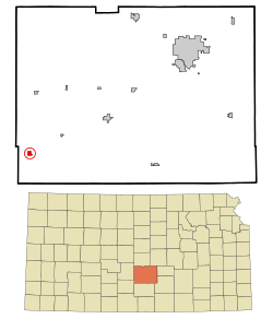
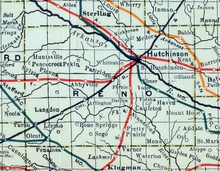
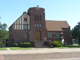
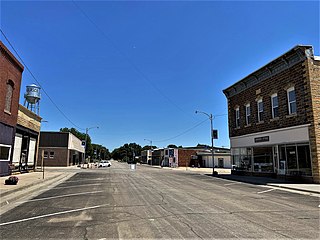
Nickerson is a city in Reno County, Kansas, United States. As of the 2020 census, the population of the city was 1,058. It was named in honor of Thomas Nickerson, former president of Atchison, Topeka and Santa Fe Railway.

<span class="mw-page-title-main">Partridge, Kansas</span> City in Reno County, Kansas

Partridge is a city in Reno County, Kansas, United States. As of the 2020 census, the population of the city was 209.

<span class="mw-page-title-main">Chase, Kansas</span> City in Rice County, Kansas

Chase is a city in Rice County, Kansas, United States. As of the 2020 census, the population of the city was 396.

<span class="mw-page-title-main">McCracken, Kansas</span> City in Rush County, Kansas

McCracken is a city in Rush County, Kansas, United States. As of the 2020 census, the population of the city was 152.

<span class="mw-page-title-main">Alta Vista, Kansas</span> City in Wabaunsee County, Kansas

Alta Vista is a city in Wabaunsee County, Kansas, United States. As of the 2020 census, the population of the city was 409.

<span class="mw-page-title-main">McFarland, Kansas</span> City in Wabaunsee County, Kansas

McFarland is a city in Wabaunsee County, Kansas, United States. As of the 2020 census, the population of the city was 272.

<span class="mw-page-title-main">Prague, Nebraska</span> Village in Nebraska, United States

Prague is a village in Saunders County, Nebraska, United States. The population was 303 at the 2010 census. It was named after Prague, capital of Bohemia.

<span class="mw-page-title-main">Willard, Kansas</span> City in Shawnee and Wabaunsee Counties of Kansas

Willard is a city in Shawnee and Wabaunsee counties in the State of Kansas in the United States. As of the 2020 census, the population of the city was 74.

References

  1. 1 2 3 4 5 "Turon, Kansas", Geographic Names Information System , United States Geological Survey, United States Department of the Interior
  2. "2019 U.S. Gazetteer Files". United States Census Bureau. Retrieved July 24, 2020.
  3. 1 2 "Profile of Turon, Kansas in 2020". United States Census Bureau. Archived from the original on March 28, 2022. Retrieved March 28, 2022.
  4. Blackmar, Frank Wilson (1912). Kansas: A Cyclopedia of State History, Volume 2. Standard Publishing Company. pp.  823.
  5. Rock Island Rail History
  6. "US Gazetteer files: 2010, 2000, and 1990". United States Census Bureau. 2011-02-12. Retrieved 2011-04-23.
  7. "US Gazetteer files 2010". United States Census Bureau. Archived from the original on 2012-01-25. Retrieved 2012-07-06.
  8. Climate Summary for Turon, Kansas
  9. "U.S. Census website". United States Census Bureau . Retrieved 2012-07-06.
  10. "U.S. Census website". United States Census Bureau . Retrieved 2008-01-31.

Further reading