
Reno County is a county located in the U.S. state of Kansas. Its county seat and largest city is Hutchinson. As of the 2020 census, the population was 61,898. The county is named for Jesse Reno, a general during the American Civil War.
Galatia is a city in Barton County, Kansas, United States. As of the 2020 census, the population of the city was 45.

Great Bend is a city in and the county seat of Barton County, Kansas, United States. It is named for its location at the point where the course of the Arkansas River bends east then southeast. As of the 2020 census, the population of the city was 14,733. It is home to Barton Community College.
Hutchinson is the largest city and county seat in Reno County, Kansas, United States, and located on the Arkansas River. It has been home to salt mines since 1887, thus its nickname of "Salt City", but locals call it "Hutch". As of the 2020 census, the population of the city was 40,006.
Pretty Prairie is a city in Reno County, Kansas, United States. As of the 2020 census, the population of the city was 660.

Castleton is a town in Rutland County, Vermont, United States. Castleton is about 15 miles (24 km) to the west of Rutland, the county's seat and most populous city, and about 7 miles (11 km) east of the New York/Vermont state border. The town had a population of 4,458 at the 2020 census. Castleton University is located there, with roots dating to 1787.

Yoder is an unincorporated community in Reno County, Kansas, United States. As of the 2020 census, the population of the community and nearby areas was 165. It is located approximately 10 miles southeast of the city of Hutchinson on K-96. Although Yoder is unincorporated, with no city government, it does have a U.S. Post Office and its own ZIP code (67585). Yoder is the hub of a local Amish community.
Piper is a neighborhood within Kansas City, Kansas, United States. Before Piper was annexed in 1991, it was formerly an unincorporated semi-rural area, similar to Turner.

Welda is an unincorporated community in Anderson County, Kansas, United States. As of the 2020 census, the population of the community and nearby areas was 149.

Prairie City is a ghost town in southeast Douglas County, Kansas, United States, near present-day Baldwin City.

Pierceville is an unincorporated community in Finney County, Kansas, United States. As of the 2020 census, the population of the community and nearby areas was 98. It is located along U.S. Routes 50 and 400, 12 miles (19 km) southeast of Garden City.
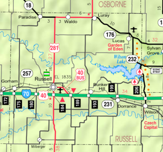
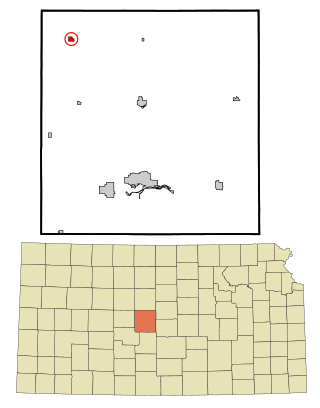
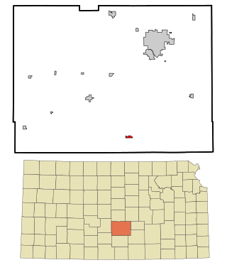
Dubuque is an unincorporated community in Barton and Russell Counties in the U.S. state of Kansas. It is approximately 10 miles (16 km) south of Dorrance.

Brainerd is an unincorporated community in Butler County, Kansas, United States. It is located on the north side of K-196 highway between the cities of Whitewater and Potwin.

Odin is an unincorporated community in Barton County, Kansas, United States. As of the 2020 census, the population of the community and nearby areas was 87. It is located northwest of Claflin at the intersection of NE 140 Rd and NE 90 Ave.

Wayside is an unincorporated community in Montgomery County, Kansas, United States. As of the 2020 census, the population of the community and nearby areas was 19. It is located along U.S. Route 75 northeast of Caney and southwest of Independence.
Darlow is an unincorporated community in Lincoln Township, Reno County, Kansas, United States. It is located several miles west of Yoder along Red Rock Road.
Huntsville is an unincorporated community in Reno County, Kansas, United States. It is located north of Plevna along 4th Ave.
Lerado is an unincorporated community in Reno County, Kansas, United States. Early residents intended to name the community for Laredo, Texas, but a clerical error by the post office resulted in the E and A being swapped.
Medora is an unincorporated community in Reno County, Kansas, United States. It is located northeast of Hutchinson next to K-61 highway.

Yaggy is an unincorporated community in Reno County, Kansas, United States. It is located northwest of Hutchinson, west of Willowbrook, near a railroad.


