Yaggy, Kansas | |
|---|---|
 | |
 Yaggy  Yaggy | |
| Coordinates: 38°05′49″N98°00′32″W / 38.09694°N 98.00889°W [1] | |
| Country | United States |
| State | Kansas |
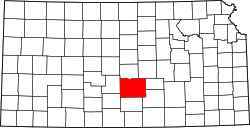
| County | Reno |
| Elevation | 1,562 ft (476 m) |
| Time zone | UTC-6 (CST) |
| • Summer (DST) | UTC-5 (CDT) |
| Area code | 620 |
| FIPS code | 20-80625 |
| GNIS ID | 484759 [1] |
Yaggy is an unincorporated community in Reno County, Kansas, United States. [1] It is located northwest of Hutchinson and west of Willowbrook, near a railroad.