Yoder, Kansas | |
|---|---|
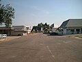
 Hardware & Lumber (2014) | |
 | |
 Yoder  Yoder | |
| Coordinates: 37°56′25″N97°52′6″W / 37.94028°N 97.86833°W [1] | |
| Country | United States |
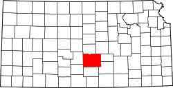
| State | Kansas |
| County | Reno |
| Township | Yoder |
| Founded | 1889 |
| Named after | Valentine Yoder |
| Area | |
• Total | 37.6 sq mi (97.5 km2) |
| • Land | 37.2 sq mi (96.5 km2) |
| • Water | 0.4 sq mi (1.0 km2) |
| Elevation | 1,539 ft (469 m) |
| Population | |
• Total | 165 |
| • Density | 4.4/sq mi (1.7/km2) |
| Time zone | UTC-6 (CST) |
| • Summer (DST) | UTC-5 (CDT) |
| ZIP code | 67585 |
| Area code | 620 |
| FIPS code | 20-80750 |
| GNIS ID | 473653 [1] |
| Website | yoderkansas.com |
Yoder is a census-designated place (CDP) in Reno County, Kansas, United States. [1] As of the 2020 census, the population was 165. [2] It is located approximately 10 miles southeast of the city of Hutchinson on K-96. Yoder is the hub of a local Amish community.