
Rice County is a county located in the U.S. state of Kansas. Its county seat and largest city is Lyons. As of the 2020 census, the county population was 9,427. The county was named in memory of Samuel Allen Rice, Brigadier-General, United States volunteers, killed April 30, 1864, at Jenkins Ferry, Arkansas.

Reno County is a county located in the U.S. state of Kansas. Its county seat and largest city is Hutchinson. As of the 2020 census, the population was 61,898. The county is named for Jesse Reno, a general during the American Civil War.

Morris County is a county located in the U.S. state of Kansas. Its county seat and largest city is Council Grove. As of the 2020 census, the county population was 5,386. The county was named for Thomas Morris, a U.S. Senator from Ohio and anti-slavery advocate.

McPherson County is a county located in the U.S. state of Kansas. Its county seat and largest city is McPherson. As of the 2020 census, the county population was 30,223. The county was named for James McPherson, a general in the American Civil War.

Marion County is a county located in the U.S. state of Kansas. Its county seat is Marion and its most populous city is Hillsboro. As of the 2020 census, the county population was 11,823. The county was named in honor of Francis Marion, a brigadier general of the American Revolutionary War, known as the "Swamp Fox".

Dickinson County is a county in Central Kansas. Its county seat and most populous city is Abilene. As of the 2020 census, the county population was 18,402. The county was named in honor of Daniel Dickinson, a U.S. Senator from New York that was a Kansas statehood advocate.

Hutchinson is the largest city in and the county seat of Reno County, Kansas, United States. The city is located on the Arkansas River. It has been home to salt mines since 1887 but locals call it "Hutch." As of the 2020 census, the population of the city was 40,006.
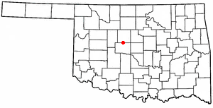
Okarche is a town in Canadian and Kingfisher counties in Oklahoma, United States, that is part of the Oklahoma City Metropolitan Area. The population was 1,141 as of the 2020 United States census.
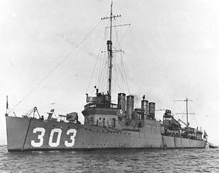
USS Reno (DD-303) was a Clemson-class destroyer built for the United States Navy during World War I.

Castleton is an unincorporated community in Reno County, Kansas, United States. It is located northeast of Pretty Prairie between Castleton Road and North Fork Ninnescah River.

Yoder is a census-designated place (CDP) in Reno County, Kansas, United States. As of the 2020 census, the population was 165. It is located approximately 10 miles southeast of the city of Hutchinson on K-96. Although Yoder is unincorporated, with no city government, it does have a U.S. Post Office and its own ZIP code (67585). Yoder is the hub of a local Amish community.
The Oklahoma, Kansas and Texas Railroad (OKT) was a railroad operating in its namesake states in the 1980s.
The Rural Municipality of Reno No. 51 is a rural municipality (RM) in the Canadian province of Saskatchewan within Census Division No. 4 and SARM Division No. 3. Located in the southwest corner of the province, it is adjacent to the United States border to the south and the Alberta boundary to the west.

The Nevada–California–Oregon Railway was a 3 ft narrow gauge railroad originally planned to connect Reno, Nevada, to the Columbia River. However, only 238 mi (383 km) of track were laid so service never extended beyond Lakeview, Oregon. Because of the company’s reputation for mismanagement, it was often called the "Narrow, Crooked & Ornery" railroad.

This is a list of the National Register of Historic Places listings in Reno County, Kansas.
Darlow is an unincorporated community in Lincoln Township, Reno County, Kansas, United States. It is located several miles west of Yoder along Red Rock Road.


