National Register of Historic Places listings in Miami County, Kansas

Last updated
Location of Miami County in Kansas Map of Kansas highlighting Miami County.svg
Location of Miami County in Kansas

This is a list of the National Register of Historic Places listings in Miami County, Kansas.

Contents

This is intended to be a complete list of the properties and districts on the National Register of Historic Places in Miami County, Kansas, United States. The locations of National Register properties and districts for which the latitude and longitude coordinates are included below, may be seen in a map. [1]

There are 16 properties and districts listed on the National Register in the county.

This National Park Service list is complete through NPS recent listings posted November 5, 2021. [2]
Map all coordinates using: OpenStreetMap  
Download coordinates as: KML

Current listings

[3] Name on the Register [4] ImageDate listed [5] Location City or townDescription
1 Asylum Bridge
Asylum Bridge Asylum Bridge 9 23 2012.JPG
Asylum Bridge
January 4, 1990
(#89002187)
1st St. over the Marais des Cygnes River
38°30′19″N94°56′31″W / 38.5052°N 94.9420°W / 38.5052; -94.9420 (Asylum Bridge)
Osawatomie part of the Metal Truss Bridges in Kansas 1861--1939 Multiple Property Submission (MPS)
2 John Brown Cabin
John Brown Cabin John Brown Cabin 2012-09-25 00-39-34.jpg
John Brown Cabin
March 24, 1971
(#71000319)
John Brown Memorial Park
38°29′56″N94°57′34″W / 38.4989°N 94.9594°W / 38.4989; -94.9594 (John Brown Cabin)
Osawatomie
3 Carey's Ford Bridge
Carey's Ford Bridge Carey's Ford Bridge.JPG
Carey's Ford Bridge
January 4, 1990
(#89002179)
Over the Marais des Cygnes River east of Osawatomie
38°31′14″N95°02′01″W / 38.5206°N 95.0336°W / 38.5206; -95.0336 (Carey's Ford Bridge)
Osawatomie part of the Metal Truss Bridges in Kansas 1861--1939 MPS
4 Congregational Church
Congregational Church Congregational Church (Old Stone Church).jpg
Congregational Church
January 29, 2013
(#12001239)
315 6th St.
38°30′00″N94°57′04″W / 38.5001°N 94.9512°W / 38.5001; -94.9512 (Congregational Church)
Osawatomie
5 Creamery Bridge
Creamery Bridge Creamery Bridge Osawatomie.JPG
Creamery Bridge
March 10, 1983
(#83000434)
FAS 456
38°30′11″N94°57′18″W / 38.5031°N 94.955°W / 38.5031; -94.955 (Creamery Bridge)
Osawatomie part of the Rainbow Arch Marsh Arch Bridges of Kansas Thematic Resource (TR)
6 Hillsdale Archeological District May 12, 1977
(#77000590)
Address restricted
Paola
7 Jackson Hotel
Jackson Hotel Jackson Hotel 2012-09-25 12-39-33.jpg
Jackson Hotel
July 9, 2008
(#08000646)
139 W. Peoria St.
38°34′22″N94°52′46″W / 38.5728°N 94.8794°W / 38.5728; -94.8794 (Jackson Hotel)
Paola
8 Jake's Branch of Middle Creek Bridge July 2, 1985
(#85001432)
Off U.S. Route 69
38°31′11″N94°42′57″W / 38.5197°N 94.7158°W / 38.5197; -94.7158 (Jake's Branch of Middle Creek Bridge)
Louisburg part of the Masonry Arch Bridges of Kansas TR
9 Martin Farm March 7, 2019
(#100003428)
31943 and 31860 W. 247th St.
38°40′48″N94°57′41″W / 38.6801°N 94.9613°W / 38.6801; -94.9613 (Martin Farm)
Paola vicinity
10 Miami County Courthouse
Miami County Courthouse Miami county kansas courthouse 2009.jpg
Miami County Courthouse
March 1, 1973
(#73000768)
East of the junction of Miami and Silver Sts.
38°34′16″N94°52′42″W / 38.5711°N 94.8783°W / 38.5711; -94.8783 (Miami County Courthouse)
Paola
11 Miami County Mercantile Company April 2, 2021
(#100006325)
121 South Pearl St.
38°34′16″N94°52′41″W / 38.5712°N 94.8781°W / 38.5712; -94.8781 (Miami County Mercantile Company)
Paola
12 William Mills House
William Mills House William Mills House 02.jpg
William Mills House
November 20, 1986
(#86003291)
212 1st St.
38°30′10″N94°56′33″W / 38.5028°N 94.9425°W / 38.5028; -94.9425 (William Mills House)
Osawatomie
13 New Lancaster General Store
New Lancaster General Store New Lancaster General Store 03.jpg
New Lancaster General Store
October 9, 2013
(#13000817)
36688 New Lancaster Rd.
38°27′45″N94°43′58″W / 38.4626°N 94.7328°W / 38.4626; -94.7328 (New Lancaster General Store)
New Lancaster
14 New Lancaster Grange Hall, No. 223 October 9, 2013
(#13000818)
12655 W. 367th St.
38°27′44″N94°43′58″W / 38.4621°N 94.7328°W / 38.4621; -94.7328 (New Lancaster Grange Hall, No. 223)
New Lancaster
15 Pottawatomie Creek Bridge
Pottawatomie Creek Bridge Pottawatomie Creek Bridge 9 2012.JPG
Pottawatomie Creek Bridge
March 10, 1983
(#83000433)
FAS 1604
38°29′07″N94°57′02″W / 38.4853°N 94.9506°W / 38.4853; -94.9506 (Pottawatomie Creek Bridge)
Osawatomie part of the Rainbow Arch Marsh Arch Bridges of Kansas TR
16 Soldiers' Monument
Soldiers' Monument Soldier's Monument - Osawatomie, KS.jpg
Soldiers' Monument
September 17, 2012
(#12000386)
Northeast corner of Main & 9th Sts.
38°29′53″N94°57′24″W / 38.4981°N 94.9566°W / 38.4981; -94.9566 (Soldiers' Monument)
Osawatomie

See also

Related Research Articles

National Register of Historic Places listings in Miami-Dade County, Florida

This is a list of the National Register of Historic Places listings in Miami-Dade County, Florida.

National Register of Historic Places listings in Lucas County, Ohio

This is a list of the National Register of Historic Places listings in Lucas County, Ohio.

National Register of Historic Places listings in Miami County, Ohio

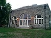
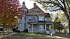
This is a list of the National Register of Historic Places listings in Miami County, Ohio.

National Register of Historic Places listings in Doniphan County, Kansas

This is a list of the National Register of Historic Places listings in Doniphan County, Kansas.

National Register of Historic Places listings in Harvey County, Kansas

This is a list of the National Register of Historic Places listings in Harvey County, Kansas.

National Register of Historic Places listings in Douglas County, Kansas

This is a list of the National Register of Historic Places listings in Douglas County, Kansas.

National Register of Historic Places listings in Morris County, Kansas

This is a list of the National Register of Historic Places listings in Morris County, Kansas.

National Register of Historic Places listings in Sedgwick County, Kansas

This is a list of the National Register of Historic Places listings in Sedgwick County, Kansas.

National Register of Historic Places listings in Chase County, Kansas

This is a list of the National Register of Historic Places listings in Chase County, Kansas.

National Register of Historic Places listings in Franklin County, Kansas

This is a list of the National Register of Historic Places listings in Franklin County, Kansas.

National Register of Historic Places listings in Johnson County, Kansas

This is a list of the National Register of Historic Places listings in Johnson County, Kansas.

National Register of Historic Places listings in Reno County, Kansas

This is a list of the National Register of Historic Places listings in Reno County, Kansas.

National Register of Historic Places listings in Saline County, Kansas

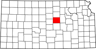
This is a list of the National Register of Historic Places listings in Saline County, Kansas.

National Register of Historic Places listings in Crawford County, Kansas

This is a list of the National Register of Historic Places listings in Crawford County, Kansas.

National Register of Historic Places listings in Labette County, Kansas

This is a list of the National Register of Historic Places listings in Labette County, Kansas.

National Register of Historic Places listings in Cloud County, Kansas

This is a list of the National Register of Historic Places listings in Cloud County, Kansas.

National Register of Historic Places listings in Miami County, Indiana

This is a list of the National Register of Historic Places listings in Miami County, Indiana.

National Register of Historic Places listings in Wabaunsee County, Kansas

This is a list of the National Register of Historic Places listings in Wabaunsee County, Kansas.

National Register of Historic Places listings in Miami

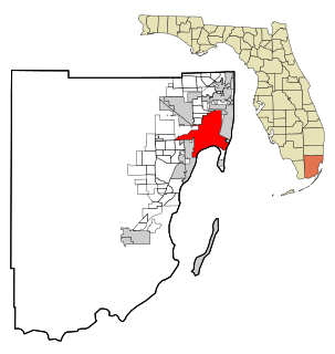
This is a list of the National Register of Historic Places listings in Miami, Florida.

National Register of Historic Places listings in Republic County, Kansas

This is a list of the National Register of Historic Places listings in Republic County, Kansas.

References

  1. The latitude and longitude information provided in this table was derived originally from the National Register Information System, which has been found to be fairly accurate for about 99% of listings. Some locations in this table may have been corrected to current GPS standards.
  2. National Park Service, United States Department of the Interior, "National Register of Historic Places: Weekly List Actions", retrieved November 5, 2021.
  3. Numbers represent an alphabetical ordering by significant words. Various colorings, defined here, differentiate National Historic Landmarks and historic districts from other NRHP buildings, structures, sites or objects.
  4. "National Register Information System". National Register of Historic Places . National Park Service. March 13, 2009.
  5. The eight-digit number below each date is the number assigned to each location in the National Register Information System database, which can be viewed by clicking the number.